
Snake River Plain aquifer
The Snake River Plain aquifer underlies the Snake River Plain, which extends from near the western boundary of Yellowstone National Park in eastern Idaho to the Idaho-Oregon border where the Snake River enters Hells Canyon.
The Snake River Plain controls the economy of much of southern Idaho, north and west of Pocatello (Stearns and others, 1938). Three million acres of farmland on the Snake River Plain are irrigated, with approximately one third from wells and the remaining two thirds from canals. This extensive irrigation system is the primary reason that Idaho has the highest per capita water consumption in the U.S.
PDF slideshows: Water and the Snake River Plain by Paul Link
Overview of the Snake River Plain aquifer
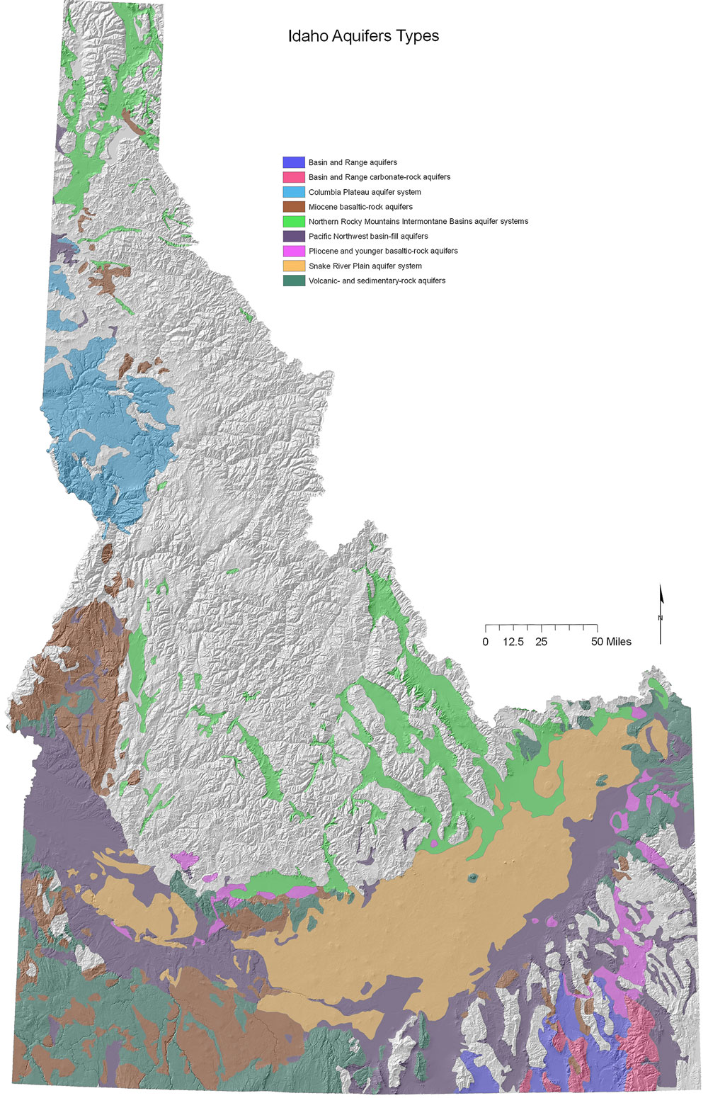
(Above) Idaho's aquifers are hosted in many different sediment and rock types.
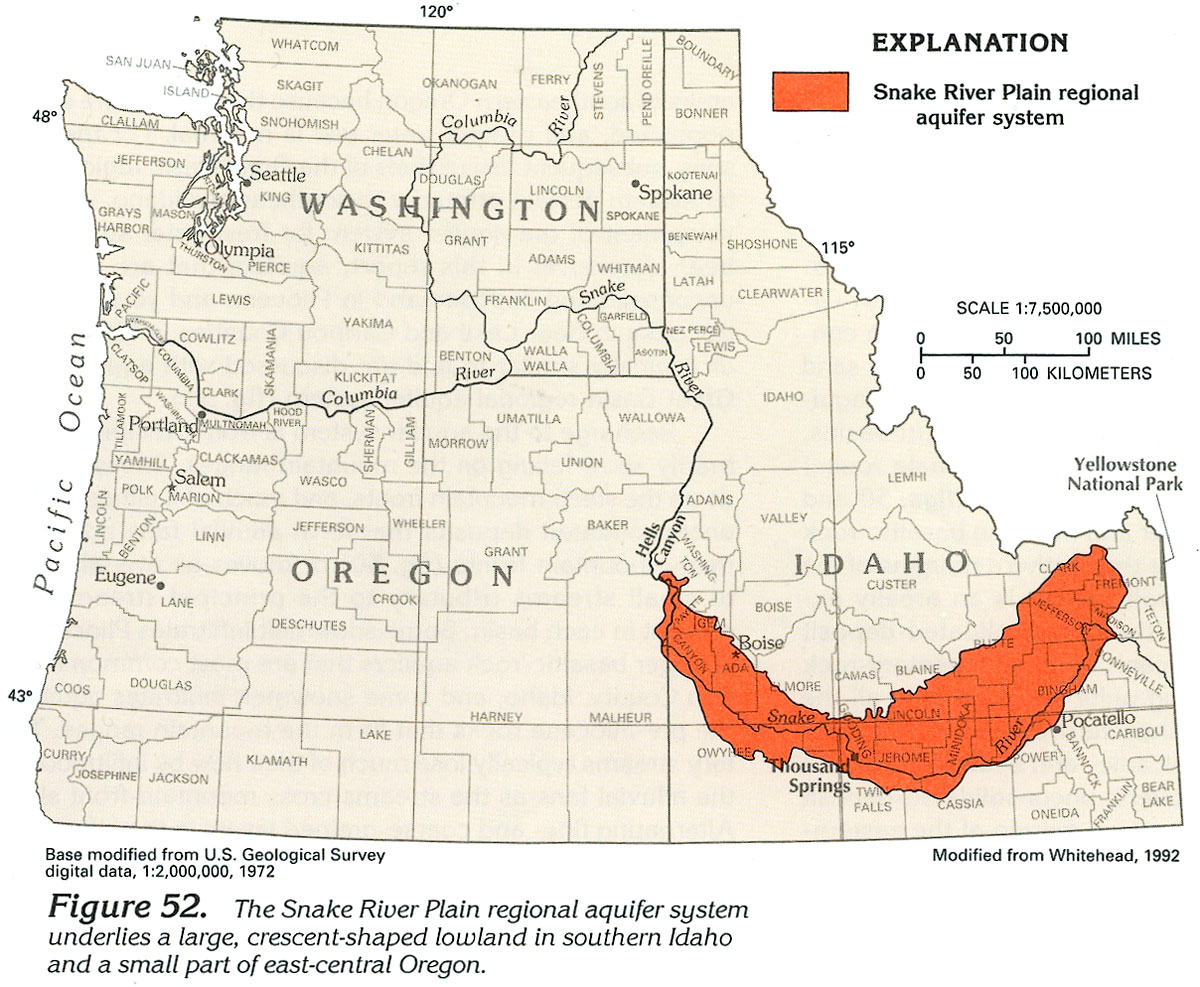
(Above) Map showing the location of the Snake River Plain. From http://pubs.usgs.gov/ha/ha730/ch_h/H-Snake_River1.html
The Snake River Plain is underlain by fractured basalt lava flows, rhyolite, and unconsolidated sediments. Interbeds between the basalt layers are mainly sand, silt, and clay, with smaller amounts of volcanic ash. Within basalts, permeable zones are mainly the tops and bottoms of lava flows, with columnar jointing in between providing slower vertical transmission of water. The rhyolite that underlies the basalt does not have high permeability because many of the pore spaces are filled with chemical precipitates. Unconsolidated sediments beneath the plain contain a high percentage of intergranular pore spaces, which are permeable, yet are resistive to flow.
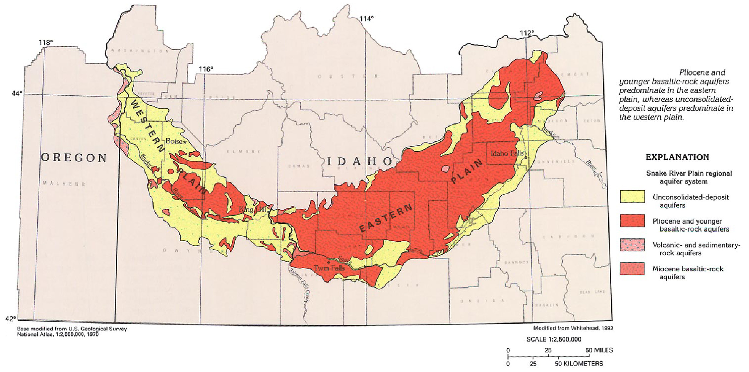
(Above) Map showing the regional geology of the Snake River Plain. Shows the distinction between the eastern and western parts of the Plain. From U. S. Geological Survey Website: http://pubs.usgs.gov/ha/ha730/ch_h/H-Snake_River1.html
Hydrologic and geologic conditions along the Snake River change abruptly between Salmon Falls Creek and King Hill , Idaho , therefore the Snake River Plain aquifer can be divided into two areas: the eastern aquifer and the western aquifer. In the eastern aquifer, the aquifer system consists primarily of Pliocene and younger basaltic rocks with some overlying and interbedded unconsolidated deposits. Much of the water is released through springs (Wood and Low, 1988). In the western plain, the aquifer system consists primarily of unconsolidated deposits with some Pliocene and younger basaltic rocks.
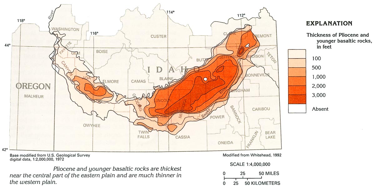
(Left/Above) Map showing thickness of basalts in the Snake River Plain. From http://pubs.usgs.gov/ha/ha730/ch_h/H-Snake_River1.html
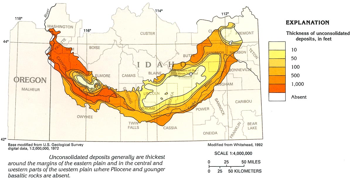
(Left/Above) Map showing the thickness of unconsolidated sediments in the Snake River Plain. From http://pubs.usgs.gov/ha/ha730/ch_h/H-Snake_River1.html
Eastern Snake River Plain aquifer
Physical Characteristics
The aquifer beneath the eastern Snake River Plain covers an area of approximately 28,000 square kilometers. Hosted in layered basalts with occasional sediment deposited between layers, the highly fractured rubble zones at the contacts between layers provide the primary conduit for ground-water flow. Primarily considered to be an unconfined aquifer, it may locally respond as a confined aquifer during short duration pumping (Whitehead, 1992). Confined aquifers are found in between lower permeability sediments between basalt layers.
Total thickness of basalts is estimated to be more than 1,500 meters, however groundwater flows most rapidly in the upper 90 – 150 meters, which is the most productive portion of the aquifer. Interconnected pore spaces in the rubbly tops of lava flows transmit water very readily. Well yields above 3,000 gallons per minute are not uncommon. Transmissivity is very high, and commonly exceeds approximately 83,500 square meters per day in many places. Total ground-water storage in the upper 150 meters of the aquifer is estimated at 200 to 300 million acre-feet, roughly the equivalent of Lake Erie. The aquifer drains to the Snake River and flows mainly southwest (Lindholm and others, 1987).
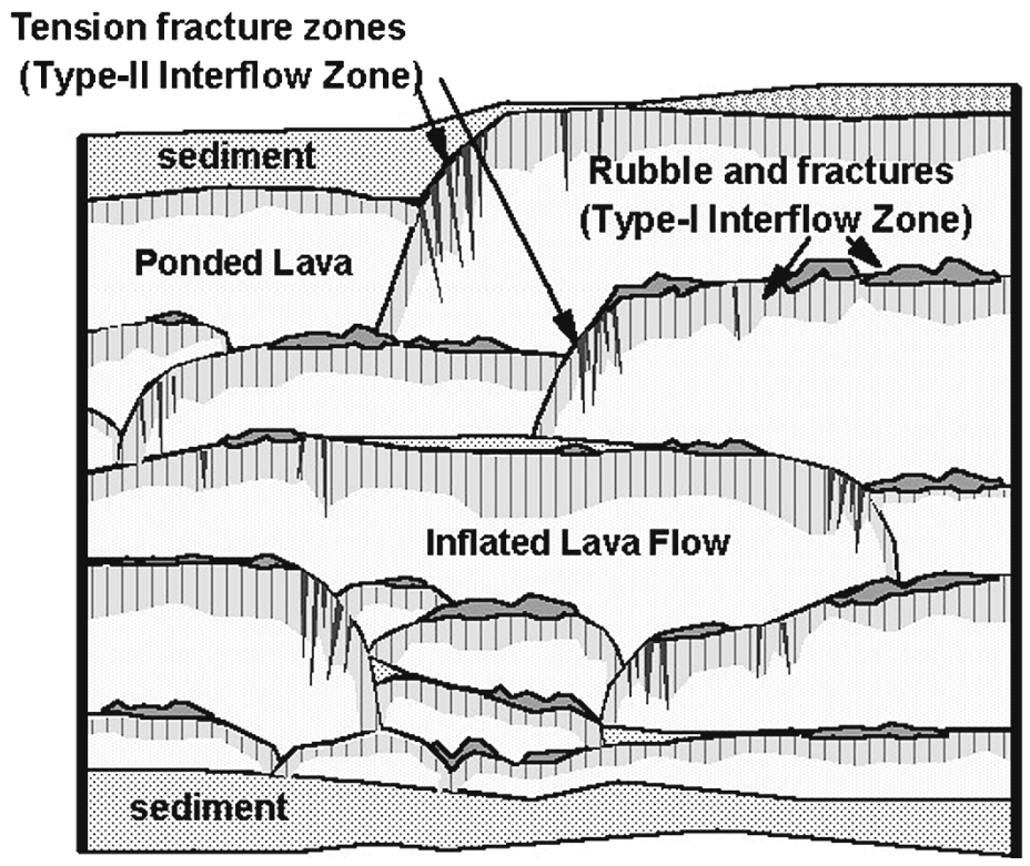
(Above) Conceptual model of eastern Snake River Plain aquifer stratigraphy, showing stacked pahoehoe lava flows, interflow zones, and sedimentary interbeds (from Welhan et al., 2002).
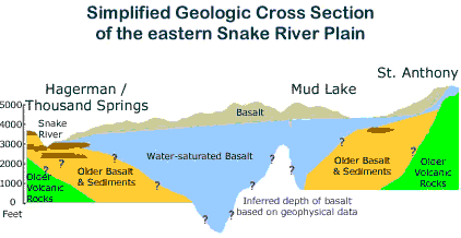
(Above) West to east (from right to left) cross section along the axis of the eastern Snake River Plain, showing the possible saturation zone of the aquifer. From the Digital Atlas of Idaho.
(Right/Below) Aquifer host-rocks, predominantly basalt, are shown. From the U. S. Geological Website, http://pubs.usgs.gov/ha/ha730/ch_h/H-Snake_River1.html
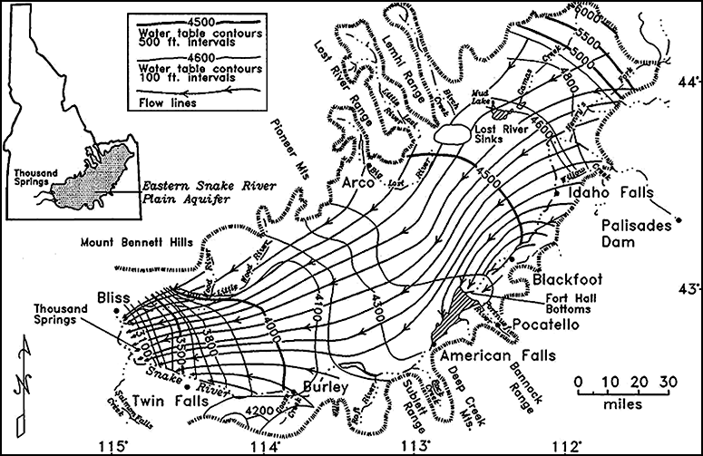
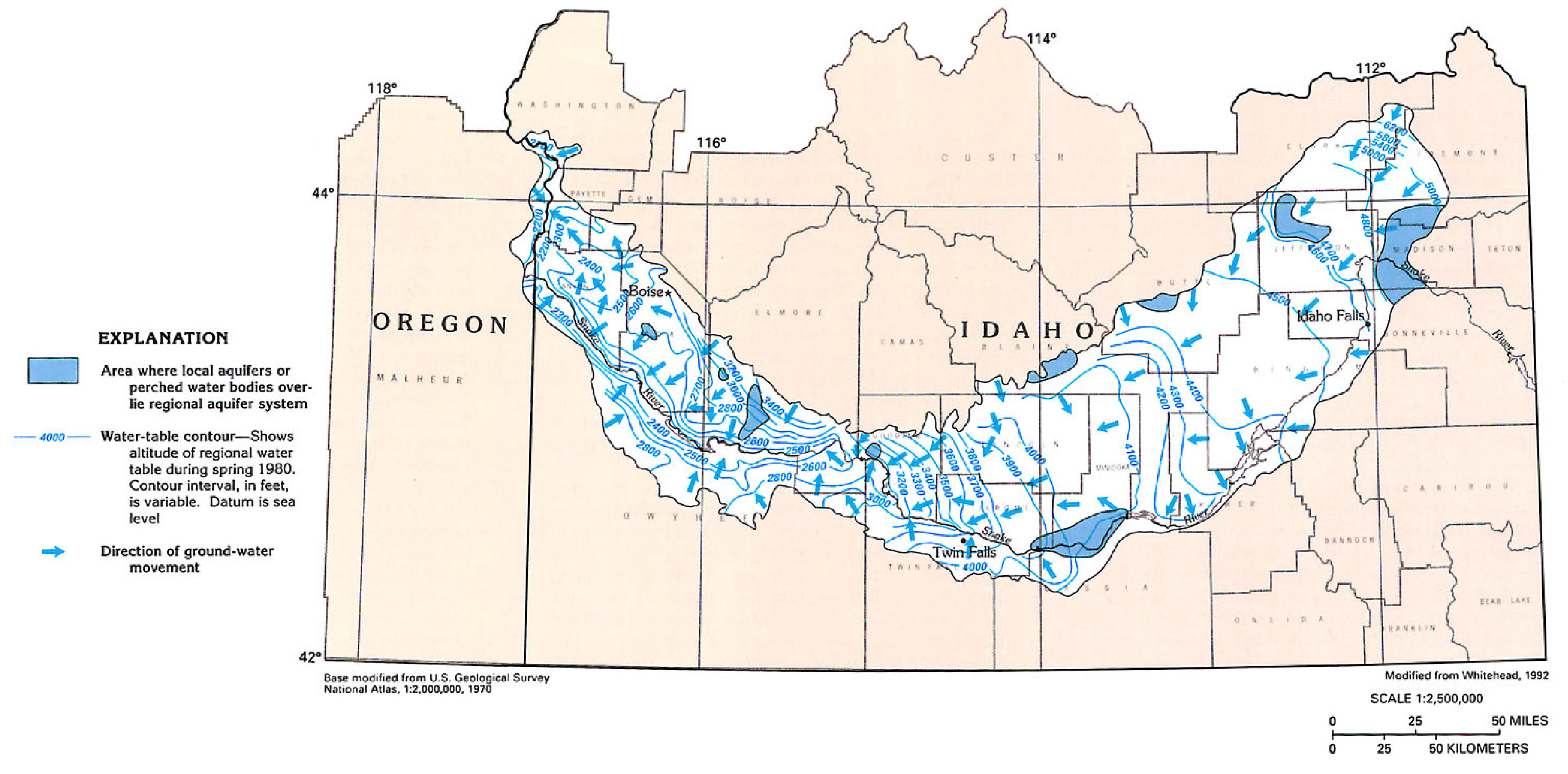
(Left/Above) Direction of flow throughout the eastern Snake River Plain aquifer and the two main areas of natural discharge at Thousand Springs and near American Falls. From Link and Phoenix , 1996.
As the flow arrows show in Figure 7, there are two main areas of natural discharge within the eastern Snake River Plain aquifer: Springs along the Snake River near American Falls Reservoir, have discharge of about 2,600 cfs and at Thousand Springs, west of Twin Falls where the collective discharge is about 5,200 cfs.
Recharge into the Eastern Snake River Plain aquifer is predominantly from infiltration of applied irrigation water, infiltration of streamflow, and ground-water inflow from adjoining mountain drainage basins. Some recharge may be from direct infiltration of precipitation, however the hot, arid climate of the Plain make this a minimal contribution (Lindholm and others, 1987). Main contributing rivers are the Big Lost, Little Lost, Birch Creek, and Camas Creek, which drain the mountain ranges to the north and east of the Plain.
Human Impact on Eastern Snake River Plain Aquifer
Human activity has had a tremendous impact on the water balance of the eastern aquifer. About sixty percent of total recharge to the aquifer is derived from irrigation with surface water. Most groundwater still leaves the aquifer via springs and seepage losses in two major upper basin reaches, although pumping withdrawals contribute significantly to the aquifer's total losses.
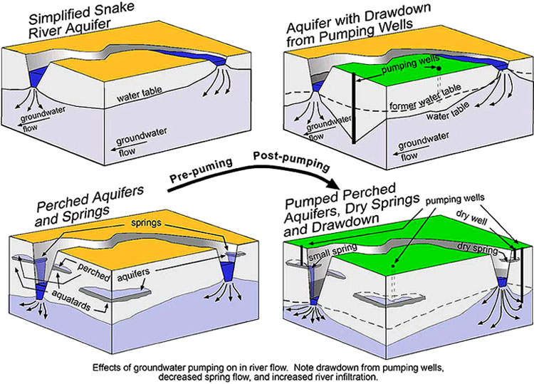
(Above) Pre-pumping and post-pumping and effects on aquifers.
Irrigation practices have and continue to exert a major influence on water resources of the Eastern Snake River Plain. Prior to 1950, spring discharges and the water table between Kimberly and Bliss rose by 60-70 feet on average during the period 1907-1959, accounting for a cumulative increase of more than 5% of the aquifer's total storage. This was due to the common early practice of flood irrigation: farmlands were irrigated by releasing large amounts of water (either from reservoirs or canals) over agricultural fields. This was not a very efficient practice and most water infiltrated back into the aquifer system.
During the 1950s and 1960s more land was irrigated with groundwater and irrigation efficiency increased through the use of sprinkler irrigation. This resulted in a substantial decline in groundwater levels in parts of the Plain between 1975 and 1995, leading to a cumulative decrease in aquifer storage of about 3%, and decreased spring flows between Kimberley and Bliss.
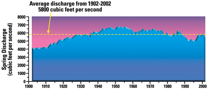
(Above) Graph showing spring discharge levels. From the Idaho Department of Environmental Quality.
In general, the declines in spring discharge and ground water levels have been caused by increased groundwater pumping, more efficient irrigation methods, and reduced reliance on surface water diversions for irrigation. Localized declines may be predominantly the result of increased pumping withdrawals in some areas.
Human activity also has an effect on the water quality of the aquifer. Most common sources of contamination include urbanization, urban and agricultural waste disposal, agricultural runoff, and disposal of radioactive and chemical wastes from the INL. Due to the massive volume of water and the high flow rates of the aquifer, these contaminations are localized and are diluted by the time they reach the downstream natural discharge area in Thousand Springs. However, the localized areas of lowered water quality do pose a problem in these areas for domestic and irrigation uses.
Western Snake River Plain aquifer
Physical Characteristics
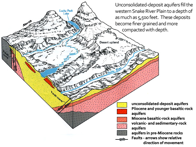
The thick layers of unconsolidated sediments overlying Miocene-age volcanic rocks distinguish the western Snake River Plain from the eastern Snake River Plain. The Western Snake River Plain contains coarse and fine-grained unconsolidated sediment up to 1525 meters thick, which is thickest in the western part of the Plain, near the Idaho-Oregon state border. Quaternary basalt is present up to 610 meters thick, mainly in the central and eastern parts of the Western Plain (Figure 3). Pliocene and younger basaltic-rock aquifers are the major aquifers in the central part of the Western Aquifer. Unconsolidated sand and gravel aquifers predominate along the Boise River and the northern boundary of the western plain and are extremely productive. Older fine-grained deposits of the unconsolidated-deposit aquifers predominate in the remainder of the western plain with common well-yields of only 1 to 20 gallons per minute. The water in these aquifers is generally under confined conditions. Discontinuous lenses of sand and gravel in the otherwise fine-grained deposits have well-yields between 1 to 100 gallons of water per minute.
(Left/Above) Aquifer host-rocks, predominantly unconsolidated sediments and some basalt. From the U. S. Geological Website, http://capp.water.usgs.gov/gwa/ch_h/H-text8.html.
Permeable zones exist at depths of 1675 meters below the land surface, but the most permeable zones are in the upper 150 meters. Estimated transmissivity of the upper 150 meters of the unconsolidated-deposit aquifers is generally less than 1900 square meters per day.
Flow directions generally feed into main drainages, directed toward the Snake River in the eastern part of the Western Plain and along the southwestern and western side of the western plain. In the northern part of the Western Plain, flow is directed toward the Boise River. An overall regional flow direction also follows the northwesterly arcuate shape of the Western Plain, toward the Oregon-Idaho border.
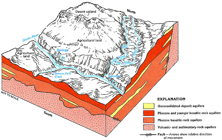
(Right/Below) Flow directions and aquifer elevations for entire Snake River Plain Aquifer. Note western Aquifer and flow into Snake River, Boise River , and overall west-northwestward flow. From the U. S. Geological Website, http://pubs.usgs.gov/ha/ha730/ch_h/H-Snake_River1.html
Treasure Valley
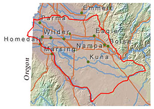
Most studies on the Western Snake River Plain Aquifer have focused on the Treasure Valley, which covers approximately the western half of the Western Snake River Plain Aquifer. The Treasure Valley includes the lower Boise River basin and extends south to the Snake River.
The Treasure Valley contains a complex system of shallow, intermediate, and deep aquifers. Shallow aquifers often supply water to rural domestic and some irrigation wells. Municipal, industrial, and some irrigation wells typically draw water from deeper aquifers. Intermediate aquifers, found in the transition from shallow to deep zones, supply water for domestic, irrigation, and municipal uses.
Local shallow aquifers are often contained in the Pliestocene-age Snake River Group sediments. Depths of these aquifers are generally less than 75 meters below ground surface. Ground water in shallow aquifers generally originates at ground surface, in the form of precipitation, infiltration from irrigated areas, or infiltration from river and stream channels or canals. Shallow aquifers can contain very localized flow systems such as from an irrigated field to the nearest drainage ditch, or they can extend tens of miles.
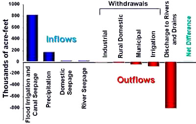
Approximately 50% of the Treasure Valley land area is flood or sprinkler irrigated. Seepage from flood irrigation (including canal seepage) accounts for approximately 95% of recharge to shallow aquifers. Only a small portion of this water, however, enters deeper aquifers; most of the shallow aquifers discharge into river, canal, or ditch channels.
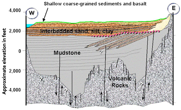
(Left/Above) Generalized cross-section of the sediments underlying the western Snake River Plain, near the Boise area. From Idaho Department of Water Resources, Treasure Valley Hydrology.
Most municipal water in the Treasure Valley comes from ground water. Municipal water is supplied by a variety of entities, including public companies, cities, and water districts. The largest water purveyor in the Treasure Valley is United Water Idaho (UWI). United Water Idaho customers receive their water from both groundwater and surface water sources. Groundwater is drawn from wells drilled into deep aquifers that produce about 14 billion gallons of water per year. The groundwater quality is excellent and free from harmful bacterial contamination. As a result, treatment is limited to disinfection with chlorine. Unfortunately, the advantages of excellent bacteria-free groundwater are often accompanied by disadvantages like high iron and manganese content. These sources are being improved by either screening out water high in these minerals or by adding a phosphate compound to hold these minerals in solution.
(Left/Above) Table from the Digital Atlas of Idaho, http://imnh.isu.edu/digitalatlas.
Ground water is used to irrigate approximately 42,300 acres of farmland, primarily in the southern portion of the valley. In addition, many of the irrigators dependent on surface water supplies use supplemental irrigation wells during periods of drought. It is estimated that approximately 72,000 acre feet of ground water are withdrawn annually for agricultural irrigation.
Continue to Module 15 - Snake River Plain aquifer
References
Ground Water Atlas of the United States: Idaho , Oregon , Washington: Snake River Plain Aquifer System: U.S. Geological Survey, HA 730-H. http://pubs.usgs.gov/ha/ha730/ch_h/H-text8.html
Johnson, G., Cosgrove, D., and Lovell, M., 1998. Snake River Basin Surface Water-Ground Water Interaction, Idaho Water Resource Research Institute, University of Idaho.
Kjelstrom, L.C., 1995, Streamflow gains and losses in the Snake River and ground-water budgets for the Snake River Plain, Idaho and eastern Oregon: U.S. Geological Survey Professional Paper 1408-C, 47 p.
Kjelstrom, L. C., 1986, Flow characteristics of the Snake River and water budget for the Snake River Plain, Idaho and eastern Oregon: U.S. Geological Survey Hydrological Investigations Atlas HA-680, scale 1: 100,000,000, 2 sheets.
Lindholm, G.F., Garabedian, S.P., Newton, G.D., and Whitehead, R.L., 1987, Configuration of the water table and depth to water, spring 1980, water level fluctuations, and water movement in the Snake River Plain regional aquifer system, Idaho and eastern Oregon: U.S. Geological Survey Hydrologic Investigations Atlas HA-703, scale 1:500,000, 1 sheet.
Lindholm, G.F., and Goodell, S.A., 1986, Irrigated acreage and other land uses on the Snake River Plain, Idaho and eastern Oregon: U.S. Geological Survey Hydrologic Investigations Atlas HA-691, scale 1:500,000, 1 sheet.
Low, W.H., 1987, Solute distribution in ground and surface water in the Snake River basin, Idaho and eastern Oregon: U.S. Geological Survey Hydrologic Investigations Atlas HA-696, scale 1:1,000,000, 2 sheets.
Neely, K.W. and Crockett, J.K., 1998, Ground water quality characterization and initial trend analysis for the Treasure Valley shallow and deep hydrologic subareas: No. 50 Part 3, Idaho Department of Water Resources.
Orr, B. R., 1997. Geohydrology of the Idaho National Engineering and Environmental Laboratory, Eastern Snake River Plain, Idaho: U.S. Geological Survey, Fact Sheet FS-130-97, http://pubs.usgs.gov/fs/FS-130-97/#HDR01.
Stearns, H.T., Crandall, L., and Steward, W. G., 1938, Geology and groundwater resources of the Snake River Plain in southeastern Idaho: U.S. Geological Survey Water Supply Paper 774, 268 p.
Urban, S.M. and Petrich, C.R., 1998, 1996 Water Budget for the Treasure Valley Aquifer System, Idaho Department of Water Resources Research Report.
U.S. Geological Survey, 1985, National water summary, 1984-Hydrologic events, selected water-quality trends, and ground-water resources: U.S. Geological Survey Water-Supply Paper 2275, 467 p.
Whitehead, R.L., 1986, Geohydrologic framework of the Snake River Plain , Idaho and eastern Oregon: U.S. Geological Survey Hydrologic Investigations Atlas HA-681, scale 1:1,000,000, 3 sheets.
Whitehead, R. L., 1992, Geohydrologic framework of the Snake River Plain regional aquifer system, Idaho and eastern Oregon: U.S. Geological Survey Professional Paper 1408-B, 32 p.
Wood, W.W. and Low, W.H., 1988, Solute geochemistry of the Snake River Plain regional aquifer system, Idaho and eastern Oregon: U.S. Geological Survey Professional Paper 1408-D, 79 p.
Credits
This page was originally assembled from the Digital Atlas of Idaho unit on the Snake River Plain by Laura DeGrey-Ellis and Paul Link, Idaho State University; it was modified and updated by Dave Pearson at Idaho State University.