
Mesoproterozoic Belt Supergroup
Rocks of the Middle Proterozoic Belt Supergroup (1470 to 1380 Ma) host the Silver Valley ore deposits of the Idaho panhandle and underlie much of the state north and west of Salmon, Idaho and in the Beaverhead Mountains and Lemhi Range of east-central Idaho.
The enigma of the Belt Supergroup is well-summarized by a quote from Dr. Don Winston (1931 - 2022), who worked extensively on the rocks of the Belt Supergroup while a professor at the University of Montana:
"The Belt was deposited in a huge intracratonic basin that stretched across western Montana , northern Idaho and into eastern Washington and Canada. It was filled by sand, silt, clay, and carbonate sediments that locally reach more than 18 km thick. The sedimentary structures of these rocks are beautifully preserved, since they were deposited 1.5 to 1.4 billion years ago. They reveal a world of pure sedimentary processes unfettered by plants and animals. [They] reveal a world of gigantic sheetflood alluvial aprons and shallow seas or lakes, for which there are no modern counterparts."
The immense area (>200,000 km2) and thickness (>15 km) of the Belt Supergroup make it one of the largest sedimentary basins on Earth. It also was deposited prior to evolution of burrowing organisms and thus preserves some spectacular sedimentary structures. These features have helped the Belt Supergroup captivate the imaginations of generations of geologists and the details are still being worked out.
PDF slideshows: Belt Supergroup: central Idaho and Glacier National Park by Paul Link; Belt Supergroup: northern Idaho by Jim Cash
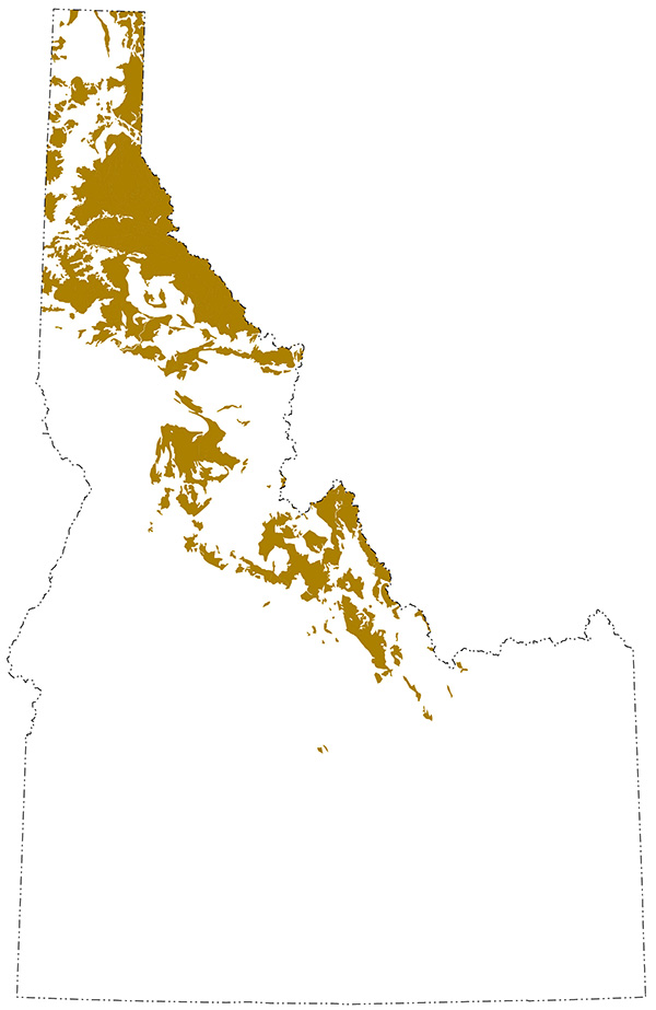
Exposures of Belt Supergroup rocks in Idaho
Geology, Age, and Extent of Belt Supergroup
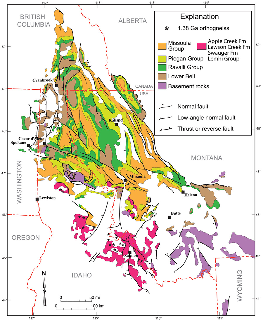 Belt Supergroup strata (and their metamorphosed equivalents) are exposed in Idaho, Montana, and southeastern British Columbia (modified from Lonn et al., 2020).
The Belt Supergroup is an immense package (15-20 km thick) of sedimentary rocks that were deposited on Archean and Paleoproterozoic crystalline basement from 1470 to 1380 million years ago. The Belt Supergroup extends southward from Canada, where it is called the Purcell Supergroup, through western Montana and into northern, central, and east-central Idaho. The Belt Supergroup extends westward into eastern Washington. Most of the spectacularly glacially sculpted rocks in Glacier National Park are Belt Supergroup.
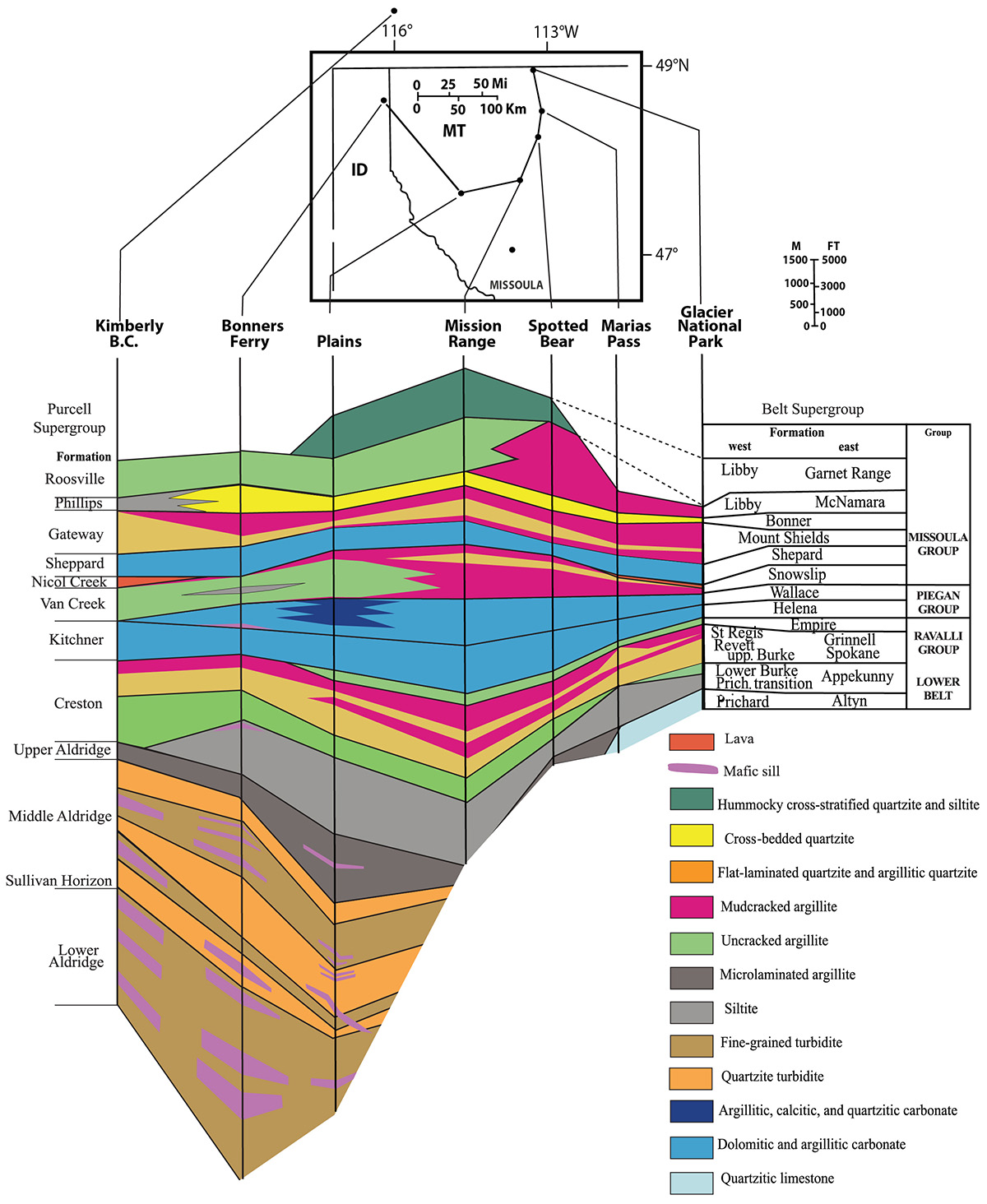
Belt Supergroup stratigraphy
The Belt Supergroup has been subdivided into four major units, from older to younger, 1) the Lower Belt, 2) the Ravalli Group, 3) the Piegan Group, and 4) the Missoula Group.
The Lower Belt is composed predominantly of the Prichard Formation, which is a deep-water facies of a southwest-derived fine-grained clastic wedge. Some detrital zircons in the Prichard Formation are non-North American and were likely derived from the eastern Australian craton.
The Ravalli Group is a largely subaerial clastic wedge, with the same southwestern provenance.
The Piegan Group consists of cyclic carbonate-siliciclastic deposits.
Finally, the Missoula Group (including Lemhi Group, Swauger, Lawson Creek, and Apple Creek formation rocks in east-central Idaho) contains another fluvial clastic wedge that was derived from the south from a different river system than supplied the Ravalli Group.
Belt strata in the Idaho panhandle are correlative with the Lower Belt, Ravalli Group, and Piegan Group, which is the oldest part of the Belt Supergroup (modified from Lonn et al., 2020).
In central and east-central Idaho, Belt Supergroup rocks belong to the Lemhi Group and overlying Swauger, Lawson Creek, and Apple Creek formations, which are thought to be equivalent in age to the Missoula Group, which is the youngest part of the Belt stratigraphy elsewhere. These rocks are coarser grained than their Montana age-equivalents of the Missoula Group. Figure modified from Lonn et al. (2020).
Belt Supergroup tectonic setting
Belt Supergroup rocks were deposited in the largest Middle Proterozoic basin on the North American continent. Most workers interpret that the Belt basin was formed as an intracratonic basin and periodically connected to the world ocean. At other times, it was enclosed and formed lacustrine deposits (Ross and Villeneuve, 2003). Though most workers agree that the basin formed during rifting of the 1.45 Ga Middle Proterozoic supercontinent Nuna, there is extensive debate about whether extension resulted in formation of an ocean basin and complete continental breakup or if rifting failed prior to forming a major ocean basin. Plate reconstruction for this time period is not easy and is an active area of research.
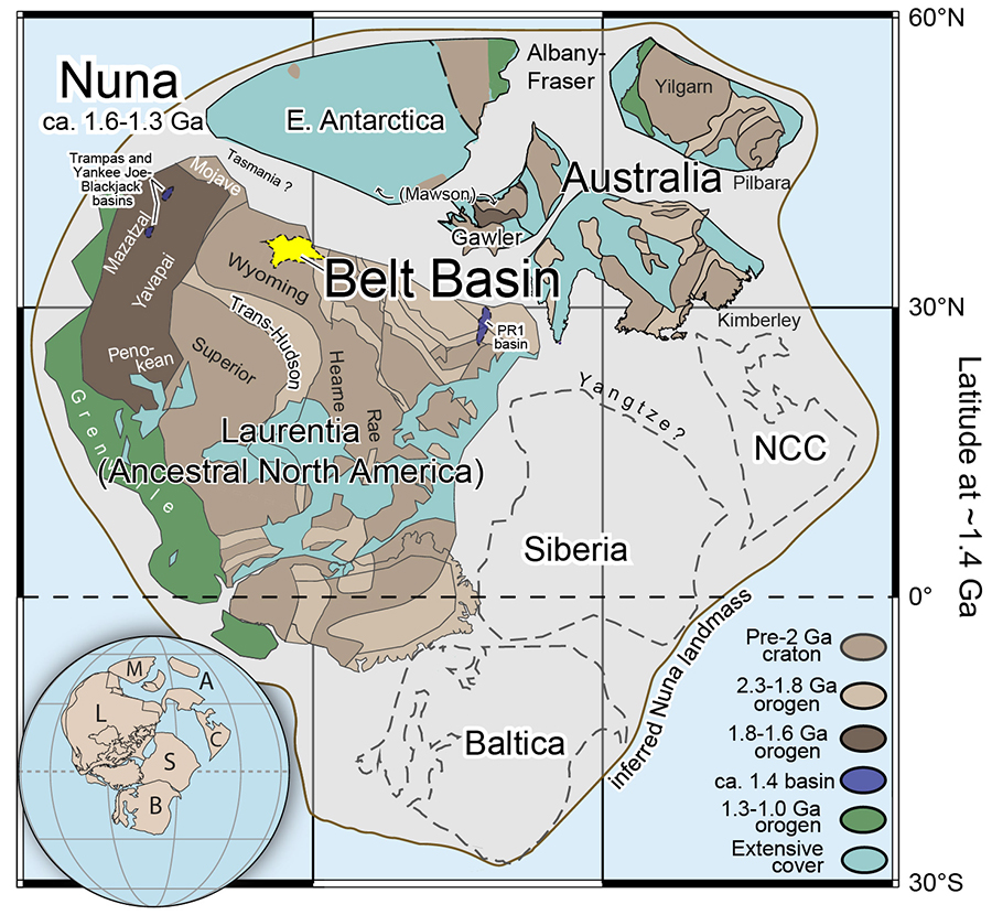
Hypothesized plate tectonic configuration of supercontinent Nuna at ca. 1.6-1.3 Ga, showing the reconstructed position of the Belt basin (modified from Brennan et al., 2021). In this model, Australia and Antarctica are placed outboard (west in modern coordinates relative to Belt basin) of Laurentia.
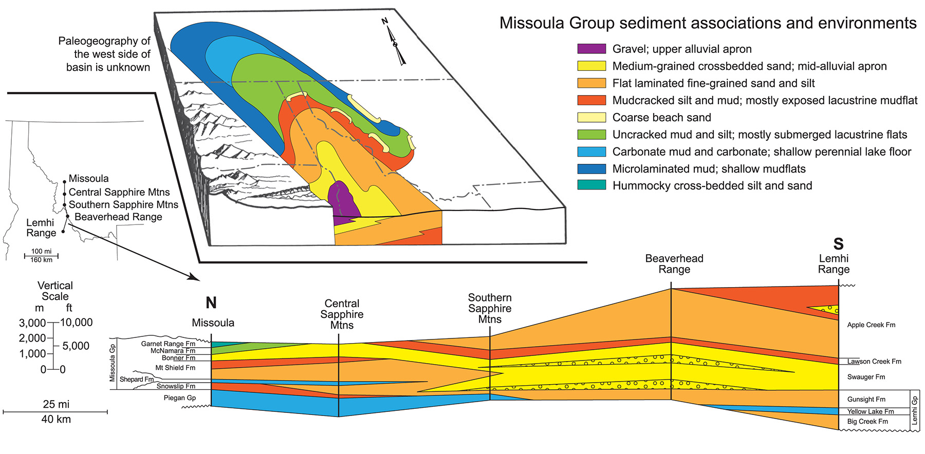
Sedimentology of the Belt Supergroup
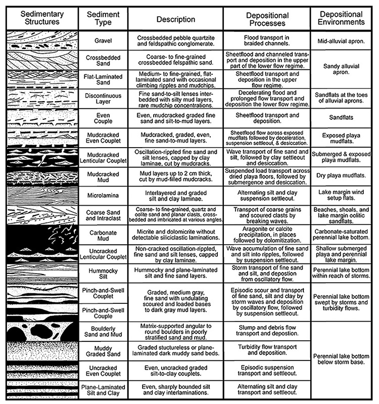
The sedimentary structures preserved in the Belt Supergroup are striking and permit a detailed interpretation of the sedimentology during Belt Supergroup deposition (Winston and Link, 1993). On the other hand, Belt sediments were deposited prior to evolution of land plants and the landscape was likely desolate and different than any modern setting.
Where did all the fine-grained sediment come from?
One extraordinary thing about the Belt Supergroup is that it mainly accumulated in a rapidly subsiding, underfilled sedimentary basin where there was abundant accommodation space for the sediment to aggrade vertically. This basin did not produce the kinds of sedimentary structures that are found in marine shoreface deposits during Paleozoic time, such as erosional surfaces or incised valleys (sequence boundaries) that are related to local and global sea-level changes. Sandstones and mudstones of the Ravalli and Missoula Groups display cyclic aggrading contacts between sedimentation events driven ultimately by floods in large fluvial systems. They do not contain tidal cross bedding, or marine truncation surfaces or incised valleys. Thus, deposition is interpreted to have been largely in a huge lake basin, where accommodation space was not limiting and sediment could build up to create the extraordinarily thick Belt Supergroup.
- Detrital zircon data and measured paleocurrent indicators suggest that the Lower Belt basin received sediment from the east and west (in modern coordinates), including likely from part of the Gawler craton in Australia (Stewart, 2009).
- During the late stages of deposition, detrital zircons indicate a shift to a predominantly southerly source from southwestern Laurentia (Link et al., 2016).
Continue to Module 3 - Rifting and the Passive Margin
References and further reading
Brennan, D.T., Mahoney, J.B., Li, Z.-X., Link, P.K., Evans, N.J., and Johnson, T.E., 2021, Detrital zircon U–Pb and Hf signatures of Paleo-Mesoproterozoic strata in the Priest River region, northwestern USA: A record of Laurentia assembly and Nuna tenure: Precambrian Research, v. 367, p. 106445.
Link, P.K., Stewart, E.D., Steel, T., Sherwin, J.-A., Hess, L., and McDonald, C., 2016, Detrital zircons in the Mesoproterozoic upper Belt Supergroup in the Pioneer, Beaverhead, and Lemhi Ranges, Montana and Idaho: The Big White arc, in MacLean, J.S., and Sears, J.W., eds., Belt Basin: Window to Mesoproterozoic Earth: Geological Society of America Special Paper, v. 522, p. 163–183.
Lonn, J.D., Burmester, R.F., Lewis, R.S., and McFaddan, M.D., 2020, The Mesoproterozoic Belt Supergroup: Montana Bureau of Mines Special Publication, v. 122.
Ross, G.M., and Villeneuve, M., 2003, Provenance of the Mesoproterozoic (1.45 Ga) Belt basin (western North America): Another piece in the pre-Rodinia paleogeographic puzzle: Geological Society of America Bulletin, v. 115, p. 1191–1217.
Stewart, E.D., 2009, Geology of the Allan Mountain Quadrangle, Idaho and Montana, and provenance studies of the Mesoproterozoic Belt Supergroup and Lemhi Group using U-Pb, Hf, and Nd isotopes [M.S. thesis]: Pocatello, Idaho State University, 70 p.
Winston, D., and Link, P.K., 1993, Middle Proterozoic rocks of Montana, Idaho and Eastern Washington: The Belt Supergroup: in Reed, J.C.J., Bickford, M.E., Houston, R.S., Link, P.K., Rankin, D.W., Sims, P.K., and Schmus, W.R.V. eds., The Geology of North America, Precambrian: Conterminous U.S., The Geology of North America, Precambrian: Conterminous U.S., v. C–2, p. 487-517.
Credits
This page was originally created by Lori Tapanila and Paul Link; it was modified and updated by Dave Pearson at Idaho State University.