
Columbia River basalts
The Columbia River basalts were deposited between 17.5 and 6 million years ago and cover an area of approximately 210,000 km2. Five main episodes of volcanism occurred in western Idaho, central and southern Washington, and northern Oregon.
PDF slideshows: Columbia River basalts by Cash and Lewis
The Steens Basalt was deposited first, followed by the Imnaha Basalt, the Grande Ronde Basalt, the Wanapum Basalt, and the Saddle Mountains Basalt. It is believed that the fronts of the lava flows were several stories (approximately 30 meters) high as they flowed from the eruption center at speeds up to three miles per hour (Alt and Hyndman, 1985). These basalts erupted from long fissures in the ground, not from volcanic cones.
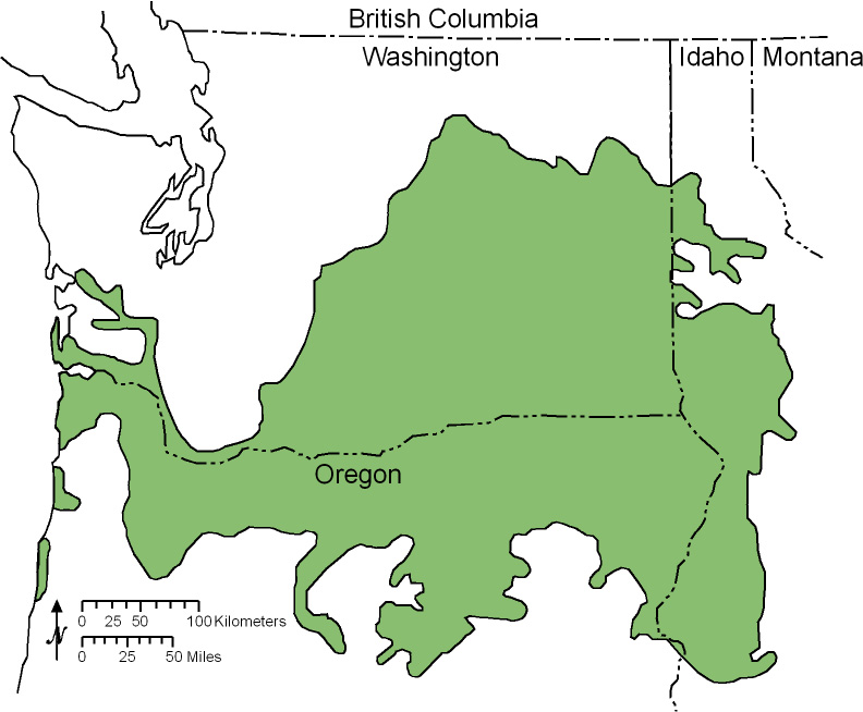
(Above) Map of Columbia River Basalts in the northwestern United States (modified from Alt and Hyndman, 1985).
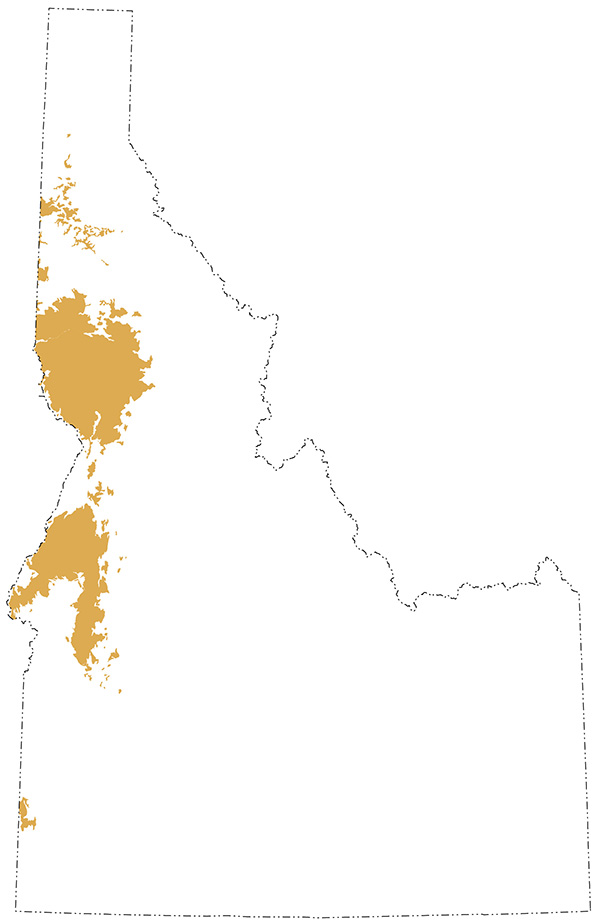
(Above) Exposures of Columbia River basalt rocks in Idaho
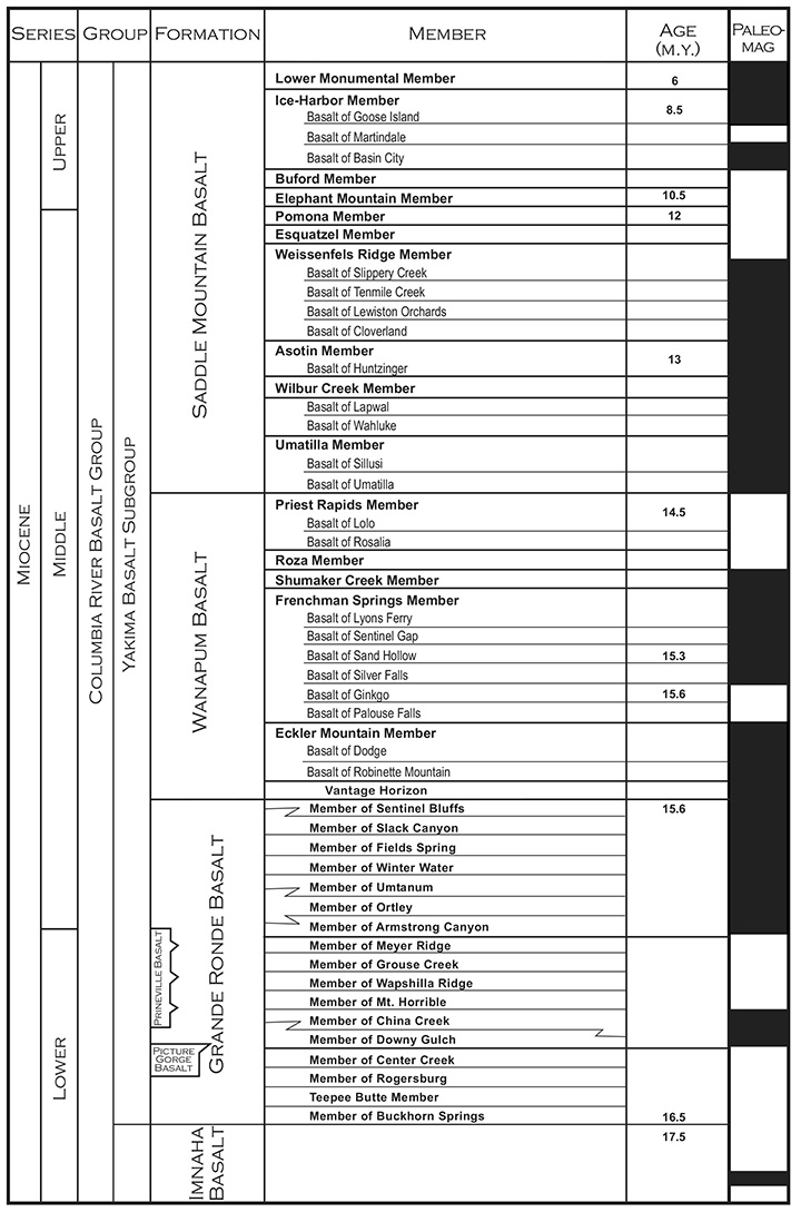
(Above) Stratigraphic column of the Columbia River Basalt. Paleomagnetic data in the right column: black areas indicate a time of normal magnetic polarity whereas white areas indicate a time of reverse polarity (modified from Reidel and others, 2003).
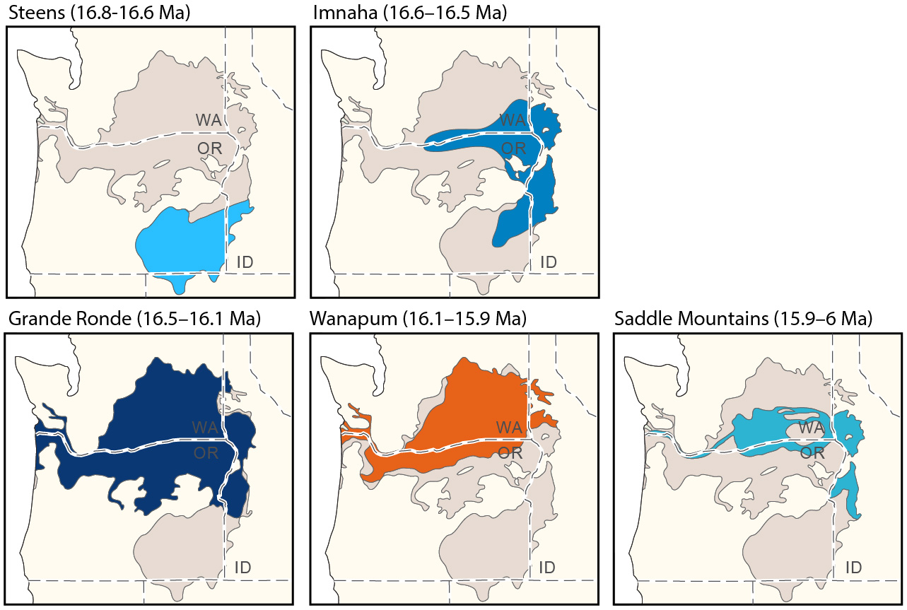
(Above) Maps of different eruptive epidodes of the Columbia River basalt (modified from Link et al., 2021).
The 16.8-16.6 Ma Steens basalts (Kasbohm and Schoene, 2018) are the first of the Columbia River basalts, which are mostly exposed in southeastern Oregon.
The overlying Imnaha Basalts were erupted between 16.6 and 16.5 Ma and are characterized by visible grains of green olivine and greenish-white plagioclase. When it weathers it becomes rounded and smooth. At places in western Idaho, the Imnaha Basalt is 900 meters thick, filling Miocene paleocanyons of the Clearwater River System.
Accounting for approximately 90% of all the basalt in the Columbia River basalts, the overlying Grande Ronde Basalt is the most extensive; covering 163,700 km2. The formation was deposited between 16.5 and 16.1 million years ago and buried many of the older flows. The weight of all the massive basalt caused the crust to subside, forming the Columbia embayment, or basalt-filled basin. The Grande Ronde flows originated in southeastern Washington and northeastern Oregon in the Chief Joseph Dike Swarm. Some dikes are over 7 meters thick. Over 120 flows occurred during this episode, producing tholeiitic basalt with no olivine and very few crystals visible. Glass, plagioclase and augite are the most common minerals in these basalts. When the Grande Ronde Basalt weathers, the basalts often produce sharp columnar jointing patterns that formed as the basalt cooled.
The Wanapum Basalt was deposited between 16.1 and 15.9 million years ago. Although it accounts for only approximately 5% of the total volume of Columbia River basalts, the formation onlapped much of the underlying Grande Ronde basalts. The Wanapum basalts are more silica rich than the older basalts, 58% vs. 56%. The appearance of these basalts varies. Some contain large prisms of pale green plagioclase as well as crystals of glassy olivine while others contain no olivine and only the green plagioclase.
The most recent event in the formation of the Columbia River Basalts was the deposition of the 15.9-6 Ma Saddle Mountains Basalt. These basalts flooded areas where subsidence was occurring due to the weight of the Grande Ronde Basalt. Although these basalts cover a large area, they account for less that 1% of the total volume of basalt and occur as very thin layers of basalt. The Saddle Mountains Basalt is even more silica rich than the Wanapum Basalt.
Eruptive rates
All researchers agree that the volume of lava erupted during the Columbia River basalt episode is truly exceptional. Due to recent improvements in geoscientists' ability to determine the ages of these rocks, workers are also beginning to appreciate how exceptionally high eruptive rates were. For example, Kasbohm and Schoene (2018) showed that up to 83% of the total volume of basaltic volcanism within the Columbia River basalts was erupted in less than ~700,000 years; this may have contributed to an episode of global climate warming called the Mid-Miocene Climatic Optimum.
Additional work on dikes that fed different lava flows within the CRB studied the heating that occurred adjacent to dikes within the ~130 Ma Wallowa batholith. These results suggest that dikes were actively heating their wallrocks for several years during basaltic eruptions (Karlstrom et al., 2019; Biasi and Karlstrom, 2021), which suggests a much faster rate of eruption than previous workers.
Sedimentation in the Columbia River Basalt region
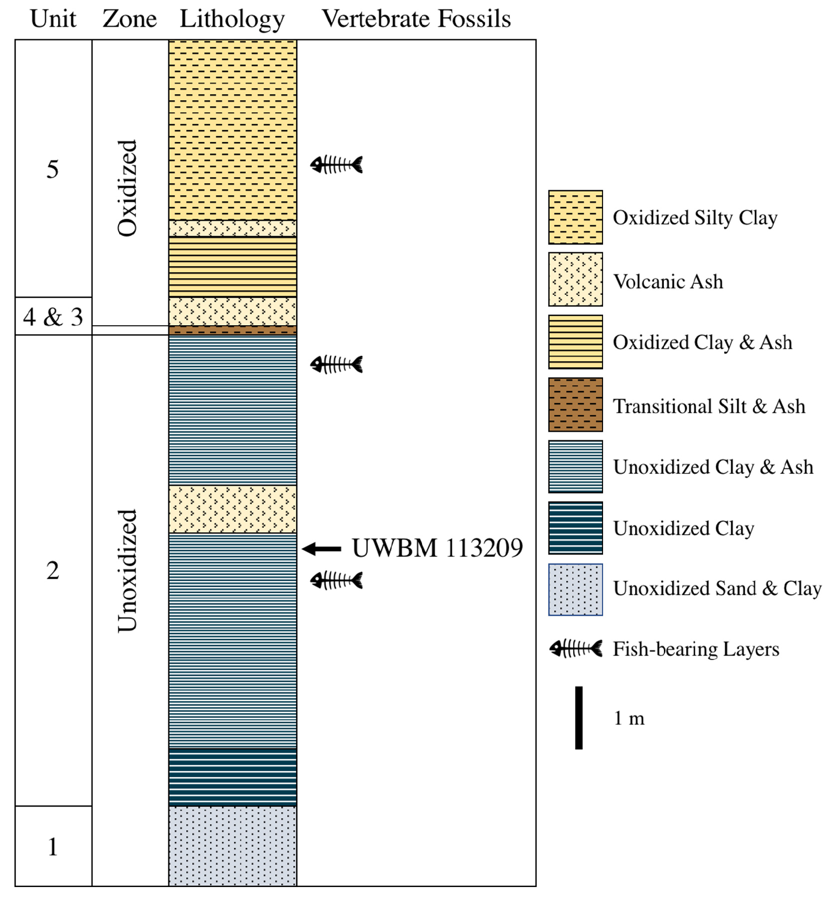
(Above) Stratigraphic column of the Latah Formation near the town of Clarkia in the Idaho panhandle (from Calede et al., 2018).
Drainage patterns on the entire plateau changed because of the Columbia River Basalts. Smaller rivers could not cut through the basalt and many of these smaller rivers were dammed up by the basalt and formed lakes and ponds, such as Clarkia Lake in western Idaho, (Orr and Orr, 2002). These lakes and ponds became prime locations for the deposition of sediments as well as the deposition of plant and animal remains. Many plants, mammals and insects thrived in the areas surrounding these lakes. Soil often formed around the lakes between eruptions. Larger rivers also could not cut through the basalt. However, they re-routed themselves to travel alongside the edge of the basalt flows. The Snake River moved south several times during the formation of the Columbia River Basalts.
Sedimentary basins also formed during this time period. Three formed partially in Idaho; one near what is now Coeur d'Alene, one near Lewiston, and one near Weiser. Slow streams deposited many sizes of sediments into these basins. Volcanic ash from Miocene volcanoes also settled in the basins.
Lava also dammed rivers and created lakes; the most important of these lakes is Clarkia Lake. Clarkia Lake sediments are richly fossiliferous with abundant plant megafossils, insects, fish, mollusks, and freshwater sponges. (A 30 cm by 45 cm by 8 m section contained 10,749 identifiable plant megafossils.) The lake and its deposits formed mainly in the Neogene in central-western Idaho. Most fossils are found in bedding planes within the formation. The sediments are mostly finely laminated clays and silty clays which may indicate lacustrine varves formed seasonally in the lake. Layers of volcanic ash are also present. Most sediment layers fine and lighten in color upward and are capped by a layer of organic rich sediments (Smiley and Rember, 1979).
Continue to Module 11 - Yellowstone and Snake River Plain
References and further reading
Alt, D. and Hyndman, D.W., 1995, Northwest exposures, a geologic story of the northwest, Chapter 34: Floods of Basalt: Mountain Press Publishing Company, Missoula, MT, p. 241-248.
Biasi, J., and Karlstrom, L., 2021, Timescales of magma transport in the Columbia River flood basalts, determined by paleomagnetic data: Earth and Planetary Science Letters, v. 576, p. 117169.
Calede, J.M., Orcutt, J.D., Kehl, W.A., and Richards, B.D., 2018, The first tetrapod from the mid-Miocene Clarkia lagerstätte (Idaho, USA): PeerJ, 6:e4880.
Link, P.K., Willsey, S., Schmidt, K., and Feeney, C.M., 2021, Roadside Geology of Idaho: Mountain Press Publishing Company, Missoula, MT.
Orr, W. N. and Orr, S. L., 2002, Geology of the Pacific Northwest, 2nd Edition, Chapter 10: Columbia River Plateau: McGraw-Hill Higher Education, New York, NY, p. 238-255.
Reidel, S.P. and others, 2003, The Columbia River flood basalts and the Yakima fold belt, in Swanson, T.W. ed., Western Cordillera and adjacent areas: Geological Society of America Field Guide 4, p. 87 – 105.
Smiley, C.J. and Rember, W.C., 1979, Guidebook and road log to the St. Maries River (Clarkia) fossil area of northern Idaho , Idaho Bureau of Mines and Geology Information Circular 33.
Smiley, C.J, and Rember, W.C, 1985, Physical setting of the Miocene Clarkia fossil beds, northern Idaho in Smiley, C.J, ed., 1985, Late Cenozoic History of the Pacific Northwest, interdisciplinary studies on the Clarkia fossil beds of northern Idaho; Allen Press, Lawrence, Kansas, 417 p.Credits
This page was originally created by Kristen Straub and Paul Link, Idaho State University; it was modified and updated by Dave Pearson at Idaho State University.