
Lake Bonneville flood
Lake Bonneville was the largest Pleistocene lake in western North America. It was the predecessor to the Great Salt Lake in the eastern Great Basin. During Pleistocene glaciation, the lake basin filled, covering >50,000 km2 with 10,400 km3 of water before reaching its maximum possible stage governed by Red Rock Pass, the lowest divide separating the basin from the Snake River basin to the north. The lake spilled over at Red Rock Pass about 18,000 years ago and caused megafloods that entered the Columbia River system.
PDF slideshows: Bonneville flood by Paul Link.
History of Lake Bonneville
Ancient Lake Bonneville was located in north-central Utah and was fed by the Bear River, until 14,500 years ago, during the Pleistocene Epoch. Lake Bonneville was the largest stage of the ancient lake that is now the Great Salt Lake. After the Lake Bonneville Flood, the lake fell to the Provo shoreline level.
The fluctuations of the lake level are explained in the History of Lake Bonneville (below) developed by S. Khan and students at the University of Houston.
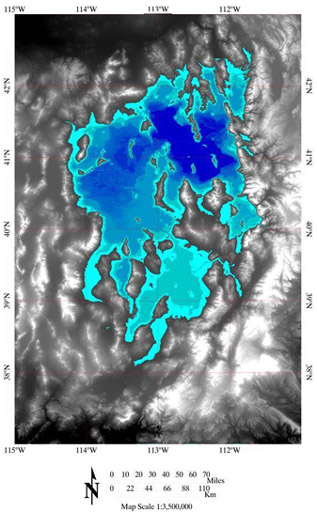
(Above) The map shows all of the lake stages from the past 23,000 years. The levels, from lightest to darkest, are Bonneville, Provo, Stansbury, Gilbert, and the contemporary Great Salt Lake. The chart below shows the changes in lake levels over time.
The history of Lake Bonneville is also the history of the Great Salt Lake. The modern lake is a small residual of Bonneville, a pleistocene lake that at its peak covered 52,000 sq km (32,000 sq mi) in what is now northwestern Utah and Southern Idaho. Several distinct stages have been identified at which lake levels remained constant for periods of one thousand years or more; these are called Stansbury, Bonneville, Provo, and Gilbert. The highest stage, Bonneville, was cut short by a massive flooding event through the Red Rock pass area near Zenda, Idaho, which released about five thousand cubic kilometers of water - the second largest flood in the geologic history of the world.
(Above) Lake levels of Lake Bonneville from 30,000 years ago to Present.
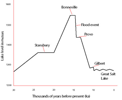
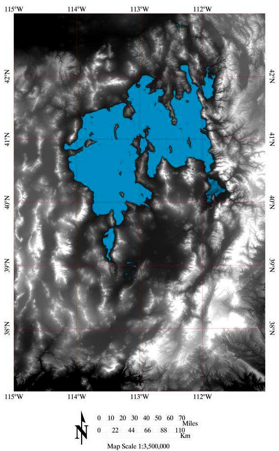
Stansbury level 23-20 ka
The initial advent of drainage into the Bonneville basin was well in progress by about 25 thousand years ago, but stalled out about 23 thousand years ago, apparently due to climate rather than topography. This event created the Stansbury beach at 1372m (4500 ft) above sea level, and held it there for 3000 years. This level covered approximately 9300 square miles.
(Left/Above) The map shows the outline of the lake at the Stansbury level, from 23-20 thousand years ago.
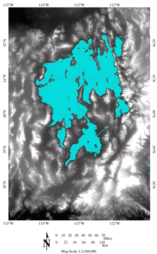
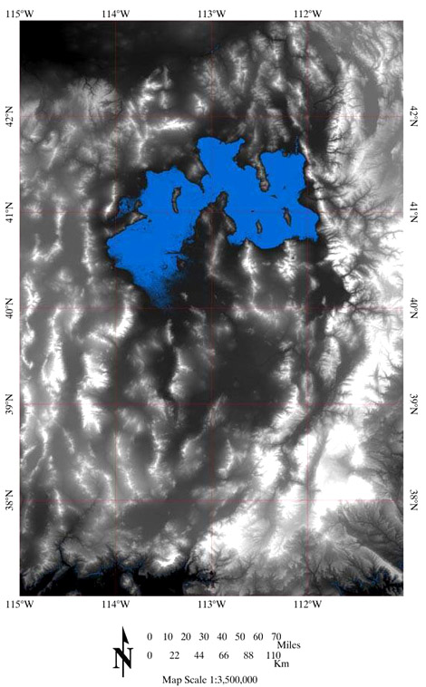
Bonneville level 16 - 14.5 ka
The shoreline levels raised until about 16 thousand years ago when, at 1552m (5090 ft), the water reached the rim of the basin at Red Rock Pass. For roughly a thousand years the lake level oscillated, forming the highest shoreline covering 19,800 square miles. Principle control was probably through overflow at Red Rock Pass, but leakage through the alluvium and karsts through the limestone as well as a balance between precipitation and evaporation stalled the lake level at this stage. Shortly before its break out, a short regression occurred that created the Keg Mountain oscillation. Between 15 to 14 thousand years ago a catastrophic failure of the alluvium fan at Red Rock Pass released a surge of floodwaters and lowered the over all lake level approximately 105m (350 ft.) Isostatic rebound has raised the shoreline left by the Bonneville level unevenly, and its current level varies by 61m (200 ft) of elevation.
(Left/Above) This image shows the size and shape of the lake at the Bonneville stage, about 16 thousand to 14.5 thousand years ago. The red rectangle indicates the location of Red Rock Pass, where the floodwaters escaped.
The Flood Event
Red Rock Pass is a narrow valley just north of Cache Valley and directly south of Downey Idaho. It is bounded by two mountain ranges; the Portneuf to the East and the Bannock to the West. The pass is a tertiary normal faulted graben consisting of tuffaceous fine-grained clastics and carbonates of the Salt Lake formation overlain by unstable Quaternary Alluvial fan gravels carved out by a massive flooding event roughly 14.5 thousand years ago.
During the Quaternary, alluvial fan gravels from the two ranges coalesced to create a saddle shaped dam. The rising Lake Bonneville was halted by this alluvial dam at the Zenda threshold approximately 16 thousand years ago. The threshold was first breached to the east side of Red Rock Pass, at about 14.5 thousand years ago, eroding out the alluvial fan. Its base level was controlled by the resistant karstic limestone of the Blacksmith Formation.
The outflow ultimately slid to the west undercutting the alluvium at the foot of the Bannock and prompting a 17 square kilometer landslide. This landslide was then truncated by the flood causing massive flood deposits of alluvial gravel under what are now Downey and the surrounding valley. From the break point at Red Rock Pass, the flood route flowed into the Marsh Creek Valleys, through the Portneuf Narrows and into Snake River Plain just North of Idaho. From there if followed the Snake River Canyon into Michaud Flats and up to Lewiston, where confirmation of the Bonneville Flood is obscured by the effects of the Missoula Flood.
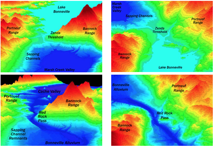
(Above) The two left hand images look down upon Red Rock Pass from the southwest. The two right hand images look generally southward. The upper pair of images are from an elevation model created for the damming event, while the lower pair are from a present-day model for comparison. All model height (relief) has been stretched by a factor of 7. Blue color does not necessarily represent water, but elevation.
Provo level 14.5 – 13.5
As the outlet channel stabilized it cut down through the alluvium to the underlying bedrock. The lake level stabilized when it was even with the resistant rock at an altitude of 1445m (4740 ft) and covered 23,175 sq km (14,400 sq mi.) The lake remained at this level with water flowing out of the basin through Red Rock Pass, into the Snake River and eventually the Pacific Ocean for roughly a thousand years. With the end of the last major ice age, the lack of water flowing into the basin caused the beginning of the gradual decline in the lake level to its current levels.
(Left/Above) This image shows the size and shape of the lake at the Provo stage, about 14.5 thousand to 13.5 thousand years ago.
Gilbert level 11 – 10 ka
Following a 2.5 thousand year period of decline, between 11 and 10 thousand years ago, the lake rose once more to 1295m (4250 ft) above sea level before continuing to decline. This event formed the Gilbert shoreline. This minor rise in lake level covered 10,622 sq km (6,600 sq mi) and marked the end of the Lake Bonneville cycle.
(Left/Above) The Gilbert shoreline, approximately 11 to 10 thousand years ago.
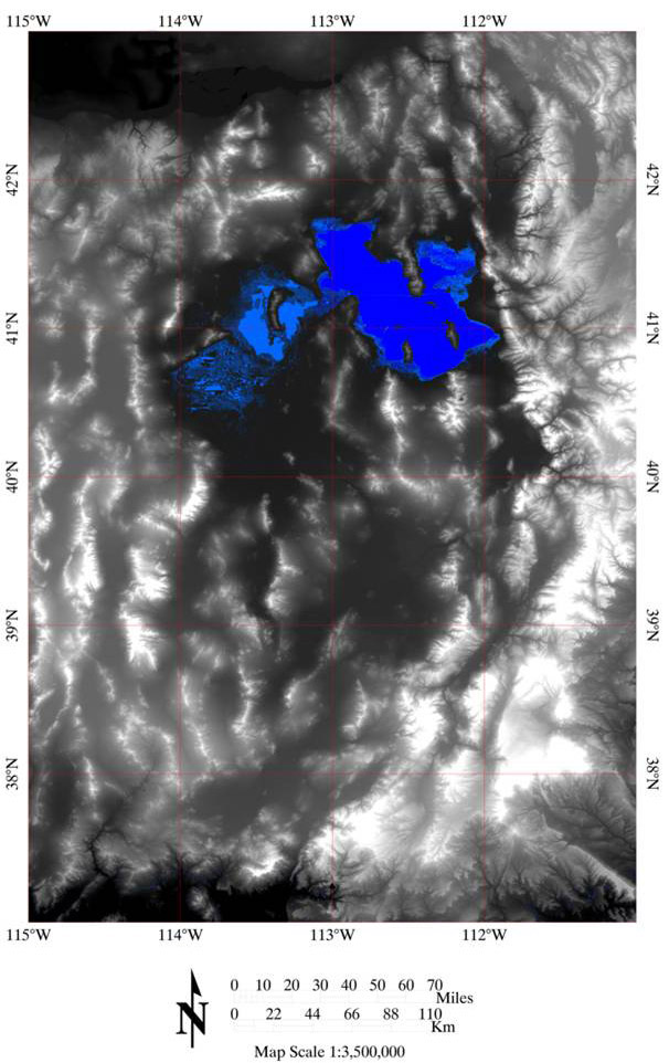
Contemporary - The Great Salt Lake
Since the last Lake Bonneville stage (Gilbert), the Great Salt Lake has fluctuated between lows of 1277m (4191 ft) and highs of 1285m (4217 ft) above sea level. Low levels within the lake have been found by shallow-water sediments in cores from the bed of the lake, and by polygonal networks of giant desiccation cracks which cover extensive areas of the lake bottom. The 1285m high stand level is controlled by a pair of low topographic divides that separate the Great Salt Lake (GSL) and the GSL Desert basin to the west. At the 1285m elevation the area of the GSL increases from its average 4506 square km (2800 sq mi) to 5955 sq km (3700 sq mi.)
Because the GSL basin is topographically closed the only outlet for water when it was at its highest stages was through the Red Rock Pass, now the only outlet is through evaporation.
(Left/Above) This image shows the outlines of the Great Salt Lake at its low of 4191 meters above sea level and high of 4217 meters above sea level, in dark and light blue respectively.
Extent and timing of Lake Bonneville flood
Climate fluctuations were extreme and rapid during Pleistocene time and caused fluctuations in glaciation and flooding of drainage systems during times of glacial melt. At 14.5000 ybp (radiocarbon years before present), Lake Bonneville overfilled and formed a body of water that broke through the rock at Red Rock Pass and flooded much of southern Idaho.
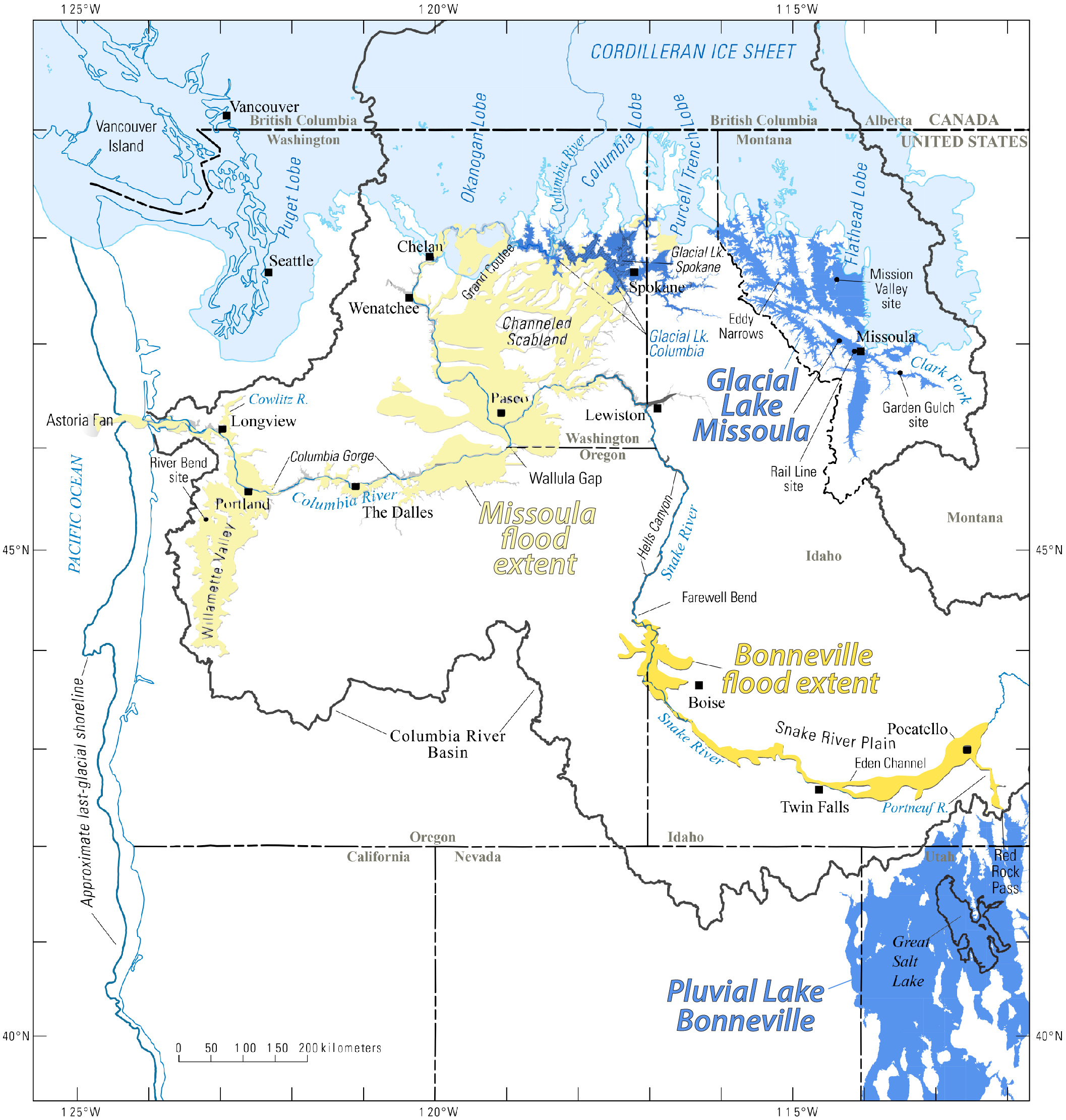
(Above) Map showing the southern extent of the Cordilleran Ice Sheet, including the three lobes, at its maximum during the Pinedale glaciation. Map also shows Glacial Lake Missoula and Lake Bonneville, as well as flood deposits (modified from O'Connor et al., 2020).
The Lake Bonneville flood filled the Pocatello Valley and flowed up through Marsh Valley and then out onto the Snake River Plain. The flood emptied the top 107 meters of water from Lake Bonneville , an estimated volume of 4,750 cubic km of water (Link and Phoenix, 1996). The peak discharge from the Red Rock Pass outlet is estimated to have lasted for about 8 weeks and to have been about 500 times that of the maximum discharge ever recorded from the Snake River at Idaho Falls.
Causes and effects of the Lake Bonneville flood
Several geological and environmental factors likely contributed to the Bonneville Flood. Rapid climate fluctuation during Pleistocene time produced large transgressions and regressions of the Bonneville shore level. Periodic overflow of Lake Bonneville water at Red Rock Pass controlled the maximum height of the shore line at 1550 m (Link et al., 1999). These events were apparently non catastrophic through most of the history of Lake Bonneville.
Subsidence of the Snake River Plain in the wake of the Yellowstone Hotspot produced changes in regional drainage patterns and volcanic eruptions produced natural dams that diverted steam drainages (Link et al., 1999). The Bear River previously flowed north into the Snake River. At ~50 ka, the Bear River cut through the Oneida Narrows , near the town of Thatcher (Figure 3) and diverted to the Bonneville basin. This increased the inflow of water to the basin by ~33% (Link et al., 1999).
Subsurface leakage of water at Red Rock Pass through alluvial fan gravels and karstic limestone initiated a catastrophic slope failure and emptied water from Lake Bonneville to the level of the Lake Provo shoreline (Link et al., 1999). The excess water from Lake Bonneville flooded the Marsh and Portneuf Valleys before emptying into the Snake River. Evidence of the flood is found as far away as Lewiston, Idaho (Link et al., 1999).
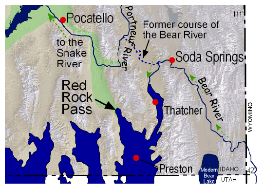
(Left/Above) Modern paths of rivers and the ancient pathway of the Bear River, before it began to flow southward. Figure redrawn from Link and Phoenix, 1996.
The Lake Bonneville Flood left behind many scabland features such as dry waterfalls, alcoves, scoured bedrock surfaces, and boulder bar accumulations (Link and Phoenix, 1996). Evidence of this is seen in the Pocatello area; the removal of the Portneuf Valley basalt from the Portneuf Narrows area and the deposition of rounded basalt boulders (up to 3.5 meters in diameter) in the adjacent basin are prime examples. Other spectacular examples of Bonneville Flood features are the Snake River Canyon, alcoves, and waterfalls (e.g. Shoshone Falls) at Twin Falls and the "watermelon" boulders near Hagerman.
Continue to Module 15 - Snake River Plain aquifer
References
Currey, D.R., Atwood, G., and Mabey, D.R., 1984, Major levels of Great Salt Lake and Lake Bonneville: Utah Geological and Mineral Survey Map 73.
Digital Atlas of Idaho, http://imnh.isu.edu/digitalatlas, managed by Idaho State University Department of Geosciences and hosted by the Idaho Museum of Natural History, Pocatello, ID.
Link, P.K., Kaufman, D., and Thackray, G.D., 1999, Field Guide to Pleistocene Lakes Thatcher and Bonneville and the Bonneville Flood, Southeastern Idaho, in Hughes, S.S. and Thackray, G.D., eds., Guidebook to the Geology of Eastern Idaho: Idaho Museum of Natural History, Pocatello, p. 251-266.
Malde, H.E., 1968, The catastrophic late Pleistocene Bonneville Flood in the Snake River Plain, Idaho: U.S. Geological Survey Professional Paper 596, 52 p.
O'Connor, J.E., 1993, Hydrology, hydraulics, and geomorphology of the Bonneville flood: Geological Society of America Special Paper 274, 83 p.
Credits
This page was originally created by Laura DeGrey-Ellis, Myles Miller, and Paul Link, Idaho State University; it was modified and updated by Dave Pearson at Idaho State University.