
Palouse and glacial Lake Missoula
The Pleistocene Epoch included a series of glacial advances that began about 2.5 million years ago and lasted until about 10,000 years ago. During this time, cyclic climate fluctuations caused glaciers and continental-scale ice sheets to advance and retreat into the mid-latitudes of the northern hemisphere. The formation of glacial Lake Missoula occurred during the Pinedale (Wisconsinan) glaciation, which began 22,000 years ago and lasted until 13,000 years ago. After the Pleistocene glaciers retreated, extensive wind-blown silt, known as loess, was deposited in the Idaho panhandle forming the Palouse landscape. Significant loess was also deposited in southeastern Idaho.
PDF slideshows: Studies & Graphics of the Missoula Flood by Matthew Wilson and Palouse landscape by Jim Cash.
The Pleistocene ice age
In Pleistocene time, vast ice caps covered much of North America and Eurasia; As much as a third of Earth's land surface was periodically covered in ice during this time (Ray, 1993). Four major glacial periods are recognized in North America: the Nebraskan, Kansan, Illinoisan, and Wisconsinan glaciations. Minor fluctuations occurred within each period. Interglacial periods were periodically warmer than the present climate (Ray, 1993). Major interglacial periods include the Aftonian, Yarmouth, and Sangamon periods. The formation of glacial Lake Missoula occurred during the Pinedale (Wisconsinan) Glaciation. More information about Pleistocene glaciations in Idaho can be found here.
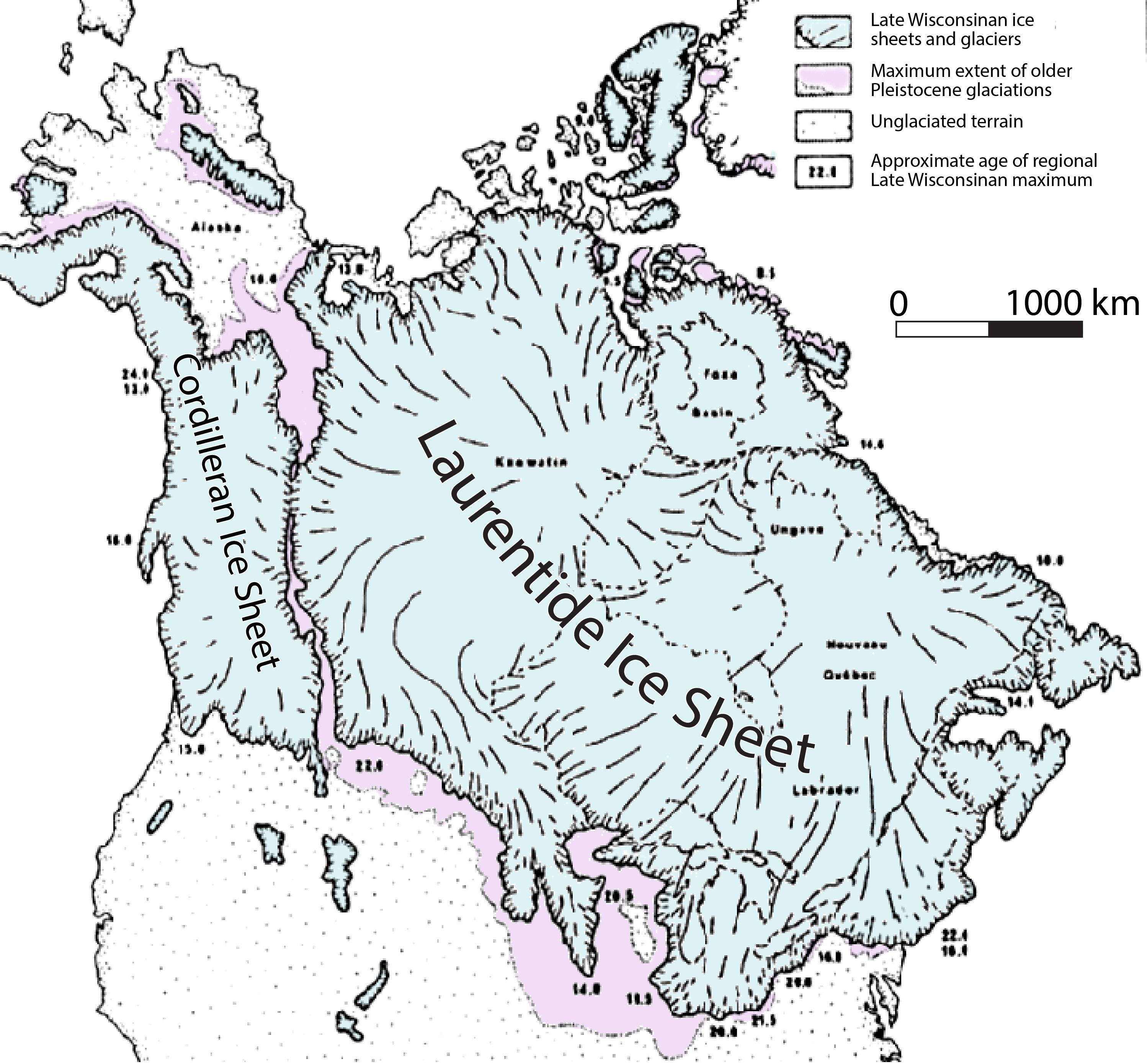
(Above) Late Wisconsinan extent of glacial ice in North America. The Sawtooth Mountains represent the middle small patch of ice in the northern Rocky Mountains (Thackray et al., 2004, and Sherard, 2006).
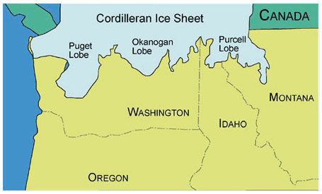
(Above) Map showing the extent of the Cordilleran Ice Sheet, including the three lobes, at its maximum during the Pinedale glaciation.
During the Pinedale Glaciation, Canada and the northern United States were glaciated by two large continental ice sheets. The Cordilleran Ice Sheet, the smaller sheet, covered southwestern Canada and the northern areas of Washington, Idaho, and Montana. At times, the Cordilleran Ice Sheet coalesced with the eastern Laurentide Ice Sheet (Booth et al., 2003). It was approximately 1150 meters thick and contained three main lobes. The western lobe was called the Puget Lobe and scoured out Puget Sound in northwestern Washington. The central lobe was called the Okanogan Lobe. It blocked the Columbia River at the location of the current Grand Coulee Dam, forming Glacial Lake Columbia. The Purcell Trench Lobe, the eastern lobe, dammed the Clark Fork River several times to form glacial Lake Missoula. Maximum volume for lake Missoula has been estimated to be as much as 2500 km3 (Booth, et al., 2003).
Palouse landscape of northern Idaho
North of Lewiston, toward Couer d 'Alene, the Miocene Columbia River basalts are mantled with windblown silt, known as loess (Loess is a geologically recent deposit of silt or material which is usually yellowish or brown in color and consisting of tiny wind deposited particles). Most of this was deposited after the Pleistocene glaciers receded.
The soil is rich in nutrients derived from the basalt from which it was eroded. With abundant winter moisture in north Idaho, the area is a rich winter wheat growing area. The green grain fields mantle the gentle wavy topography, creating a gentle and charming landscape.
The loess blanket is not of even thickness, as it accumulated more thickly in dune shaped landforms. Many of these are influenced by underlying hills and stream valleys that had been eroded into the basalt flows.
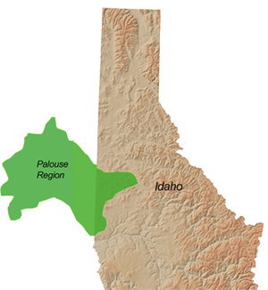
(Above) The Palouse region of northern Idaho and eastern Washington.
Ancient Lake Missoula and the Missoula ice age floods
Lake Missoula formed behind an ice dam, which formed when a finger of the Purcell lobe of the Cordilleran Ice Sheet advanced into the Idaho Panhandle in the area which now is occupied by Pende Orielle Lake. This large ice dam blocked the Clark Fork River, allowing water to build up behind it, extending eastward some 200 miles into western Montana. Lake Missoula was as deep as 2000 feet at the dam, and held more than 500 cubic miles of water at its fullest. This is more water than Lake Erie and Lake Ontario combined.
Water pooled behind the ice dam until a critical point of water height and pressure was reached. Eventually, the ice dam of Lake Missoula began to fail when hydrostatic pressure wedged the water between the ice and the rock. This continued until the ice could become buoyant and the water could flow through subglacial tunnels. When the roof of the ice tunnels collapsed the dam failed and suddenly Lake Missoula flooded. This happened at a water depth of about 2000 feet, when the dam failed catastrophically. Water from Lake Missoula burst through the base of the dam, at a rate of ten times the combined flow of all the rivers in the world! Calculated flood speeds reached almost 65 miles per hour. At this rate, the lake would have drained in only a couple of days.
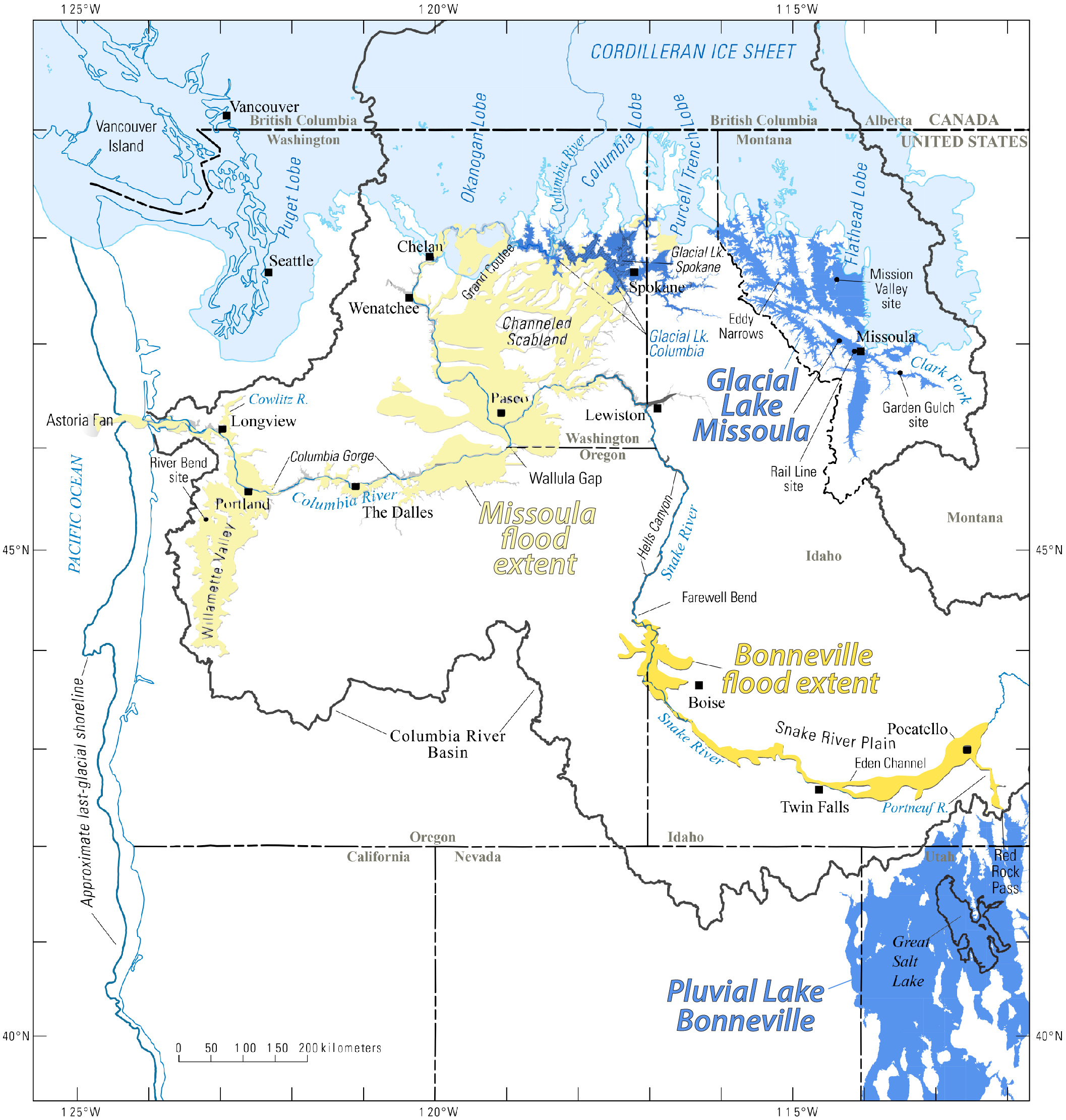
(Above) Map showing the southern extent of the Cordilleran Ice Sheet, including the three lobes, at its maximum during the Pinedale glaciation. Map also shows Glacial Lake Missoula and Lake Bonneville, as well as flood deposits (modified from O'Connor et al., 2020).
Floodwater, ice, and glacial debris thundered west through the panhandle of northern Idaho, and then west and south through eastern and central Washington, widening and deepening the Columbia River Gorge, as they passed. The floodwater followed and deepened the Columbia River channel until it became restricted at a narrow gap near Vancouver, Washington. Here, the flood spilled southward into Oregon's Willamette Valley, and formed a lake that extended as far south as Eugene, Oregon. Finally, back along the path of the Columbia River, the floodwaters made their way into the Pacific Ocean at the mouth of the Columbia River, having travelled a total of 430 miles.
Once the initial ice dam formed and subsequently failed, continued southward glacial advance of the Cordilleran Ice Sheet caused the ice dam to return, and Glacial Lake Missoula to fill, resulting in another flooding event. Over an estimated 2,500 years the sequence of the ice dam forming, the lake filling, the dam failing, and catastrophic flooding, was repeated dozens of times. This collective sequence is what is considered the "Ice Age Floods".
Lasting effects of the Missoula ice age floods
The floods of Glacial Lake Missoula left lasting scars on the landscape. The floods had both erosional and depositional features.
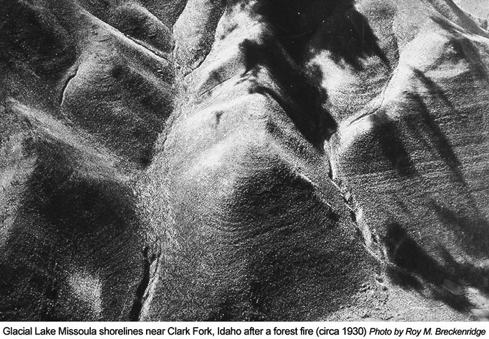
When Lake Missoula was filled, waves along the shore eroded away at the surrounding mountains. Paleoshorelines are carved out of the hillside just outside of Missoula, Montana. The highest shorelines are found at 4200 feet elevation, which would drown the city of Missoula underneath approximately 2000 feet of water.
The flood waters of Lake Missoula also created giant gravel ripple-marks on the Camas Prairie in northwestern Montana. These ripple marks are found on the bottom of what was once Glacial Lake Missoula. These ripple marks are almost 50 feet high and have a wavelength of almost 500 feet. Ripple marks of such gigantic proportions could only have been made by incredibly powerful currents over the lake bottom.
(Above) Giant ripple marks produced by the Missoula Flood. For more information, see here.
Other depositional features of the Lake Missoula Flood include huge bars of current-transported debris and “erratic boulders”. Massive boulders embedded in the Cordilleran Ice Sheet were carried with the flood when the dam failed. Boulders which travelled from Montana and British Columbia can be found along the flood's path even into the Willamette Valley.
As the floods thundered through the Columbia Plateau of eastern and central Washington, they scoured away much of the landscape by stripping away topsoil, picking apart the bedrock, and carving an immense channel system into the land. This area is the famous Channeled Scablands, one of the largest flood-scarred landscapes on earth. Much of the bedrock of this land is the Columbia River Basalt. This basalt contained fractures which provided areas of easy erosion for the floodwaters.
The main features of the Scablands include an eroded, interconnected network of streamlined loess islands, flood channels, coulees, cataracts, and plunge pools, which have been scoured into the basalt. Also worth noting are the giant water falls which were produced by the flood, such as Grand Coulee, Dry Falls, and Palouse Falls. Dry Falls is the largest waterfall in North America, although water does not flow through it anymore. Compared to Niagara Falls, Dry Falls is about 3 times as wide and 2 and a half times as high.
Continue to Module 14 - Lake Bonneville flood
Websites
The Ice Age Flood Institute: https://iafi.org
Montana Natural History Center: http://www.glaciallakemissoula.org/story.html
U.S. Geological Survey: http://volcanoes.usgs.gov/observatories/cvo/Historical/LewisClark/Maps/map_missoula_floods.shtml
"The Missoula Flood", by Keenan Lee Colorado School of Mines, 2009: http://inside.mines.edu/UserFiles/File/Geology/Missoula.pdf
References
Booth, D.B., Troost, K.G., Clague, J.J., and Waitt, R.B., 2003, The Cordilleran Ice Sheet: Developments in Quaternary Science, v. 1, p. 17-43.
Breckenridge, Roy M., 1989, Lower Glacial Lakes Missoula and Clark Fork Ice Dams, in Breckenridge, Roy M., editor, Glacial Lake Missoula and the Channeled Scabland: Missoula, Montana to Portland, Oregon: American Geophysical Union, 28th International Geological Congress, Field Trip Guidebook T310, pp. 13-21.
Breckenridge, Roy M., 1989, Pleistocene Ice Dams and Glacial Lake Missoula Floods in Northern Idaho and Adjacent Areas inChamberlin, V.E., Breckenridge, R.M., and Bonnichsen, Bill, eds. Guidebook to the Geology of Northern and Western Idaho and Surrounding area: Idaho Geological Survey Bulletin 28, pp. 5-16.
Carrara, Paul E., Kiver, Eugene P., and Stradling, Dale F., 1996, The Southern Limit of Cordilleran Ice in the Colville and Pend Oreille Valleys of Northeastern Washington during the Late Wisconsin Glaciation. Canadian Journal of Earth Sciences. V. 33, p. 769-778.
Chambers, Richard L., 1984, Sedimentary Evidence for Multiple Glacial Lakes Missoula. Montana Geological Society, Field Conference Northwestern Montana, pp. 189-199.
Lee, Keenan, Professor Emeritus, Department of Geology and Geological Engineering, Colorado School of Mines. Thanks for the many pictures featured in the slideshow pdf at the beginning of this module.
National Park Service, 2001, Ice Age Floods Study of Alternatives and Environmental Assessment: Following the pathways of the Glacial Lake Missoula Flood: Jones and Jones, Architects and Landscape Architects, Seattle, Washington - http://www.nps.gov/iceagefloods/.
O’Connor, J.E., Baker, V.R., Waitt, R.B., Smith, L.N., Cannon, C.M., George, D.L., and Denlinger, R.P., 2020, The Missoula and Bonneville floods—A review of ice-age megafloods in the Columbia River basin: Earth-Science Reviews, v. 208, p. 103181.
Ray, L.L., 1993, The Great Ice Age: U.S. Geological Survey, General Interest Publications of the U.S. Geological Survey, 1993-352-783, 15 p.
Thackray, G.D., Lundeen, K.A., and Borgert, J.A., 2004, Latest Pleistocene alpine glacier advances in the Sawtooth Mountains, Idaho, USA: Reflections of midlatitude moisture transport at the close of the last glaciation: Geology, v. 32; no. 3; p. 225-228.
Waitt, Jr., Richard B., 1985, Case for periodic, colossal jökulhlaups from Pleistocene glacial Lake Missoula. Geological Society of
Credits
This page was originally created by Laura DeGrey-Ellis and Paul Link, Idaho State University; it was modified and updated by Dave Pearson at Idaho State University.