
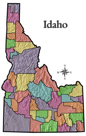
Idaho Maps
Geologic Maps of Idaho
Maps are available by county.
|
List of Idaho Counties: |
 |
|
| Ada Adams Bannock Bear Lake Benewah Bingham Blaine Boise Bonner Bonneville Boundary Butte Camas Canyon Caribou Cassia Clark Clearwater Custer Elmore Franklin Fremont |
Gem
|
|
|
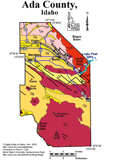
Ada CountyAda County, Idaho's most populous county, has relatively simple geology, compared to some much more sparsely populated areas. On the northeast is the Cretaceous Idaho batholith, home to Bogus Basin ski area. The batholith forms a mountainous area uplifted on south-dipping normal faults which form the northeast margin of the western Snake River Plain. In the Boise foothills are a complex assemblage of sandstones and lake beds formed on the edges and within Lake Idaho in the last 10 million years. The Table Rock Sandstone, quarried since the mid 1800s belongs to these strata. The city of Boise lies in the alluvial valley of the Boise River, which joins the Snake River on the Oregon border, south of Nyssa. A series of northwest striking normal faults cuts Ada County, part of the western Snake River Plain graben. On the south are extensive Quaternary gravel deposits that overlie Quaternary basalt. Recent cinder cones line the Snake River near Swan Falls. P.K. Link, 9/02 |
|
 |
|
|||||||||||||||||||||||||||||||||||||||||||||||||||||||||||||
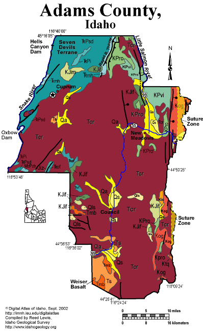
Adams CountyAdams County lies mainly west of the Idaho Suture zone, and is underlain by accreted terrane rocks covered by Miocene Columbia River basalt flows. The suture zone runs east of New Meadows. East of the suture are Cretaceous tonalites of the Idaho batholith. West of the suture are diverse Paleozoic and Mesozoic metavolcanic and metasedimentary rocks that were accreted to North America in the Early Cretaceous. The Rapid River thrust is one of the bounding faults between these subducted terranes. . The Snake River in Hells Canyon forms the western boundary of the state and Adams County. The geology of the region between Riggins and Boise to the south reflects a long history of plate boundary interactions and terrestrial responses. Exposed along this route is the eastern edge of the Miocene Columbia River Basalt and associated sedimentary units, the western edge of the extensive plutonic rocks that comprise the late Cretaceous Idaho Batholith, and metamorphosed sedimentary and volcanic rocks of the Jurassic Seven Devils group. During the Jurassic, an oceanic trench formed off the western margin of North American near the present western Idaho border. North America was moving west, away from the mid-Atlantic oceanic ridge. As the North American continental plate moved westward, the Pacific oceanic plate slid beneath it, and thus beneath the location of the future Idaho. Riding on top of the Pacific oceanic floor were numerous island arcs that eventually were emplaced onto the western margin of North America - prime examples of these emplaced volcanoes are the Seven Devils along Hells Canyon. These rocks are visible in Hells Canyon, along US Hwy 95 outside of Riggins, and along State Hwy 55 and US Hwy 95 near New Meadows. Miocene lacustrine and fluvial rocks are found in the southwest corner of the county south of Council. The largest area of outcrop in the county is underlain by Miocene Columbia River basalt flows. These are visible along US Hwy 95. They were erupted from fissure eruptions. The Columbia River basalt flows dammed streams and sedimentary units were deposited in the heads of valleys as the result of stream blockage. Excellent discussion of the geology of this area is found in Orr, W.N., and Orr, E.L., 2002, Geology of the Pacific Northwest, 2nd ed., McGraw Hill Pubs., p. 138-159. Good information is also contained in Alt, D. D., and Hyndman, D.W., 1989, Roadside Geology of Idaho, Mountain Press, Missoula, 393 p.
Tamra Schiappa and P.K. Link, 10/02 |
 |
|
|||||||||||||||||||||||||||||||||||||||||||||||||||||||||||||||||||
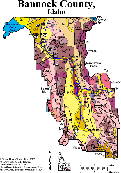
Bannock CountyBannock County straddles the boundary between the Basin and Range, Idaho-Wyoming thrust belt, and Snake River Plain. There are extensive discussions of the geology of Bannock County, including Marsh Valley and Lava Hot Springs in Rocks, Rails and Trails. Bannock County contains folded and thrust-faulted Neoproterozoic and Paleozoic strata in the Bannock and Portneuf Ranges. The intervening Marsh Valley is a Miocene to recent feature, bounded by a normal fault on the east side. The Basalt of Portneuf Valley flowed down the Portneuf River path about 600,000 years ago, and now forms inverted topography in the middle of Marsh Valley. The Lake Bonneville flood broke out at Red Rock Pass in southern Bannock County about 14,500 years ago and flowed north through Marsh Valley and Portneuf Narrows before is spread out in the Pocatello area as it emptied onto the Snake River Plain. Flood boulders are distinctive landscape elements in the Pocatello and Chubbuck areas. See Geology and regional sections of Rocks, Rails and Trails. P.K. Link, 10/02 |
 |
|
|||||||||||||||||||||||||||||||||||||||||||||
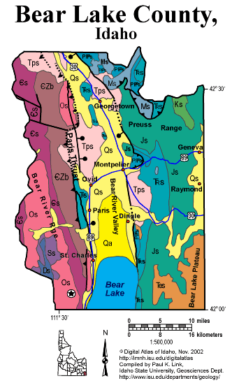
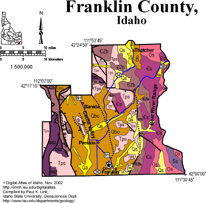
Bear Lake CountyIn Idaho's southeast corner, Bear Lake County is with both the Idaho-Wyoming thrust belt and the Basin and Range province. Drilling for oil was big news here in the late 1970s and 1980s, and it will happen again. Rich phosphate ore of the Phosphoria Formation allowed development of mines in Georgetown, Paris and Montpelier through the 20th century. For more detail on the geology of Bear Lake County see the text from Rocks, Rails and Trails Also see the Fortsch and Link field trip guide in Geologic Guidebook to eastern Idaho. P.K. Link 10/02 |
 |
|
|||||||||||||||||||||||||||||||||||||||||
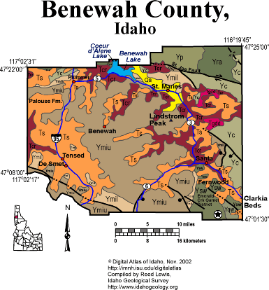
Benewah CountyThis diverse county has rolling Palouse on the west, and foothills and steep forested mountains on the east. The mountains are underlain by Mesoproterozoic Belt Supergroup, with the Emerald Creek mining district in the extreme southeastern corner of the county south of Fernwood found in metamorphic rocks of the middle-Belt Wallace Formation. Miocene Columbia River basalts cover the low farming country in the western county and up the St. Maries river to Clarkia. Lacustrine and river deposits were deposited in valleys that had been dammed up by basalt lava flows. The world famous Clarkia fossil locality formed this way. The St. Joe fault, and Eocene feature related to continental extension and development of metamorphic core complexes runs eastward through the northeast corner of the county, north of St. Maries. Beautiful Benewah Lake and the Coeur d'Alene river make a vacation paradise, but heavy metals in mine waste along the river raise environmental concerns. A small area southeast of St. Maries is underlain by Eocene granodiorite. The Coeur d'Alene Indian Reservation headquarters is at Plummer in the northwestern part of the county. Written by P.K. Link, 9/02 |
|
|
|||||||||||||||||||||||||||||||||||||||||||||||||||||||||
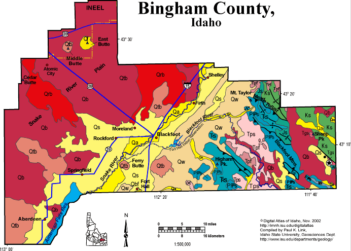
Bingham CountyBingham County covers a vast area, much of it on the Snake River Plain and the foothills of the Blackfoot Mountains on the east. Irrigated farms on both sides of the Snake River make Bingham County and Blackfoot the center of Idaho potato production. Beyond the irrigated farms to the northwest is the sagebrush desert of the Snake River Plain and the area around Atomic City, where dryland wheat farming was attempted in the 1920s. In the northwestern panhandle of the county is a portion of the Idaho National Engineering and Environmental Laboratory, and two of the three buttes, landmarks on the Snake River Plain. Both Middle Butte and East Butte are rhyolite domes, but Middle Butte has not breached its Pleistocene basalt cap. In the southeast of the county, in the hanging wall of the Meade thrust fault, near Mt. Taylor, is phosphate mining country, including the now-closed Gay Mine, on the Fort Hall Indian Reservation. See Root Hog, Blackfoot, and regional geology text from Rocks Rails and Trails. Also see Hughes et al. and McCurry et al. field trip in Guidebook to the Geology of Eastern Idaho. P.K. Link, 10/02 |
|
|
|||||||||||||||||||||||||||||||||||||||||||||||||
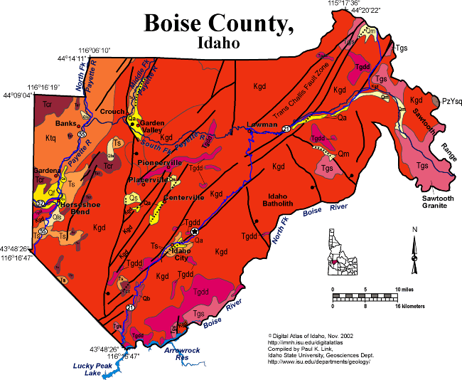
Boise CountyBoise County contains a huge area of the central Idaho Mountains between Ada County and the city of Boise and the Sawtooth Mountains on the east. This country is drained by the Payette and Boise Rivers, Grimes Creek and Bear Valley Creek. Most of the area is underlain by Cretaceous granodiorite of the Idaho batholith. Eocene intrusions are present in the Sawtooth Mountains on the east and in the Idaho City area. Near Idaho City are extensive placer gold workings from the 19th century. Mineralization was along a northeast trending fault zone associated with the Trans Challis fault zone (Great Falls lineament). A north-tending Basin and Range fault, down on the east bounds the system of northeast-striking trans-Challis faults. In the western part of the county, west of Horseshoe Bend on the Payette River is tonalitic intrusive rock of the Idaho batholith, and Miocene Columbia River basalt in the valleys. This basalt flowed north east, or up the valleys from sources to the west in Oregon and westernmost Idaho. Horseshoe Bend is the site of recurrent landslides in Miocene sedimentary rocks of the Payette Formation. These landslides caused rerouting of highway 55 to avoid the active scarps. P.K. Link, 10/02 |
 |
|
|||||||||||||||||||||||||||||||||||||||||||||||||||||||||||||||||||||
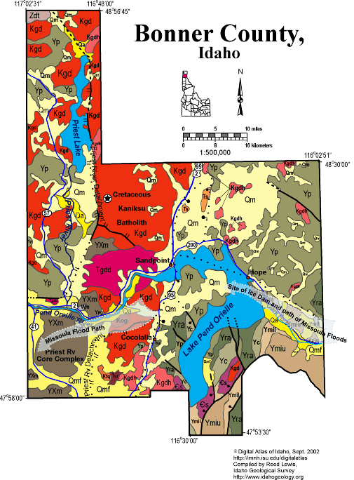
Bonner CountyThe northern and western parts of the county, west of Sandpoint contain the Priest River metamorphic core complex, containing highly metamorphosed rocks of Proterozoic age. The detachment fault which bounds the core complex runs north along the east side of Priest Lake.Cretaceous intrusive rocks of the Kaniksu batholith (part of the Idaho batholith complex) are found both above and below the detachment fault. Eocene granodiorite intrusive rocks are also found in the center of the metamorphic core. The complex represents recurrent Eocene to Recent uplift. In the eastern part of Bonner County relatively low-grade metasedimentary rocks of the Mesoproterozoic Belt Supergroup make up the mountains east of Lake Pend Oreille and along the Montana border. Southeast of Lake Pend Oreille is a small area underlain by Cambrian limestones similar to those mined for lead, zinc and gold near Metaline Washington. The Lake Missoula flood broke out of the Clark Fork Canyon in the eastern Bonner County about 16,000 years ago, with the ice dam spanning the eastern bays of Lake Pend Oreille. The flood broke out to the south and west of Lake Pend Oreille as it flowed into Rathdrum Prairie and the Spokane River. Written by P.K. Link, 9/02 |
 |
|
|||||||||||||||||||||||||||||||||||||||||||||||||||||||
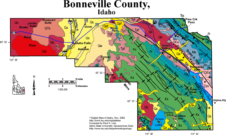
Bonneville CountyBonneville County covers a huge area in eastern Idaho, spanning from the Snake River Plain on the west to the Wyoming border on the east. The horseshoe path of the Snake River is mainly within the county as the river exits the Grand Canyon of the Snake at Alpine Wyoming, and flows north through Palisades Dam and Swan Valley, all within the Miocene to Recent Grand Valley graben. The populated irrigated areas along the Snake River near Idaho Falls hold almost all of Bonneville County's residents, but the nearly empty back county contains beautiful forested mountains on the east and wide open sagebrush desert on the west. The eastern part of the county, including the Caribou and Snake River ranges, is in the Idaho-Wyoming thrust belt, with the Absaroka thrust cropping out about half way up highway 31 toward Pine Creek Pass. This regional structure puts Paleozoic on Mesozoic rocks. Numerous folds are found in Mesozoic rocks in the Caribou Range, in the hanging-wall of the Absaroka thrust fault, and on the west side of the Grand Valley graben. Grand Valley is a Miocene to Recent feature. The main, Grand Valley fault is on the east side. A subsidiary fault, the Snake River fault, is on the west side, west of Swan Valley. In the southwest of the county is the Grays Lake lava field, filled with Pleistocene basalts of the Willow Creek volcanic field, and now covered with the shallow waters of Grays Lake, a national wildlife refuge. For more information see the Idaho-Wyoming thrust fault text from Rocks, Rails and Trails. P.K. Link, 10/02 |
 |
|
|||||||||||||||||||||||||||||||||||||||||||||||||||
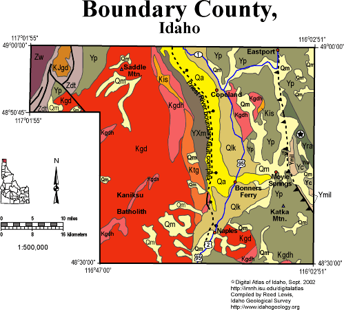
Boundary CountyBoundary County lies at the north end of the Idaho panhandle, and borders Canada. The western portion of the county is part of the Priest River uplift, exposing Cretaceous granitic rocks of the Kaniksu batholith, that intrude Mesoproterozoic Belt Supergroup, and overlying Neoproterozoic Deer Trail and Windermere groups and Cambrian rocks. A small Jurassic or Cretaceous granodiorite intrudes the Deer Trail Group in the northwestern part of the county. This intrusive is associated with accretion of rocks in British Columbia known as the Kootenay arc, a possible island-arc terrane. The eastern portion of the county, east of the east-dipping normal fault that bounds the Priest River core complex uplift, contains Belt Supergroup with small Cretaceous intrusions. A west-dipping thrust fault runs northwest-southeast, through Eastport, and formed during Cretaceous crustal shortening. Bonners Ferry, Eastport, and most of the habitable ground is found on the flat valley of the Kootenai and Moyie rivers, which flow north into Canada before joining the Columbia, whose course bends south and returns to the USA in eastern Washington. A glacial lake, dammed by piedmont ice to the north, occupied this long-north-trending valley, and so fine-grained lake beds underlie much of the Kootenai Valley. P.K. Link, 9/02 |
|
|
|||||||||||||||||||||||||||||||||||||||||||||||||||||||||||||||
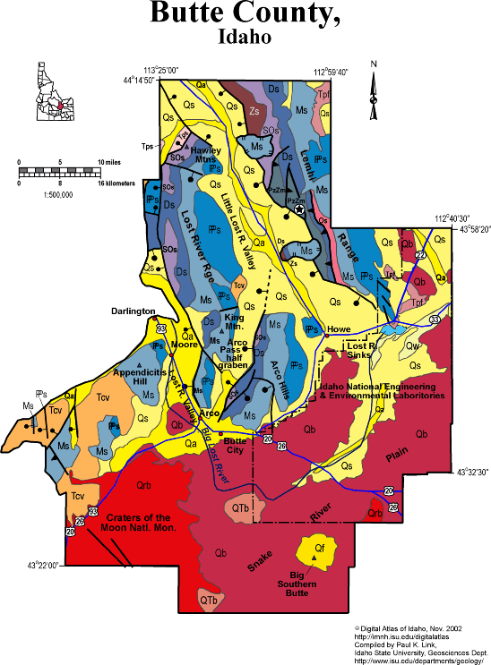
Butte CountyButte County, though sparsely populated, contains some very interesting geology. The Snake River Plain, with Craters of the Moon to the south and the INEEL to the northeast, underlies the southern portion of Butte County. Irrigated farming supports the economy near Arco and Howe, where alluvial sediment lies above Quaternary basalt lava. The lava supports only a sagebrush habitat, much of which is grazed off the INEEL boundary. The composite Quaternary rhyolite dome of Big Southern Butte makes a landmark visible for hundreds of miles. The Butte consists of thick pasty rhyolite magma that was emplaced upward, like a wart through a skin of Quaternary and Recent basalt. The Big Lost River flows northeast across basalt lava through the county, and ends in the Lost River Sinks east of Howe. Extensive irrigated agriculture is supported in this area. The northeastern part of Butte County is underlain by the Lemhi Range, composed of Mesoproterozoic Belt Supergroup overlain by Paleozoic strata, mainly carbonates. The rocks were folded and thrust faulted in the Cretaceous Sevier orogeny. The western boundary of the Lemhi Range is the active Lemhi Fault. To the west is the Little Lost River Valley, which provides access via Summit Creek to the high Lemhis. Just northeast of Howe near South Creek is a block of Paleozoic rocks that slid southwest from the Lemhi Range into the Little Lost River Valley. West of the Little Lost River is the Lost River Range, underlain by the same strata as the Lemhi Range, and deformed in similar manner. The active Lost River fault zone, which last moved in 1983, bounds the east side of the Lost River Valley east of Arco, Darlington and Moore. The Arco Hills, underlain by folded Paleozoic carbonate rocks, lie east of the Arco Pass half graben, an Eocene structure. Eocene Challis volcanic rocks covered north-trending half grabens in the Lost River Range, and are overlain by Oligocene and Miocene tuffs, conglomerates and lake beds. West of the Lost River Valley is Appendicitis Hill of the southern Pioneer Mountains. Much of the western corner of the county is underlain by Eocene Challis volcanic rocks, which overlie folded Mississippian turbidites of the Copper Basin Group. Craters of the Moon National Monument contains Quaternary and Recent basalt eruptive complex. The vents and fissures follow Basin and Range fault zones, which strike northwest across the area. The last eruption occurred only 2,000 years ago. See several sections in Rocks, Rails and Trails, including Snake River Plain and Borah Peak fault, plus the Link and Janecke geologic road log in Guidebook to the Geology of Eastern Idaho. P.K. Link, 10/02 |
 |
|
|||||||||||||||||||||||||||||||||||||||||||||||||||
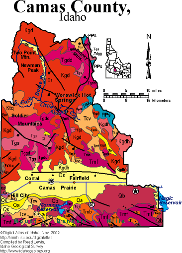
Camas CountyCamas County contains the Soldier Mountains, Camas Prairie and Mout Bennett Hills on the northern edge of the Snake River Plain, west of the Wood River. The Camas Prairie is a flat, alluvial covered agricultural area, downdropped from the Soldier Mountains by a concealed normal fault. The Mount Bennett Hills contain Miocene (12 to 8 Ma) rhyolites from the Twin Falls volcanic centers. The latest Miocene Magic Reservoir rhyolite dome and eruptive complex is found in the southeast corner of the county. The Soldier Mountains, and the Smoky Mountains to the northeast are underlain by Cretaceous granodiorite from the Idaho batholith, as well as complex Eocene intrusive complexes associated with the Challis magmatic episode. Diverse metallic mineral deposits occur here, associated with carbonaceous Paleozoic rocks of the central Idaho black-shale mineral belt, and Cretaceous and Eocene hydrothermal mineralizing systems. See sections on geology of this area in Rocks, Rails and Trails. P.K. Link, 10/02 |
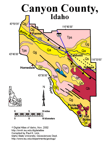
Canyon CountyCanyon County is entirely on the Snake River Plain, between the Snake River on the south and the foothills of the central Idaho Mountains on the north. Much of the county is underlain by Quaternary alluvium of the Boise River and Pleistocene gravel from glacial outwash. This gravel forms high benches above the Boise River. Several normal faults run northwest through the county, parallel with the northern boundary of the western Snake River Plain. Miocene lake beds make up the foothills on the northern boundary of the county. Quaternary basalt covers the southeastern section of the county. Miocene and Pliocene lake beds of the Glenns Ferry and Chalk Hills formation are found on the bluffs north of the Snake River. Also see the report by Othberg and Gillerman on the geology of the Boise Valley. P.K. Link, 10/02 |
|
|
|
|||||||||||||||||||||||||||||||||||||||||||||||||||||||||
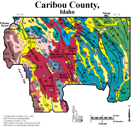
Caribou CountyCaribou County has the forested mountains of the Idaho-Wyoming thrust belt on its eastern side, and the wide Bear Lake and Gem valleys on its west, part of the Basin and Range province. Pleistocene volcanic rocks, mainly basalts, fill the Blackfoot Lava field and much of Gem Valley to the west. China Hat and China Cap are Pleistocene rhyolite domes. Phosphate mining still controls the economy of Caribou County, with active mines operated by Simplot, FMC, Monsanto, and Agrium between Soda Springs and Afton, Wyoming. P.K. Link, 10/02 |
 |
|
|||||||||||||||||||||||||||||||||||||||||||||||||||||||||||||||
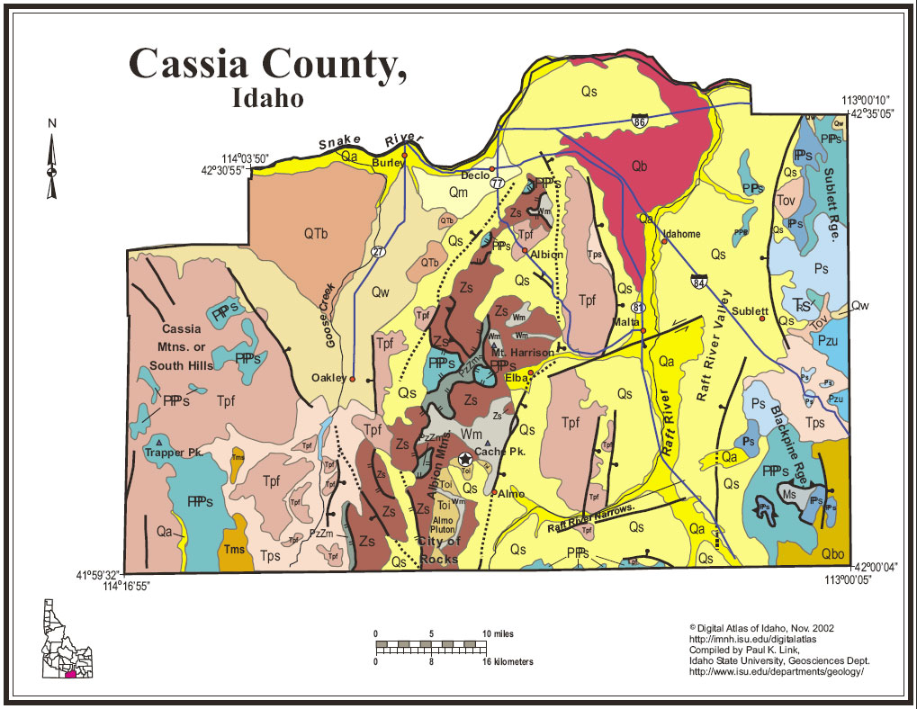
Cassia CountyCassia County, on the south side of the Snake River forms much of Idaho's southern boundary with Utah and Nevada on the west. It contains a diverse assemblage of rocks, including the oldest rocks in Idaho, the metamorphic Green Creek gneiss in the Albion Mountains core complex. Most of the people in Cassia County live in irrigated agricultural areas near Burley, Declo and Oakley. This area, on the southern edge of the Snake River Plain, is underlain by Quaternary basalt, including shield volcanoes visible today, overlain by windblown loess and alluvium. Thick cobble gravel derived from the Albion Range in Pleistocene time underlies the Oakley valley. The Albion Mountains, south of Albion, and west of Elba and Almo, are one of a series of turtleback-shaped uplifts of metamorphosed middle crust that are found along the axis of the Mesozoic Cordilleran orogenic belt, generally at the location of maximum crustal thickening during compressional tectonics. They contain Archean gneiss overlain by Proterozoic Elba quartzite and Paleozoic Clarks Basin and Harrison Summit schist and quartzite, below a low-angle detachment fault. Above the fault are less metamorphosed, folded Paleozoic rocks. The Raft River Mountains, just to the south across the Utah border are a similar feature. The Oligocene Almo Pluton, which underlies the City of Rocks, was intruded 25 million years ago into this domal uplift. The City of Rocks contains distinctive granite monoliths that were a landmark to the California Trail and are now a rock climber's playground. The Raft River detachment fault, an east dipping structure, exhumed the Albion core complex and downdropped the Raft River Valley and the volcanic rocks of the Jim Sage and Cottrell Mountains between Elba and Malta. The U.S. Department of Energy drilled a several-thousand-foot geothermal well south of Malta in the 1980s, but the project did not demonstrate economic potential for electrical generation. Southeast of the Raft River Valley are the Black Pine Mountains, underlain by folded and thrust-faulted Paleozoic rocks in the hanging wall of the Raft River detachment. These rocks formerly were on top of the City of Rocks area, and have been downfaulted to the east to their present location. They contain gold mineralization that was mined in the 1990s and at several previous times in the 20th century. The Sublett Range, east of the Raft River Valley, contains thick upper Paleozoic limestones. To the west of the Albion Range is Middle Mountain, which contains schistose quartzite that is mined for "Oakley Stone" a decorative flagstone shipped across the world. West of there, across Goose Creek, is the extensive Miocene Trapper Creek basin filled with tuffs and rhyolite ignimbrites from the Twin Falls volcanic center. The Cassia Mountains or South Hills, on the western edge of the county, contain spectacular cliffs in deep canyons, all cut from these rhyolite ignimbrites and fallout tuffs. See several sections of text in Rocks Rails and Trails. P.K. Link, 10/02 |
|
|
|||||||||||||||||||||||||||||||||||||||||||||||||||||||||||||||||||||
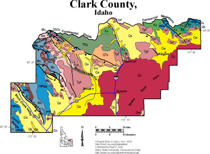
Clark CountyClark County, one of the least populated of Idaho's 44 counties, lies at the foot of the continental divide, and includes the cold, arid northeastern Snake River Plain. Quaternary basalt covers much of the area from Dubois north to Spencer, and supports sparse sagebrush grazing land. Alluvial areas are farmed with irrigation from the Snake River aquifer. Miocene and Pliocene felsic volcanic rocks, associated with the Heise and Yellowstone volcanic fields, occupy the area east of Spencer, and host Idaho opals. These formed when hot silica-rich water circulated through the young rhyolite lavas and tuffs. The Centennial Mountains, in the northeastern corner of the county, along the border with Montana, contain folded and thrust faulted Mesozoic and Paleozoic sediments, which lie above Paleoproterozoic basement rock. They belong to the Laramide province, where Mesoproterozoic and Neoproterozoic strata were never deposited beneath the basal Cambrian sandstone. West of Spencer are the Beaverhead Mountains, divided by the Medicine Lodge Creek from the Tendoy Range to the east along the Continental Divide with Montana. Limestones and tuffs of the Oligocene and Miocene Medicine Lodge Formation occupy the foothills on both sides of Medicine Lodge Creek. The Beaverhead Range extends north to Salmon and merges with the Bitterroot Range in southwest Montana, north of Lost Trail Pass. The range contains a thick package of folded and thrust faulted sedimentary rocks, including Mesoproterozoic Belt Supergroup (Apple Creek, Gunsight and Swauger formations), Neoproterozoic Wilbert Formation, and Paleozoic limestone and dolomite. The Tendoy Range is capped by the Cretaceous and Paleocene Beaverhead Conglomerate, which was shed from rising mountains to the north and west. Large rivers carried boulder conglomerate east to the Tendoy Range and much of southwest Montana. These quartzite clasts spread east to Jackson Hole, Wyoming and are now making their way back west again, carried by the Snake River. On the extreme southwest corner of the county is the dry Birch Creek valley and the southeast corner of the Lemhi Range. An active normal fault, the Beaverhead Range fault, bounds the east side of the Birch Creek Valley against the Beaverhead Range. Paleozoic carbonate rocks are exposed here. |
|
|
|||||||||||||||||||||||||||||||||||||||||||||||||||||||||||||||
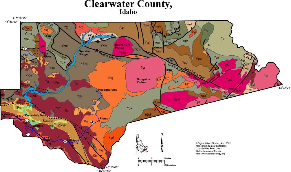
Clearwater CountyHuge Clearwater County contains vast tracts of steep country drained by the North Fork of the Clearwater River, now impounded behind Dworshak Dam, and largely inaccessible. Pierce and Weippe occupy a relatively flat uplifted area between the North Fork Clearwater and the Lochsa River to the south. Lewis and Clark followed ridges north of the Lochsa as they crossed the continent in 1805 and 1806. The northern part of the county is underlain by metamorphosed rocks of the Mesoproterozoic Belt Supergroup, folded and thrusted in the Cretaceous Sevier orogeny. No Paleozoic rocks are preserved. The Belt rocks are intruded by Cretaceous and Eocene plutons. The southern part of the county is underlain by the northern expanse of the Bitterroot lobe of the Idaho batholith near Pierce and Headquarters, and by a complex of Eocene intrusive rocks cut by the Kelly Forks Fault. Eocene granite of the Bungalow Pluton occupies the center of the County. On the southwest is the suture zone between North America and accreted terranes to the southwest, across the Clearwater river near Grangeville. The suture zone runs through the southwest part of Dworshak reservoir. Cretaceous to Permian Orofino Series rocks and Cretaceous orthogneiss underlie lava flows of the Columbia River basalts in much of the southwest part of the county. Miocene sediments were deposited in the upper portions of river valleys dammed by Columbia River basalts and crop out in numerous patches south of Elk River. Some of these Miocene sediments contain gold placers. P.K. Link, 9/02 |
|
|
|||||||||||||||||||||||||||||||||||||||||||||||||||||||||||||||||||||||||||||
Custer CountyCuster County lies in the heart of Idaho, and contains as diverse geology as many states and some countries. The county is mainly rugged mountains, with flat habitable terrane only in the Lost River, Pahsimeroi, and Sawtooth Valleys. The oldest rocks in the county are Paleoproterozoic gneiss in the core of the Pioneer Mountains core complex of the Pioneer Mountains above Copper Basin and Ketchum. Above this gneiss are Proterozoic and Paleozoic metasedimentary rocks, all intruded by an Eocene pluton. The core complex is uplifted on the Wildhorse detachment fault, which forms a domal pattern, and which moved from Eocene until Oligocene time. In the Pioneer and Boulder mountains north and south of the core complex is the thrust belt of Paleozoic rocks. Ordovician, Silurian and Devonian deep marine strata are found in the hanging wall of the Pioneer thrust fault, faulted below Pennsylvanian and Permian Sun Valley Group. East of the Pioneer thrust is the thick Mississippian Copper Basin Group, which contains the black conglomerates found in the Copper Basin and East Fork Lost River areas. The White Cloud Peaks, on strike to the northwest, contain similar strata to the Pioneers and Boulders. Here Cretaceous granodiorite, that underlies Castle Peak, highest in the White Clouds, intruded Devonian to Permian sedimentary rocks. Across the Salmon River at the Thompson Creek molybdenum mine, Cretaceous intrusions have produced mineralization still being mined in the 21st century. This entire area, plus the Smoky Mountains west of Ketchum contain dark-colored organic-rich sedimentary rocks of the central Idaho Black Shale Mineral Belt, Mineral exploration and production in these rocks controlled the early economic development of the area. The White Knob Mountains, west of Mackay, contain Mississippian limestone intruded by and Eocene granite. Extensive copper mineralization is found on the margins of the granite, and the Empire Mine and associated properties immediately west of Mackay are found in these rocks. East of the huge Lost River Valley and in the footwall of the west-dipping Lost River fault, are folded Paleozoic limestones and quartzites of the Lost River Range. Borah Peak, highest in Idaho looms above Chilly and the ISU Geoscience Lost River Field Station at its base along the Big Lost River. The northern half of the Lost River Range, north of Willow Creek Summit is the Pahsimeroi Mountains, which contain folded Mississippian strata on the south and unusual breccia at Grouse Peak on the north end immediately east of Challis. East of the Lost River Range, in the northeast corner of the county are Eocene and Oligocene conglomerate and tuff in the Donkey Hills and a western corner of the Lemhi Range underlain by Mesoproterozoic Belt Supergroup. The Pahsimeroi Valley extends north into the Salmon drainage, and lies on the hanging wall of the Lemhi fault. The northern third of the county, north of the Salmon River, is underlain mainly by Eocene volcanic rocks of the Challis Volcanic Group, cut by northeast-striking faults of the trans-Challis fault system, which controlled location of vents and hydrothermal systems that controlled mineralization, mainly of gold in the Yankee Fork area. On the western edge of the co0unty are the spectacular Sawtooth Mountains, looming west of Stanley Basin or Sawtooth Valley. These glaciated peaks are formed of both Cretaceous granodiorite of the Idaho batholith, and Eocene granite associated with the Challis Volcanic Group. See geology and regional discussions in Rocks, Rails and Trails, plus the Link and Janecke article in Guidebook to the Geology of Eastern Idaho P.K. Link, 10/02 |

 |
|
|||||||||||||||||||||||||||||||||||||||||||||||||||||||||||
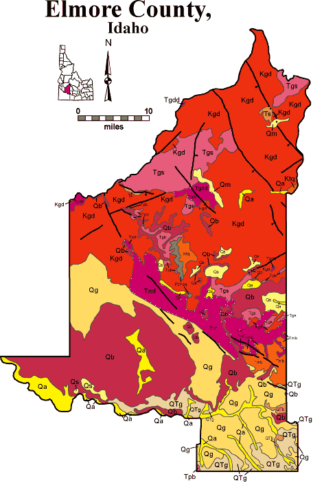
Elmore CountyElmore County covers a huge area from the Snake River on the south to the North Fork of the Boise River, deep in the Salmon River Mountains. It contains irrigated Snake River Plain farmland, vast areas of sagebrush desert, and much of the southern Salmon River Mountains, cut by three forks of the Boise River. Most of the population is near Glenns Ferry, on the historic crossing of the Snake Rive from the Oregon Trail. Mountain Home, on the bench above the Snake at the west end of the Mount Bennett Hills, is another population center. The southern third of Elmore County is on the Snake River Plain. Basalt flows and lake beds (Glenns Ferry and Chalk Hills Formations) make up bluffs above the Snake River. The Lake Bonneville Flood came through this canyon 14,500 years ago and deposited fields of boulders, dubbed "Melon Gravel". A normal fault bounds the northeast edge of the Snake River Plain, part of the eastern margin of the western Snake River Plain graben. This fault-bounded rift began to subside perhaps 12 million years ago on the shoulder of the Snake River Plain hotspot, then located west of Twin Falls. East of the normal fault are the Salmon River Mountains, underlain by Cretaceous Idaho batholith granodiorites, and Eocene granite and granodiorite of the Challis magmatic complex. The area is cut by northwest striking faults parallel with Basin and Range trends. The forks of the Boise River, however, flow southwest, across this grain, and all occupy deep canyons. Mining towns in these canyons, like Atlanta, Featherville and Rocky Bar, struggle to exist into the 21st century. Placer mining spoils are evident in several places. Atlanta contains diverse silver and gold mineralization, associated with the Cretaceous Idaho batholith. The west side of the Sawtooth Mountains, on the footwall of the Sawtooth normal fault to the east, form the northeastern edge of Elmore County. See geology discussions of the Idaho batholith in Rocks, Rails and Trails. P.K. Link, 10/02 |
 |
|
|
|
|||||||||||||||||||||||||||||||||||||||||||||||
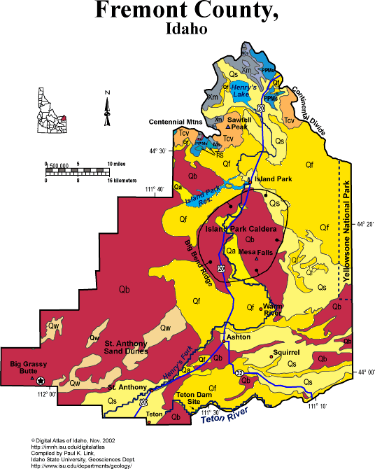
Fremont CountyFremont County occupies the northeast corner of the Snake River Plain and includes the western fringe of Yellowstone National Park. It is mainly underlain by volcanic rocks associated with the Snake River Plain and Yellowstone hot spot system. Quaternary sediments overlies these volcanic rocks and allow irrigated farming. The windblown St. Anthony sand dunes contain sand blown northeastward from now-dry lakes to the southwest on the Snake River Plain. The Island Park area forms the central part of Fremont County, and consists of the subsided Island Park Caldera, that erupted about 1.2 million years ago to form the Mesa Falls tuff, and then subsided since its underpinnings were withdrawn. As one drives north on the Ashton grade, one ascends the wall of the caldera. The Centennial Mountains, on the north edge of Fremont County, on the border with Montana, form the Continental divide. These mountains contain Paleoproterozoic gneiss basement, overlain by Cambrian through Triassic sedimentary rocks. These Paleozoic rocks are similar to those of the Teton Mountains, and much thinner than those of the Beaverhead Range to the west. On the southeast edge of Fremont County, south of Ashton, flows the Teton River, cut in a steep canyon through 2 million year old Huckleberry Ridge rhyolite welded tuff. It was here, in 1975, that the newly build Teton Dam broke, causing death and destruction downstream toward Newdale, Teton and Rexburg. P.K. Link, 9/02 |
 |
|
|||||||||||||||||||||||||||||||||||||||||||||||
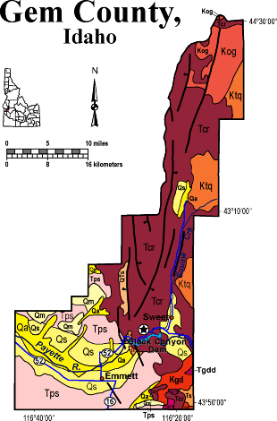
Gem CountyGem County covers a small area on the northern border of the Snake River Plain, including the drainage of Squaw Creek and the main channel of the Payette Rvier. On the southwest are outcrops of Miocene to Recent lake and fluvial beds in bluffs above the Payette River. Much of the northern panhandle of the county is underlain by Miocene (17 Ma) Columbia River basalt. North-trending fault zones parallel Squaw Creek and control the linear topography of the northern county. On the eastern edge of the county are several outcrops of Cretaceous tonalite, orthogneiss and granodiorite of the Idaho batholith complex. Cenozoic Geologic History of Gem and Payette Counties The Cenozoic geologic history of Gem and Payette Counties is similar to many areas in southwestern Idaho. Volcanism resulted mainly from the faulting and initiation of the Western Snake River Plain in the Miocene. Miocene sedimentation occurred within the many lakes interconnected at times by a river system that was present in the newly formed rift environment. Columbia River volcanic flows and pyroclastic rocks that were erupted from both central and fissure-type vents represent the oldest volcanic rocks in the area. These lava flows temporarily blocked major surface water drainages causing extensive deposits of alluvial, fluvial and lacustrine sediments referred to as the Miocene - Pliocene Payette and Sucker Creek and Pliocene - Pleistocene Idaho Formations. The age of these sedimentary deposits ranges from Miocene to the Pleistocen. These units exhibit many sedimentary structures. The fluvial facies exhibits cross bedding, ripples, scouring, and delta foresets. Well-preserved fluvial and lacustrine facies of the Idaho Formation can be observed along Old Freeze Out Hill Road. Columbia River basalts are widely distributed over Gem County and parts of eastern Payette County. Squaw Mountain represents a major block of the Columbia River Basalt which is estimated to have been uplifted approximately 2500' along its eastern margin (Savage, 1961). Other exposures of Columbia River basalts can be observed along the north side of Black Canyon Reservoir. Silicic volcanic rocks, rhyolitic welded ash flow tuffs, also crop out in the region and are stratigraphically above the Columbia River basalt units. Exposures of the rhyolitic ash flow tuff units can be observed in the Pearl region. T. Schiappa and P.K. Link, 10/02 |
 |
|
|||||||||||||||||||||||||||||||||||||||||
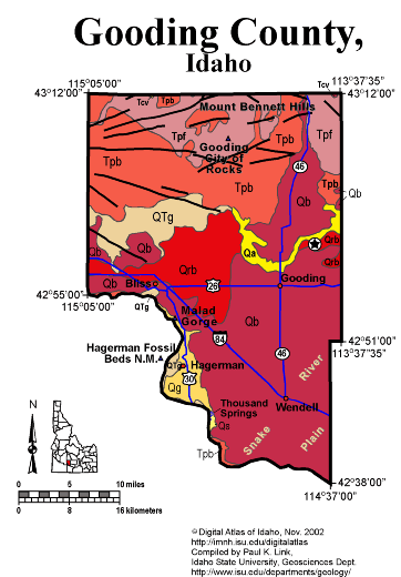
Gooding CountyGooding County is entirely on the Snake River Plain, north of the Snake River. Thus all the rocks are Miocene and younger, with Quaternary basalt covering most of the county. In the north the Gooding City of Rocks, carved from Miocene rhyolite ignimbrites of the Twin Falls Volcanic Field, forms the south flank of the Mount Bennett Hills. A series of east-west normal faults cuts the Mount Bennett Hills, reflecting the rift-valley structure of the western Snake River Plain. On the south, in the Snake River Canyon, are exposures of Miocene and Pliocene Glenns Ferry Formation below the Quaternary basalt flows. Hagerman Fossil Beds National Monument, itself located on the west side of the Snake River in Twin Falls County, has its headquarters in Hagerman. Malad Gorge, a narrow canyon cut by the Wood River in the last few hundred thousand years, is a unique feature of southern Gooding County. P.K. Link, 9/02 |
|
|
|||||||||||||||||||||||||||||||||||||||||||||||||||||||||||||||||||||||||||||||||
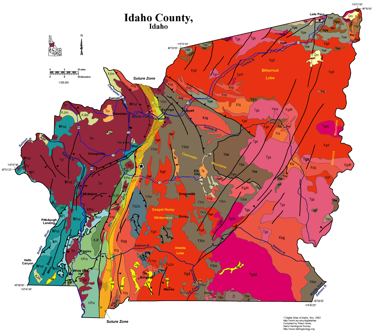
Idaho CountyIdaho County spans the River of No Return and Selway-Bitterroot Wilderness and includes both the eastern and western borders of the state. Its geology is complex and diverse. On the west are the Seven Devils Mountains and Hells Canyon of the Snake River. The rocks here are Paleozoic metavolcanic and metasedimentary rocks from accreted terranes that formed in the Pacific and docks in the Early Cretaceous, along the Idaho Suture Zone, which runs north-south through Idaho County, following the Clearwater River. West of this suture are diverse exotic volcanic assemblages, overlain by Miocene Columbia River basalts that form the Camas Prairie near Grangeville. East of the suture are the Clearwater Mountains, underlain by Proterozoic and Paleozoic rocks with affinity to North America, and intruded by the Cretaceous Idaho batholith. Many of these strata are Mesoproterozoic Belt Supergroup, though some have uncertain affinity. On the southeast and along the eastern border with Montana in the Bitterroot Mountains are Eocene intrusive rocks, associated with the Challis magmatic episode. Northwest striking faults parallel with the trans-Challis fault zone cut this country, southeast of Elk City. Southeast of Grangeville, in the Gospel-Hump Wilderness are Neoproterozoic Windermere Supergroup volcanic rocks with an age of 687 Ma, that overlie glacial diamictite correlated with the Pocatello Formation of southeast Idaho. Excellent discussion of the geology of this area is found in Orr, W.N., and Orr, E.L., 2002, Geology of the Pacific Northwest, 2nd ed., McGraw Hill Pubs., p. 138-159. Good information is also contained in Alt, D. D., and Hyndman, D.W., 1989, Roadside Geology of Idaho, Mountain Press, Missoula, 393 p. P.K. Link, 10/02 |
 |
|
|||||||||||||||||||||||||||||||||||||||
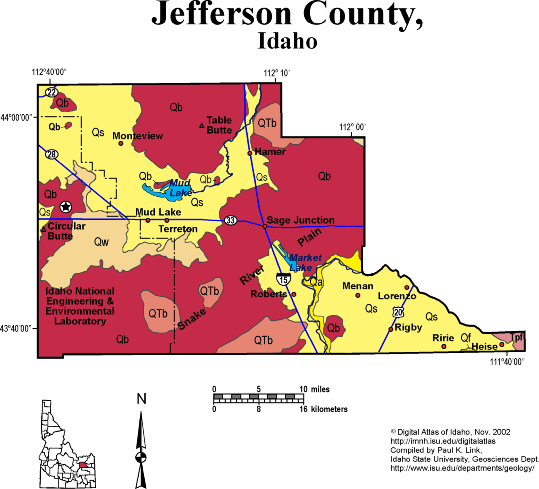
Jefferson CountyJefferson County is entirely on the Snake River Plain, mainly north and west of the Snake River where it takes its horseshoe bend from flowing northwest to flowing south. The bend, likely controlled by the topographic high of the Menan Buttes in adjacent Madison County, allows Jefferson County to have large areas of rich irrigated agriculture in the south and east near Rigby and Market Lake. The northern and western parts of Jefferson County are Quaternary basalt lava, with the sedimentary basin of Mud Lake in the northwest corner. Around Mud Lake is another area of irrigated farming, with soils formed from lake beds of Lake Terreton, which occupied this area in much of Quaternary time. The northeast corner of the INEEL occupies the western edge of Jefferson County. See discussion of geology of the Yellowstone-Snake River Plain volcanic system in Rocks, Rails and Trails, Topographic Development of Idaho maps, and Hughes et al. and Embree et al. papers in Geology of Eastern Idaho. P.K. Link, 10/02 |
 |
|
|||||||||||||||||||||||||||||||||
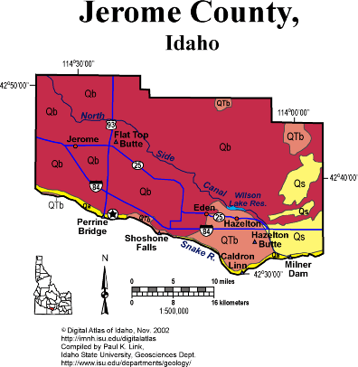
Jerome CountyJerome County is on the north side of the Snake River, totally within the Snake River Plain. Thus all the rocks are Miocene or younger, and mainly basalt lava flows. A few areas of Quaternary sediment make good irrigated farming. Near Eden and Hazelton are dry cascades and waterfalls formed during the Lake Bonneville Flood about 15,000 years ago. There was too much water for the Snake River Canyon, and the excess overflowed in a now-dry flood channel that isolated an island south of Hazelton. The area east of Eden has some spectacular potholes. P.K. Link, 9/02 |
 |
|
|||||||||||||||||||||||||||||||||||||||||||||||||||||||||
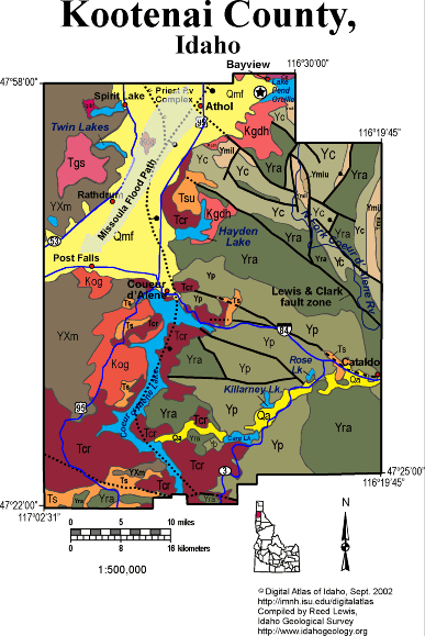
Kootenai CountyThe bulk of Kootenai County south and east of Coeur d'Alene is underlain by Mesoproterozoic Belt Supergroup rocks continuing west from their extensively mineralized area along the Lewis and Clark fault zone, in the Silver Valley in Shoshone County. The western part of the county, west of Coeur d'Alene Lake and the Rathdrum Prairie belongs to the lower plate of the Priest River core complex. The normal fault bounding the uplifted metamorphic rocks of the core complex dips eastward and follows the north-trending basin of Lake Coeur d'Alene. The south fork of the Coeur d'Alene River contains mining wastes from the Silver Valley. The area near Rose and Killarney Lakes as well as at Cataldo, contains a layer of zinc and lead-rich gravel or tailings, in the shallow subsurface. When the lake level changes these mine wastes are disturbed and metals may be released into solution. This is an ongoing scientific, political, and economic challenge. The Lake Missoula Floods charged southwestward down the Rathdrum Prairie toward Post Falls, and into the Spokane River in eastern Washington. Miocene Columbia River basalts cover the rolling Palouse country of the southwestern part of the County, north of the Coeur d'Alene Tribal Casino. Cretaceous intrusive rocks are found in the core of the Priest River uplift south of Coeur d'Alene, and northeast of Hayden Lake. Eocene granitic rocks intrude the core complex west of Spirit Lake. Written by P.K. Link, 9/02 |
 |
|
|||||||||||||||||||||||||||||||||||||||||||||||||||
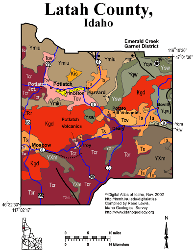
Latah CountyThe rolling Palouse of western Latah County is underlain by loess hills deposited above Miocene Columbia River basalt that flowed eastward from vents in Washington. Miocene and younger sediments were deposited upstream of the ends of these basalt flows and underlie much of the farming country between Moscow and Bovill. The unique Oligocene Potlach volcanics are found in the northwestern part of the quadrangle. The Potato Hill volcanics are found west of Bovill. The eastern part of the county is underlain by Mesoproterozoic Belt Supergroup, with the metamorphosed garnet-bearing Wallace Formation exposed in the northeastern part of the county, south of Fernwood and the Emerald Creek garnet district. The central part of the county is underlain by Cretaceous granodiorite, one of the northern parts of the Idaho batholith, that extends westward into eastern Washington. Written by P.K. Link, 9/02 |
|
|
|||||||||||||||||||||||||||||||||||||||||||||||||||||||||||||||||||||||||||
Lemhi CountyLemhi County forms much of eastern Idaho's border with Montana along the Beaverhead Mountains and contains complex geology, rich mineral deposits and tracts of wilderness near the Salmon River. The southern part of the county is within the Basin and Range province with the Beaverhead and Lemhi Ranges and intervening northwest-trending valleys. The Salmon River flowing north from Challis toward Salmon and North Fork, forms the western boundary of the Basin and Range province. The Salmon turns west at North Fork and flows into the River of No Return Wilderness west of Shoup. It joins large tributaries from the south, including Panther Creek and the Middle Fork of the Salmon River, before flowing west into Valley and Idaho Counties. Much of Lemhi County is underlain by Mesoproterozoic strata of the Belt Supergroup, deposited between 1470 and 1370 years ago. These rocks include the Yellowjacket Formation, Lemhi Group, Swauger and Gunsight formations, and make up most of the northern Lemhi and Beaverhead Ranges and the Salmon River Mountains. Paleozoic sedimentary rocks are exposed in the central Beaverhead and southern Lemhi Ranges, and are mainly limestones. In the Panther Creek area and to the northwest, Belt Supergroup rocks were buried, metamorphosed and intruded by granitic rocks around 1370 Ma. The area was also subject to intrusion of granitic rocks in Ordovician time, an anomalous age regionally in the Cordilleran orogenic belt. The Proterozoic and Paleozoic rocks were folded and thrust faulted in Mesozoic time, as part of the Cordilleran thrust belt. A major thrust fault, the Brushy Gulch thrust is exposed northwest of Salmon, and may continue into the Cabin thrust fault system of the Beaverhead Range in Montana. Eocene volcanic rocks of the Challis volcanic group are found in the southwest corner of Lemhi County, and are cut by northeast striking faults of the Trans-Challis fault system. They are also intruded by coeval Eocene granitic rocks in the Bighorn Crags and Camas Creek areas. Complex Eocene to Miocene normal faulting produced north-trending basins near Salmon and in the Summit Creek area of the Lemhi Range. Miocene to Recent Basin and Range faulting uplifted the existing mountains. For more information see the Link and Janecke and Price et al. articles in the Guidebook to the Geology of Eastern Idaho and sections in Rocks, Rails and Trails. P.K. Link, 10/02 |

 |
|
|||||||||||||||||||||||||||||||
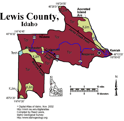
Lewis CountyLewis County, on the south side of the Clearwater River, contains the steep sided Camas Prairie plateau underlain by Miocene lava flows of the Columbia River basalts. Poking through at several places are Cretaceous and Jurassic island arc rocks of the Accreted terranes. The Suture zone runs just east of the county line along the Clearwater River through Kamiah. These plateaus are unusual, since the flat ground is on top, and the cities are generally in narrow valley bottoms. The Clearwater River cuts through the plateau, following the track of the Cretaceous suture zone. Written by P.K. Link, 9/02 |
 |
|
|||||||||||||||||||||||||||||||||||||
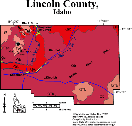
Lincoln CountyLincoln County, close to the geographic center of the Snake River Plain, is entirely underlain by volcanic rock less then 10 million years old. The bulk of the county is Quaternary basalt lava, erupted from several shield volcanoes and fissure systems that are still visible. Farming near Richfield and Shoshone is possible in areas where alluvial or windblown soil has accumulated, and requires irrigation from the Big and Little Wood Rivers. The main line of the Union Pacific Railroad crosses the basalt lava east-west through Shoshone, which started as a railroad town. The Ketchum and Camas Prairie branches of the Union Pacific run northeast through Richfield, following the Little Wood River. Black Butte basalt volcano in the northwest part of the county, erupted in the last 10,000 years, producing a river of lava that flowed down the Big Wood River canyon. Shoshone ice caves are found in a lava tube, or underground pipe, where the molten lava flowed. Late Miocene rhyolites of the Magic Reservoir volcanic field (5 Ma) are found west of Black Butte. See discussion of Snake River Plain-Yellowstone volcanism in Rocks, Rails and Trails, plus the Topographic Development of Idaho maps. P.K. Link, 10/02 |
 |
|
|||||||||||||||||||||||||||||||||||||||||||||||
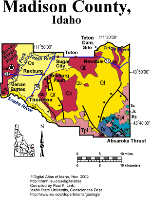
Madison CountyMadison County contains the northwest end of the Idaho-Wyoming thrust belt in the Big Hole Mountains. On the south is the Snake River half-graben, bounded by the active Rexburg fault. On the north and west are the wide, irrigated Teton bench and Upper Valley of the Snake River Plain. The Absaroka thrust places Devonian over Mesozoic strata in the Big Hole Mountains, which extend southwestward into the complex mountains of the Idaho-Wyoming thrust belt. The Big Hole range is bounded on the west by a normal fault, the northwest extension of the Grand Valley fault, which controls the location of the Snake River and its half-graben valley west of Heise. North of Heise, in the cliffs below Kelly Canyon ski area are spectacular exposures of rhyolite volcanic rocks of the Heise caldera, erupted between 4 and 6 million years ago. Quaternary basaltic volcanism has produced the landscape of the western part of Madison county, with still active basaltic lava fields present. Menan Buttes are a phreatomagmatic eruptive tuff cones that formed where basalt magma interacted with Snake River groundwater, producing explosive steam eruptions and the low, wide eruptive cones composed of both basalt tephra and Snake River gravel cobbles and pebbles. The northeastern part of the county lies on benches above the Teton River. The benches slope upward toward the Yellowstone plateau, and are underlain by Quaternary rhyolite covered by windblown loess. The Teton Dam, which broke with a catastrophic flood in 1976, was located in the Teton River canyon, anchored in Pleistocene rhyolite ignimbrite of the 2 Ma Huckleberry Ridge tuff. See text on Snake River Plain-Yellowstone Hot Spot in Rocks, Rails and Trails, Topographic Development of Idaho maps, and Embree et al. field trip in Guidebook to the Geology of Eastern Idaho. P.K. Link, 10/02 |
 |
|
|||||||||||||||||||||||||||||||||||||
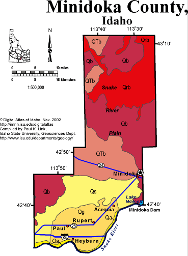
Minidoka CountyMinidoka County is entirely on the Snake River Plain, on the north side of the Snake River west of Minidoka Dam and Lake Walcott. Extensive irrigated farming of the North Side Tract occurs on alluvial soils between Minidoka, Rupert and Heyburn. To the north, across the Union Pacific mainline are Quaternary basalt lava flows, heading toward Craters of the Moon to the northeast. This country is empty sagebrush desert. See discussion of Snake River Plain geology from Rocks, Rails and Trails. P.K. Link, 10/02 |
|
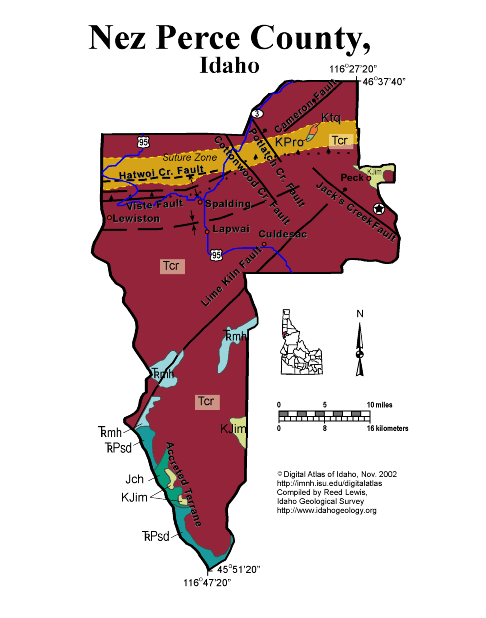
Nez Perce CountyAlmost all of Nez Perce County is underlain by the Miocene basalts of the Columbia River basalts which make up the steep sided plateau south of Lewiston. South of the suture zone, which runs east-west along the Clearwater River through Lewiston, these basalts lapped against Cretaceous and Jurassic island arc and sedimentary rocks of the Seven Devils complex and other accreted terranes. The Miocene basalts filled in and flowed up an ancestral Clearwater River canyon about 17 million years ago. Written by P.K. Link, 9/02 |
|
 |
|
|||||||||||||||||||||||||||||||||||||||||||||||||||||||||
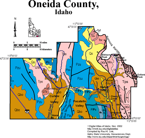
Oneida CountyOneida County spans the Utah border west of Interstate highway 15, south of Pocatello. Malad City is the county seat and only town of any size. The county is within the Basin and Range province with north-trending normal faults bounding the east sides of the ranges. The active Wasatch fault extends north of Malad Valley and then bends west to west of Elkhorn Peak. The Bannock Range contains Neoproterozoic through Ordovician strata which are cut by slow-angle normal faults associated with the Bannock Detachment fault, which formed around 10 Ma. The ranges west of Malad Valley contain mainly upper Paleozoic rocks. The Manning Canyon thrust fault is exposed in a small canyon west of Malad, in the Blue Spring Hills. Lake Bonneville reached into Malad, Curlew, Pocatello, and Juniper Valleys, along the Idaho-Utah border. See geology and regional text in Rocks, Rails and Trails. P.K. Link, 10/02 |
|
|
|||||||||||||||||||||||||||||||||||||||||||||||||||||||||||||
Owyhee CountyOwyhee County covers a huge area in southwest Idaho, south of the Snake River. It contains the wilderness of the Owyhee Plateau and the narrow canyons of the Bruneau and Jarbidge rivers. In the northwest it contains Cretaceous granodiorite near Silver City, an outlier of the Idaho batholith, that intrudes Paleozoic sedimentary rocks. Silver City was site of a mining boom in the middle 19th century. The bulk of the county is underlain by voluminous rhyolite lava flows and ignimbrites erupted from the Bruneau-Jarbidge eruptive center around 16 million years ago. These high temperature, high volume rhyolite eruptions are unique in the world. They were produced by the Snake River Plain hotspot, as it sat under southwest Idaho in middle Miocene time. Pliocene basalt covers the rhyolite in much of the eastern and southern parts of the plateau. The margins of the Owyhee Plateau expose Miocene lake and fluvial sediments, and basalt flows, deposited in Lake Idaho and its margins. Along the Snake River are Quaternary fluvial sediments and basalt lava flows. The entire county is laced with northwest striking faults, mainly normal faults, dipping north, toward the western Snake River Plain graben. P.K. Link, 10/02 |

 |
|
|||||||||||||||||||||||||||||||||||||
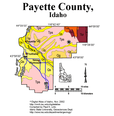
Payette CountyPayette County contains the mouth of the Payette River where it empties into the Snake River, and forms the western border of Idaho. The bulk of the county is irrigated agricultural land, with agriculture occurring on Miocene lake beds and Quaternary stream deposits. A small area of Columbia River basalt is found in the northeast corner of the county, where it is cut by north-striking normal faults. Cenozoic Geologic History of Gem and Payette Counties The Cenozoic geologic history of Gem and Payette Counties is similar to many areas in southwestern Idaho. Volcanism resulted mainly from the faulting and initiation of the Western Snake River Plain in the Miocene. Miocene sedimentation occurred within the many lakes interconnected at times by a river system that was present in the newly formed rift environment. Columbia River volcanic flows and pyroclastic rocks that were erupted from both central and fissure-type vents represent the oldest volcanic rocks in the area. These lava flows temporarily blocked major surface water drainages causing extensive deposits of alluvial, fluvial and lacustrine sediments referred to as the Miocene - Pliocene Payette and Sucker Creek and Pliocene - Pleistocene Idaho Formations. The age of these sedimentary deposits ranges from Miocene to the Pleistocene. These units exhibit many sedimentary structures. The fluvial facies exhibits cross bedding, ripples, scouring, and delta foresets. Well-preserved fluvial and lacustrine facies of the Idaho Formation can be observed along Old Freeze Out Hill Road. Columbia River basalts are widely distributed over Gem County and parts of eastern Payette County. Squaw Mountain represents a major block of the Columbia River Basalt which is estimated to have been uplifted approximately 2500' along its eastern margin (Savage, 1961). Other exposures of Columbia River basalts can be observed along the north side of Black Canyon Reservoir. Silicic volcanic rocks, rhyolitic welded ash flow tuffs, also crop out in the region and are stratigraphically above the Columbia River basalt units. Exposures of the rhyolitic ash flow tuff units can be observed in the Pearl region. T. Schiappa and P.K. Link, 10/02 |
 |
|
|||||||||||||||||||||||||||||||||||||||||||||||||||||||||||||||
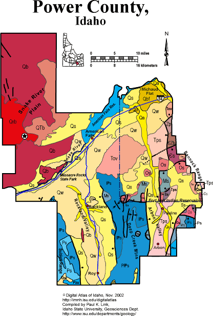
Power CountyPower County straddles the Snake River west of Pocatello. It has fresh basalt lava of the Great Rift and Kings Bowl in its northwestern corner. The central part of the county is agricultural land irrigated by the Snake River. Here 70,000 years ago the ancestral American Falls lake existed. South of the Snake River, farming occurs in Rockland and Arbon Valleys, south of the Snake River. Massacre Rocks along the Snake River is a Miocene basalt eruptive center. The Oregon Trail runs through it. See description in Rocks, Rails and Trails. The Bannock, Deep Creek and Sublett Ranges, south of the Snake River, contain Paleozoic sedimentary rocks in the hanging wall of the Putnam thrust fault. See geology description in Rocks, Rails and Trails. P.K. Link, 10/02 |
|
|
|||||||||||||||||||||||||||||||||||||||||||||||||||||||||||||||||
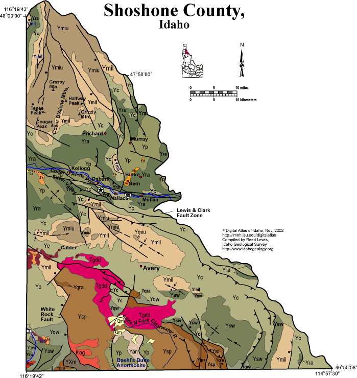
Shoshone CountyShoshone County covers a huge area north of the Clearwater River, and including the Silver Valley, which was a main source of wealth in north Idaho for much of the 20th century. Much of Shoshone County is rugged, tree-covered mountains, with people only living and traveling along the east-west corridor along the South Fork Coeur d'Alene River through Kellogg and Wallace. The Silver Valley follows the Lewis and Clark shear zone, an intracontinental fault zone with multiple stages of movement that extends eastward through much of southwest Montana. The silver and lead mineral deposits of the Silver Valley are hosted by the Revett Quartzite of the Belt Supergroup, and occupy huge veins in shear zones. Today the environmental cleanup of mine wastes in the area pumps millions of dollars into the economy deflated by closure of most of the mines. Most of the rocks in Shoshone County are Mesoproterozoic Belt Supergroup, deformed into northeast-vergent folds and thrust faults in the Cretaceous Sevier orogeny. There are only two Cretaceous granitic intrusions in the southwest part of the county. Eocene granodiorite is found extensively south of Avery, in the upper plate of the Boehl's Butte metamorphic complex. The metamorphic complex, in the drainage of the Little North Fork of the Clearwater River, exposes unique Mesoproterozoic rocks including anorthosite, a rare intrusive rock. P.K. Link, 9/02 |
 |
|
|||||||||||||||||||||||||||||||||||||||||||||||||
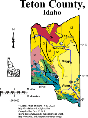
Teton CountyMuch of Teton County occupies Pierre's Hole, or the Teton Valley, which lies west of the Teton Mountains and northeast of the Big Hole Mountains. The bulk of the county is underlain by Quaternary sediment, and is thus eminently suited for agriculture, which has dominated the economy until the last 20 years when vacation homes and tourism have become increasingly important. The Big Hole Mountains, in the southwestern part of the county, contain folded and thrust faulted sedimentary rocks, which in Teton County are mostly of Mesozoic age. Coal is found in Cretaceous strata in the Horseshoe basin west of Driggs. In the 1980s wells were drilled for oil in these mountains. Teton Pass, at the southeast corner of the county, exposes very complex geology where the north dipping Cache Creek reverse fault, that formed in the Paleocene Laramide orogeny, impinged on rocks carried northeastward by the south-dipping Jackson thrust fault of the Idaho-Wyoming thrust belt Miocene rhyolite of the Heise and Yellowstone volcanic fields occupies the north end of the Big Hole Mountains, and is incised deeply by the Teton River as it tracks westward toward the Snake. The eastern border of the county, and the state of Idaho, is in the agricultural area west of the Teton Mountains. The Tetons rise dramatically on dip slopes formed from west-dipping Paleozoic carbonate strata. At the top of the Targhee ski area, the rocks are Mississippian. On Table Mountain they are the Cambrian-Archean unconformity, and on the Grand Teton the rocks are Archean gneiss. P.K. Link, 9/02 |
|
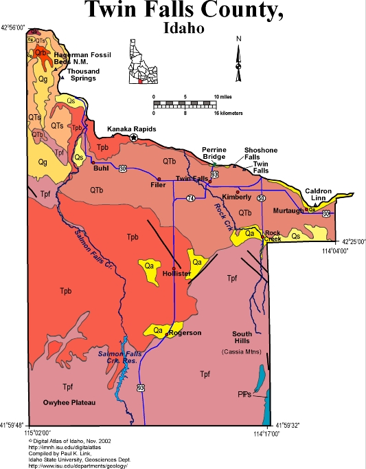
Twin Falls CountyTwin Falls County covers a large area on the south side of the Snake River. It includes the South Hills or Cassia Mountains, made of a spectacular pile of north dipping rhyolite ash flows laid out for view in Rock Creek Canyon. Under these rhyolites are Pennsylvanian and Permian sedimentary rocks that are equivalent to the Sun Valley Group near Hailey and Ketchum. On the southwest are the foothills of the Owyhee Plateau, also underlain by Miocene ignimbrites and rhyolite lava flows. In the central part of Twin Falls county are extensive irrigated fields, that use Snake River water withdrawn at Milner Dam east of Murtaugh. The Snake River, with its spectacular canyon deepened during the Lake Bonneville Flood about 15,000 years ago, forms the northern boundary of the county. Shoshone Falls cascades over Miocene rhyolite of the same age as the ash flows in the South Hills and in the Gooding City of Rocks. Twin Falls is cut in Quaternary basalt. Huge gravel bars of "melon gravel" line the Snake River Canyon west of Twin Falls near Buhl and Hagerman. In the northwestern corner of the county are the Pliocene fossils beds of Hagerman Fossil Beds National Monument. These river and lake beds contain diverse mammal, fish, reptile and other fossils that are about 3 to 4 million years old. P.K. Link, 9/02 |
|
|
|
|||||||||||||||||||||||||||||||||||||||||||||||||||||||||||||||
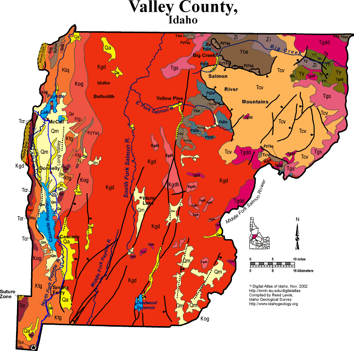
Valley CountyValley County covers a huge area in central Idaho, from Long Valley and McCall east to the Middle Fork of the Salmon River. The South Fork of the Salmon divides the county in two, flowing north toward the Main Salmon river, which is north across the border in Idaho county. The Payette River drains southward in the western part of the county. On the extreme northwest are accreted terrane rocks west of the Idaho suture zone. East of the suture are Cretaceous tonalites and orthogneiss of the Idaho batholith, which pass eastward to granodiorite that underlies the bulk of the county. A few inliers of Proterozoic and Paleozoic sedimentary rocks remain, as roof pendants to the batholith. On the northeast is a downdropped block, the Thunder Mountain caldera, filled with Eocene Challis volcanic group rocks. North of this block of volcanic rocks is a northwest trending belt along Big Creek that exposes Mesoproterozoic Belt Supergroup strata and unique Neoproterozoic intrusive rocks. Miocene and younger north-striking faults, part of the Basin and Range system, cut the batholith of the central part of the county, and form the Long Valley graben near Cascade Reservoir and Payette Lake. Geology near McCall Three major rock groups are exposed near McCall, Idaho. These include: the Cretaceous Idaho batholith, the Triassic-Jurassic metamorphosed island-arc sedimentary and volcanic rocks of the Seven Devils Group and the Miocene flood-basalt flows of the Columbia River Basalt Group. Several structural features are prevalent in the area and most likely control along with the past glaciation the geomorphology in the region. Structurally, McCall is situated at the end of Long Valley, a major tectonic and structural feature of west central Idaho. The West Mountain escarpment is the high ridge formed along the west side of the Long Valley fault. West Mountain and Long Valley are part of a group of linear north-south ranges and valleys formed by block faulting during the late Tertiary and Quaternary. As West Mountain rose and Long Valley subsided, as much as 7,000 feet of alluvium accumulated in the valley. Glacial deposits are divided into two categories on the basis of origin. "Till" is unsorted, rounded glacial sediments which commonly form moraines. Moraines can be one of four types. "Lateral" moraines are formed from the large accumulations of unsorted debris at the glacier-valley wall interface. "Medial" moraines form when two glaciers merge, and their lateral moraines are incorporated into the center - or medial portion - of the glacier, much like when two streams come together. A "Terminal" moraine is one that marks the furthest advance of the glacier; each farther-reaching advance wipes out the previous terminal moraine. "Recessional" moraines mark periods when the glacier is retreating - that is, the end of the glacier (the snout) where moraine is being deposited is short of the terminal glacier. It is important to remember, however, that even when a glacier is retreating the ice and sediment movement is always forward. In terms of glacial sediment transport, a glacier is not unlike a conveyor belt that can lengthen and shorten as conditions mandate. The second category of glacial deposit is not formed by flowing ice, but flowing water and is referred to as outwash. "Outwash" is deposited by meltwater discharging at the base of glaciers. Outwash from glaciers commonly forms expansive braided stream networks downvalley from glaciers and differ from moraines in that outwash sediments are well-sorted. Glacial features can be found around the area as most of the broad, high elevation region north of McCall was buried by an ice cap during the Pleistocene. Payette Lake and Little Payette Lake were formed as a result of glaciation in the region as valley glaciers carved the basin and deposited the moraines which impound the lakes. Other glacial geomorphic features, such as cirques - the alpine headwalls where glaciers begin - and medial moraines, around the area are visible in the landscape. An example would be Timber Ridge which formed originally as a large prominent medial moraine. Meltwater streams from these glaciers coursed across the valley depositing thick deposits of sand and gravel that can be seen as high terraces above the Payette River. These terraces are relict valley floors that have been incised as the post-glacial climate has changed and discharges in the Payette drainages have diminished. See Winston et al. article in Guidebook to the Geology of Eastern Idaho. Tamra Schiappa and P.K. Link, 10/02 |
 |
|
|||||||||||||||||||||||||||||||||||||||||||||||
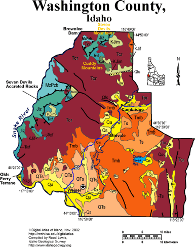
Washington CountyWashington County covers a large area on the south slopes of the Seven Devils Mountains and across the Weiser River Valley. It is entirely underlain by accreted terrane rocks, but these are only exposed along the western border, in the canyon of the Snake River. Much of the central and eastern parts of the county are underlain by Miocene Columbia River basalt flows, cut by normal faults into gently tilted blocks. The Weiser River Valley contains Miocene sandstones deposited in rivers draining the Idaho batholith in the last 10 million years. These contain mercury deposits east of Weiser. The geology of the region between Riggins and Boise to the south reflects a long history of plate boundary interactions and terrestrial responses. Exposed along this route is the eastern edge of the Miocene Columbia River Basalt and associated sedimentary units, the western edge of the extensive plutonic rocks that comprise the late Cretaceous Idaho Batholith, and metamorphosed sedimentary and volcanic rocks of the Jurassic Seven Devils group. During the Jurassic, an oceanic trench formed off the western margin of North American near the present western Idaho border. North America was moving west, away from the mid-Atlantic oceanic ridge. As the North American continental plate moved westward, the Pacific oceanic plate slid beneath it, and thus beneath the location of the future Idaho. Riding on top of the Pacific oceanic floor were numerous island arcs that eventually were emplaced onto the western margin of North America - prime examples of these emplaced volcanoes are the Seven Devils along Hells Canyon. These rocks are visible in Hells Canyon, along US Hwy 95 outside of Riggins, and along State Hwy 55 and US Hwy 95 near New Meadows. Other geologic features that are visible along US Hwy 95 are Miocene Columbia River Basalts, deposited from fissure eruptions, and Miocene-Pliocene sedimentary units deposited as the result of stream blockage which occurred as streams were dammed up by basaltic flows. Additional information on the Idaho Batholith can be found in the description of the geology of Boise County. An important reference to the geology of the Hells Canyon is U.S. Geological Survey Professional Paper 1438, Geology of the Blue Mountains region of Oregon, Idaho, and Washington; petrology and tectonic evolution of pre-Tertiary rocks, edited by T.L. Vallier and H.C. Brooks. Excellent discussion of the geology of this area is found in Orr, W.N., and Orr, E.L., 2002, Geology of the Pacific Northwest, 2nd ed., McGraw Hill Pubs., p. 138-159. Good information is also contained in Alt, D. D., and Hyndman, D.W., 1989, Roadside Geology of Idaho, Mountain Press, Missoula, 393 p. Tamra Schiappa and P.K. Link, 10/02 |
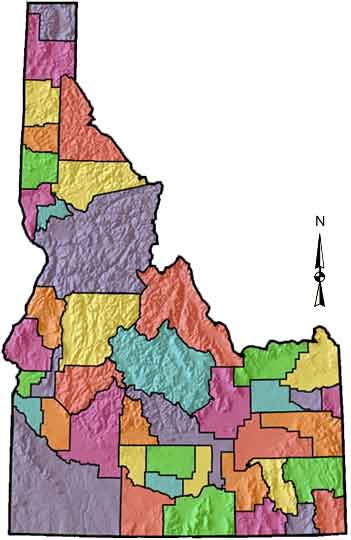 |
COUNTIES:
|
|||||||||||||||||||||||||||||||||||||||||||||
|
There are 44 counties in Idaho. The term county comes from an ancient unit of government. Originally the term referred to the area controlled by a court in medieval England. Counties have developed in the United States from colonial times. Every state in the United States has counties except for Louisiana which has parishes. Counties have played an important role in Idaho's governmental history. The Idaho constitution of 1890 directed the legislature to: establish a system of county government which shall be uniform throughout the state. When Idaho became a territory in March, 1863, there were four counties in existence: Boise, Idaho, Nez Perce and Shoshone. By the time Idaho became a state 27 years later, there were 15 counties. The rest of the 44 counties came into existence during the 30 years after Idaho became a state. Two of the former counties disappeared during this time. Alturas, which was created in 1864, was later divided into the many counties now found in central Idaho. Logan County was only in existence for six years, from 1889 to 1895. It was combined with Alturas to form Blaine County and Lincoln County, which was formed just two weeks after Logan lost its identity. The legislature has kept firm control of the taxing powers of the counties, giving them only the right to tax property. These property taxes, as they are called, are the main source of money for county operations. As the cost of government has grown and government services at the county level have grown, the counties have come to rely more on money from other sources. Such aid has grown since the 1930s and the state and federal governments have taken over many county functions such as welfare. Counties share in highway revenues, inheritance taxes and taxes on such things as cigarettes, liquor and gasoline. The boards of county commissioners are the administrators of the counties and are given by law the responsibility of supervising the conduct of all county officers. Within the counties are many elected officials who are responsible for the many different duties necessary to keep the county running smoothly. The county clerk, the sheriff, assessor, treasurer, prosecuting attorney and coroner all have important jobs to do for the county. The clerk is the person who records all of the licenses and records of property ownership. It is also the clerk's job to be sure that all records are kept accurately. The sheriff makes sure that the laws of the nation, the state and the county are obeyed throughout the county. The assessor decides how much tax people should pay on their property. The treasurer keeps track of the county's money and often acts as a tax collector, also. The prosecuting attorney represents the county in court. The coroner investigates unusual deaths. The coroner may also hold a trial or inquest if he suspects that a crime has been committed. County governments are more important to people living in areas that have no large cities. Areas away from cities are called rural areas. Most of Idaho is rural. There are some urban, or city, areas. In these areas the county and city officials work together to make decisions that are best for everyone in the area. The county commissioners pass laws that are called ordinances. The commissioner can give what is known as an order. This is a type of action that must be obeyed by all the people in the county. The commissioners can also make a resolution. In a resolution, the commissioners voice their desires or opinions. |
||||||||||||||||||||||||||||||||||||||||||||||