
Geology
What is Geology
Geology (geo = Earth, logos= to know), or earth science, is the study of the Earth. Earth science ranges from the subatomic reactions of Earth chemistry to the whole Earth as it moves through space. We even study planetary geology, the geology of the other bodies in our Solar System.
What are rocks?
Rocks are naturally formed, consolidated material composed of grains of one or more minerals. Geologists group rocks into three categories depending on their origin: igneous, sedimentary and metamorphic.
A mineral is defined as a naturally occurring, crystalline solid of definite chemical composition and a characteristic crystal structure.
Igneous rocks are formed from solidification of molten material. Sedimentary rocks are formed by the accumulation of fragmental material derived from preexisting rocks of any origin as well as the accumulation of organic material or precipitated material. Metamorphic rocks occur as a result of high pressure, high temperature and the chemical activity of fluids changing the texture and (or) mineralogy of preexisting rocks.
What is the Rock Cycle?
Like most Earth materials, rocks are created and destroyed in cycles. The rock cycle is a model that describes the formation, breakdown, and reformation of a rock as a result of sedimentary, igneous, and metamorphic processes. All rocks are made up of minerals. A mineral is defined as a naturally occurring, crystalline solid of definite chemical composition and a characteristic crystal structure. A rock is any naturally formed, nonliving, firm, and coherent aggregate mass of solid matter that constitutes part of a planet.
Igneous rocks- form in two very different environments. All igneous rocks start out as melted rock, (magma) and then crystallize, or freeze. Bowen's Reaction Series is a proposed sequence of mineral crystallization from basaltic magma, based on experimental evidence. Volcanic processes form extrusive igneous rocks. Extrusive rocks cool quickly on or very near the surface of the earth. Fast cooling makes crystals too small to see without some kind of magnifier. Basalt is dark rock, gray or black on a freshly broken surface, and weathers brown or red, because it contains lots of dark-colored minerals. Some basalt contains light-colored crystals. Dacite and andesite are medium in color, and contains medium amounts of dark minerals. Rhyolite is the lightest colored volcanic rock. Rhyolite contains very few dark minerals, but sometimes, rhyolite cools so fast that it quenches and forms volcanic glass instead of crystallizing. Volcanic glass looks dark because of the way light passes through it. Obsidian is volcanic glass. Rhyolite is the most common source of volcanic ash and pumice in Idaho.Intrusive igneous rocks cool in plutons (Pluto was the Roman god of the Underworld.) deep below the surface of the Earth. Slow cooling allows the growth of large crystals. Crystals in intrusive rocks are visible without magnification. Granite has the same minerals as rhyolite, but in much larger crystals. Diorite is the intrusive version of andesite, granodiorite is the intrusive version of dacite, and gabbro is the intrusive version of basalt.
Metamorphic Rock- Metamorphic rocks form when sedimentary, igneous, or other metamorphic rocks are subjected to heat and pressure from burial or contact with intrusive or extrusive igneous rocks. ("Meta" means change, and "morph" means form.) Heat and pressure from burial cause molecules of flat minerals like mica to line up perpendicular to the direction of greatest compression. Deep burial means higher pressure and hotter temperatures, and very high temperature and pressures cause the formation of new minerals, and mineral grains. Low-grade metamorphic rocks like slate and phyllite break in flat pieces, and have a sheen on the surface. Schist is shiny, and many schists contain garnets, staurolites or other mineral crystals that have grown within the rock. Gneiss is a foliated metamorphic rock. Layers of dark and light minerals stripe the rock, and sometimes it is possible to see how the direction of pressure deep in the Earth changed as the minerals formed. The change in direction forms eye-shaped pods of minerals, called augens ("augen" is German for "eye.") Quartzite is another important metamorphic rock in Idaho. Quartzite is metamorphosed sandstone. Some Idaho quartzite is so pure that it can be used to make computer chips. The most common contact metamorphic rock in Idaho is marble. The Portneuf Gap area provides good examples of Idaho marble. Marble forms when limestone is intruded by a pluton which heats the limestone.
Sedimentary Rock- Sedimentary rocks are those rocks made up of pieces of other rocks. We call the pieces of rock "clasts" (Clast means "broken piece"). A clast is a piece of rock broken off of another rock. Clasts of rock are eroded from larger rocks, transported (moved) by wind or water and deposited in a basin.After some period of time, the clasts are lithified (lithos is the Greek word for stone). The sedimentary rocks we see today were once gravel, sand, silt, mud, or living things. We decide what to name sedimentary rocks based on the size of the clasts that make up the rock. For most sedimentary rocks, this is easy. Sandstone is made of sand, siltstone is made of silt, mudstone is made of mud and so on. Even volcanic ash can become sedimentary rock! The only hard ones to remember are conglomerate and breccia. Conglomerates are made up of rounded, gravel-size particles (To a geologist, gravel is anything from 2mm to 4 meters in diameter), and breccia is made up of angular, sharp-edged, gravel-sized clasts. Limestone and chert are classified as sedimentary rocks, but most limestone and chert are grown by living organisms rather than broken from other rocks. Some limestones have fossils, but most limestones and cherts have recrystallized, and the remains of the creatures that made them are no longer visible.
Terms:
Cementation- The process by which clastic sediment is lithified by precipitation of mineral cement, such as calcite cement, among the grains of the sediment.
Compaction- Tighter packing of sedimentary grains causing weak lithification and a decrease in porosity, usually from the weight of overlying sediment.
Deposition- The settling of materials out of a transporting medium.
Erosion- The processes that loosen sediment and move it from one place to another on Earth's surface. Agents of erosion include water, ice, wind, and gravity.
Lithification- The processes by which sediment is converted into sedimentary rock. These processes include cementation and compaction.
Magma- Molten rock, generally a silicate melt with suspended crystals and dissolved gases.
Melting- To go from a solid state to a liquid state.
Metamorphism- Alteration of the minerals and textures of a rock by changes in temperature and pressure, and/or by a gain or loss of chemical components.
Pressure- The force per unit of area exerted upon something, such as on a surface.
Sediment- Material (such as gravel, sand, mud, and lime) that is transported and deposited by wind, water, ice, or gravity; material that is precipitated from solution; deposits of organic origin (such as coal and coral reefs).
Transportation- The processes that carry sediment or other materials away from their point of origin. Transporting media include wind, water and mantle convection currents
Uplift-A structurally high area in the crust, produced by movements that raise the rocks, as in a broad dome or arch.Weathering- The processes by which rocks are chemically altered or physically broken into fragments as a result of exposure to atmospheric agents and the pressures and temperatures at or near Earth's surface, with little or no transportation of the loosened or altered materials.
What is the Rock Record?
Geologists and other earth scientists often refer to the rock record. The rock record is nothing more than the rocks that currently exist. The rock record does not show a tidy, orderly progression of geologic events. Rock formations are eroded, buried, torn apart, melted, squashed together, even turned upside down. The only parts of the Earth history "recorded" are "leftovers" that haven't yet been recycled. That is, when an area undergoes change due to a geologic process, the original rocks are often changed or destroyed, making the investigation of the events that created the rock quite difficult. Nevertheless, every thing we know about the history of the Earth has been learned from studying the rock formed by geologic processes.
Geologic time is measured in billions of years. Most of Earth's history is very sketchily recorded, and the rock record for most of Earth's history is composed of rocks that have been changed physically and chemically many times since it was first laid down. The appearance of fossils in the rock record has made geologic investigation easier, because the organisms that the fossils came from give us markers in the rock record. Fossils also tell us many things about the environment present when the organisms were alive.
What is Soil?
We have a working knowledge of what is and what is not soil. We know it as the earthy material that we learned to call dirt when we played in it as children. We marvel at this seemingly lifeless material that gives life to plants. We understand that it is the most basic of building materials and the foundation on which we build structures. Yet, whatever this stuff is, it nearly defies formal definition.
According to the U.S. Department of Agriculture, soil is the collective term for "natural bodies, made up of mineral and organic materials, that cover much of the Earth's surface, contain living matter, and can support vegetation out of doors. Soils have in places been changed by human activity. The upper limit of soil is air or shallow water."' The lower limit of soil is more difficult to define, but it generally coincides with the common rooting depth of native perennial plants.
Soils do not cover all of the earth's land. Non-soil land surfaces, which will not grow plants, include the ice lands of polar and high-elevation regions, recent hard lava flows, salt flats, bare rock mountain slopes and ridges, and areas of moving dunes. Engineers generally ignore the biological component of soil and consider soil to be material that can be excavated with a shovel or compacted into roadbeds or other support base. More formally, engineers may consider soil as "rock particles and minerals derived from preexisting rocks.
What is Weathering?
Weathering causes the disintegration of rock near the surface of the earth. Plant and animal life, atmosphere and water are the major causes of weathering. Weathering breaks down and loosens the surface minerals of rock so they can be transported away by agents of erosion such as water, wind and ice. There are two types of weathering: mechanical and chemical.
Mechanical Weathering
Mechanical weathering is the disintegration of rock into smaller and smaller fragments. Frost action is an effective form of mechanical weathering. When water trickles down into fractures and pores of rock, then freezes, its volume increases by almost 10 percent. This causes outward pressure of about 30,000 pounds per square inch at -7.6 Fahrenheit. Frost action causes rocks to be broken apart into angular fragments. Idaho's extreme temperature range in the high country causes frost action to be a very important form of weathering.
Exfoliation is a form of mechanical weathering in which curved plates of rock are stripped from rock below. This results in exfoliation domes or dome-like hills and rounded boulders. Exfoliation domes occur along planes of parting called joints, which are curved more or less parallel to the surface. These joints are several inches apart near the surface but increase in distance to several feet apart with depth. One after another these layers are spalled off resulting in rounded or dome-shaped rock forms. Most people believe exfoliation is caused by instability as a result of drastically reduced pressure at the earth's surface allowing the rock to expand.
Exfoliation domes are best developed in granitic rock. Yosemite National Park has exceptional examples of exfoliation domes. Idaho has good examples in the Quiet City of Rocks near Oakley as well as in many parts of the granitic Idaho Batholith. In fact, these characteristic rounded forms make rock exposure of the granitic Idaho Batholith easy to identify.
Another type of exfoliation occurs where boulders are spheroidally weathered. These boulders are rounded by concentric shells of rock spalling off, similar to the way shells may be removed from an onion. The outer shells are formed by chemical weathering of certain minerals to a product with a greater volume than the original material. For example, feldspar in granite is converted to clay which occupies a larger volume. Igneous rocks are very susceptible to mechanical weathering.
Chemical Weathering
Chemical weathering transforms the original material into a substance with a different composition and different physical characteristics. The new substance is typically much softer and more susceptible to agents of erosion than the original material. The rate of chemical weathering is greatly accelerated by the presence of warm temperatures and moisture. Also, some minerals are more vulnerable to chemical weathering than others. For example, feldspar is far more reactive than quartz.
Differential weathering occurs when some parts of a rock weather at different rates than others. Excellent examples of differential weathering occur in the Idavada silicic volcanic rocks in the Snake River Plains. Balanced Rock and the Gooding City of Rocks are outstanding examples of differential weathering.
Geologic Diagrams
Geologic maps are often drawn on topographic maps, but for simplicity, these maps do not show topographic contour lines. Geologic maps show what kinds of rocks and geologic features exist at each location on the map, and the basic relationships between them. You can determine the rock or sediment type that one would find at a certain place from a geologic map.
Stratigraphic columns are the traditional means of presenting measured geologic sequences as a figure. Information should be arranged with the youngest rock unit at the top and the oldest rock unit at the bottom. The column should consist of small boxes containing the symbol used on the map to identify the rock unit, and if the map is colored or if patterns are used, they should also appear in the box. The name of the rock unit is written adjacent to the box.
Brief descriptions of the units may be lettered to the right of the column, as in the figure, or the column may be accompanied by an explanation consisting of a small box for each lithologic symbol and for the other symbols alongside the column. Columns are constructed from the stratigraphic base upward and should be plotted first in pencil in order to insure spaces for gaps at faults and unconformities. Sections that are thicker than the height of the plate can be broken into two or more segments, with the stratigraphic base at the lower left and the top at the upper right.
Bedding and unit boundaries are drawn horizontally, except in detailed sections or generalized sections of distinctly nontabular deposits, as some gravels and volcanic units
The following elements of a stratigraphic column are essential and are generally keyed to the figure:
(1) title, indicating topic, general location, and whether the section is single (measured in one coherent course), composite (pieced from two or more section segments), averaged, or generalized;
(2) name(s) of geologist(s) and date of the survey;
(3) method of measurement;
(4) graphic scale;
(5) map or description of locality;
(6) major chronostratigraphic units, if known;
(7) lesser chronostratigraphic units, if known;
(8) names and boundaries of rock units;
(9) graphic column composed of standard lithologic patterns;
(10) unconformities;
(11) faults, with thickness of tectonic gaps, if known;
(12) covered intervals, as measured,
(13) positions of key beds; and
(14) positions of important samples, with number and perhaps data. Other kinds of information may be included also.
A third standard geologic diagram is a cross section, which views the earth as if it were cut open and seen from the side. Geologic cross sections are interpretative, since the relations can generally not be observed directly. Only in areas of deep canyons or high mountains can natural cross sections be observed. In most cases cross sections require inference about subsurface structure. Sometimes drill holes or geophysical exploration provide data from which cross sections can be constructed.
What do Geologic Symbols Look Like?


Fossils and Artifacts
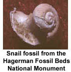
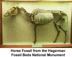
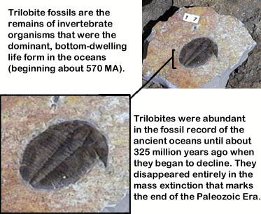
A fossil is the naturally preserved remains or traces of animals or plants that lived in the geologic past. There are two main types of fossils; body and trace. Body fossils include the remains of organisms that were once living and trace fossils are the signs that organisms were present (i.e. footprints, tracks, trails, and burrows).
 |
 |
 |
Two different modes of preservation include; preservation without alteration and preservation with alteration. Examples of the modes of preservation without alteration include: freezing, mummification and unaltered shell remains. Examples of modes of preservation with alteration include: permineralization which is the result of a chemical precipitating into the pore space; replacement which occurs when there is actual molecular exchange of substances that were once part of an organism with minerals carried in by percolating water solutions; and carbonization which occurs when soft tissues are preserved as films of carbon. Casts and molds are another type of fossilization where the physical characteristics of organisms are impressed in to the sediment prior to the formation of a rock. Molds are produced when shell material is progressively removed by leaching so at to leave a void in the rock bearing the surficial features of the original shell. Casts are produced when the void between the internal and external mold is filled with mineral matter; a cast becomes a model or replica of the organism.
Unlike fossils, which are the remains of organisms that lived in the past, an artifact is something that was made or modified by organisms that lived in the past - most typically humans. Artifacts provide archaeologists with a window of understanding into the history of human life and events, and our relationships to the natural world.
What is Plate Tectonics?
The theory of plate tectonics has revolutionized the thinking of geologists. This is a unifying theory that explains many seemingly unrelated geologic processes. Plate tectonics was first seriously proposed as a theory in the early 1960's although the related idea of continental drift was proposed much earlier.
The Plates
The outer part of the earth is broken into rigid plates approximately 62 miles thick. These outer plates are called lithosphere and include rocks of the earth's crust and upper mantle. Below the rigid lithosphere is the asthenosphere, a zone around the earth that is approximately 90 miles thick and behaves like a plastic because of high temperature and pressure. The lithosphere plates move over the plastic asthenosphere at a rate of an inch or more per year. Eight large plates and a few dozen smaller plates make up the outer shell of the earth.
The internal heat of the earth is the most likely cause of plate movement; this heat is probably generated by the decay of radioactive minerals.
The entire surface of the earth is moving, and each plate is moving in a different direction than any other. We now believe that plate movement is responsible for the highest parts of the continents and the deepest trenches in the oceans. Such movements also cause catastrophic events like earthquakes, volcanoes and tsunamis.
Plate Boundaries
Plate boundaries are of three types: a diverging plate boundary is a boundary between plates that are moving apart; a converging plate boundary is one where plates are moving towards each other; and a transform plate boundary is one at which two plates move past each other.
 Diverging Boundaries
Diverging boundaries occur where plates are moving apart. Most of these boundaries coincide with the crests of the submarine mid-oceanic ridges. These ridges form by ascending hot mantle material pushing the lithosphere upward. When heat rises, molten rock moves upward and the expansion from the heart and pressure causes the ridge plate to bow upward and break apart at the spreading centers. Tension cracks form parallel to the ridge crest and molten rock from magma chambers in the mantle is intruded through the fractures. Magma erupts into submarine volcanoes and some of it solidifies in the fissure. New crust forms in rifts at the spreading centers. As new magma is extruded, it accretes to both sides of the plates as they are pushed or pulled apart. As the plates continue to pull apart, new tension fractures form and fill with magma. This cycle repeats itself again and again.
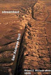
Transform Boundaries
The transform boundary occurs where two plates slide past one another. The San Andreas Fault is one of the best known land exposures of a transform boundary.
Converging Boundary
A converging boundary where plates move toward each other is responsible for the origin of most of Idaho's igneous rock as well as most of the major structural features of the state. Where one plate is covered by oceanic crust and the other by continental crust, the less dense continental plate will override the denser oceanic plate. The older the oceanic plate, the colder and more dense it is. Where two plates collide, the dense plate is subducted below the younger and less dense plate margin. At this boundary, a subduction zone forms where the oceanic plate descends into the mantle beneath an overriding plate. As the oceanic plate descends deeper into the earth it is heated progressively hotter. Also the friction caused by the two plates grinding past each other leads to greater temperatures.
At the subduction zones, submarine trenches form, representing the deepest parts of the ocean basins. Earthquakes continuously occur at the plate margins where the overriding plate is grinding and abrading the subducted laver. The subducted plate causes earthquakes all along its downward path as it slowly moves into the earth's mantle. By measuring the depth and position of the earthquakes, geologists are able to determine almost exactly the position and orientation of the subducting plate.
Age of Ocean Basins
The youngest rocks are found at the spreading centers, and become progressively older in both directions away from the spreading centers. The oldest rocks in the ocean basins are approximately 150 million years old as compared to the oldest rocks on the continents of 3.8 billion years.
Physical Properties of Oceanic Rocks
Rocks forming the ocean basins are dark, iron-rich and have a higher specific gravity than those forming the continents. Rocks of the continents tend to be low in density, light colored and rich in silica and aluminum. Because of the lower density of continental rocks, they are floating on the denser oceanic-type rocks.
Generation of Magma, Volcanoes and Batholiths
When the plate reaches a certain depth, the heat and pressure melts the lighter minerals within it. This light molten rock or magma coalesces at depth and floats upward through the more dense rock towards the surface of the earth. Where these globs of molten rock break through the oceanic crust, they form chains of volcanic islands. The Aleutian Islands are a well-known example.
The portion of the magma that manages to break through the surface forms volcanoes like Mount St. Helens and is classified as volcanic or extrusive rock. The portion that does not break through the earth's surface, but instead solidifies within the earth's crust, is classified as intrusive igneous or plutonic rock.
Where an oceanic plate is subducted below a continent, the rising globs of magma melt and absorb portions of the silica-rich, low specific gravity continental rocks. Where magma manages to break through the continental crust, the extrusive products are much more siliceous than their oceanic counterparts.
Geologists have found that rocks intruded through continental rocks have strontium isotope values much different than those intruded through oceanic rocks. Consequently, we are able to determine, on the basis of strontium isotope ratios, whether or not a particular intrusion passed through continental rocks.
Rocks in the vicinity of a subduction zone are drastically changed by the intense heat and pressure. If these rocks do not melt, they become metamorphic rocks. Also rocks in the continental crust in the path of a rising magma chamber are metamorphosed by the heat and pressure exerted by the upward-moving molten rock.
Mantle Plumes
Mantle plumes are believed to form where convection currents in the earth's mantle cause narrow columns of hot mantle rock to rise and spread radially outward. One of the most convincing theories for the origin of the Snake River Plain proposes that a hot mantle plume tracked across the plain from west to east and was the source for most of the volcanism in the Snake River Plain. This hot mantle plume is now thought to underlie the caldera at Yellowstone Park. Many of the volcanic islands of the Pacific Ocean may have originated from a mantle plume. The best known examples are the Hawaiian Islands.
The jigsaw-puzzle fit of continents bordering the Atlantic Ocean is a feature noted by scientists since the seventeenth century. Alfred Wegener called this supercontinent Pangaea and cited as additional evidence the similarity of geologic features on opposite sides of the Atlantic. The matchup of ancient crystalline rocks is shown by orange in adjacent regions of South America and Africa and of North America and Europe. (Geographic fit from data of E.C. Bullard; geological data from P. M. Hurley.)
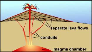
If lava is too viscous to spread out as a lava plateau, it builds up into a hill or mountain called a volcano.
Lava and rock fragments erupt from an opening called a vent. In many volcanoes the vent is located in a crater, a bowl-like depression at the summit of the volcano.
Volcanoes differ widely in shape, structure, and size.
 |
 |
 |
The ancient Greeks thought that earthquakes occurred when Atlas, the god who held Earth on his shoulders, shrugged. The Tzotzil Indians of southern Mexico believed Earth shook when a giant jaguar brushed up against the pillars of the world. In ancient Japanese tradition, earthquakes were caused by the flopping around of a giant catfish that lived inside Earth. In eighteenth century Europe, the pope declared that earthquakes were God's punishment for humanity's lack of faith.
Modern science has discovered that earthquakes occur when the internal forces of Earth are out of balance with those at it’s surface, sometimes resulting in surface ruptures and ground movement. These imbalances occur in many geological settings that result from the movement of lithospheric plates about Earth’s surface. The individual plates either converge (collide), or diverge (move away) and may do either at any angle to the plates bounding it, thus creating internal stresses. Another major cause is the movement of the plates over hotspots; which are areas where massive amounts of heat get transferred from Earth’s core. Rock melts when heat migrates upward, and the surrounding, weakened, lithosphere bends upward. Further faulting may occur after a volcanism when the volcano fall back into it’s empty magma chamber. Idaho contains much evidence for earthquake activity caused by tectonism and volcanism.
Why do animals seem to act so strangely before an earthquake?
It is quite common for animals to be seen engaging in bizarre behaviors right before an earthquake occurs. Examples of odd behaviors that have been observed include the following:
- Rats seem to panic and are afraid of people.
- Birds stay away from trees.
- Cockroaches scramble around as if they can't decide where to go.
- Pet goldfish swim around frantically
- Freshwater fish jump up wildly in lakes and ponds.
- Deer and rabbits run away from the future epicenter of a quake.
Animals are more sensitive to vibrations, magnetic fields, electricity, and odors than humans. This sensitivity may explain why they act so strangely before an earthquake. One theory suggests that just before a quake, microfractures are opening along the fault or stress zone. These are tiny ruptures occurring in surrounding rock, just before stresses reach the breaking point of an earthquake. It has been determined that the rupturing of microfractures actually can make very high pitched noises similar to shrieks. The sound is out of the human range of hearing, but could easily be heard by other, more sensitive species.
The Great Rift Zone
The Great Rift system consists of a series of north-northwest-trending fractures, which extend 50 miles from the northern margin of the eastern Snake River Plain, southward to the Snake River. In 1968, the Great Rift was designated as a national landmark.
The system has been divided into four separate sets of fractures. These four sets from north to south include: (1) the Great Rift set which trends N. 35' W. and cuts across the Craters of the Moon National Monument; (2) the Open Crack rift set which trends N. 30' W. and apparently has not experienced extrusive activity; (3) the King's Bowl rift set which trends N. 10' W; and (4) the Wapi rift set which is believed to trend north-south, but is covered by the Wapi flow. The total rift system is 62 miles long and may be the longest known rift zone in the conterminous United States.
Recent Volcanism of
the Eastern Snake
River Plain
Very fresh basalt can be found at five different locations: the Cerro Grande and other flows near Big Southern Butte; Hells Half Acre lava field near Blackfoot; Wapi lava field; Craters of the Moon lava field; and King's Bowl lava field. The last three originate from the great rift system. The younger flows lack vegetation so that they clearly stand out on aerial photographs.
King's Bowl Rift Set
The King's Bowl Rift set includes a central fissure with sets of symmetrical tension cracks on both sides. It is about 6.5 miles long, 0.75 mile wide and trends N. 10' W. The main fissure is about 6 to 8 feet wide and is mostly filled with breccia and feeder dikes. In certain areas it is possible to descend into the rift several hundred feet. King's Bowl, which was created by one or more phreatic eruptions, is the most prominent feature on the rift. The ash blocks and rubble around the crater are evidence for an explosive eruption. Well-developed pipe-shaped vesicles are exposed in a massive flow on the east wall of King's Bowl. These vertically aligned vesicles indicate the path of gas escaping from the base of the flow. The direction of the flow is indicated by the bend in the vesicles. These vesicles average about one-half inch in diameter.
Crystal Ice Cave
Crystal Ice Cave consists of natural and manmade passages through the King's Bowl Rift set. In this cave one can observe dikes, breccia zones and soil horizons between flows. The cave is named for the ice formation that developed from the freezing of surface water that seeped into the fissure. The King's Bowl lava field represents the last activity in the area and has been dated at 2,130 years.
Inferno Chasm
Rift Zone
The Inferno Chasm Rift Zone consists of a number of volcanic features all aligned along a rift trending N. 4' W. These features from north to south include Wildhorse Corral, Cottrell's Blowout, Inferno Chasm, Grand View Crater and possibly Papadakis Perched Lava Pond. All of these features are summit vents for coalescing lava shields.
Wild Horse Corral
Wild Horse Corral is an irregular-shaped depression about 3,070 feet long and 1,850 feet wide. The long axis is subparallel to the rift set. A flat terrace, approximately 165 feet wide, encircles the canyon walls and the crater floor. Wild Horse Corral may have started as two eruptions and coalesced into a single large fissure vent.
Bear Trap lava tube is situated west of Wild Horse Corral. This tube trends west-northwest for a distance of 3 miles, The Bear Trap lava flow probably came from the Wild Horse Coral vent.
A lava lake may have filled Wild Horse Crater periodically. After the lake was drained, the vent collapsed creating the present crater. The lava lake again filled and partially drained leaving a 165-footwide terrace around the crater walls.
Cottrell's Blowout
Cottrell's Blowout was started from a fissure vent along the Inferno Chasm Rift set. It is 1,950 feet long and 52 5 feet wide with a maximum depth of 140 feet. This feature was built by a succession of thin, gas-charged flows. Cottrell's Blowout formed as a result of a collapse to form a crater. The collapse was caused by the withdrawal of magma down the vent.
Inferno Chasm
This feature is an irregular circular vent 575 feet in diameter and 70 feet deep. It has a meandering lava channel that extends about 4,700 feet to the west.
Grandview Crater
Grandview Crater is a shallow depression that served as a vent for a lava shield near the southern end of the Inferno Chasm Rift Zone.
Papadakis Perched
Lava Pond
Papadakis Perched Lava Pond is the remnant of a former lava lake on the west side of the Inferno Chasm Rift Zone. It is a fan-shaped, shallow depression, approximately 3,800 feet long and 2,600 feet wide. The lava lake was fed by a spatter cone 2,000 feet west of the rift zone.
Split Butte
Split Butte, situated about 6 miles southwest of King's Bowl, is believed to be a maar crater. The name refers to a split or gap in the upper tephra layers at the east side of the butte. Prevailing west winds have caused the tephra ring to be asymmetrical. The winds caused more pyroclastic debris to be piled on the east side. The split, which is located on the east side is believed to be caused by wind erosion.
The tephra ring had an explosive pyroclastic phase. When the first flow erupted, it passed through ground water. This caused glassy ash to form due to the cold water coming in contact with the hot lava. After the water saturated sediments were sealed, pyroclastic activity ceased and a lava lake formed. The lava lake partly overflowed and then crusted over. After withdrawal of liquid lava below the crust, the central portions of the crust collapsed.
King's Bowl
King's Bowl is a crater 280 feet long, 100 feet across and 100 feet deep. It stands directly over the main fracture of the Great Rift. Kings Bowl crater is the source of the 2,222 year old King's Bowl lava flow. Immediately west of the crater is an ejecta field where large blocks of rubble blown from the vent are strewn all over the ground. The size of blocks decreases with distance from the crater. A field of squeeze-up structures nearby was caused by lava being squeezed up through fractures. Some are hollow indicating that lava was drained out shortly after formation. The ash and ejecta fields were caused by ground water coming in contact with lava upwelling from the vent.
Wapi Lava Field
The Wapi Lava Field is located at the southern end of the Great Rift System. The Wapi lava field is a broad shield volcano covering approximately 260 square miles. The cone consists of many aa and pahoehoe flows which are replete with lava tubes and channels. The Wapi lava field formed about 2,270 years ago, almost simultaneously with the King's Bowl lava field.
Sand Butte
Sand Butte is located 23 miles southwest of Craters of the Moon National Monument. Sand Butte first formed as a tuff cone and was later filled by a lava lake. It is situated on a 3-mile-long, north-southtrending fissure. The fissure ranges from 200 to 410 feet wide. Sand Butte, like Split Butte, was formed by the phreatomagmatic interaction of ground water and basaltic magma. Pyroclastic flow was the primary method of deposition. The basalt was erupted after the phreatic phase ended. This is demonstrated by tongues of spatter which overlie the tephra deposits. The final event was the partial filling of the crater by a lava lake. Finally the lava lake subsided to form a shallow crater.
Big Southern Butte
Big Southern Butte, Middle Butte and East Butte are three large buttes which can be seen rising above the eastern Snake River Plain while driving between Arco and Idaho Falls on Highway 20. All three buttes are situated east of the highway. Middle Butte appears to be an uplifted block of basalt. Although no rhyolite is exposed at the surface, the butte was probably formed by a silicic intrusion forcing the basalt upwards into the form of a butte. Big Southern Butte and East Butte are rhyolite domes. East Butte has been dated at 600,000 years, whereas Big Southern Butte has been dated at 300,000 years.
Big Southern Butte, because of its prominence and size, was an important landmark for the early settlers. It rises 2,500 feet above the plain and is approximately 2,500 feet across the base. Access to the top of the butte is available by a Bureau of Land Management service road. The butte was formed by two coalesced cumulo domes of rhyolite that uplifted a 350 foot section of basalt. The basalt section now covers most of the northern side of the butte. The dome on the southeastern side was developed by internal expansion (endogenous growth). Rupture of the crust at the surface caused breccia to form. Obsidian, pumice and flow-banded rhyolite are important components.
Once part of a continuous flow on the surface of the Snake River Plain, the large basalt block was pushed up and tilted by intrusion of the rhyolite. The basalt block now dips about 45 degrees to the northeast. This block consists of 15 to 20 individual flow units.
Lava Tubes
Lava tubes are important for the emplacement of lava on the Snake River Plain. Lava tubes are the subsurface passage ways that transport lava from a vent to the site of emplacement. They form only in the fluid pahoehoe flows. Tubes originate from open flow channels that become roofed over with crusted or congealed lava. However a tube may also form in a massive flow. Lava tubes exist as a single tunnel or as complex networks of horizontally-anastomosing tubes and may occupy up to five levels. Most tubes tend to be 6 to 13 feet across. Access to some tubes may be gained through collapsed sections. Features in tubes include glazed lava, lava stalactites and ice.
Great Rift Unrelated
to Basin and Range
Although many of the volcanic rift zones in the central and eastern Snake River Plain may be extensions of northwest-trending, range-front faults, the Great Rift does not appear to be a continuation of such a fault.
The Snake river Plain
The Snake River Plain is a prominent depression across southern Idaho extending 400 miles in an east-west direction. It is arc shaped with the concave side to the north. The width ranges from 50 to 125 miles with the widest part in the cast. This physiographic province was originally referred to as the Snake River Valley or the Snake River Basin. However, in 1902 F.C. Russell redesignated the province the Snake River Plains. Later the name was changed to Snake River Plain to convey a sense of uniformity throughout the province.
Although the east and west portions of the plain have little relief and are uniform topographically, there are major structural and geophysical differences between the east and west portions of the Snake River Plain.
The subsurface of the plain is known because of thousands of water wells and several deep exploration wells for geothermal resources and oil and gas. Geophysical surveys have also yielded much information on the subsurface.
Many different theories exist for the origin of the plain including a depression, downwarp, graben, and a rift. Although the plain is continuous, the surface geology and geophysical anomalies vary significantly among the western, central and eastern parts of the plain.
Western Snake
River Plain
The western Snake River Plain is 30 to 43 miles wide and trends northwest. It is a fault-bounded basin with both the land surface and the rock layers dipping towards the axis of the plain. The basin is filled by interbedded volcanic rocks and lake bed sediments of Tertiary and Quaternary age.
The deep wells drilled in the western plain show interbedded basalt and sediment. One well (Anschutz Federal No. 1) about 43 miles south of Boise passed 11,150 feet of alternating sediment and volcanic rocks before it terminated in granite. This granite may be a southern extension of the Idaho batholith.
Geophysical surveys used to interpret the Snake River Plain include gravity surveys, magnetic surveys, seismic refraction profiles, thermal gradient measurements and heat-flow measurements. There is a gravity high over the plain. This gravity high coincides well with the topographic low. The gravity high anomaly over the western plain is interpreted as indicating a thin upper crust. Seismic refraction data also support this interpretation. Seismic refraction profiles indicate that the total crust under the plain is more than 2 5 miles thick; however, the upper crust is thin under the axis of the plain. Heat-now measurements indicate a high heat flow anomaly along the margins of the plain and a relatively low heat flow in the central part of the plain.
Gravity and magnetic anomaly maps suggest several major strike-slip faults offsetting gravity and magnetic features in the plain. All geological and geophysical evidence indicates that the plain is bounded by normal faults. Also, there is no evidence of any pre-Cenozoic rock underlying the plain. It may not be proper to call the Snake River Plain a graben because there is no evidence that pre-Cenozoic rocks exposed north and south of the plain are downfaulted under the plain.
Middle Miocene (15 to 16 m.y. old) rhyolites and alkalic basalts are exposed in the Owyhee Mountains. These rocks are chemically and isotopically different than those of the Snake River Plain. North and northwest of Boise, Columbia River Basalt intertongues with sedimentary deposits of the Payette Formation. Idavada rhyolitic tuffs and ash flows 15 to 11 million years old were discharged from now buried calderas. The Idaho Group is composed of fluvial and lacustrine sediments with interbedded basalt flows deposited in a subsiding basin.
The Idaho Group includes the following formations:
Bruneau formation - 0.7 to 1.3 m.y. old
Glenns Ferry formation - 3 to 4 m.y. old
Chalk Hills formation - 7 to 8 m.y. old
Banbury Basalt - 8 to 11 m.y. old
Poison Creek formation
The Snake River Group consists primarily of basaltic lavas all less than 700,000 years old. Most of the vents of the Snake River Group are east of Twin Falls in the eastern Snake River Plain.
Central Snake
River Plain
The central Snake River Plain has a prominent gravity gradient that coincides with a magnetic high; however the margin of the central plain has no well defined topographic expression. Although much of the western plain is covered by sedimentary rocks, much of the central plain is covered by volcanics. The gravity anomaly suggests thinning. The western and central plain appear to have formed from regional tension normal to the trend of the western Snake River Plain.
Eastern Snake
River Plain
The eastern Snake River Plain trends northeasterly and is underlain by mostly silicic and basaltic volcanic with very little sediments. There is no significant fault control on the margins. The plain rises at the extreme east probably due to the proposed hot spot and associated volcanism recently moving from the Island Park Caldera to Yellowstone.
The land surface is higher at the margins than at the center, similar to the western plain. Both north and south of the eastern plain is the basin and range province with structures aligned approximately normal to the plain. The eastern plain is generally covered by Quaternary basalt flows with sources from fissures parallel to the plain, normal to the plain and along extensions of the basin and range faults.
In the eastern Snake River Plain, the gravity anomalies tend to be higher than surrounding areas. These anomalies exist as random highs and lows with no linear anomaly aligned with the axis of the plain. In fact gravity and magnetic anomalies generally trend normal to the axis of the eastern plain. These elongate anomalies trend northwest-southeast or approximately parallel to the trend of the basin and range.
The Idavada silicic volcanics in the eastern plain are similar to those in the western plain but are younger, ranging in age from 6.2 million years old to 10 million years old. At the northeast end of the plain, the last major eruption of the silicic volcanics is represented by the Yellowstone Tuffs dated at 0.6 to 2 million years old. The Yellowstone Tuffs are associated with caldera collapse followed by copious rhyolite flows erupted as recently as 700,000 years ago.
Large rhyolite domes 0.3 to 1.5 million years old rise above basalt near the axis of the plain. Rhyolite has been found in drill holes and at the margins of the plain. Abundant sediment is also found at the margins of the plain. Gravity and topographic evidence indicate a normal fault at the northwest boundary of the plain.
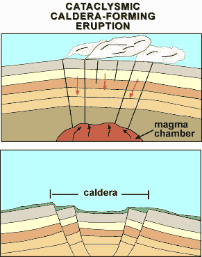
Caldera Complexes
The Island Park and Yellowstone caldera complexes are situated northeast of the eastern plain. The Rexburg caldera complex on the eastern plain has been identified and the existence of many others has been inferred. The silicic volcanic rocks in and near the Snake River Plain decrease in age from southwestern Idaho to Yellowstone National Park (Armstrong and others, 1975). This may mean that a source or center of silicic volcanics has and is progressively moving northeastward parallel to the axis of the plain. Seismic refraction profiles indicate that the eastern plain and the western plain have a thin upper crust and a thick lower crust. Silicic volcanic rocks and associated intrusive bodies apparently underlie most of the eastern plain. Rhyolite is far more abundant than basalt in the eastern plain - only a thin veneer of basalt lies over a thick sequence of rhyolitic ash and flow tuffs. It is very likely that many source calderas for rhyolite are buried below the basalts.
Island Park Caldera
The Island Park Caldera may be the largest symmetrical caldera in the world. Rhyolite was erupted during the initial collapse period. Then basalt and rhyolite were alternately erupted from vents along the caldera floor. Finally basalt was erupted. The tuffs, flows and fault scarps that make up the morphology of the caldera are so young that they have been modified very tittle by erosion. There were three basic phases in the evolution of the caldera:
1. growth of the volcano,
2. extrusion of magma, and
3. collapse.
The Island Park Caldera is an elliptical collapse structure 1 8 to 2 3 miles in diameter and is situated in the center of a rhyolite shield. The western semicircle of the scarp is exposed, and the eastern semicircle is buried under flows of rhyolite. Both basaltic and rhyolitic lava are believed to have originated from a single magma chamber below the caldera.
The rim crest of the southwestern side of the caldera stands about 1200 feet above the plain south of the caldera. The most abundant rock type composing the caldera is flow tuff, followed by ash falls and lava flows. The central portion of the caldera collapsed along a semicircular zone of faults 18 miles in diameter at the western half of the caldera
Tension Fractures
Heat flow in the eastern plain is similar to that in the western plain - low at the center and high at the margins. Many large fractures project inward from the margins of the eastern plain; large flows of basalt have been extruded from them. The fractures must go to sufficient depth to reach molten rock. The fractures are caused by tension parallel to the plain and could be related to regional extension of the basin and range. The Great Rift is one of the most prominent fractures; it includes Craters of the Moon lava fields.
Normal faults of the basin and range are apparently related to overthrusting at depth; evidence indicates that the planes of the normal faults flatten at depth to merge with thrust faults.
Subsidence or Downwarping
The western and central plain may be a downfaulted block something like a rift or graben. The downfaulting may have been caused by regional extension or possible clockwise rotation of a block south of the plain which thinned or parted the upper crust. Gravity and magnetic surveys indicate a thick layer of dense, strongly-magnetized rock formed in the depression. The western and central plains are continuing to subside because of cooling, tension, loading of sediment and isostatic adjustment caused by the dense thick layer beneath the plain.
The central Snake River Plain has features common to the eastern and western plains. Downwarping is the most significant structural activity in the eastern Snake River Plain.
Faults
Volcanic rift zones tend to be oriented along extensions of range-front faults and are caused by east-west extension. Basin and range faults are contemporaneous or younger than the Snake River Plain. These basin and range faults exist both north and south of the plain. This area has been under northeast-southwest extension during the last 17 million years.
Geophysical Characteristics
The entire Snake River Plain is underlain by a 25 mile-thick crust which is anomalously thick. The upper crust is thin relative to the average crust and the lower crust is thick relative to the average crust. Also the upper crust thickens to the east.
The near surface heat flow is relatively high throughout the Snake River Plain and particularly high at Yellowstone National Park. Cold ground water circulating throughout aquifers in the Snake River Plain reduces near surface gradients.
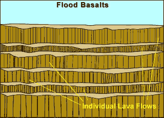
Basaltic Volcanism
The volcanic style of basaltic rocks in the eastern Snake River Plain is gradational between Hawaiian volcanism and flood basalt volcanism. For example, the Roza Member of basalt in the Columbia Plateau is typical of flood basalts. Approximately 350 cubic miles of lava were erupted from an 80-mile-long vent system at the rate of about 0.3 cubic mile per day. By comparison, the Hawaiian and Icelandic-type shield volcanoes are composed of thin flows 10 to 15 feet thick.
Basaltic Lava Flows
Most basalt flows in the Snake River Plains are pahoehoe basalts that were emplaced as compound flows. Compound flows are a sequence of thin individual cooling units ranging from less than 3 feet to more than 30 feet thick. The surface is hummocky with local relief, typically less than 30 feet. Common features are pressure plateaus, pressure ridges, flow ridges and collapse depressions. These features are caused by the way in which flows advance through a series of budding pahoehoe toes. Low areas and swales are filled with wind-blown sediments so that now, on the surface of older flows, only the higher ridges are visible. Aa flows are not as extensive as pahoehoe flows and can best be seen at Craters of the Moon. Basaltic lava is extruded on the Snake River Plain in three ways: flows from a central vent forming low shields, fissure flows and tube-fed flows.
Low Shields
Low shields are characterized by a small size and low profile, They have slope angles of 0.5 degrees and average 10 miles across and less than 1.6 cubic miles of lava. An excellent example is the Wapi lava field.
This field covers 116 square miles with compound lava flows of pahoehoe. It is characterized by features such as lava toes, collapse depressions, flow ridges and pressure ridges, but lacks lava tubes. The Wapi lavas have a carbon 14 date of 2,270 years. Many of the low shields have pit craters at the summit and many craters show evidence of collapse. Shields tend to be aligned along rifts or fissures.
Fissure Flows
Fissure vents are associated with rift zones. The youngest fissure flows on the Snake River Plain are located at Kings Bowl and the Craters of the Moon National Monument. Craters of the Moon covers 580 square miles whereas Kings Bowl covers about 1 square mile. Flow thickness is generally less than 5 feet although ponding or lava lakes may cause thicker layers. Point source eruptions along a fissure are common. For example, spatter cones and cinder cones at Craters of the Moon are examples of point source eruptions.
Lava Tube Flows
Lava tubes and channels originating from fissures and low shields are a very major conveyance for the emplacement of lava. These tubes are commonly more than 12 miles long and range from 2 to 30 feet across.
Shoshone Ice Cave is a segment of a complex lava tube - lava channel system, i.e. a system that had both roofed and unroofed segments. Many of the roofed parts later collapsed. The Shoshone lava tube system covers approximately 80 square miles. Smaller subsidiary tubes removed lava from the main tube.
Snake River Group
The Snake River Group includes most of the basalt flows in the Snake River Plains that were extruded during the Pliocene to Holocene epochs. The youngest flows are no more than a few thousand years old and the oldest are about four million years old. Approximately 8,000 square miles of southern Idaho are covered by basalt flows and interbedded sediments of the Snake River Group.
Geophysical studies and drill holes indicate that the plain may be underlain by basalts as much as five miles thick. However 5,000 feet may be an average thickness. Because only the upper 1500 feet were sampled by drill hole, it is possible that some of the basalts not reached by the drill hole are flows of the Columbia River Group.
The Snake River Basalts tend to be extruded from central vents rather than fissures. In the Snake River Plain there are numerous small shield volcanoes 200 to 400 feet high. On a clear day, from almost any place on the Snake River Plain, one can see low hills on the horizon that are either cinder cones or shield volcanoes of basalt. Menan Buttes in western Madison County is an example of a recent cinder cone. At Craters of the Moon National Monument, very recent flows and volcanic structures can be examined.
Look at views of the three landmark eastern Snake River Plain buttes:
* Big Butte
* Middle Butte
* East Butte
Idavada Volcanics
The name Idavada volcanics is applied to a variety of silicic volcanic rocks that crop out in the vicinity of the western Snake River Plain. These silicic rocks include primarily welded ash-flow tuffs; however, also included are vitric tuffs and lava flows. The type locality is Idavada, a place near the intersection of U.S. highway 93 and the Idaho-Nevada State line. Along Goose Creek, a section of silicic tuffs more than 3000 feet thick is exposed. On the north side of the Snake River, a thick section of the Idavada volcanics lies unconformably on granite and makes up most of the Mount Bennett Hills. For example, the scenic Gooding City of Rocks, located in the Bennett Hills, is made up of Idavada silicic volcanic rocks. Pinnacles, bizarre forms and hoodoos are typically formed by differential weathering and erosional processes on the Idavada volcanics. Balanced Rock, south of Twin Falls, is also composed of these volcanics and is a good example of the same weathering phenomenon. The Idavada volcanics also border the southern edge of the Snake River Plain in Cassia, Twin Falls and Owhyee Counties.
The Idavada volcanics are of Miocene age, ranging from 9 to 14 million years old. The flows are oldest in the western Snake River Plain and are consistently younger to the east.
Origin of the
Snake River Plain
The central and eastern plain is apparently a structural downwarp because strata along the flanks dip towards the center; also there is little evidence for boundary faults. By contrast, the area in the vicinity of Yellowstone appears to be experiencing uplift. This eastward propagation of volcanism may be caused by the migration westward of the continent at a steady rate over a deep mantle plume or hot spot rooted more than 100 miles below the surface. Several hypotheses exist to explain the origin of the Snake River Plain:
1.Extension to the north coupled with crustal thinning.
2.Migration of the continent or the North American plate over a stationary hot spot which now exists at Yellowstone National Park. The hot spot has a northeastward migration of silicic volcanic centers moving at the rate of 1 to 2 inches per year. Uplift is associated with volcanism and silicic volcanism is followed by basaltic volcanism. The lower crust is thickened and made more dense by injection of basaltic magma. After passing over the hot spot, the crust settles due to contraction from cooling and the density of the basalt. This hypothesis is favored.
3.Propagation of crustal fracture from west to east.
4.Passive deformation.
Geologic Model
for Snake River
Plain Volcanism
Basalt magma formed in the mantle moves upwards because it is less dense than surrounding mafic mantle rocks. However basaltic rock is denser than crustal rock so the basaltic magma column must extend deep enough into the mantle to allow hydrostatic pressure to force it up through the lighter crust. The basaltic magmas probably originated at a depth of approximately 40 miles. The initial basaltic magmas probably stagnated in the deep crust- however, repeated injection of more magma led to a large magma chamber and a thicker lower crust. During the accumulation of basaltic layers, heat transfer to the crustal wall rocks would cause partial melting (anatexis) of the more silicic crust.
The zone of partially fused wall rocks continues to enlarge as basalt is added. Because partial melts of silicic magmas are less dense than the basaltic magmas, they would tend to coalesce and move higher in the crust to form magma chambers at about 6 miles deep. Intermediate to silicic magmas would continue to differentiate and interact with wall rocks as well as hydrothermal fluids. These magmas would raise the temperature of the crust and the heat would cause the crust to expand and result in regional uplift.
Numerous eruptions of ash-flow tuffs occur during caldera collapse; after collapse, resurgent doming takes place and the cycle is repeated many times. Small rhyolite domes extruded after the main rhyolitic phase represent the residual components of the original silicic bodies. As long as the silicic magma bodies existed as fluids, fissures could not propagate to allow the basaltic magmas to pass. Rhyolitic volcanism ceases with solidification of the silicic magma.
Three Time
Transgressive Facies
Throughout the Snake River Plain there are three time transgressive facies of volcanic rocks. This means that a similar rock such as the Idavada volcanics is found throughout most of the Snake River Plain but is younger from west to east. These three facies include:
1.Silicic volcanic facies composed of volcanic sediments, air-fall and ash-flow rhyolite tuffs, rhyolite flows and subordinate basaltic flows.
2 .Basaltic lava facies with interbedded sediments; a few rhyolite flows and domes overlap.
3 .An uppermost facies of continental sediments, basaltic lavas, rhyolitic ash-flow and air-fall tuffs.
The Snake River Plain is a broad west-draining lava plateau, with mountains on its north and south sides. The Plain has the shape of a broad "V" and is divided into eastern and western parts, which meet near Hagerman, just west of Twin Falls.
The Snake River drains southwestward, fed by drainage off the Yellowstone Plateau, located above the Yellowstone-Snake River.
The eastern Snake River Plain is a northeast-trending lowland underlain by rhyolitic volcanic fields with nested calderas less than 12 million years old, and a thin cover of basalt less than 2 million years old. The volcanic fields are progressively younger to the northeast towards the Yellowstone Plateau, reflecting the southwest movement of the North American plate over a fixed mantle plume. The eastern plain is bounded by steep north - northwest - trending Basin and Range mountains, with agricultural valleys between.
Through the last 12 million years, a dome-shaped topographic high moved northeastward ahead of the hot spot. This elevated bulge was inflated by hot-spot derived thermal energy. As the highland moved northeastward, drainage flowed radially away from it, mainly to the south, north, and east. As the bulge subsided, the west-flowing Snake River captured drainages like the Portneuf and Big Lost Rivers, and the Snake River Plain formed. The movement of the bulge also caused the continental divide to migrate eastward.
The western Snake River Plain is a north - northwest - trending 10 million year old basin bounded by normal faults. It is filled with thick sequences of basalt lava, sediments of Lake Idaho, and stream deposits derived from the Idaho batholith to the north and the Owyhee Mountains to the south. Both arms of the Plain appear to have been strongly shaped by extension of the crust on the North American Plate during the past 17 million years.
Idaho Batholith
The Idaho Batholith is a composite mass of granitic plutons covering approximately 15,400 square miles in central Idaho. The outer perimeter of the batholith is irregular and in plan view it has an hourglass shape. It is approximately 200 miles long in the north-south direction and averages about 75 miles wide in an east-west direction.
Age of Batholith
Armstrong and others (1977) called the northern part of the hourglass the "Bitterroot" lobe and the southern part the "Atlanta" lobe. He also proposed that most of the southern lobe was emplaced 75 to 100 million years ago (Late Cretaceous); whereas the northern lobe was emplaced 70 to 80 million years ago. Armstrong (1977) further noted that older plutons of Jurassic age occur on the northwest side of the Bitterroot lobe and many Eocene plutons have intruded the eastern side of the Atlanta lobe of the batholith. On the western side of the batholith, there are more mafic plutons (quartz diorites or tonalites) than to the east.
Radiometric dates and field relationships, where plutons of the batholith cut older rocks, restrict the age of the Idaho Batholith to an interval between 180 million years ago (Late Triassic) to 45 million years ago (Eocene); however, the dominant interval of emplacement was Early to Middle Cretaceous. There is a general west-to-east decrease in age for plutons of the batholith.
Rock Composition
The western margin of the Atlanta lobe is strongly folded and metamorphosed into gneissic rocks which are well exposed near McCall. The largest pluton mapped to date is a quartz monzonite in the vicinity of Warm Lake. It is about 124 miles in a north-south direction and more than 30 miles wide. However, many of the plutons of the batholith have not been delineated by geologic mapping.
Both lobes of the batholith have a different composition on the west than the east side. On the west side the rocks are tonalites or quartz diorites, whereas on the east side they range from granodiorites to granites. The boundary between the two composition types also coincides with the 0.704 Sr87/Sr 86 boundary and also the boundary between the Mesozoic and Paleozoic eugeoclinal accreted rocks on the west with the continental Precambrian rocks on the east side (Hyndman, 1985).
According to Hyndman, (1985), the tonalites on the west side originated by the melting of oceanic rocks near the subduction zone. Evidence that these tonalites were derived from oceanic rocks and have not been contaminated by melting of continental sedimentary rocks include: (1) low Sr isotope ratios, (2) low SiO2, and K20, (3) high FeO-MgOCaO, and (4) 13 to 30 percent mafic minerals. Hyndman (1985) further proposed that the granodiorite and granites on the east side originated by melting of Belt Supergroup or pre-Belt continental crustal rocks. These continental sedimentary rocks were melted by hot mafic magmas rising from the same subduction zone that produced the tonalites. Evidence that the granodiorites and the granites on the east side contain substantial melted continental sedimentary rock include: (1) high Sr isotope ratios, (2) high SiO, and K20, (3) abundant muscovite-orthoclase-quartz minerals, and (4) rounded zircons dated at 1700 to 1800 million years derived from the continental crust of pre-Belt age.
Bitterroot Lobe
Hornblende-biotite tonalite and quartz diorite plutons were emplaced at mesozonal levels in the western and northwestern margin of the Bitterroot lobe. According to Toth (1985), plutons were small and isolated igneous-type granites and were intruded during regional compression in the Cretaceous (105 to 86 m.y. ago). Later, during Paleocene time, plutons of foliated muscovite-biotite granodiorite and monogranite plutons were intruded. These plutons of sedimentary-type granites, are chemically similar and represent most of the bitterroot lobe. Toth and Stacey (1985) place the period of intrusion to be 70 m.y. ago to 50 m.y. ago, with most plutons intruded between 65 to 50 m.y. ago. Toth (1985) also observed large plutons and dikes of diorite in the southern and central parts of the Bitterroot lobe. These dikes are derived from the mantle and may have provided some of the heat necessary to cause partial melting of the crust to form the sedimentary-type granites of the Bitterroot lobe.
Atlanta Lobe
From the west side to the core there is an increase towards the east in Si02 and a decrease to the east in CaO, MgO and Al203. From the core to the east side there is less SiO2 and more CaO, MgO, and Al203. The western side is composed of tonalite 95 to 8 5 million years old. The batholith core is biotite granodiorite; and the eastern side of the lobe is muscovite-biotite granite approximately 76 to 72 million years old.
Initial Isotope Ratios
Rocks in western Idaho have very different initial Sr 87/Sr 86 ratios. All the plutonic rocks west of the dashed line have low initial ratios (0.7043) whereas, all rocks to the east of the line have high initial ratios (0.7055). This change in ratios is abrupt and remarkable. In Idaho, the change is made in less than a distance of 6 miles. Although there is no difference in petrology of the rocks on either side of the line, there is a difference in the geologic environment in the two areas. For example, the low ratios are measured where plutons are intruded into Paleozoic or Mesozoic eugeoclinal rocks on the west side of the line. East of the line where the initial ratios are high, the plutons were intruded into Precambrian rocks. In some areas, the existence of Precambrian rocks are inferred because of cover by more recent volcanic or sedimentary rocks. Armstrong (1977) suggests that the high ratios of the plutons east of the line were caused by the assimilation of large quantities of crust by magmas ascending from the mantle. Conversely, west of the line, magmas ascending from the mantle rise through young crust which has not had sufficient time to be enriched in Sr87. Therefore, plutons will form with low ratios. Armstrong (1977) speculates that the variability of the initial ratios of plutons east of the line indicates assimilation of rocks ranging in age from 500 million to as many as 2.7 billion years old. Therefore, the dashed line drawn to represent the change in initial ratios also represents the boundary between the Paleozoic and Mesozoic eugeocline and the older Precambrian crust. The dashed line also marks the suture line along which the Paleozoic and Mesozoic rocks were accreted onto the North American continent during the Mesozoic.
In the vicinity of Orofino, the isotopic boundary turns abruptly due west into eastern Washington. The trans-Idaho discontinuity (Yates, 19 68) is also thought to transect the area near Orofino in a west-northwest trend. On the basis of field observations and geophysical evidence, Armstrong and others (1977) proposed that the trans-Idaho discontinuity changes direction near Orofino and follows the isotopic boundary for more than 60 miles. This portion of the trans-Idaho discontinuity may have been a transform fault active in Late Precambrian time. Stewart (1972) proposed that the onset of north-south rifting in Late Precambrian time initiated the Phanerozoic Cordilleran geosyncline.
Central Batholith
Lund (1985) proposed that in the central part of the batholith, plutons were emplaced passively after tectonism and that the intrusion of plutons did not cause orogenesis but were post orogenic. Events affecting the central part of the batholith occurred in the following order:
1. 95 to 85 m.y. ago:
deformation at the suture zone; tectonism caused suturing of the island arc.
2. 85 to 75 m.y. ago:
undeformed tonalite and granodiorite plutons emplaced.
3. 75 to 70 m.y. ago:
undeformed muscovite-biotite granite passively emplaced into tonalite and metamorphic rocks.
Dike Rocks in
the Batholith
Pegmatite and aplite dikes were formed during the late stages of each plutonic intrusion. The mineralogy of the dikes is similar to the enclosing intrusive. In some cases, pegmatite dikes cut aplite dikes and in other cases the reverse is true. These dikes appear to be concentrated near Eocene plutons and occur in the northeast-trending, trans-Challis fracture zone.
According to Foster (1986), the Bitterroot lobe of the Idaho Batholith contains numerous mafic dikes which make up about 20 percent of the total rock. These tabular dikes average about 8 feet thick and trend east-northeast with a vertical dip. On the basis of field evidence, Foster believes the dikes were emplaced while the batholith was still hot.
Emplacement
of Plutons
Each pluton rises as a tapered cylindrical body. As a pluton is emplaced, both its outer margin and the surrounding country rock become deformed. Therefore the foliation adjacent to a pluton is generally conformable to its boundaries and to the foliation within the pluton.
Rock in and just above the zone of pluton generation are high-grade gneisses and migmatites (mixed igneous and metamorphic rock). These rocks have near-horizontal foliation. The overlying zone which is 3 to 10 miles deep, is volumetrically expanded by pluton emplacement. This expansion causes the underlying crustal zone to be extended laterally by plastic flow causing itself to be thinned and flattened.
In some Precambrian shield areas, there has been sufficient uplift and erosion to see exposures of gneisses with subhorizontal foliation. The shallow crustal level above the zone of lateral compression is subjected to horizontal tension both from the upward pressure caused by the rising pluton and the lateral movement outward of the rocks in the zone of compression. Therefore the upper crustal rocks are .pulled apart into large fault blocks.
The boundary between the upper crustal roof rocks and the zone of pluton emplacement is a plane or zone of decoupling by low-angle faulting. The rocks in the lower zone of emplacement deform as a plastic whereas the upper crustal roof rocks deform as a brittle material. Upon decoupling, upper crustal roof rocks slide away in every direction (Gastil, 1979).
Field Identification
of Granitic Rocks
Granitic outcrops of the Idaho Batholith are easily recognizable in the field. Under close inspection, granite has a salt and pepper appearance with the dark minerals of biotite mica and hornblende and light minerals of plagioclase and quartz. The constituent minerals are up to an inch or more in diameter and can readily be identified without a hand lens. Of course, many minor accessory minerals are too small to be identified with the unaided eye.
Weathered outcrops of granite have a distinctive appearance and can in some cases be identified at a mile or more distance. Coloration tends to be very light gray to very light tan, and in some places chalk white due to leaching by hot water. Outcrops are generally smooth and rounded due in part to surface weathering by granular disintegration and in some cases exfoliation where layer after layer is removed from the surface. Most exposures are cut by one or more sets of fractures which may give the outcrop a blocky appearance. Granite and basalt are among the easiest rocks in Idaho to identify.
Accreted Terrane
Most of the pre-Cretaceous rocks west of the Idaho Batholith in west central Idaho and east-central Oregon are oceanic or island arc assemblages. These rocks were formed offshore in island arcs and adjacent basins (Vallier, 1967, 1977; Brooks, 1979) and were accreted to the North American continent between Late-Triassic and mid-Cretaceous time. This means that before Jurassic time, the West Coast of North America was situated near Riggins, Idaho.
The Suture Line
Pre-Cenozoic rocks near the western boundary of Idaho fall into one of two settings. These two settings are separated by the strontium-isotope line. All the plutonic rocks west of the dashed line have low initial ratios (<O.7043); whereas, all rocks to the east of the line have high initial ratios (> 0.7055). This change in ratios is made in less than a distance of 6 miles. The strontium - isotope line therefore represents the suture line where the accreted island arc assemblages were welded to western North America.
Paleozoic sedimentary rocks overlying Precambrian rocks of the continent make up the miogeocline on the east side of the suture line. These sedimentary rocks have been intruded by the batholith. On the west side of the line is a complex assemblage of rock derived from oceanic crust and portions of an island arc. The ages of this accreted assemblage ranges from Devonian to Early Cretaceous. Granite plutons intruded the accreted terrane; and later, Late Cretaceous marine strata covered portions of the accreted terrane, which were depressed as a shallow basin.
Four Smaller Terranes
The oceanic and island arc terrane is divided into four smaller terranes: (1) the dismembered oceanic crust terrane or melange, (2) the Wallowa Mountains-Seven Devils Mountains volcanic arc terrane, (3) the Juniper Mountain-Cuddy Mountain volcanic arc terrane (may be a southern extension of the Wallowa-Seven Devils volcanic arc), and (4) Jurassic Flysch terrane of forearc basin marine sedimentary rocks. All four terranes are separated by major unconformities and faults and were intruded by plutons of Late Jurassic and Early Cretaceous age. These terranes were formed in the eastern Pacific Ocean, far from their present position, and were transported on lithospheric plates to be accreted on the edge of the continent.
Oceanic Crust Terrane
The dismembered oceanic crust terrane has undergone extreme deformation that is characteristic of tectonic melanges. This tectonic disruption probably happened in Late Triassic time. The oceanic crust terrane includes mafic rocks (ophiolite), metamorphosed chert, argillite, tuff, lava flows and limestone that ranges in age from Devonian to Middle Triassic. It includes the Canyon Mountain Complex, Elkhorn Ridge Argillite and Burnt River Schist of eastern Oregon and the lower part of the Riggins Group of western Idaho. Fossils and other evidence indicate that rocks derived from a deep ocean environment as well as from shallow water are mixed together.
Volcanic Arc Terranes
The Wallowa Mountains-Seven Devils Mountains volcanic arc terrane includes the Lower Permian and Middle and Late Triassic volcanic rocks of the Seven Devils Group and the Clover Creek Greenstone. This terrane also includes overlying Late Triassic and Early Jurassic marine sedimentary rocks of the Martins Bridge, Hurwal and Coon Hollow Formations and the Lucille Slate.
The Juniper Mountain-Cuddy Mountain volcanic arc terrane includes assemblages of metamorphosed basalt, andesite, dacite and rhyolite flows that are interlayered with marine sedimentary rocks. The two volcanic arcs are separated by layers of Cenozoic age so their relationship is not known. The volcanism that created the two arcs ended in Late Triassic. Both arcs may represent different parts of the same arc or it is possible that the two terranes represent two different arcs with different origins. Based on structural and stratigraphic similarities it is probable that the volcanic terranes are different parts of the same arc.
The volcanic arc terranes are similar to the accreted island-arc terranes termed Wrangellia that lie between Alaska and Vancouver Island. However, based on the composition of volcanic and sedimentary rocks, the accreted terrane in Idaho is not related to the Wrangellia terrane.
The Jurassic Flysch
Flysch is defined as thin bedded, poorly sorted, deep water sandstone and mudstone rapidly deposited, usually during an orogenic pulse. The Jurassic Flysch accreted terrane includes siltstone, argillite, slates, phyIlites, volcanic wacke, arkosic wacke, limestone and conglomerate. Poor sorting, angular grains and rock fragments are common to these rocks. The Squaw Creek Schist, Fiddle Creek Schist, Lightening Creek Schist and the Berg Creek Amphibolite of the Riggins group are representative of the Jurassic Flysch.
The Flysch is situated between the volcanic arc and the oceanic crust terrane and is believed to have been compressed against the arc by the oceanic terrane. Deposition of the flysch probably ended in the Late Jurassic. The oceanic terrane and the volcanic arc terrane were sutured in Late Triassic and Early Jurassic time and the Flysch derived from the volcanism was deposited along the suture.
Continent-Island
Arc Juncture
The continent-island arc juncture in west-central Idaho is narrow and well defined. Lund (1984) has recently described the geological character of this juncture or suture zone. On both sides of the suture, the metamorphic grade increases to amphibolite facies near the juncture. The suture zone lacks many of the features of a typical subduction zone. It is an abrupt, nearly vertical juncture between the continental metasedimentary rocks of Paleozoic to Middle Proterozoic age on the east side of the metamorphic rocks of the Permian - Triassic Seven Devils island arc and the overlying Riggins Group on the west. No transitional metasedimentary rocks with a marginal basin exists at the suture zone as is common for other known suture zones. According to Lund (1984), the suture was made by a convergent, right-lateral fault that sliced away the edge of the continent and then brought slabs of exotic oceanic (accreted) terrane in from the southwest.
Deformation and
Time of Accretion
The accreted terrane was deformed in the Late Triassic and again in the Late Jurassic. The Late Triassic deformation occurred following deposition of most of the volcanic rock units. The time of the accretion is estimated to have occurred 118 million years ago (Lund, 1984; Sutter and others, 1984). Deformation and metamorphism of the Riggins Group at the contact with continental rocks occurred at that time However, the accretion process probably occurred over a period of time ranging between Late Triassic and mid-Cretaceous. During this time and for a period afterwards, the Idaho Batholith was formed by magmas generated from subduction of the eastward moving plate.
Idaho Earthquakes
The crust of the earth is constantly moving. However, with the exception of faults accompanied by earthquakes, this rate of movement is far too slow to notice. In the mountain ranges of Idaho, movement generally occurs at a much higher rate than it does in the more stable interior of the continent.
The movement of a part of the crust creates a stress. A stress is a force that is applied to a body of rock in such a way as to change its shape or size. The body of rock affected may range from microscopic to continental in size. The adjustment to the body of rock is called strain. Strain, then, is the adjustment of the rock unit in response to stress. Stress may be
(1) compressive, which shortens the rock body,
(2) tensional, which elongates the rock body, or
(3) shear, where the forces are parallel but in opposite directions.
In solid material like rock, stress can cause three types of strain or deformation: plastic, elastic and fracture. In plastic deformation, the rock is molded or changed in shape under stress and does not return to its original shape when the stress is released. For example, silly putty changes shape when squeezed between your fingers and does not return to its original shape when the pressure is released. This is an example of plastic deformation. In elastic deformation the rocks may partly return to their original form after stress is released. If the rock responds to stress by cracking or fracturing, it breaks. Common examples of fractures are faults and joints. Typically, rocks initially yield to stress plastically and then fracture. In most cases the movement of rock is very slow, generally several millimeters or less per year.
Strike and Dip
Strike and dip are two terms used to describe the extent and direction of tilting of fractures and layering (bedding and foliation) of rock. This is determined by relating the inclined surface to an imaginary horizontal plane.
Strike is the compass direction of a line formed by the intersection of an inclined plane (tilted bedding or fault plane) with an imaginary horizontal plane. Dip has two components: the angle of dip is measured downward from the horizontal plane to the bedding the direction of dip is the compass direction in which the angle of a dip is measured. The dip would be the direction a ball would follow down a tilted surface. The dip angle is always measured at right angles to the strike. Geologists use the symbols ![]() to denote strike and dip, the strike is the long line and the short line indicates the direction of dip. A small number beside the symbol indicates the angle of dip. In this case the tilted bed is dipping 40 degrees from the horizontal. Geologists use a specially designed compass called a Brunton to take these measurements.
to denote strike and dip, the strike is the long line and the short line indicates the direction of dip. A small number beside the symbol indicates the angle of dip. In this case the tilted bed is dipping 40 degrees from the horizontal. Geologists use a specially designed compass called a Brunton to take these measurements.
Block diagram shows relationship of strike and dip to a horizontal plane.
Folds
Folds are bends in rock layers generally caused by compression. Typically there are a series of arches (upfolds) and troughs (downfolds). This type of deformation is plastic so the rocks were probably buried deeply in the earth's crust when the folding occurred. High temperatures and pressures deep in the crust allow rocks to deform as a plastic rather than break. On the other hand fractures such as faults and joints occur near the surface where the rock is cold and brittle. Therefore you can see that the type of deformation, plastic or fracture, indicates the level in the crust where the deformation occurred.
Several terms are necessary to describe and interpret a series of folds. An anticline is an upfold or arch and where layers dip away from the axis (or hinge line). A syncline is a downfold or arch. Synclines and anticlines are typically plunging folds. In a plunging fold the axes are not horizontal. In a dome, the beds dip away from a central point and in a structural basin the beds dip towards a central point. Folds exist in all sizes from microscopic to more than a half mile in height. basic types of folds include: open folds - caused by mild compressional stress isoclinal folds - caused by intense compressional stress; limbs of the fold are parallel. Overturned folds - the limbs dip in the same direction recumbent fold - overturned to such a degree that the limbs are nearly horizontal.
Fractures
If a rock is brittle, it may rupture or break under stress. Most rock near the earth's surface is brittle so almost every exposure of bedrock is cut by fractures. There are two types of fractures in rock: joints and faults. A joint is a fracture along which no movement has taken place. Tensional forces generally cause joints. A fault is a fracture or break in the rock along which movement has taken place. The rupture and subsequent movement may be caused by tensional, compressional or shear forces.
Joints
Joints are fractures in rock where no displacement has occurred along the fracture surface. Columnar jointing is a specialized type of jointing common to volcanic flows. Hexagonal columns form in response to contraction of a cooling lava flow. Exfoliation (or sheeting) is another specialized type of joint generally caused by expansion parallel to the weathering surface. Where closely spaced joints are parallel, they make up a Joint set. These Joints may be spaced from several inches to tens of feet apart. Typically rock exposures exhibit two or more joint sets. The study of joints is important for site evaluations for dams because jointing can affect the permeability and strength of the rock. Joints are also important as a plumbing system for hot water systems and the emplacement of mineral deposits.
Faults
Faults are fractures in rock along which movement has taken place parallel to the fracture plane. Many faults are active; that is, movement has taken place during historical times. Where faults are exposed in bedrock the geologist looks for evidence of displacement or offset features to determine the amount of displacement and the relative direction of movement. Fault planes or zones vary considerably in thickness. Some are just a thin crack in the rock, whereas others may consist of a brecciated and sheared zone up to 1,000 feet wide. Faults also range in length from several feet or less to hundreds of miles. For example the San Andreas Fault extends about 620 miles through western California, slowly moving Los Angeles toward San Francisco. The current rate of movement averages about one inch per year so it will take about 25 million years to make Los Angeles a western suburb of San Francisco. During the 1906 earthquake that devastated much of San Francisco, bedrock along the fault was displaced as much as 15 feet. This was determined by measuring the amount of displacement along features such as roads and fences offset by the fault. The total displacement along the fault is probably about 300 miles since movement began about 30 million years ago.
Types of Faults
The three major types of faults include normal or gravity faults, reverse or thrust faults and strike-slip or transcurrent faults.
A normal fault is one along which the hanging wall has moved down relative to the footwall. The fault plane of normal faults typically dips at an angle of 60 degrees from the horizontal. The normal fault is the most common type of fault that you can expect to see in the field. The largest and most impressive group of normal faults are those that form the fault blocks that make up the Basin and Range Province of eastern Idaho. Normal faults are caused by rupture in response to tensional forces. Because the rock is pulled apart rather than pushed together, the broken area has much space available for ore solutions to move in and precipitate. Most lode or vein deposits are formed in normal fault zones.
In a reverse fault, the hanging wall moves up relative to the footwall. The fault plane is typically inclined 30 degrees from the horizontal, but may vary significantly from this. Reverse faults are not nearly as common as gravity or normal faults.
A thrust fault is a type of reverse fault that is characterized by a low angle of inclination of the fault plane. In fact the fault plane is commonly horizontal or subhorizontal. Both reverse and thrust faults are caused by rupture in response to compressional forces. Eastern Idaho has many exceptional examples of large thrust faults where the upper plate has moved from west to cast tens of miles placing older rocks over younger rocks.
A strike-slip fault is one along which the movement has been parallel to the strike of the fault plane and is caused by rupture in response to shear forces. If an observer looks along the strike of a left-lateral, strike-slip fault, the relative movement has been such that the left-hand side has moved towards the observer. Along a right lateral, strike-slip fault, the block on the right has moved towards the observer.
Earthquakes
An earthquake is a shaking of the ground caused by a sudden release of energy stored in the earth's crust. This happens when stresses build up in certain parts of the crust until suddenly a rupture (fault) occurs and energy waves are sent out through the earth. Volcanic activity can also cause earthquakes. These energy waves sent out by an earthquake are called seismic waves. The movement of the seismic waves through the ground during an earthquake causes the ground to shake. The focus of an earthquake is the point within the earth where seismic waves originate. The focus is normally centered on the part of a fault that has the greatest movement. The epicenter of an earthquake lies on the earth's surface, directly above the focus.
Measuring an Earthquake's Size
The size of an earthquake is directly related to the amount of energy released at its focus. Two parameters are used to show the size of an earthquake: magnitude (energy released), and intensity (damage caused). The American seismologist, Charles F. Richter, devised the Richter scale to measure the total amount of energy released by an earthquake. This scale, which is recorded by seismographs, is quantitative and measures a quake independently of its effects. The Richter Scale uses numbers from 1 on up to describe magnitude. Each number represents an earthquake ten times stronger than the next lower number. For example, an earthquake with a magnitude of 5 is ten times stronger than an earthquake with a magnitude of 4. An earthquake with a magnitude of 7 or higher is a major quake. The strongest earthquake on record had a magnitude of 9.5 on the revised Richter Scale (Chile, 1960). The 1906 San Francisco earthquake registered 7.9 on the revised Richter Scale and the 1983 eastern Idaho Borah Peak earthquake had a magnitude of 7.3.
The modified Mercalli scale is a measure of the intensity of an earthquake and is expressed in terms of the physical damage caused by an earthquake or how much it was felt. The advantage of the Mercalli or intensity scale is that historical earthquakes can be studied using the descriptions of the events recorded in old newspaper articles, diaries, etc and an approximation can be applied to the earthquake as to the magnitude and the epicenter. It uses Roman numerals from I to XII describing physical, observable signs, such as not felt at all, or walls in buildings cracked. It is an approximate indication of how much the earth shook at a given place near the earthquake. Damage decreases as distance from the epicenter increases.
Seismic Waves
A seismogram is the record of an earthquake made by a seismograph. The seismogram shows the duration and the severity of the shock.
There are two types of seismic waves: body waves (P waves and S waves) which move through the earth's interior and surface waves (L waves) which move along the earth's surface. The time intervals between first arrivals of P, S, and L waves are used to calculate the distance between a seismograph and an epicenter. At least three stations are necessary to determine the location of earthquakes. Earthquakes that originate beneath the ocean generally cause great waves of water called tsunamis or seismic seawaves. These waves travel at speeds of up to 500 miles per hour and may reach 200 feet in height when they reach land. Earthquake waves (seismic waves) are detected and recorded with an instrument called a seismograph.
Effects of Earthquakes
Ground motion is the shaking of the ground that causes buildings to vibrate. Large structures such as office buildings, dams and bridges may collapse. Fire may cause much damage after an earthquake. Broken gas lines and fallen electrical wires cause fires, while broken water lines hinder the capability of controlling fires. Landslides are commonly caused by earthquakes. For example, in 1920 more than 100,000 people were killed in China by the collapse of a cliff. Displacement of the land surface occurs along a fault line. Both streams and roads were vertically offset by the Idaho earthquake.
Earthquakes in Idaho
The majority of Earthquakes in Idaho today are a result of Basin and Range extension and volcanism associated with the Yellowstone Hot Spot. The Lost River Range is one of several northwest trending mountain ranges in east central Idaho where the topography is typical of the Basin and Range Province. Ranges are separated by broad sediment filled valleys, and have range-front faults on their southwest flanks. There is also a zone of seismic activity that surrounds the fringes of the Yellowstone Hot Spot track, which for Idaho is another major cause for earthquakes. Notice though that right in the path of the hot spot that there is basically no earthquake activity at all.
Earthquakes occur when the internal forces of Earth are out of balance with those at its surface, sometimes resulting in surface ruptures and ground movement. These imbalances occur in many geological settings that result from the movement of plates over the Earth’s surface. The individual plates either converge (collide), basically causing the crust to wrinkle, or diverge (pull apart), stretching and thinning the crust until it breaks or tears. This type of earthquake activity is called tectonism.
Another cause of earthquakes is the movement of the plates over hot spots; which are areas where massive amounts of heat get transferred from Earth’s core. Rock melts when heat migrates upward, and the surrounding, weakened, lithosphere bends upward causing faults. Further faulting may occur after a volcano falls back into it’s empty magma chamber. Earthquakes associated with this type of activity is called volcanism. Idaho’s earthquake activity is caused by both tectonism and volcanism.
Idaho sits on the western edge of the North American plate which converges with an oceanic plate in the northwest and slides past another oceanic plate along the southwestern boundary. Tectonic forces arise from the interaction of the North American plate with these oceanic plates. The western boundary was totally collisional through part of the geologic past creating stress in both plates that resulted in thrust faults throughout Idaho.
The collisional stresses changed about 60 million years ago to tensional (pulling apart) stresses creating what is now called the Basin and Range faulting throughout the western states. The Mount Borah earthquake was one of the two largest earthquakes recorded on the North American plate in modern history. The quake measured 7.3 on the Richter scale and moved a whole mountain nearly 16 vertical feet. The rupture, or tear in the crust at the Earth’s surface is what geologists call a fault scarp. The high relief and linear northward-trending mountain ranges in the Lost River Range region and elsewhere in the Basin and Range Province have been produced by similar repeated fault movements over geologic time.
Volcanism occurs when heated, molten rock (magma) breaks Earth’s surface. Volcanism causes earthquakes before, during and after they erupt. Earthquakes occur before eruption because the Earth must react to accommodate: 1) expanding material as it melts, and 2) migrating magma. During eruption, earthquakes occur primarily to accommodate the movement of material. Post eruption quaking is generally a response to settling over an emptied magma chamber. The chamber no longer exerts outward forces and is a void with miles of rock above it. Earthquakes caused by a collapsing roof form ring structures, or calderas, which are circular depressions over a volcanic center. The second of the two largest North American earthquakes was a response to volcanism. The Hebgen Lake earthquake occurred just north of the Idaho border near Yellowstone Park. Geologists think it was a result of magma moving under the Yellowstone caldera. It measured 7.5 on the Richter scale.
Many of Idaho’s cities are at risk to earthquakes, even small ones, because many were built on unconsolidated sediments that move easily in response to seismic waves. Seismic waves are the form of energy that ripples through Earth when an earthquake occurs. When seismic waves propagate through unconsolidated sediments the sediments re-organize and move chaotically (sort of shaking like a bowl of gelatin). The danger is really two fold because those cities which were built near rivers below the foothills and mountains eventually expanded upward into the foothills. Mountain foothills contain erosional remnants called alluvial fans. The alluvial fans may either slide down into the valley or simply shake about creating new topography due to internal settling. For this reason, Idaho ranks fifth in the lower 48 states as to its earthquake hazard.
Fossils
Introduction to Fossils
Paleontology is the study of plant and animal remains. Paleontologists trace the development of life from its forms more than 600 million years ago through its evolution today. Fossils are the remains or evidence of ancient plants or animals that have been preserved in the earth's crust.
Plants and animals have undergone great change through geologic time. The general trend is toward more complex and advanced forms of life. However, some life forms have not changed and others have become extinct. The succession of life indicates that older rocks generally contain the remains of more primitive life forms and the remains of more advanced life forms are confined to the younger rocks.
Most fossils are found in marine sedimentary rocks. Only a very small fraction of prehistoric plants and animals have left a record of their existence.
Three requirements must be satisfied for ancient life to be preserved as fossils:
1 . the organism generally must have hard parts such as shell, bone, teeth or wood tissue;
2 . the remains must escape destruction after death; and
3. the remains must be buried rapidly to stop decomposition.
Very fine-grained sediments are much more proficient in preserving fossils than coarse-grained sediments. Ash-fall tuffs from nearby volcanoes have covered forests near Challis, Idaho. These fossil forests were formed while the trees were still standing.
Fossils are preserved in four basic ways: (1) original soft parts of organisms; (2) original hard parts of organisms; (3) altered hard parts of organisms; and (4) traces of organisms.
Original Soft Parts of Organisms
At death the organism must be buried and preserved in a substance such as frozen soil, ice, oil, saturated soils and amber. The frozen tundra of Alaska and Siberia has preserved large numbers of frozen woolly mammoths. After being frozen for as long as 25,000 years, their bodies are now exposed to the atmosphere due to thawing. The flesh of some of these creatures has been sufficiently preserved to be eaten by dogs. Fossil insects are commonly found in a tomb of amber.
Original Hard Parts of Organisms
Most plants and animals have hard parts capable of becoming fossilized. These include shells, teeth, bones and woody tissue of plants. These hard parts are composed of substances such as calcite, calcium phosphate, silica and chitin which are capable of resisting weathering and chemical action.
Altered Hard Parts of Organisms
The alteration process occurs during and after burial and the results are determined by the composition of hard parts. The following methods are common:
1.Carbonization - As the organic material decays after burial, gases and liquids are lost leaving only a thin film of carbonaceous material. Coal is formed in this way. Also fish, graptolites and reptiles are individually preserved in this manner.
2.Petrifaction - Fossils are commonly preserved by mineral-bearing ground waters infiltrating porous bone, shell or plant material and converting the material to stone. Calcite, silica and compounds of iron are normally the minerals deposited.
3.Replacement - The original hard parts are dissolved and removed by underground water. Simultaneously the original structure may be replaced by substances such as calcite, dolomite, silica and iron compounds.
4.Traces of Organisms - Shells, bones, leaves, tracks, burrows and trails are commonly preserved as molds or casts. If a shell or track is pressed down on the ocean bottom while the sediment is still soft, an impression called a mold is left. If this impression is later filled with another material, a cast is produced.
Fossils Indicate Environment of Deposition
Fossils are used to trace the development of plants and animals through geologic time. We have learned that fossils become progressively complex and more advanced in younger rocks. Fossils are valuable for indicating the environment of deposition of the surrounding sediments. For example, reef corals indicate deposition in warm, shallow salt water. Fossils also indicate the depth, temperature, bottom conditions and salinity of ancient seas.
Correlation of Rocks with Fossils
One of the most important uses of fossils is to correlate or match rock layers separated by many miles. If a similar assemblage of fossils is found in both layers, it may indicate the two layers are related to each other. To be useful for correlation, a fossil should have a very limited vertical range (period of living) and a wide horizontal range (geographic distribution). This means that a fossil lived in a short time in geologic history but was widely distributed during its short life. This type of fossil is called an index fossil or guide fossil.
FOSSILS OF IDAHO
Paleontology and Fossils
This information was taken from "Exploring Idaho Geology" by Terry Maley (1987). New dating and estimates of duration of geologic periods (i.e. Cambrian) in the last 15 years has revised some of the ages listed here.
Paleontology is the search for knowledge about past life through the study of the evidence (fossils) preserved in the geologic formations of the earth. It is the basis of the geologic time scale and of the correlation of formations on a worldwide basis. New methods of dating formations have refined the time scale but have not changed the correlation's based on the fossil evidence.
This evidence of life covers all of the five kingdoms presently defined in the study of life. The five kingdom system (monera, protista, fungi, plantae, and animalia) was developed by R. H. Whittaker of Cornell University. This system is generally accepted by biologists today, but is still not perfect. Nature seems to have an aversion to pigeonholes.
The present system, as well as all previous systems, leaves viruses out in the cold even though viruses are definitely organic and contain complex molecules. The new system is still an improvement over the previously used two kingdom system (plants and animals), the three kingdom system (protista, plants and animals, or the four kingdom system (protista, fungi, plants, and animals).
The newest system adds the kingdom Monera. This kingdom includes bacteria and cyanobacteria (blue-green algae). These life forms are biologically unique and did not fit well into the old classification systems. This uniqueness includes the lack of a nuclear envelope and membrane-bound organelles.
Monera are also paleontologically unique as they represent the oldest fossils ever found on the earth and are responsible for our oxygen enriched atmosphere. Evidence of the existence of this simple form of life can be traced back 3.5 billion years. About 10,000 species have been described but some question this and believe that less than 3,000 distinct species actually exist.
The oxygen produced as a waste product by the monera did not become immediately available for use of other types of organisms or for the development of an oxygen enriched atmosphere. The Archean (3.8 to 2.5 bybp) and proterophytic (2.5 to 2.0 bybp) oceans were rich in free iron (bybp means billion years before present). Precipitation of this iron in banded iron formations had to occur before free oxygen could become readily available for other uses. It was not until well into the Proterozoic (2.0 to 0.57 bybp) that changes in the environment allowed the next important advance in life to occur.
The fossil record for the Late Precambrian is very poor. Evidence that is available indicates that the kingdom protista and the kingdom animalia developed during this time period. All of the representatives of the animal kingdom during the Late Precambrian were soft bodied.
The discussion of the various formations in Idaho and their associated fossils comes from a review of many geologic and paleontologic references dealing with Idaho. Those sources reviewed during the preparation of this discussion represent only a small portion of the existing literature.
Many fossil genera and species are not mentioned because the scope of this discussion is not appropriate to a complete listing of all genera and species known from Idaho.
Late Proterozioc
The Late Proterozoic time period lasted for 330 million years (1000 to 540 mybp). Multicellular animals such as protomedusae, hydrozoa, anthozoa, octocoralla, and annelida developed in a shallow-water environment. Cyanobacteria continued to be an important life form.
The fossil evidence of monera in Idaho exists in the form of stromatolites. Stromatolites are laminated masses of calcareous rock formed by mat-like communities of cyanobacteria and other monera. Being the only level of the food chain allowed for a tremendous population to develop during the Proterozoic. Unfortunately, there are no published articles dealing specifically with Proterozoic or later monera in Idaho. Those articles that do happen to mention the presence of monera represent passing references to stromatolite structures or beds and their utility or lack of utility in geologic correlations and the study of pateoecology.
Late Proterozoic formations are the oldest fossil bearing formations in Idaho. The Belt Supergroup of northern Idaho and the Brigham Quartzite of Southern Idaho are the remnants of Precambrian rocks that probably covered the entire state.
Possible worm tracks and worm tubes have been noted in the Brigham Quartzite. Stromatolites, both conical and flat-lying, have been reported in the Gospel Peak area of Northern Idaho. The Lower Wilbert Formation in the Lemhi Range may be Precambrian- however, no fossils have been found.
Cambrian
The Cambrian time period lasted for 65 million years. The moderate to shallow marine waters of the Cambrian System were an excellent environment for a tremendous explosion of life forms. The first sponges, jellyfish, tabulate corals, brachlopods, chitons, gastropods, cephalopods, nautiloids, bivalves, hyolithids, trilobites, crustaceans, ostracods, crinoids, echinoderms, conodonts, graptolites and other marine life forms come from Cambrian deposits.
The Cambrian System in Idaho is represented by formations extending from southeastern Idaho to the Pend Oreille area of northern Idaho. The sediments and the fossils indicate that a broad oceanic shelf existed along the western margin of the existing continent. Idaho was completely underwater during this period.
The northern Idaho Cambrian sediments are metamorphosed and rarely produce good fossils. The Rennie Shale and the Lakeview Limestone have produced identifiable Middle Cambrian fossils. Hyolithids, the crustacean Agnostus bonnerensis, various genera and species of trilobites and some brachiopods have been identified. The Lakeview Shale is the main fossil producing formation. Trilobites are the most abundant fossil found.
The southern Cambrian Formations such as the upper Brigham Quartzite, Spence Shale, and the upper Wilbert Formation have produced many identifiable fossils. The Malad, Bear River and Lemhi Ranges yield such fossils as the monera genus Girvanella, worm tubes such as Arenicolites and Monocreterion, trilobite trace fossils Cruziana and Rusophycus, and trilobites including species of Albertella, Elrathina, Glossopleura, Idahoia, Pagetia and many more. Brachiopods may also be found, particularly in the St. Charles Limestone.
Ordovician
The Ordovician time period lasted for 67 million years. Moderate to shallow water marine environments continued to produce an explosion of new life forms. The greatest diversification was in the invertebrate animal kingdom at the genera and species levels. The first rugose corals, bryozoa, Strophomenide brachiopods, Spiriferide brachiopods, Rhynchenellidae-type brachiopods, starfish and vertebrates show up in the Ordovician along with new cephalapod subclasses, bivalve subclasses and others.
The first vertebrates are placed in the Ordovician because fossil fish of the class agnatha have been found in Ordovician deposits. There is the possibility that conodonts represent the first vertebrates or chordates. Small tooth-like and plate-like calcium phosphate remains are all the evidence we have of the conodonts. Such evidence is inconclusive.
The Ordovician System in Idaho is well represented in the central and southern part of the state. A continuation of the marine shelf environment is indicated. Quartzites, slates, shales, limestones and dolomites have produced identifiable fossils. The quartzites are the least productive. Calcareous algae and fucoid markings have been reported from the Kinnikinic Quartzite. The Swan Peak Quartzite has produced brachiopods and ostracods in the Montpelier region. The Ramshorn Slate has produced crustaceans of the genus Caryocarls, graptolites and sponge spicules. The Fish Haven Dolomite has produced corals, brachiopods, gastropods and crinolds in Fish Haven Canyon.
Shale units and limestones are by far the best-producing units for well preserved fossils. The Garden City Limestone has yielded many fossils. Many brachiopods, including Dalmanella and Strophomena species, have been found in the Montpelier area. Gastropods including Maclurea, Lophospira, and Hormotama are common. The sponge-like fossil Receptaculites, trilobites and the Nautiloid Cephalopod Endoceras are also present. Shale, dolomite and limestone units within the Phi Kappa Formation and Saturday Mountain Formation also contain good identifiable fossils. The Saturday Mountain Formation has produced the coral Columnaria stokesi and others, graptolites, crinoids, brachiopods, gastropods and the nautiloid cephalopod Endoceras. Look near the south side of the Salmon River near Sullivan Hot Springs for these fossils.
The Phi Kappa Formation needs to be especially noted for its fossils. Graptolites first reported by Blackwelder in 1913 are well preserved in this formation. There is a tremendous variety of genera and species many of which can be identified in the field. The Trail Creek area in Custer and Blaine Counties is an exceptional graptolite locality that has been extensively studied. The crustacean Caryocarz's, sponges and brachiopods are also present. The sequence deposited in this area represents sedimentation from the Ordocician period through the middle of the Silurian period.
The Genera and species of graptolites are too numerous to list completely. Some of the more important Ordovician genera include Didymograptus, Isograptus, Glossograptus, Climacograptus, Pleurograptus and Dicellograptus.
Silurian
The Silurian time period lasted for 30 million years. Where life forms expanded into deeper water during the Ordovician as compared to the Cambrian, they began to colonize the land in the Silurian. Most of the major invertebrate life forms are already present. The protista Dinoflagellata and the Pteridophyta and Psilophyte types of vascular plants show up in the Silurian. Hippuritoida mollusca, arachnids, barnacles and terrestrial arthropods also first show up in Silurian deposits along with a great variety of fish.
The Silurian system in Idaho is represented by formations cropping out in the central and southeastern part of the state. The sediments and associated fossils indicate the presence of continued nearshore shelf sedimentation and coral reef building.
The fossiliferous silurian formations include the Roberts Mountain Formation, the Laketown Dolomite and the Trail Creek Formation. Unfortunately none of the new forms of life discussed above have been found in the Idaho formations.
The Roberts Mountain Formation has produced many brachiopods, some gastropods and both tabulate and rugose-type corals in the Challis area.
The Trail Creek Formation produces excellent graptolites in both the Trail Creek area and Malm Gulch. Many species of Monograptus and Crytograptus have been collected. The type locality in the vicinity of Trail Creek is a continuation of environmental conditions that existed locally for some 60 million years.
The Laketown Dolomite has produced the greatest variety of fossils of the three above-mentioned formations. The corals Halysites and Cyathophyllum and some brachiopods have been identified from the Montpelier area. The tabulate corals Heliolites, Favosites, and Halysites have been found in the typical Silurian coral reef-type deposits within the Bayhorse Quadrangle. Brachiopods such as conchldium and plectatrypa are known as are large crinoid columns.
Devonian
The Devonian time period lasted for 48 million years. The shelf sea continues to produce a great variety of stromatoporoids, brachiopods, corals, cephalopods and ostracods. The monograptids die out in this period as do most of the trilobites. The first mosses, liverworts, lycopods, ferns and gymnosperms show up in the Devonian. The first terebratulid-type brachiopods, scap4opods, ammoinoids, coleoids (belemnites), mytiloids (mussels), unionoids (fresh water bivalves), brachiopods, hexapods, placoderms, chondrichthyes, and amphibia show up in the Devonian.
Idaho was still under water during the Devonian. We therefore have none of the land forms mentioned above represented in Idaho formations. The Devonian system in Idaho is represented by formations cropping out in the central and southeastern part of the state. Erosion has removed all other traces of this system in Idaho. The sediments that remain indicate moderate to shallow water marine deposition.
There are only six formations in Idaho representing the Devonian. They are the Jefferson, the Grandview, the Three Forks, the Water Canyon, Darby and the lower part of the Milligen. The Three Forks and the Jefferson are the most productive.
The Darby Formation has only produced unidentifiable gastropods whereas the Water Canyon Formation in Bear Lake County has produced a few fish scales and plates as well as Lingula brachiopods, pelecypods, gastropods and ostracods. Psephaspis williamsi, Uranolophus sp. Dipterus sp. and other Lung fish have been identified. The lower part of the Milligen has produced brachiopods including Cyrtospirifer monticola, Clelothyridina Devonica and others. The Grandview dolomite has produced a few poorly-preserved corals, brachiopods and gastropods.
The Jefferson in the aspen range has produced corals and brachiopods. In the Mackay area, the coelenterate Stromatopora has been collected. A few disarticulated fish scales and fragments from the Lemhi Range have been identified. The Lungfish Psephaspis idahoensis, Holonema haiti and others have been studied. The coral Favosites, crinoids, sponges and the coelenterate Stromatopora have also been found in the Jefferson.
The three Forks Formation is the most fossiliferous. The Lost River Range between Mackay and Dickey has been highly productive for Devonian fossils. Brachiopods including Schizophoria striatula, Athyris parvula, Cyrtospirifer whitneyi, Spirifer utahensis and others have been identified. The gastropod Euomphalus eurekensis, bryozoans, pelecypods, crinoids, tabulate corals, rugose corals, cephalopods, conodonts and large fish bones have been found. Worm tracks and algal filaments have also been noted in Devonian formations.
Mississippian
The Mississippian or Early Carboniferous time period lasted for 40 million years. The marine environment continues to produce a great variety of life during this period. The increase in the diversity of life occurs to the greatest extent at the genera and species levels. Conifers, Heterocorallia-type corals, Myoida-type bivalves and reptiles first show up in Carboniferous rocks.
Idaho has mostly marine deposits with coral reef faunas well represented. Coarse-grained, distinctive, continentally-derived sediments with associated plant fossils show up in Idaho for the first time during the Mississippian period as a result of the Antler Orogeny. Parts of Idaho were probably not very high above sea level nor were they above sea level for very Iong.
The Mississippian system in Idaho is represented by formations cropping out in the central and southern parts of the state. Many formations have been named and renamed. The earlier named Brazer Limestone now includes the Lodgepole, Little Flat, and Monroe Canyon Formations in the Chesterfield Range where the Madison includes the Lodgepole and Mission Canyon in the Garns Mountain area. The White Knob Limestone has been raised to a group status and includes the Middle Canyon, Scott Peak, South Creek and Surrett Canyon Formations. The Milligen, Arco Hills, Bluebird Mountain, Snakey Canyon, Big Snowy, McGowan Creek, Humbug, Copper Canyon and Railroad Canyon Formations have been considered part or wholly Mississippian.
For invertebrate fossils, the Mississippian Formations of Idaho have the greatest diversity and quantity. All of the formations seem to have forams, brachiopods and conodonts. Trace fossils, algae, corals, crinoids, blastoids, bryozoans, gastropods, pelecypods, ostrocods, trilobites, cephalopods, fish fossils and plant remains have also been reported.
The Milligen Formation is the only Mississippian formation with plant remains. The material is poorly preserved and rare. Sbhenophyllum, fern and possible Lepidodendron fragments have been tentatively identified.
If conodonts are excluded, then fish fossils have only been reported from the White Knob Limestone, the Humbug, The Surrett Canyon Formation and the Scott Peak Formation. The Surrett Canyon and Scott Peak Formations have produced shark teeth.
Many well-preserved fossils can be found in the Lost River Range. The Mackay region is highly fosiIiferous. Corals are especially common and diagnostic. Colonial types and horn corals are present and well preserved-, however, the honeycomb coral Favoyltes is no longer found.
Pennsylvanian
The Pennsylvanian or Late Carboniferous lasted for 34 million years. Large shallow seas and fresh water swamps created an excellent environment for a great abundance of life. The great swamp forests are todays major coal fields. The plant life was quite diverse and very large when compared to present plant life.
Insects, amphibians and reptiles increased in diversity during this period. Brachiopods, bryozoa and crinoids were abundant. Corals were few and mostly of the solitary type. The blastoids became extinct during this period. An exceptionally large type of foram known as the fussilinid is characteristic of the Pennsylvanian. Trilobites are still around but rare.
The Pennsylvanian system in Idaho is represented by formations in the central and southeastern parts of the state. Tectonic activity during the Pennsylvanian caused uplift and many interruptions of sedimentation. Fossils representing the quality, quantity and diversity of life that existed in the Mississippian were never again repeated in the marine deposits of Idaho. Erosion and metamorphism since the Pennsylvanian has added to the problem of finding good Pennsylvanian fossils.
The lower Wells, lower Snaky Canyon, lower Oquirrh (Manning Canyon), Wood River, upper Amsden, Bluebird Mountain, and Quadrant are the Pennsylvanian formations of Idaho. All have been identified as Pennsylvanian based on fossil evidence, especially the fusilinid-type foraiiis.
The Wells Formation has in some areas produced a good variety of fossils, Forams including Fusilina and Fusulinelia are well preserved. Bryozoans such as Fenestella, Rhombopora, and Batostomella, and Brachlopods including Lingula, Schizophoria, Chonetes, and Productus are also found in the Wells Formation. Corals such as Syringopora and Lophophyllum and the gastropods Euconospiria and Platyceras are also known. Less common are the scaphopod Dentalium, the pectin Aviculopectin and the pelecypod Mucula. Crinoids are also known as are algae and ostracod fossils.
The Snaky Canyon has produced stromatolites, fusilinid and nonfusilinid-type forams, crinoids, bryozoans, brachiopods, corals and gastropods. The Oquirrh has produced conodonts from the Manning Canyon Shale.Fusilinids include Wedekindellina, Fusulina, Fusulinella and others. These are also found in the Wood River Formation near Hailey. The Oquirrh has also produced the colonial rugose corals Paraheritschloides grandis and Paraheritschioides complexa from the Deep Creek Mountains. Brachiopods, bryozoans, other corals and gastropods are found in the Oquirrh.
The Wood River has produced algae, fusilinid and non-fusilinid type forams, crinolds, bryozoans, brachiopods and corals. The upper Amsden has produced forams, echinoderms, bryozoans, mollusks, conodonts and hydrozoans whereas the Bluebird Mountain has only had conodonts cited. The Quadrant has stromatolites, bryozoans, brachiopods, corals, crinoids and fusilinids.
Permian
The Permian time period lasted for 41 million years. It was a time of continental-wide tectonic disturbance and climatic changes. The first cycads show up in the Permian. The first Urochordata (sea squirts or tunicates), Archosauria (dinosaurs, crocodiles), Euryapsida (nothosaurs, plesiosaurs, pliosaurs, ichthyosaurs) and the first snyapsida (mammal-like reptiles) show up in the Permian.
The Permian also represents great extinctions. The end of trilobites, conocardiacea-type mollusks, bactritoidea-type cephalopods, rugose corals and hyolithids came during the Permian. All productid brachiopods and most other types also died out as did all of the blastoids and most crinoids.
The Permian System in Idaho is represented by formations in the west and east central areas and the southeast. The formations and fossils indicate a restricted marine environment in the east-central and southeastern parts of the state. The west-central area is characterized by volcanics.
Other major Permian formations in Idaho are the Phosphoria, Park City, Shedhorn and Wells. The Snaky Canyon, Oquirrh, Windy Ridge, Hunsaker Creek, Casto volcanics, upper Wood River and Park City Formations also contain Permian sections.
The Phosphoria is by far the most fossiliferous of the Idaho Permian formations. Sponge spicules, horn corals, bryozoans, brachiopods (including Lingula, Orbiculoidea, Cancrinella, Productus and others), pelecypods, pectins, gastropods, belemnite and ammonoid cephalopods, ostracods, conodonts and fish remains including Helicoprion.
The large spiral teeth from Helicoprion are the most impressive fish remains from the Paleozoic of Idaho. All of the fish remains reported from earlier formations are isolated teeth, scales, dermal plates and small bones. A recent discovery of a fish cranium in a nodule from the Phosphoria may prove to be an exceptional find. This specimen, found by Dave Hovland and Steve Moore of the Bureau of Land Management, is being prepared for study at the Idaho State Museum of Natural History in Pocatello.
Other Permian formations in Idaho have produced fish remains. These include the Wells which has produced sponges, bryozoans, brachiopods and fish remains; and the Park City which has produced bryozoans, brachiopods, corals, pelecypods, pectins, gastropods, ammonoids, ostracods and fish remains.
In contrast, the Shedhorn, Windy Ridge and Casto Volcanics have not produced any fossils. The Hunsakeer Creek Formation has yielded a few identifiable Permian brachiopods. The Wood River Formation has produced algae, fusulinid-type forams and other forams.
Recent work in the east-central part of the state has brought to light some fossils in the Snaky Canyon Formation that are Permain. These include the Hydrozoan Palaeoaplysina, fusulinids such as Schwagerina, the rugose corals Heintzella, spitsbergensis and Durhamina cordillerensis and a few crinoids, bryozoans, brachlopods, gastropods and other forams and corals.
The Montpelier Region, Arco Hills, Southern Lemhi Range and southern Lost River Range are the best areas for finding Permian fossils.
Triassic
The Triassic time period lasted for 37 million years. It started out with many unfilled ecological niches due to the extinctions of the Permian. Bivalves, including the unionids and oysters became very diverse in the Triassc. New types of gastropods developed during this period including limpets and periwinkles. The scleratinia-type corals which are the most abundant coral today first showed up in the Triassic. The first snakes also showed up during the Triassic period.
Especiallv noteworthy is the development of the first mammals. The mammal record is poor until the Paleocene and the extinction of the dinosaurs. It is, however, evident that by the end of the Triassic, animals with distinctively mammalian oestological features had evolved on the largest single land mass to ever exist.
Very few life forms became extinct during the Triassic. The conodonts, Bellerophon gastropods and the mammal-like reptiles known as paramammals are notable exceptions to the rule.
The Triassic system in Idaho is represented in the western part of the state by the Seven Devils Group, the Martin Bridge Formation and the Hurwal Formation. The Seven Devils Group, which includes the Doyle Creek and Wild Sheep Creek Formations, is known to have ammonites, echinolds, worm-like tubes, corals, gastropods, pelecypods, sponges, bryozoans and brachiopods. The Lewiston area is the best collection localltv. The Martin Bridge Formation has produced gastropods, bivalves, corals, echinoderms, spongiomorphs and ammonites. The best collecting is, however, in Oregon. The Hurwal Formation has not produced any fossils.
In the central and eastern parts of southern Idaho, many Triassic formations are exposed. These include the Higham Grit, Ankareh Formation, Dinwoody, Woodside, Thaynes, Timothy Sandstone, Deadman Limestone and Wood Shale.
Many of the formations are fossil poor. The Higham Grit, Deadman Limestone and the Wood Shale have so far been unproductive. The Ankareh Formation has rarely produced any fossils. The Timothy sandstone has only produced minor amounts of coal and unidentifiable plant material.
The Dinwoody and Woodside Formations have been somewhat better sources of paleontologic specimens. These formations, where they are exposed in the Montpelier area, have been considered "one of the finest Triassic columns in the world" (Newell and Kummel, 1941). These formations have produced pelecypods and ammonites. The Dinwoody has produced brachiopods including Ll'ngula sp. and gastropods including the last known occurrence of the genus Bellerophon.
The Thaynes Formation, in contrast to all of the above formations, has been very productive and includes a wide variety of fossils. Many ammonoids have been found in the Thaynes outcrops in the Wasatch Mountains. In the Caribou Range, the Thaynes has produced forams, conodonts, sponge spicules and shark teeth. Near Hot Springs, Idaho, the decapod crustacean Litogaster turnbullensi's has been found. Cephalopods, including ammonoid and nautiloid types, pelecypods, gastropods, conodonts, and fish remains such as shark teeth and dermal denticles have been found in the Bear River Range. Pelecypods, worm borings and fucoids have been reported in the Garns Mountain area. Crinoids and brachiopods are also known from Thaynes Formation outcrops in Idaho.
The only published record of a genus and species of a Triassic fish from Idaho rocks was recorded in 1904. Herbert Evans described a new species of cestraciontidae (Cosmacanthus elegans). He named the fish from a spine found in Paris Canyon.
Jurassic
The Jurassic time period lasted for 64 million years. It was a time of great evolutionary growth in terrestrial life and a time of expansion for shelf seas. World-wide temperatures were moderate.
Pulmonate mollusks (gill breathers) and coccolithophorida developed during this period. Bivalves, gastropods and crustaceans (ammonites) were the major marine organisms inhabiting the continental shelves. Ammonites became widespread and have proven useful in accurate correlation on a world-wide basis. There are 64 zones used in the study of the Jurassic. One for each million years on average.
Reptiles and land plants became quite diverse and widespread. Mammals continued to develop but remained small. The mammal-like reptiles (paramammals) became extinct during the Jurassic. The flying reptiles reached their peak during this period and the first birds developed.
The Jurassic system in Idaho is represented by formations in the western and eastern parts of the state. Erosion has removed all other traces of Jurassic sedimentation in Idaho.
Jurassic formations in the eastern part of the state include an unnamed formation near mineral, Idaho, the Coon Hollow Formation and the Idorwa Formation. It is possible that they are isolated remnants of a previously continuous sedimentary unit. Fossils are rare in these formations,
Near Mineral, excellent specimens of ammonites, including kepplerites snugharborensis and coiled bivalve oysters, including Gryphaea culebra have been collected. The Idorwa Formation near the Idaho-Oregon-Washington border has produced a total of 3 ammonites and 1 belemnite fossil. The Coon Hollow Formation has produced 5 specimens of ammonites belonging to the genus Cardioceras (scarburgiceras) . No other fossils have been reported from the Coon Hollow Formation.
The eastern side of the state has proved more fruitful. The formations here include the Nugget Sandstone, Twin Creek Limestone, the lower part of the Beckwith (now known as the Preuss Sandstone and Stump Sandstone Formations), and the lower Ephraim Formation of the Gannet Group. No fossils have been reported from the Nugget Formation in Idaho except for one bivalve specimen of the genus Trigonta. The Nugget Formation is the oldest Jurassic Formation in the Eastern part of the state.
The next younger formation is the Twin Creek Limestone which is the most fossiliferous Jurassic formation in Idaho. Fossils are generally fairly abundant but rarely well preserved.
Crinoids including Pentacrinus asteriscus and oysters including Gryphaea planoconvexa and Ostrea strigilecula have been identified. Bivalves, other than the oysters, include pectins and pelecypods. Brachlopods, ostracods, cephalopods, belemnites, worm burrows, gastropods and a probable hydrozoan have also been reported. The area around Bear Lake seems to be the most productive of identifiable material.
The Pruess Formation is the next younger formation. No fossils have been found in it. The overlying Stump Formation on the otherhand has produced Upper Jurassic fossils including oysters, crinoids, belemnites, corals and sea urchin spines. The lower Ephraim has yielded oysters and belemnites.
Cretaceous
The Cretaceous time period lasted for 79 million years. It was a time of great change for the dinosaurs which reached both their peak and their demise during this time period.
In the protista kingdom at the other end of the scale, life was also changing. Silicoflagellata and Diatomacea began to appear. Diatoms have proven to be very useful for dating later formations. The first angiosperms also appear in Cretaceous times. These flowering plants produce leaves, seeds and pollen. Petrified wood and leaves are the most commonly collected fossil. Fossil seeds are relatively rare. Pollen may be preserved in excellent condition.
The Neogastropoda also developed in the Cretaceous while the Ammonoids which were so widespread and useful during the Jurassic died out. The bivalve order Hippuritoida which developed during the Silurian also passed away by the end of the Cretaceous.
The Cretaceous system in Idaho is only known from the southeastern part of the state. The rest of Idaho was undergoing uplift and erosion during this period.
The Gannet group, which represents the upper part of the previously named Beckwith Formation, is well exposed in Idaho. The formations involved include the Upper Ephraim, Peterson, Bechler, Draney and Tygee (Smoot). The Wayan Formation follows. The Smiths Formation, Thomas Fork, Sage junction, Cokeville and Quealy have also been described in the Caribou Range. These formations intertongue with the Bear River Formation and the Aspen Formation. The Frontier Formation lies above them and is the youngest Cretaceous formation in Idaho.
The oldest Cretaceous formation in Idaho is the upper Ephraim. Fossil charophyta have been reported from this formation. The Peterson Formation has produced a typical Cretaceous fresh water assemblage. The preservation is not very good and identifications are tentative. They include the pelecyopod Unio.?,the gastropods Viviparus?, Planorbis?, Goniobasis?, and two species of physa. Ostracods and charophytes from the Peterson Formation have been possitively identified to the species level.
Charophytes are remains of a fresh water algae. The remains represent casts of the plant nucules (female reproductive structure). They are sometimes commonly referred to as stoneworts.
The next younger formation in the Ganett group is the Bechler. The Bechler has been unproductive but may in the future be found to have some fossil content. The overlying Dranev Limestone has a fossil content similar to the Peterson Limestone. This includes unfortunately the same poor preservation of charophytes, ostracods, Unio? and Goniobasis?.
The sandstone unit above the Draney has been called the Tygee or the Smoot. It is not at this time known to have any fossils preserved in it.
The Wayan Formation is the most fossiliferous Cretaceous formation in Idaho. The only known dinosaur fossils from Idaho occur in the Wayan. The fossil evidence is, sad to say, very sparse and poor. The material collected represents at least two types of crocodile, an iguanodontid dinosaur (Tenontosaurus sp.), indeterminate. Ankylosaurian dinosaur material, indeterminate ornithischian dinosaur material, possible gastroliths and egg shells. (Jnzo sp. pelecyopod; gastropods, including Vivlparus, Limnaea? and Goniobasis?; turtle shell; and plant remains including pollen, coal, leaves and petrified wood are also known from the Wayan Formation.
Pollen samples have shown that the tree ferns Taurocusporites spackmani and cf. Verricosisporites obscurilaesuratus grew in Idaho during the Cretaceous. The coal deposits have not produced identifiable material. Some indeterminate dicotyledonous leaves have been noted. Nicely preserved silicified wood has been known from the Wayan Formation for over half a century. These remains are sections of the trunk of the tree fern Tempskya. Tempskya minor and Tempskya knowltoni have been identified. These tree ferns were columnar, unbranched, and stood up to 20 feet high with diameters up to 16 inches. Most of them were less than 15 feet high with a diameter of 8 to 10 inches.
Almost all of the Tempskya material from Idaho has come from the Wayan Formation in the Ammon and Wayan areas. The Aspen Shale Formation is the only other known Idaho source.
The remaining Cretaceous formations of Idaho have so far been poor sources of fossils. The lower Bear River or its equivalent has produced ostracods and charophytes. The Thomas Fork Formation has been reported to contain some dinosaur eggshell fragments.
Palegene (Paleocene, Eocene and Oligocene)
The Paleogene time period includes the Palcocene, Eocene and Oligocene epochs. It lasted for 43 million years. Many important changes in life occurred during the Paleogene, especially in terrestrial life.
The great Cretaceous extinctions made room for a great expansion of the survivors. This expansion generally started out slowly in the Paleocene but by the Oligocene had gained a good momentum. The complexity of this radiation, the voluminous literature associated with it, and the lack of evidence in the Idaho fossil record precludes much of a discussion of it here.
Idaho has been a land mass since at least the Early Cretaceous. Except for fresh water and volcanic deposition, Idaho has been eroding throughout the Cenozoic.
The earliest record of fossil remains from the Paleogene of Idaho, which I have been able to find, is a plant record. Angiosperms which include Monocots and Dicots possibly began in the Jurassic. They are definitely known from the Cretaceous and by the end of it are undergoing a significant expansion. Much of the work by early paleobotanists identified fossil leaves using the well-known geologic principle of "the present is the key to past." Early angiosperms, however, may not have modern keys. Identification made on the gross characteristics of specimens that do not have the fine venation patterns preserved are open to question. Most of the work published before the 1970's suffers from this problem.
Paleogene formations in Idaho include the Eocene Challis volcanics which have fossil plant remains at Salmon, Germer, Thunder Mountain, Democrat Creek and Bullion Gulch reported by Axelrod in 1968. The Middle Eocene Salmon flora is located along the Salmon River near the city dump. It represents a cool-temperature climate. Acer (maple), Alnus (alder), Amelanchier (service berry), Betula (birch), Glyptostrobus (water pine), Metasequoia (dawn redwood), Salix (willow), sequoia (redwood), Typha (cattail), and other plant remains have been identified. There is no other fossil-bearing Paleogene formation known in Idaho.
Neogene (Miocene, Pliocene)
The Neogene time period includes the Miocene and Pliocene Epochs. It has lasted for 18.4 million years. Life through this period became increasingly similar to presently Iiving species. Most of the genera still exist today as do many of the species.
Modern carnivores, rodents and ungulates have gone through a period of expansion during the Neogene of North America. The primitive mammalian forms were increasingly headed towards extinction.
Angiosperms were still expanding out into new genera and species. Grasses developed and spread out into savannah lands during this period. Conifer forests, however, have declined in diversity and areal extent.
The Neogene of Idaho is represented in the northcentral and southern parts of the state. There are more published acounts of fossils from the Neogene of Idaho than there are for any other time period. A complete listing of all the general and species identified has not been made but would contain representatives of all the kingdoms of life. The record is especially good for Miocene plants, Pliocene gastropods and Pliocene vertebrates.
Miocene
Important outcrops in the northern part of the state include various Latah flora localities and the Clarkia localities of Miocene age. The Latah flora localities have been known since the 1920's. The Clarkia fossil area of northern Idaho was not discovered until 1972. The Clarkia is especially noteworthy for the excellent preservation of leaves. Fossil evidence of all the kingdoms of life including bacteria, algae, fungi, leaves, insects, mollusks and fish has been collected from Clarkia localities.
The east-central section of Idaho north of the Lemhi River and Leadore has been studied for many years by Ralph Nichols. Mr. Nichols has reported a diverse Miocene vertebrate fauna from this area.
The Salt Lake Group of southeastern Idaho is in part Miocene. This is based on a Merychippus horse skull found in 1932. Merychippus material has been collected in the Lemhi area and in the Coal Mine Basin area of southwestern Idaho. Probuscldian, camel, rhino, horse, beaver and rodent material has been found. The closest vertebrate fossil localities are in the younger Miocene sediments of the Poison Creek and Chalk Hills Formations which crop out to the north and cast of Reynolds Basin.
Most of the Miocene localities of Idaho are known from fossil leaf localities. These include the Payette Formation flora, Trapper Creek flora, Thorn Creek flora, Succor Creek flora and those mentioned above.
Pliocene
The Pliocene of Idaho is not specifically known for its flora although it does contain fossil wood localities, fossil cones, pollen and some leaf impressions. Vertebrate fossils by the thousands have come from the Pliocene of Idaho. The Glenns Ferry Formation of southwestern Idaho has been the major source. New important finds continue to be made. Mastodont, equus sp., camel, cervid, canis sp., beaver and possibly felid material has been found.
I can not emphasize how important it is to insure that vertebrate fossils are properly handled. The information associated with a vertebrate fossil can be easily lost if it is not properly collected. Locality data can be a significant part of the information. A specimen that is picked up and removed from a site needs to have accurate locality information written down so that a professional paleontologist can gain information on the stratigraphic position of the specimen. Taphonomic information is also lost unless it is written down.
The specimen itself can be very fragile and so be easily destroyed. I therefore strongly urge those that find vertebrate fossils to contact professionals about any discovery that is made. Any professional geologist or paleontologist in the state should be able to help you or put you in contact with someone that can.
The Hagerman fauna sites have proven to be the richest and most important Pliocene locality in the world. The years following the original discovery have continued to be fruitful. The area has been set aside as the Hagerman Fauna Sites National Natural Landmark. Vertebrate studies, mollusk studies and recently plant (pollen) studies have created a Pliocene species list unmatched by any other Pliocene Blacan locality in the world. The area has a tremendous potential for continued research and inter retation.
The Quaternary time period includes the Pleistocene and Holocene Epochs. It represents 1.6 million years of geologic time from the beginning of the Glacial Epoch to the present. We have made a distinction between the last ten thousand vears and the Pleistocene. This distinction may not be justified. The accuracy of dating earlier periods has not allowed us to define them to so fine a distinction. We may be in an interglacial period of minor importance in terms of geologic time. Life is still adjusting to the last ice advance and retreat. It may have to adjust to a new one.
Pleistocene
Life in the Pleistocene was very similar to the life of the present. Some species have either died out completely or have moved out of North America and continued to evolve. We no longer have any native proboscidians, rhinoceroses, camels, llamas, horses or sloths in North America. The mammoths, wooley rhinoceroses and ground sloths have passed on forever.
Pleistocene fossils have been found throughout the state. Not all areas are very productive. The only Pleistocene fossil record that I have found for northern Idaho refers to a single horse tooth found at Moscow in the "Palouse" Formation. I would be happy to hear from anyone who may have Pleistocene fossils from northern Idaho. Almost all of the Idaho Pleistocene localities are either related to the Snake River Plain or are found in Late Pleistocene cave and archeological sites.
Because archeological materials and vertebrate fossils are important to science, they are not open to collecting without a permit. This insures that collection and curation are performed professionally.
The best known Pleistocene locality in the state is American Falls Reservoir. The best collection in the world of the giant horned Bison latifrons comes from sites at the reservoir. The major part of the collection at the Idaho State Museum of Natural Historv in Pocatello, Idaho comes from American Falls.
Jaguar Cave in upper Birch Creek valley has had an extensive Pleistocene fauna found in it. Other caves that have been open since the Pleistocene have also been natural animal traps. This kind of fossil preservation is quite unique as caves commonly contain complete fossilized skeletons. Such discoveries are not common as any animal that dies and is not immediately buried is torn apart by carnivores, attacked by bacteria and subjected to the stresses of heating and cooling.
Thanks to fast burial by the Bonneville Flood, a series of articulated vertebra with the spinal processes intact, a tusk and a humerous of a proboscidian was preserved northeast of Glenns Ferry near Sugar Bowl Hill.
In a gravel deposit near Grandview, Idaho, mammoth and bison bones were found some 20 years ago by workers on site
Holocene
The Holocene or Recent time in Idaho covers the last 10,000 years. Deposits containing preserved evidence of past life include swamps, caves, archeological sites and lake bottoms. A rare occurrence of preservation of bones in a talus deposit has been found near Challis, Idaho. A very good collection of rodent bones has been recovered from this site.
Rocks
Rocks are naturally formed, consolidated material composed of grains of one or more minerals. Geologists group rocks into three categories depending on their origin: igneous, sedimentary and metamorphic.
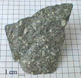
Igneous rocks are formed from solidification of molten material. Sedimentary rocks are formed by the accumulation of fragmental material derived from preexisting rocks of any origin as well as the accumulation of organic material or precipitated material. Metamorphic rocks occur as a result of high pressure, high temperature and the chemical activity of fluids changing the texture and (or) mineralogy of preexisting rocks.
Rock Colors
Perhaps the most apparent feature of rocks to the observer is the coloration. Although most rocks have a rather drab appearance, some have very distinctive and, in some cases, beautiful colors. Shades of red, green, gray and brown may be caused by iron-bearing minerals. Very light-colored rocks are generally lacking in iron-bearing minerals. The coloration of sedimentary rocks reflects the environmental conditions that existed during deposition.
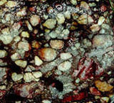
Purple and Red Rocks
Purple, maroon and red rocks are stained by the mineral hematite (iron oxide). Hematite results from the decomposition and oxidation of iron-rich minerals such as magnetite, ilmenite, biotite, hornblende and augite. A rock composed of only several percent hematite may be stained a deep red.
Green Rocks
Green sedimentary rocks are typically formed in a reducing environment where oxygen is not available. For sedimentary rocks, this would normally mean deposition in deeper water than red rocks. In a reducing environment, iron combines with silica compounds to form iron silicate minerals. Then lowgrade metamorphism will convert the iron silicates to the green mineral chlorite. Chlorite in sedimentary rocks indicates a deep-water depositional environment. Where chlorite-rich strata alternate with hematite-rich strata, a change in sea level probably occurred.
Black Rocks
Higher-grade metamorphism (high heat and pressure) will convert the hematite in red rocks and the chlorite in green rocks to the black minerals magnetite and biotite. An abundance of these minerals will yield a gray to dark gray mineral. Traces of black organic matter will also darken a rock to a gray or dark gray.
Weathered Surfaces
Many rocks have a different color on the weathered surface than on a fresh break. Weathering of disseminated pyrite (iron sulfide) in rocks will convert them to brown or yellow iron hydroxide and iron sulfate.
SEDIMENTARY ROCKS
Sedimentary rocks are derived from preexisting igneous, sedimentary and metamorphic rocks. These rocks contain many clues as to their origin and the conditions that existed while they formed. Sedimentary rocks make up 75 percent of the rocks at the earth's surface but only 5 percent of the outer 10 miles of the earth. Sediment, as distinguished from sedimentary rock, is a collective name for loose, solid particles and is generally derived from weathering and erosion of preexisting rock. After formation, sediments are transported by rivers, ocean waves, glaciers, wind or landslides to a basin and deposited. Lithification is the process of converting loose sediment into sedimentary rock and includes the process of cementation, compaction and crystallization.
Sedimentary rock is formed by lithification of sediments, precipitation from solution and consolidation of the remains of plants or animals. Coal is an example of sedimentary rock formed from the compression of plant remains.
Rounding of
Rock Particles
Rounding occurs during the transportation process by one or more of the erosional agents. Current and wave action in water are particularly effective in causing particles to hit and scrape against one another or a rock surface. The larger the particle the less distance it needs to travel to become rounded. For example, the boulders of the melon gravel deposited by the Bonneville flood were rounded after 3 to 6 miles of transportation.
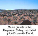
Deposition of Sediment
Sorting of sediment by size is also effectively accomplished by moving water. A river sorts sediment by first depositing cobbles, then pebbles, sand, silt and clay. The larger the size of sediment, the greater the river's energy necessary to transport it. Deposition is the term used to describe the settling of transported sediment.
Look at a diagram that
explains rounding and sorting.
Lithification of
Clastic Rock
Clastic or detrital sedimentary rock is composed of fragments of preexisting rock. The grains are generally rounded and sorted during the transportation process. Clastic sediment is generally lithified by cementation. Cementation occurs when material is chemically precipitated in the open spaces of the sediment so as to bind the grains together into a hard rock. Common cements include calcite, silica and iron oxides. A matrix of finer-grained sediments may also partly fill the pore space.
Common Types of Sedimentary Rock
Conglomerate is the coarsest-grained sedimentary rock formed by the cementation of gravel-sized sediments. The gravel is generally rounded; however, it probably did not travel very far. Conglomerates are generally deposited by a river.
Sandstone is a medium-grained sedimentary rock formed by the cementation of sand-sized sediments, with silt and clay forming the matrix. Sandstones may be deposited by rivers, wind, waves or ocean currents.
Shale is a fine-grained sedimentary rock composed of clay- and silt sized fragments. Shale's noted for its thin laminations parallel to the bedding. Compaction is very important in the lithification of shales. Before compaction, shale may consist of up to 80 percent water in the pore spaces.
Chemical Sedimentary Rocks are formed by material precipitated from solution. Examples include rock salt, gypsum and limestone.
Organic Sedimentary Rocks consist mostly of the remains of plants and animals. Coal is an organic rock formed from compressed plant remains.
Limestone is a sedimentary rock composed of mostly calcite. Some limestones are chemical precipitates, whereas others consist mostly of elastic grains of calcite or shells of marine invertebrates. The calcite grains in limestone recrystallize readily so as to form new and larger crystals.
Sedimentary Structures
Sedimentary Structures in sedimentary rock are formed either during the deposition process or shortly after deposition. One of the most important structures is bedding. An important principle of geology holds that sedimentary rocks are deposited in horizontal layers. The bedding plane is the nearly flat surface separating two beds of rock. Bedding planes originate by a change in grain size, a change in grain composition or a pause in deposition during the depositional process.
Mud Cracks are sedimentary structures that are abundant in many of the formations of the Belt Supergroup as well as in many Paleozoic marine sedimentary formations in Idaho. Mud cracks are polygonal cracks formed in clay- and silt-sized sediments. They are caused by the exposure of lake bottoms, river bottoms and tidal flats to the sun after being beneath water. The cracks are caused by the sun drying and shrinking the upper several inches of the exposed mud flat.
Ripple marks are small ridges, generally less than one inch high and 2 to 8 inches wide. The ridges are developed by moving water and form perpendicular to the direction of water movement. If the profiles of the ripple marks are symmetrical, they are caused by waves; if the profiles are asymmetrical, they are caused by currents. The steep sides occur in the down-current direction.
Sedimentary Rocks
of Idaho
Sedimentary rocks of Idaho were generally deposited in marine environments; however, a significant part are of continental origin. Most Precambrian and Paleozoic strata are marine; Mesozoic strata include both marine and continental deposits; all Cenozoic formations are continental. Marine deposits are noted for being thick and distributed over a large area. Most of the marine rocks in Idaho were deposited on the continental shelf and slope that slowly subsided over hundreds of millions of years. Even though a pile of sediments more than 50,000 feet thick may form, most of the material is deposited in shallow water such as in the intertidal zone.
IGNEOUS ROCKS
Magma
Igneous rocks are those rocks that have solidified from an original molten state. Temperatures within the earth are so hot that many rocks and minerals are able to exist in a molten condition called magma. This molten rock exists deep below the earth's surface in large pools called magma chambers. Many magmas or portions of magmas are lighter than the surrounding rock and tend to rise toward the surface of the crust; also, the high pressure at depth facilitates the upward movement of magma, Molten materials that extrude through the surface of the earth are called eruptive, extrusive or volcanic rocks. Those magmas that crystallize and solidify at depth, never reaching the earth's surface before consolidation, are called intrusives or plutonic rocks. Of course after consolidation, plutonic rocks may be exposed at the earth's surface by the process of erosion.
Look at Bowen's Reaction Series.
The crystal size of igneous rocks is very diagnostic of their origin. Volcanic or extrusive rocks have a very small average grain size which is generally too small to discern with the naked eye. Extrusive rock has a very high component of glass because it was quickly frozen from the molten stage before crystals had time to grow. The more deeply-buried plutons cool more slowly and develop a coarse texture composed of large crystals. Therefore, large mineral crystals of more than one inch in diameter indicate formation at a depth of 6 to 12 miles.
Look at chart of Mineral Proportions.
Mafic and Felsic Magmas
Magmas are thought to be generated in the outer 60 to 180 miles of the earth where temperatures are hot enough to cause melting. Magmas rich in magnesium, iron and calcium are called mafic. Those rich in sodium, potassium and silicon are called felsic. Those that are transitional between mafic and felsic are called intermediate. Felsic magmas are generated mostly within the continental crustal regions where the source of parent rocks are abundant- whereas, mafic magmas may be derived from parent materials rich in magnesium, iron and calcium which occur beneath the crust. Mafic magmas, coming from a deep hot source, are about 1,200 degrees centigrade when they reach the earth's surface; whereas, felsic magmas are much cooler - about 700 degrees centigrade upon reaching the earth's surface.
Origin of Basalt
Most basalt originates at spreading centers such as the mid-oceanic ridge system. Basalt magma originates from partial melting of mantle material. The fluid magma rises through fissures formed by tensional forces of two diverging plates.
Origin of Andesite
and Granite
Intermediate and felsic magma in Idaho are believed to have originated where a cool slab of oceanic lithosphere of basalt and overlying sedimentary rock descended beneath the continental crust of the western United States. The descending plate of lithosphere becomes hotter with increasing depth. Water trapped in the descending plate also lowers the melting temperature so that partial melting of basalt takes place. While the basaltic magma rises through the overriding continental crust, the magma absorbs some of the more silica rich rocks to become intermediate in composition. Also, the very hot basaltic magma chambers in the continental crust could melt the surrounding felsic rocks and create granitic magmas.
Emplacement of Magma
Bodies of intrusive rocks exist in almost every shape and size. Regardless of shape or size, they all come under the general term pluton. Most of them appear to be emplaced in the surrounding country rocks (host rocks) by the process of forceful injection. By forceful injection, the body is intruded along zones of weakness, such as fractures, by pushing apart the surrounding rock. A pluton is also emplaced by melting rock around it and prying out blocks of the country rock. The surface between the pluton and the country rock is the intrusive contact. Magma is also aided in its upward movement because it is generally less dense than the surrounding rock. When the magma stops moving it begins to crystallize. Those plutons that reach shallow to intermediate depths tend to be porphyritic, that is, large crystals are contained in a finer crystalline groundmass.
Types of Plutons
Dikes are small tabular plutons which cut across layering in the host rocks. Dikes may range from one inch to tens of feet thick. They are much longer than wide and can commonly be traced a mile or more. Dikes are generally intruded along fractures and tend to have the composition of pegmatite, aplite (white, sugar-textured dikes) and basalt. In almost every roadcut through the Idaho Batholith of central Idaho, aplitic and pegmatitic dikes can be seen.
Sills are also tabular bodies of the same approximate size and shape range as dikes. However, sills are concordant or parallel to the layers of the surrounding host or country rock. The Purcell sills are examples of such plutons in northern Idaho.
The largest plutons consist of granite and diorite and are found in the cores of mountain ranges. The Idaho Batholith is a good example. A batholith is defined as a pluton with a surface exposure in excess of 40 square miles. If the exposure is less than that, the pluton is called a stock. It is commonly believed that buried batholiths underlie large areas of widespread silicic volcanics in Idaho. Many of the large batholiths such as the Idaho Batholith are known to be a composite of many granitic plutons.
Pegmatites
Pegmatite bodies have a relatively larger grain size than the surrounding igneous rocks. Individual crystals are known to reach more than 30 feet in length. A pegmatite may have the composition of a granite, diorite or gabbro. All three types are exposed in the large granitic plutons of Idaho. However the granitic pegmatites are by far the most common. In practically every exposure of granitic rock in the state, there are one or more granitic pegmatite dikes exposed. Although most of these pegmatites do not exceed 10 feet in thickness; an uncommonly large pegmatite more than 300 feet along its smallest dimension is exposed in the City of Rocks near the town of Oakley.
The extremely large crystal size (generally 2 to 8 inches), is attributed to both slow cooling and low liquid viscosity. Pegmatites are the last portion of a pluton to crystallize. These residual fluids are much richer in certain elements than the original magma. High amounts of silica and ions of elements that are necessary to crystallize sodium plagioclase and potassium feldspar must be abundant in the fluids. The fluids are also rich in certain elements that could not be used in the crystal structure of the previously crystallized minerals. Water is also very abundant which promotes slower cooling and a lower temperature of crystallization. Many pegmatites were intruded along existing fractures.
Most Idaho pegmatites are composed of orthoclase feldspar, quartz and muscovite. Careful inspection will also reveal small red garnets, black tourmaline and bluish-green aquamarine. Aquamarine is generally only found in the tertiary plutons.
Common Igneous Rocks
Igneous rocks are classified on the basis of their texture and composition. Although more than several hundred names have been given to igneous rocks, only a few major divisions are discussed below.
Granite is the most common coarse-textured rock. It is formed at great depths within the earth and has crystals ranging from microscopic to more than one inch in size. Granite typically contains quartz, feldspar, mica and hornblende. Granites are generally light in color and may have a salt and pepper appearance. The feldspar may cause it to be white, gray, pink or yellowish brown. Most of the large bodies of plutonic rocks in Idaho have typical granitic texture and composition. Potassium feldspar and plagioclase feldspar make up most of the rock, though quartz may represent up to 25 percent of the bulk composition. The black minerals are commonly hornblende and biotite mica. Muscovite is also common in some granites.
Gabbro is a dark, coarse-grained igneous rock. It is generally composed of plagioclase feldspar and augite. Gabbro is generally dark green or dark gray in color. Idaho has relatively little gabbro compared to granite.
Pumice is lava that solidified while gases were released from it. It is essentially a frozen volcanic froth. Because of the abundance of gas cavities, pumice is so light in weight that it can float in water. Pumice is generally light gray or tan and has the same chemical composition as obsidian, rhyolite and granite.
Diorite is a coarse- to fine-grained plutonic rock and has a mineral composition that places it midway between granite and gabbro. It has little quartz or potassium feldspar. Diorite tends to be a gray rock due to the high amounts of plagioclase feldspar and iron-rich minerals.
Andesite is much finer grained than diorite but has the same mineral composition. Andesites are more common than rhyolites, but less common than basalts.
Rhyolite is a volcanic rock with the same composition as granite. The major difference is its fine-grain size or glassy texture. Rhyolite is generally light colored and may be gray, white, tan or various shades of red. It has a characteristic streaked texture called flow banding. Flow banding is caused by slow flowage of highly viscous lava.
Obsidian forms when magma of a rhyolitic composition cools so fast that crystallization of the minerals is not possible. Thus volcanic glass is essentially a frozen liquid. It is a lustrous, glassy black or reddish black rock. Obsidian has a conchoidal fracture giving it very sharp edges. Because of this property, it was commonly used to make tools and weapons by early man. One of the best-known obsidian flows occurs at Obsidian Cliffs in Yellowstone National Park.
Basalt is the fine-grained compositional equivalent of gabbro. It is by far the most abundant volcanic rock. For example, the volume of basalt in the Columbia Plateau is estimated to be 74,000 cubic miles. Basalt is normally coal black to dark gray when not weathered. Common constituent minerals include pyroxene, calcic plagioclase and olivine. Basalt commonly has small cavities called vesicles. Basalt flows are characterized by columnar Jointing which causes polygonal vertical columns that look like giant fence posts stacked on end. Most of the large basalt flows are extruded from large fissures in the earth's crust. Basalts are very common throughout Idaho, especially western and southern Idaho.
Look at an example of
Basalt of Portneuf Valley.
Look at an example of granodiorite.
Porphyritic Texture
Some fine-grained rocks such as basalt, rhyolite and, most commonly, andesite have a mixed texture of large and small grains. This texture is called porphyritic and is characterized by large crystals called phenocrysts surrounded by a groundmass (background) of smaller crystals.
Pyroclastic Rocks
In addition to the fluid lava extruded from a volcano, a great amount of lava is blown out the vent by violent gas explosions. All material driven out explosively is called pyroclastic. Large fragments such as spindle-shaped volcanic bombs fall near the vent. However, the dust-size fragments called ash can be carried hundreds of miles by prevailing winds. Volcanic ash is composed of fragments of volcanic glass and small crystals. When air-fall ash deposits consolidate, they are called ash-fall tuffs. Excellent examples of most of these volcanic products can be observed at Craters of the Moon National Monument.
One type of pyroclastic rock very common in southern and east-central Idaho is the welded ashflow tuff. This material consists of a very hot mixture of fragments of pumice, cinders, crystals and glass shards, many of which are more than one inch in size. They flow out of the vent and downslope somewhat like a lava flow, but riding on a cushion of hot gases. When the deposit settles and comes together, the angular fragments are so hot they weld together. Unlike rhyolite flows, a single ash flow tuff unit may extend up to 100 miles. These tuffs make distinctive rim formers above the lake-bed deposits in the Snake River Plain.
Volcanic Cones
Volcanoes are vents in the earth's crust through which molten rock and other volcanic products are extruded. There are three types of volcanic cones: cinder cones, shield volcanoes (lava domes), and composite cones (stratovolcanoes). All three types are common in southern Idaho.
Cinder cones are formed entirely of pyroclastic material, mostly of cinders. These cones consist of a succession of steeply-inclined layers of reddened scoriaceous cinders around a central crater. They are generally less than 1,000 feet in height and are susceptible to erosion because there is generally nothing holding the mass together. This type of cone has the steepest flanks of the three types of volcanic cones. Hundreds of cinder cones are distributed throughout the Snake River Plain, generally aligned along fractures in the crust. These cones disrupt the otherwise flat, featureless plain.
Shield volcanoes are built almost entirely of basaltic lava flows. They have gently-rounded profiles with a circular outline. This type of cone is the most stable and least susceptible to erosion.
Composite or stratovolcanoes are composed of alternating sheets of lava and pyroclastic material. these volcanic mountains are cone shaped and may be as much as 12,000 feet high. The alternating pyroclastic layers and lava layers indicate that the pyroclastic material was produced during periods of explosive activity, whereas the lava eruptions occurred at times of quiescence.
Caldera, are nearly circular basin-shaped depressions in the upper part of volcanoes. They are much larger than craters and are generally more than 6 miles in diameter. There are two types: explosive calderas and collapse or subsidence calderas. Most of those in Idaho are thought to have formed by collapse caused by the sudden withdrawal of supporting lava. Such calderas are common in southern and east-central Idaho.
METAMORPHIC ROCKS
Metamorphic rocks are those that have transformed from preexisting rock into texturally or mineralogically-distinct new rocks by high temperature, high pressure or chemically-active fluids. One or more of these agents may induce the textural or mineralogical changes. For example, minute clay minerals may change into coarse mica. Heat is probably the most important single agent of metamorphism. Metamorphism occurs within a temperature range of 100 to 800 degrees centigrade. Heat weakens bonds and accelerates the rate of chemical reactions. Two common sources of heat include friction from movement and intrusion of plutons. Pressure changes are caused primarily by the weight of overlying rock. Where there are more than 30,000 feet of overlying rock, pressures of more than 40,000 psi will cause rocks to flow as a plastic. Pressure may also be caused by plate collision and the forceful intrusion of plutons.
Chemically-active fluids (hot water solutions) associated with magma may react with surrounding rocks to cause chemical change. Directed pressure is pressure applied unequally on the surface of a body and may be applied by compression or shearing. Directed pressure changes the texture of a metamorphic rock by forcing the elongate and platy minerals to become parallel to each other. Foliation is the parallel alignment of textural and structural features of a rock. Mica is the most common mineral to be aligned by directed pressure.
Types of Metamorphism
There are two types of metamorphism: contact metamorphism and regional metamorphism. Contact metamorphism is the name given when country rock is intruded by a pluton (body of magma). Changes to the surrounding rocks occur as a result of penetration by the magmatic fluids and heat from the intrusion. Contact metamorphism may greatly alter the texture of the rock by forming new and larger crystals. In contact metamorphism, directed pressure is not involved so the metamorphosed rocks are not foliated.
Regional Metamorphism
Most metamorphic rocks are caused by regional metamorphism. This type of metamorphism is caused by high temperature and directed pressure. These rocks are typically formed in the cores of mountain ranges, but may be later exposed at the surface by erosion. Typical rock types include foliated rocks such as slates, phyllites, schists and gneisses.
Common
Metamorphic Rocks
Marble is a coarse-grained rock consisting of interlocking calcite crystals. Limestone recrystallizes during metamorphism into marble.
Quartzite forms by recrystallization of quartz-rich sandstone in response to heat and pressure. As the grains of quartz grow, the boundaries become tight and interlocking. All pore space is squeezed out; and when the rock is broken, it breaks across the grains. Quartzite is the most durable construction mineral. Although both marble and quartzite may be white to light gray, they may be readily distinguished because marble fizzes on contact with dilute hydrochloric acid, whereas quartzite does not. Also, marble can be scratched with a knife, whereas quartzite cannot.
Slate is a low-grade metamorphic equivalent of shale. It is a fine-grained rock that splits easily along flat, parallel planes. Shale, the parent rock, is composed of submicroscopic, platy clay minerals. These clay minerals are realigned by metamorphism so as to create a slaty cleavage. In slate, the individual minerals are too small to be visible with the naked eye.
Phyllite is formed by further increase in temperature and pressure on a slate. The mica grains increase slightly in size but are still microscopic. The planes of parting have surfaces lined with fine-grained mica that give the rock a silky sheen.
A schist is characterized by coarse-grained minerals with parallel alignment. These platy minerals, generally micas, are visible to the naked eve. A schist is a high-grade, metamorphic rock and may consist entirely of coarse, platy minerals.
A gneiss is a rock consisting of alternating bands of light and dark minerals. Generally the dark layers are composed of platy or elongate minerals such as biotite mica or amphibolite. The light layers typically consist of quartz and feldspar. A gneiss is formed under the highest temperatures and pressures which cause the minerals to segregate into layers. In fact, slightly higher temperatures than necessary to convert the rock into a gneiss would cause the rock to melt. If temperatures become sufficiently high, the rock begins to melt and magma is squeezed out into layers within the foliating planes of the solid rock. The resulting rock is called a migmatite - a mixed, igneous and metamorphic rock.
ORBICULAR ROCKS
Orbicular rocks are ellipsoidal-shaped masses of rock consisting of successive shells of dark minerals (biotite) and light minerals (feldspar). The occurrence of orbicular rocks is a rare phenomenon. There are fewer than 200 known localities throughout the earth. The State of Idaho happens to have at least three of these localities:
(1) one in the Buffalo Hump area in central Idaho
(2) one in southwest Idaho near Banks and
(3) one near Shoup in east-central Idaho. The orbicular rocks near Shoup crop out for about 2 km along the south side of the Salmon River.
Orbicular Rocks
Near Shoup, Idaho
The shape of the intrusion containing the orbicular rocks is very irregular. Along its periphery, numerous dikes of quartz diorite interfinger and discordantly penetrate the augen gneiss country rock.
Evidence in the field is persuasive for a dynamic emplacement of the intrusion. More than 50 percent of the total volume of the intrusion consists of angular xenoliths, xenocrysts and autoliths in a medium-grained, quartz diorite matrix. In other parts of the intrusion, the quartz diorite matrix represents up to 90 percent of the rock volume. Primary-flow foliation and schlieren tend to give the intrusion a gneissic appearance.
Breccia fragments are primarily xenoliths of augen gneiss, quartzite, biotite gneiss and biotite schist. Some of the xenoliths may have been transported a long distance because they are dissimilar to the enclosing rock types. The size range of the xenoliths is variable, with some blocks of augen gneiss almost 100 m in diameter.
The orbicules, which occur in clusters, were formed by the crystallization of alternate layers of plagioclase and biotite around the nucleus. However, in some cases nucleation occurs around xenocrysts and autoliths. Typically, the orbicules have a nucleus of coarse-grained biotite schist. These biotite schist xenoliths probably were brought up from deep in the crust because they are different from any rocks in the area. Although most xenoliths are mantled by at least one layer of plagioclase, many of the large angular xenoliths have several shells of biotite and plagioclase. The single plagioclase mantles are found on xenoliths of all rock types. Orbicules have up to 10 shells of plagioclase with each shell 3 mm to 1 cm thick (look at explanation).
The individual orbicules generally have a sharp contact with the surrounding matrix. For the most part, the external shape of the orbicules depends on the shape of the xenolithic nucleus. Shapes vary from spherical to ellipsoidal masses. Fragments of orbicule shells indicate that some orbicules may have been brittle at the time of emplacement; however, other orbicules were apparently deformed in a ductile condition as they were blasted against the host rock.
Idaho Soils
Soil Development
A small group of scientists in Russia developed a new concept revolutionizing soil science under the leadership of Dokuchaieva about a hundred years ago. They noted regular occurrences of vertically stratified, horizontal layers (horizons) in soil columns. The consortium concluded that a complete soil profile is the vertical section of horizontally layered, unconsolidated material down to the unaltered parent material. The horizontal layers develop naturally via a unique combination of soil-forming factors. The parent material is any material effected by its local environment while supporting plant life. Environmental factors include: 1) parent material, 2) climate, 3) topography, and 4) living organisms interacting dynamically through 5) time. Time is an important concept because soil profiles evolve, or mature, through time at rates dependent upon the other factors resulting in greatly varied characteristics and qualities of individual soil profiles worldwide. These genetic factors of soil formation are discussed separately.
Parent Material
Geological events over a great period of time have provided Idaho with many different kinds of parent material. Each kind has contributed different characteristics to soils, physically as well as chemically. In many cases, soils have developed in two or more kinds of material, one on top of the other or mixed together.
There are two general kinds of mineral parent materials - those that weathered in place from old rock formations (residuum) and those that were transported by wind, water, or ice.
There are many rock formations in Idaho. They include granite, gneiss, schist, limestone, and basalt. These rock formations are most easily seen in the mountainous parts of the state. Basalt occurs in large plateaus and plains in the northern part of the state and in the Snake River plain of the southern part. All of these rocks have undergone various degrees of weathering.
Parent materials moved by wind include sands and silts. Sands moved near the ground surface for relatively short distances. They appear mostly as dunes in rather small areas in southern Idaho along the Snake River and near Bonners Ferry in northern Idaho. Silt, with a small amount of very fine sand and clay, was carried longer distances. This is known as loess. Deposits of loess are extensive in northern Idaho, mostly on the Columbia River basalt plateaus, as well as large areas in the southern part of the state. In more moist areas some of the silts in the loess weathered to clay.
Volcanic ash of various ages, from recent times (a few hundred years ago) to quite old (at least 3 million years), was also carried by wind and deposited as an important parent material in various parts of the state. Volcanic ash contrasts with most parent materials in being lightweight.
Water has moved great quantities of material, in all parts of the state, providing a wide variety of, parent materials for soils. They grade from coarse materials, like sand, gravel, and cobblestones, where the water has moved fast to very fine materials, like silt and clay, where the water was still or moved slowly. These materials came from a wide variety of rock formations, which have influenced the physical and chemical properties of the soils.
Glaciers provided yet another kind of mineral parent material. Large glaciers advanced several times into-, Idaho from Canada as far south as Coeur d'Alene during the Pleistocene age. Small glaciers also occurred locally in the higher mountains throughout the state. The ice deposited a mixture of various sizes of rock along with finer materials.
Peat is a special kind of parent material that forms into organic soils. Organic soils mostly occur in bogs north of Coeur d'Alene and in parts of eastern Idaho. They may contain minor amounts of mineral material deposited by floods or wind.
These parent materials were subject to the other factors of soil formation - climate and living organisms modified by topography over a period of time. Actually, all the soil-forming factors are working at the same time with different rates of speed or efficiency. They constantly interact with one another.
Climate
Even a casual observer readily notes that there are many contrasting climates in Idaho. Precipitation ranges from about 8 inches per year with very little snow along the Snake River south of Boise, to over 60 inches with many feet of snowfall in the higher elevations of northern Idaho. Great changes of temperature and frost-free days per year also occur.
In some places, the climate changes within very short distances. This is especially true with an abrupt rise in elevation in the mountains. Also the climate of a steep north slope can differ markedly from a nearby steep south slope. This is most noticeable in the canyons along the Snake and Salmon Rivers where north-facing slopes are more moist and cooler than south-facing slopes.
What is it about climate that affects the formation and character of soils? There are direct as well as indirect effects. The amount of water that moves into and through a soil affects the rate at which weathering takes place. In the total absence of water, such as on the moon, this simply doesn't happen.
Water puts into solution many materials, such as compounds of potassium, sodium, calcium, magnesium, and silicon. The more water available, especially in a soil material that allows water to move easily, the more these compounds are removed from the soil. This can be seen in several of the soil profile pictures. Calcium carbonate is light colored. In soils having limited rainfall it has been moved by water from surface soil horizons into deeper layers. This is a common feature of many soils in the Snake River plain area and near Lewiston. With more annual precipitation, calcium carbonate is washed completely out of the soil.
Different chemical changes take place within soils influenced by the amount of water present and the soil temperature. With a state as varied as Idaho in precipitation and temperature, there are wide differences in soils. In general the drier parts of the state have higher ranges of soil reaction or pH. Most of these soils are neutral to strongly alkaline. In the more moist areas, pH values range from neutral to strongly acid. Availability of most plant nutrients is generally related to pH. Extremes of acidity or alkalinity adversely affect this availability.
Soils with an excess of moisture like those with fluctuating water tables are affected in yet another way. They are nearly always mottled with various shades of gray, brown, and yellow. Soils with mottles are saturated with water at some time of the year. Such soils in Idaho are usually in low-lying positions.
Water is also responsible for moving clay downward into lower soil horizons. Clay that has lodged in these horizons can be seen by using a hand lens. It appears as clay films, which resemble candle wax drippings. All the soil horizons having a lower case "t", such as Bt, have these clay films.
Chemical processes occur much more rapidly under high temperatures than under low temperatures. Alternate wetting and drying of soils can also affect chemical changes as well as physically mix soil materials, especially soils high in clay. In addition, freezing and thawing mixes soil materials.
Climate has an indirect effect on soil development. It influences to a large extent the kind and amount of vegetation.
Topography
Many geologic processes contributed to giving Idaho it’s many different landscapes. Topography, or lay of the land, is an important soil-forming factor. Hill-slope angles determine the thickness of soil profiles, which vary from hillcrest to hill-bottom; and the degrees of natural soil erosion alluvium deposition. If topography becomes too steep, then it may become unstable creating land or rockslides. Finally, topography affects soil formation by effecting local climate creating a microclimate, thus dynamically interacting with another variable.
Flat valley floors have slow to very slow runoff yielding moderately well to poorly drained soils. Little soil erosion takes place because the water does not move fast enough to pick up and transport sediment. In fact, the slow water velocities may cause sediment to fall out creating aggrading river segments. The valley floor also receives massive horizontally continuous layers of new parent material during periodic floods. These positions also have lower temperatures than adjacent uplands due to cold air drainage.
As the slope increases, there are progressive changes. Runoff is increased. Soil is lost by erosion rather than being accumulated. The soils become better drained. Air drainage is improved. All of these things are intensified with continued steepening of the slope. Soils on very steep slopes erode not only by water runoff, but also by soil actually creeping or rapidly sliding downslope. Larger fragments of gravel, cobblestones, and stones periodically roll down hill. Soils on very steep slopes commonly are either very shallow or contain a high percentage of rock fragments.
The direction in which slopes face in Idaho's latitude affects the local climate. This in turn affects soil development. Soils with south-facing slopes are significantly warmer and dry out faster than soils on nearby north-facing slopes. Strongly contrasting plant communities exist on north slopes compared to south slopes.
The particular shape and position of slopes also affects water runoff. Convex slopes contrast with concave slopes. Convex ridge positions disperse water more uniformly than do concave sloping areas which concentrate water causing greater runoff and erosion.
Living Organisms
Plants and animals, including man, affect the natural development of soils. Different kinds of vegetation incorporate varying amounts and kinds of residue into the soil. This residue of leaves, needles, stems, and roots are converted to organic matter by the many microorganisms present in the soil. The soil horizons most affected are near the surface where most of the residue occurs. Generally in the temperate climate of Idaho, dark colored soils have more organic matter than light colored soils.
There is a wide assortment of natural plant communities or habitat types, in Idaho. In the driest and warmest part south of Boise, the vegetation is relatively sparse. The natural level of organic matter is low - well below 1 percent. The soils are light colored. With a rise in precipitation and decrease in temperature, the vegetation becomes more abundant, and the organic matter in the soils increases. This reaches the highest level under dense grasses that once covered the prairie near Grangeville. Organic matter in the black soils of this area was nearly 10 percent.
With further increases in precipitation and cooler temperatures, coniferous forests begin. There are fewer grasses and forbs under the trees, which provide a low amount of organic material. Soils are more strongly leached; lighter colored, and contain less organic matter. At higher elevations, however, the surface soil horizons are darker colored and are high in organic matter. Colder temperatures at these elevations retard the decomposition of organic matter.
Microorganisms are present in all soils in varying amounts. When organic residue from plants and animals is provided, their numbers rise spectacularly. These tiny organisms are largely responsible for the decomposition of organic material.
Larger organisms are also present such as insects, worms, rodents, and other burrowing animals. They contribute to the decomposition of organic material as well as generally mix the soil.
Man has contributed to the present nature of soils in dramatic ways. Clearing the forests for cultivation has permanently changed the natural soil temperature and the rate of water runoff.
Breaking out the natural prairies and clearing the forests for cultivation has mixed the surface soil and has in many places allowed great quantities of soil to be eroded. Soils are no longer as deep and the surface soils are lower in organic matter and have poor tilth.
Many soils in the Snake River plain of southern Idaho have been leveled for more efficient surface irrigation. Some soils have been cut (soil removed) while others have been filled (soil deposited).
Time
Last, but equally important, is the effect of time on the formation of soils. Time is required for all things to happen. Time is merely relative, however, when understanding its effect on soil development. It is not just the number of years that has passed but the intensity of the soil forming processes during a given period of time that determines soil development. For example, a parent material available for soil development in a dry cold climate with sparse vegetation would develop exceedingly slow. In fact, not much would ever happen. The same kind of parent material in a warm moist climate with abundant vegetation would develop at a much faster rate.
The question which is often asked about how long does it take to make an inch of topsoil has many answers. The minimum time required is believed to be many hundreds of years.
Development of a soil generally reflects its age. A soil is considered to be "young" if its soil horizons are weakly expressed. The soil may have some accumulation of organic matter in the surface layer and only very weak development of a B-horizon or none at all. A soil is "old" if its soil horizons are well developed. An example of an "old" or older soil would be one showing evidence of clay movement from a surface horizon into the subsoil.
It is easy to understand why there are so many different soils in Idaho, even within each county. There are seemingly an endless variety of significantly different combinations of the five soil forming factors. It is the combined effects of a particular set of these genetic factors that result in a "soil".
Idaho Soils & Economics
Every living thing on earth depends on six inches of topsoil. Destruction of this easily damaged resource can turn lush farmland into desert. We can look around the world and see examples of this. The lack of rain south of the Sahara Desert in Africa is causing the desert to edge farther south by more than one foot per year. This may not seem like much but the desert stretches for thousands of miles. This means many square miles of farmland become useless each year.
We look at the Sahara and think, "Well, that is far away." Sometimes it happens closer to us. In the 1930s the land in the Great Plains of the United States was overfarmed. Then a drought, or lack of rainfall, occurred. Because of the lack of rainfall and intense farming, the winds blew the topsoil away. The area became known as the "dust bowl." More than 50 years later, the land in the dust bowl has not fully recovered.
Soil in Idaho is sometimes lost in other ways. One way is erosion. This is when the water or sand wears away the topsoil. Sometimes humans erode the soil. Open mining of phosphates could cause soil erosion. The top layers of soil are scraped off exposing the phosphate. Lumber companies in some areas of the nation at one time cut so many trees that the topsoil was exposed to rushing water. This eroded the soil.
Today, measures are taken to protect the topsoil. Phosphate mining companies save the topsoil and replace it after the phosphate is mined. Lumber companies now plant more trees than are cut.
This helps protect the soil, which is the basis for Idaho's largest industry, agriculture or farming. The soil is where the plants that provide us with food, fiber and shelter grow.
Idaho has several types of soil. They can be grouped into seven major types based on features of the soil, the natural vegetation, the type of land where they are found and for what they can be used.
Much of the area of the Snake River Plain is covered with a naturally dry, limy soil. This is found in a very thin layer less than six inches thick. It is made up of a mixture of wind-blown soil and volcanic ash. Most of the 3.5 million acres of irrigated land in Idaho is of this type and more than half of the field crops produced in Idaho are from this soil. The ash from volcanic explosions over millions of years has mixed with the soil to produce a soil well-suited for the growth of crops such as potatoes, wheat, corn, barley, sugar beets and alfalfa.
Along the edges of this area is another type of soil that is similar. This soil is a darker soil and contains soil deposited by water and other types of minerals as well as the wind-blown and volcanic materials. Another deeper soil, with more clay, is also found along the edges of the plain where there is more rainfall. Many crops can be grown in this area without irrigation.
Some of the mountain valleys contain a dark, naturally moist soil that was formed by the action of glaciers breaking up rocks as well as by dirt deposited by flowing water. The deeper areas of this soil are used to grow grains and hay and the more shallow soil is used for the grazing of livestock.
In the forested areas of the state the soil is made up mostly of decaying plant matter mixed with a variety of rocks. This soil, while suitable for growing trees, is much too thin for the growth of many other types of crops. Even in the mountain valleys where farming takes place, the main crops are alfalfa for feed and grains such as wheat and barley. Care must be taken by lumber companies to protect the soil after cutting trees so new forest growth can take place. In the higher areas a similar soil is found. It is mixed with rocks and matted with roots of grasses and shrubs that grow above timberline.
One other type of soil in Idaho is a dark-colored very wet soil found in some river basins. When drained, this soil will grow almost any crop that weather will allow. Undrained areas are used for pasture for livestock or waterfowl wildlife areas.
Caves in Idaho
Corrosion Caves
Corrosion caves are formed by erosive action of water, waves or currents on a relatively soft rock. These caves generally occur at the edge of a river or lake.
Corrosion caves are generally shallow and not as impressive as lava caves or solution caves. Archeologists, however, have found that early man commonly camped in small corrosion caves while hunting or fishing in the vicinity of water bodies.
Rock shelters are also formed by erosion recessing the lower rocks in a cliff and leaving an overhanging rock shelter. Many of these rock shelters have yielded valuable information on the culture and migration patterns of early man in Idaho.
Solution Caves
Solution caves are formed by slightly acidic ground water circulating through fractures in limestone. This water is capable of dissolving great quantities of solid rock. As time passes, the openings become larger and larger until they may be large enough for a man to pass through.
Cone-shaped forms called stalactites are deposited by underground water. Stalactites are composed of calcium carbonate and look like icicles hanging from cave roofs. Stalagmites are similar in composition and origin to stalactites but are formed from ground water dripping on the cave floor. The best examples of solution caves are found in the Paleozoic carbonate rocks in eastern Idaho.
Lava Caves
Lava caves, also known as lava tubes, form in the central portion of a lava flow. Immediately after the flow is extruded, the outer margins of the flow cool and freeze in place, including the bottom, sides and top. Although the outer margin of the flow has solidified into basaltic rock, the central core is still molten and continues to flow towards the flow front. When the source of lava is cut off, the lava flows out the end of the tube and leaves a cave. These caves are typically 10 to 20 feet in diameter. They are characterized by both stalactites and stalagmites formed by lava dripping off the roof of the tube. Basalt flows on the Snake River Plain have many excellent examples of these caves. Many such caves are found where a thin portion of the roof collapses and leaves a precarious entrance to the cave.
Glaciation in Idaho
A glacier is a large, slow-moving mass of land ice that moves under its own weight. It is formed by the accumulation, compaction and recrystallization of snow. For a glacier to form, more snow must accumulate than is melted. Two types of glaciation are recognized and both have affected Idaho. Alpine glaciation of smaller aerial extent is found in mountainous regions; whereas continental glaciation has covered a large part of the continent with a huge ice sheet. Both types of glaciation have dramatically changed the landscape.
Great Ice Age
The Great Ice Age was a period of recurring glaciations that affected northern Idaho. This ice age began about a million years ago and marked the beginning of a long period of colder climate. Mountain glaciers formed in all the high country. These glaciers were so extensive that almost a third of the present land surface of the earth was covered with ice. About 20,000 years ago the last great ice sheet retreated from the northern United States. During the later stages it went through a succession of retreats and minor advances. The part of the ice sheet that affected northern Idaho lingered in Canada until about 6,000 years ago when it finally melted. Evidence of this ice age is now widespread throughout the high country of Idaho. Traces of glacial erosion and deposition can be found in most of the mountainous areas.
Glacial Erosion
Slow-moving glaciers plowed up soil and loose rock and plucked and gouged boulders from outcrops. This material, caught in the glacier, was used as an abrasive to grind down, polish and scratch the exposed outcrops in its downward path. In this way glaciers soften landscapes by wearing down hilltops and filling in valleys. In mountainous areas, glaciers confined to valleys (valley glaciers) scooped out and widened the valleys leaving a U-shaped cross profile. Stream erosion normally leaves a V-shaped valley so that the presence of a U-shaped valley is strong evidence that the valley was shaped by a glacier.
A glacial cirque is a steep-sided, rounded, bowl-shaped feature carved into a mountain at the head of a glacial valley. In the cirque, snow accumulates and eventually converts to glacier ice before heading down the glacial valley. A horn is the sharp peak that remains after cirques have cut back into a mountain on several sides Sharp ridges called aretes separate adjacent glacially-carved valleys. The Sawtooth Mountains of Idaho offer exceptional examples of glacial erosional features such as U-shaped valleys, cirques, horns and aretes as well as smaller features such as polished and striated bedrock.
Glacial Deposition
As glaciers move down valley, rock fragments are scraped and plucked from the underlying bedrock and the canyon walls. Most of these rock fragments are angular. When the material picked up and transported by the glacier is deposited, it is called till. Glacial till consists of unsorted fragments ranging from clay size to boulder size, all mixed together with no layering. Glaciers can easily carry any size rock fragment including boulders as large as a house. An erratic is a huge, ice-transported boulder that is not related to bedrock in the vicinity.
A moraine is a body of till deposited by a glacier. Ridge-like piles of ice left at the sides of a glacier are called lateral moraines. Medial moraines are developed where two glaciers come together and their lateral moraines merge and continue downglacier as a single long ridge of till. An end moraine is piled up along the front edge of ice at the downslope terminus of a glacier. Valley glaciers tend to leave an end moraine with the shape of a crescent ridge.
There are two types of end moraines: a terminal moraine is an end moraine marking the farthest advance of a glacier- a recessional moraine is an end moraine developed while the terminus of a receding glacier is temporarily stationary. Redfish Lake near Stanley is a glacial lake. The lake occupies a U-shaped, glacially-carved valley and the water is contained on the sides by lateral moraines and on the north end near the lodge by a terminal moraine.
As the ice of a glacier melts, ground moraine is deposited at its base. This blanket of till extends over larger areas that were covered by an ice sheet.
Oval-shaped hills consisting of thick ground moraine deposits are called drumlins. Drumlins have their long axis parallel to the direction of ice movement.
Streams that drain glaciers are heavily loaded with sediment, especially during the summer months. These outwash streams form a braided pattern and their deposits are layered as are all stream deposits. Thus, outwash deposits can be distinguished from till which is unsorted.
Eskers are long, sinuous ridges of water-deposited material up to 30 feet in height. They are deposited in tunnels either within or under glaciers where the meltwater loaded with sediment flows under and out of the ice.
Large blocks of ice are commonly buried within the thick deposits of outwash in front of a retreating glacier. When the ice block melts, a depression called a kettle is formed. These depressions may be later filled with water and become permanent lakes.
Pleistocene Ice
Age in Idaho
Glaciation began in the northern hemisphere more than two million years ago. Ice sheets that formed in southern British Columbia probably moved southward following south-trending valleys repeatedly between 2.5 m.y. ago and 100,000 years ago. However, the two most recent events occured in the last 100,000 years. These recent events left most of the physical evidence we see today.
The topography of Central and northern Idaho are a result of both continental ice sheets and mountain glaciers. Evidence of Pleistocene glaciation can be seen in mountainous areas at elevations as low as 5,000 feet above sea level.
In northern Idaho, the continental ice sheet moved from the Canadian ice fields towards the south into northern Idaho. This ice sheet probably extended no further south than the north end of Coeur d'Alene Lake. As climatic changes affected the sources of ice in the Canadian ice fields, the ice sheet may have receded and again moved north through several episodes. The continental ice sheet, originating in the Canadian ice fields, invaded northern Idaho repeatedly. Slow advances were followed by retreat as the climate warmed or cooled. During the melting phases, deposits of sand and gravel accumulated at the margins of the ice lobe. These deposits are commonly called recessional moraines. The grinding of the moving ice sheet left scratched, grooved and polished surfaces on much of the bedrock in northern Idaho.
During maximum glaciation, the ice was thick enough to pass over the highest peaks of the Selkirk and Cabinent Ranges at elevations of more than 6,000 feet. This required an ice sheet to be more than 4,500 feet thick in the vicinity of Sandpoint. The ice may have been more than 2,000 feet thick at the southern end of Lake Pend Oreille during maximum glaciation.
Alpine Glaciation
in Idaho
From 7,000 to 25,000 years ago, alpine glaciation was widespread in the higher elevations of the state. At least two periods of major glaciation are evident in Idaho. The last stage of alpine glaciation occurred about 4,000 years ago. This glacial action was relatively minor as glaciers existed only in the highest mountains of the State.
Glacial Lakes
and Floods
Large quantities of glacial meltwater had a dramatic effect on the landscape. Much rock debris was transported by water and deposited in valleys. Many floods were caused by glacial ice impounding water and then bursting. Huge catastrophic floods were caused in such a manner and drastically eroded the landscape.
During and immediately following the ice age, the streams of Idaho carried much more water than they do now. Larger streams and rivers could transport a much greater sediment load, mostly of glacial debris. At this time, the abundance of water caused large lakes to form in closed basins. One of the largest of these lakes was ancient Lake Bonneville, once covering more than 20,000 square miles with a maximum depth of more than 1,000 feet. The Great Salt Lake is a remnant of this lake. Lake Bonneville rose until the water broke through Red Rock Pass in southeastern Idaho. This huge flood swept over the pass, down the Portneuf River to the Snake River. The flood waters roared across the Snake River Plain, and for the most part, followed the Snake River into Oregon.
(The remarkable depositonal and erosional features caused by this flood are discussed in the Lake Bonneville Flood module.)
Ancient glacial Lake Missoula was created by an ice lobe forming a dam near the Idaho-Montana border. By melting or erosion this dam was suddenly removed and great floods were released throughout the northwest. Glacial debris left by the retreat of the great glaciers dammed streams and formed many modern lakes in Northern Idaho, including Hayden, Spirit and Twin Lakes. Pend Oreille Lake was formed in a similar fashion by glaciers eroding the lake basin and glacial debris damming the south end.
Floods from glacial Lake Missoula passed through the northern part of Pend Oreille Lake. Ice dams forming glacial Lake Missoula failed many times causing floods to move across northern Idaho. These catastrophic floods flowed south and southwest scouring great channels in the Columbia Plateau in the eastern and central parts of the State of Washington. This area is commonly called the channeled scablands. Three terraces along the Clark Fork and Pend Oreille River valleys were formed by the three floods from glacial Lake Missoula.