
Archaeology
Archaeology Defined
Archaeology Defined: Goals and Frameworks
Archaeology is simply the study of the material things of the past.There is over a century of jargon that can and will be applied, but in very simplest terms, archaeologists study stuff that is preserved so that we may decipher something of the culture, beliefs, and values of past societies. Archaeology is ANTHROPOLOGY, not really a subdiscipline, but perhaps a body of methods and teachniques that are applied to the analysis of MATERIAL CULTURE (cf. Gardin and Peebles 1992; Leone and Potter 1988; Malina and Vasicek 1990; Renfrew and Zubrow 1994; Tilley 1990). Material culture is that whole domain of things made and used by people. Material culture studies embody analyses of technology, design, function, social organization, history, religion, ritual and belief. People use things to encode and inculcate behavior, to express values and feelings, as well as to extract energy and meet nutritional requirements. Archaeologists expect to be able to find out a great deal about past societies through careful systematic analyses of the objects those societies created. The record of the past is most often incomplete. Many objects are perishable, and they simply are not preserved in archaeological sites. Patterns in artifacts are found, however, and this patterning preserves much of the original context of use and meaning that surrounded the creation and use of every object.
Archaeology's history is a checkered one (Trigger 1989; Willey and Sabloff 1993). The first archaeologists were avocational explorers, diggers, and speculators. Some were fascinated by holding bits of the past. Others were driven by the desire to make money off of exotic treasures. This was the era of Indian Jones. Archaeologists were active fieldworkers, certainly better than theorizing anthropologists permanently glued to armchairs in upper class Victorian sitting rooms, but they were destructive collectors who intended to amass neat objects for display in museums.
By the middle 1900s, archaeologists began to try to preserve more information about the things they found. Elaborate strategies were designed for classification of things. Complete descriptions were the goal, and archaeology became more and more systematic, as well as more and more scientific in view and approach. This was the rise of the CULTURE-HISTORICAL SCHOOL of archaeology in the United States. Things were carefully excavated to standards of stratigraphic recording and reports emphasized the location and dating of things. Digs, often facilitated through Works Projects of America funding, were massive in scale. Entire sites were excavated and collections of things numbered in the hundreds of thousands.
Construction of local and regional chronologies was the goal, and distributions of objects in SPACE and TIME were held indicative of past societies and the movements of cultures and cultural ideas across the landscape (cf. Willey and Phillips 1958). Cultural TRAITS were defined that had demonstrated importance in defining the stringers of time and space, and these became the major rubrics for analysis and discussion of archaeological CULTURES. Emphasis was on description, CLASSIFICATION, and construction of narratives that explained the ARCHAEOLOGICAL RECORD in terms of alleged cultures that moved through space of time. Changes in traits became axiomatically associated with changes in basic elements of socioeconomic organization and earmarks of changing adaptive systems as well as labels for specific ethnic and linguistic groups in the past.
WHAM - BAM! CAME THE 60s! Old traditional culture history was bashed, mashed, chewed, and abused by the NEW ARCHAEOLOGISTS. These Mad Dog-, hell-bent-for-science PROCESSUALISTS would truck no more lengthy descriptions of stuff and tedious typological constructions (Binford 1962, 1964, 1965, 1968; Leone 1972; Watson et al. 1971). Their rallying cry was that there must be more to archaeology than a slavish adherence to the old kulturkreise school. Processualists would emphasize use of basic scientific method, with reliance on explicit HYPOTHESIS TESTING and characterization of human societies as ADAPTIVE SYSTEMS (e.g., Binford and Sabloff 1982; Clarke 1977; Flannery 1967, 1968, 1982; Hodder 1978). Culture-historical reconstructions were declared to be pseudo explanatory frameworks and definition of traits though useful for placing past societies in the basic framework of time and space could not be the declared end-products of archaeological research. CULTURAL CHRONOLOGIES were simply the beginning, serving as useful classificatory frameworks, in which more compelling questions of adaptation and CULTURAL CHANGE could be MODELED and addressed (cf. Clarke 1978; Sabloff 1981). The archaeological record was seen as archaeology's laboratory for studying HUMAN BEHAVIOR over the long expanse of time. Processual archaeology was firmly based in CULTURAL MATERIALISM in the mode of Leslie White and Marvin Harris, and asserted that the only suitable approach was to focus on the relationships between society and the physical environment. TECHNOLOGY was the principal means of human adaptation. SOCIAL ORGANIZATION facilitated the extraction of resources through use of technology. IDEOLOGY simply justified what had to be done to accomodate production (Harris 1968, 1979; White 1959, 1969, 1975). This view holds that cultures are inherently or overwhelmingly rational: CULTURE is defined as man's extrasomatic means of adaptation to his environment. Proponents asserted that archaeology was uniquely suited to establish patterns in how humans chose to adapt to their physical environments, and that archaeologists would contribute to knowledge of human behavior by identifying UNIVERSALS that would address behavior in terms of past-present-future.
In the early '80s a group of pragmatic archaeologists, leery of dooming culture-historical reconstructions to the trash heap and appalled by POSITIVIST materialist dogmas, advocated a HOLISTIC inspection of all facets of culture (technology, social organization, ideology) by archaeologists. These anthropologists were tagged as POST-PROCESSUALISTS (e.g., Hodder 1982, 1986, 1993; Shanks and Tilley 1987; Tilley 1990). This label actually encompasses a wide range of anthropological approaches that are grouped only when considered in contrast to the more narrowly defined materialist approach of the processualists. Post-Processualists emphasize study of patterns in material culture and insist that archaeologists can extract meaningful inferences about values, beliefs, religion, and social structure, as well as the more obvious socioeconomic or technological elements of human adaptation.
Archaeology for Post-Processualists is often defined as the anthropology of material culture, and encompasses but is not limited to Materialist positivistic approaches to study of past societies. Key words for Post-Processual approaches include material culture study, with key concepts being CONTEXT and CRITICAL THEORY. As the anthropology of things, Post-Processualist theory draws upon a vast array of anthropological theories, including Structuralism, Symbolic Anthropology, and tenets of Critical Marxism. Archaeology emerges in its P-P guise as a social anthropology of the past, not purely Western Science and not purely History, but a holistic study of humans in the past, including their institutions, their beliefs, and their culture in all its many facets.
Post-Processual approaches build on Culture History and on the New Archaeology of the Processualist school, but seek to broaden the field of study dramatically. P-p archaeologists are anthropologists who study material culture (Past-Present-Future). Under this definition, archaeologists no longer have to excavate sites. They might explore dumps, analyze gravestones, perform surveys of extant architecture, or canvas wearing apparel in shopping malls. P-P types dig though, and the analytical framework presented here addresses the tenets of the old school and applies method of the new.
Terms and Concepts
Archaeology as a discipline predicated on the analysis of a complex subject, has evolved a jargon or lexicon all its own. In these cartoons, reproduced from Malina and Vasicek (1990:Figs.3,4), the archaeologist attempts to sort out all the myriad jargon terms that have become shorthand referents to theories and concepts. All deal with what the archaeologist finds, and how the archaeologist constructs inferences.
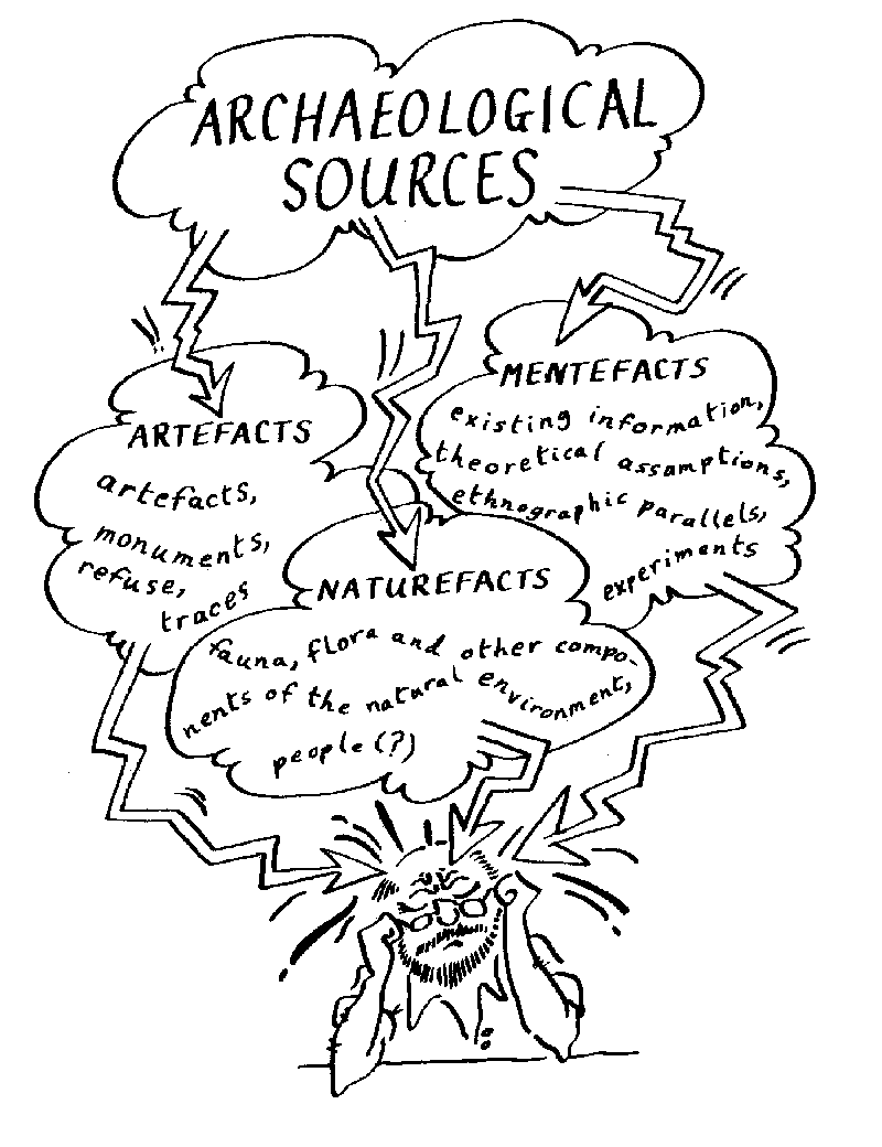  |
| Figure 1. Cartoons showing the jargonized process of description and classification: a task not for the meek (from Malina and Vasicek 1990: Figs. 3 and 4). |
ARTIFACTS are things made, used, and modified by people. The term refers to tools, residues of tool manufacture, residues of processing plants and animals, and by-products of tool manufacture, processing, or other human activities.
NATUREFACTS are parts of plants or animals not modified by man, but indicative of man's physical environment. For example, seeds, plant parts or small animal remains found in an archaeological site can be analyzed to determine season of the year for man's occupation or indicate the climate and environment of a given period.
MENTEFACTS are the ideas and values that govern the creation of artifacts. Also called "mental templates" or "cognitive maps" or "cognitive frameworks," these structures are not beyond archaeological inference. Recognition of Mentefacts allows archaeologists to explore nonmaterial aspects of culture through analysis of the material manifestations of cultural needs and beliefs.
How Do We Get To Inference from Things?
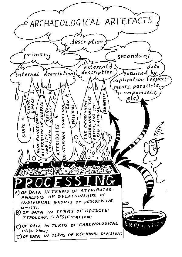
These cartoons depict the inner recesses of the researcher's mind: things found, categories applied, inferences drawn, facts elicited. Artifact applies to the totality of the object or thing found. To find patterns indicative of human behavior, and hence, culture, we must have a finer level of measurement: the ATTRIBUTE. Attributes are measurements or observations drawn or about artifacts. The attribute measured may be one zone of wear on a formed tool. So, a given tool form may have dozens of measurable attributes. No description is adequate without measurements taken at the attribute level of analysis. Attributes may record basic morphology, alterations of surfaces, signposts of manufacture, indicators of depositional environment, quantities or requencies, and any number of other variable dimensions. Malina and Vasicek (1990), Neustupny (1993) and Shennan (1988) offer excellent discussions of the need for rigorous measurement frameworks in archaeological research (see also Clarke 1968, 1972 and 1977).
Inferences about past human behavior are constructed by correlating and cross-tabulating attribute lists. Our inferential patterns are then arranged in shifting hierarchies, with one form or focus simply being the level of measurement at which the pattern analysis is performed:
Gross: distribution of artifact types within the site.
Moderate: patterns of selected features observed on artifacts.
Fine: patterns defined by careful correlations of descriptive dimensions outlining attribute characteristics across tool types.
Very Fine: microscopic examination of working edges and working surfaces and physical and chemical examination of surfaces and residues, which result in pattern analysis performed on parts of a single artifact. Here, the artifact becomes directly analogous to the archaeological site.
References Cited
Binford, L.R. 1962 Archaeology as anthropology. American Antiquity 28(2):217-225.
Binford, L.R. 1964 A consideration of archaeological research design. American Antiquity 29(4):425-451.
Binford, L.R. 1965 Archaeological systematics and the study of cultural process. American Antiquity 31(2):203-210.
Binford, L.R. 1968 Some comments on historical versus processual archaeology. Southwestern Journal of Anthropology 24(3):267-275.
Binford, L.R. and J.A. Sabloff 1982 Paradigms, systematics and archaeology. The Journal of Anthropological Research 38:137-153.
Clarke, D.L. 1968 Analytical Archaeology. London: Methuen.
Clarke, D.L. 1972 Models in Archaeology. ed. London: Methuen.
Clarke, D.L. 1977 Spatial Archaeology. London: Academic Press.
Flannery, K.V. 1967 Culture history vs. cultural process: A debate in American archaeology. Scientific American 217:119-122.
Flannery, K.V. 1968 Archaeological systems theory and early Mesoamerica. In Anthropological archaeology in the Americas, B.J. Meggers (ed.), pp.67-87. Washington, D.C.
Flannery, K.V. 1982 The Golden Marshalltown: A parable for the archaeology of the 1980s. American Anthropologist 84:265-278.
Gardin, J.-C. and C.S. Peebles (eds.) 1992 Representations in archaeology. Bloomington: Indiana University Press.
Harris, M. 1968 The rise of anthropological theory. New York: Crowell.
Harris, M. 1979 Cultural Materialism: The struggle for a science of culture. New York: Random House.
Hodder, I. 1978 Simulation studies in archaeology. ed. Cambridge: Cambridge University Press.
Hodder, I. 1982 Theoretical archaeology: A reactionary view. In Symbolic and structural anthropology, I. Hodder (ed.), pp.1-16. Cambridge: Cambridge University Press.
Hodder, I. 1986 Reading the past: Current approaches to interpretation in archaeology. Cambridge: Cambridge University Press.
Hodder, I. 1993 The narrative and rhetoric of material culture sequences. World Archaeology 25:268-282.
Leone, M.P. (ed.) 1971 Contemporary archaeology. Carbondale: Southern Illinois University Press.
Leone, M.P. and P.B. Potter (eds.) 1988 The recovery of meaning: Historical archaeology in the eastern United States. Washington, D.C.: Smithsonian Institution Press.
Malina, J. and Z. Vasicek 1990 Archaeology yesterday & today. Cambridge: Cambridge University Press.
Neustupny, E. 1993 Archaeological method. Cambridge: Cambridge University Press.
Renfrew, C. and E.B. Zubrow (eds.) 1994 The ancient mind: Elements of cognitive archaeology. Cambridge: Cambridge University Press.
Sabloff, J.A. (ed.) 1981 Simulations in archaeology. Albuquerque: University of New Mexico Press.
Shanks, M. and C. Tilley 1987 Reconstructing archaeology. Cambridge: Cambridge University Press.
Shennan, S. 1988 Quantifying archaeology. Edinburgh: Edinburgh University Press.
Tilley, C. (ed.) 1989 A history of archaeological thought. Cambridge: Cambridge University Press.
Tilley, C. (Ed.) 1990 Reading material culture. Cambridge: Cambridge University Press.
Watson, P.J., S.A. LeBlanc and C.L. Redman 1971 Explanation in archaeology, an explicitly scientific approach. New York: Columbia University Press.
White, L.A. 1949 The science of culture: A study of man and civilization. New York: Farrar and Strauss.
White, L.A. 1959 The evolution of culture. New York: McGraw-Hill.
White, L.A. 1975 The concept of cultural systems: A key to understanding tribes and nations. New York: Columbia University Press.
Willey, G.R. and P. Phillips 1958 Method and theory in American archaeology. Chicago The University of Chicago Press.
Willey, G.R. and J.A. Sabloff 1993 A history of American archaeology. New York: W.H. Freeman and Company.
Feature System (FS) recording procedures are designed to provide an efficient standardized system for accurately defining archaeological site context, association and provenience. Recording forms are coupled with computerized relational data base managers to facilitate research and report production.
Terms and Concepts
Terms and concepts integral to archaeological excavation recording systems include:
ARTIFACT.
An artifact is any portable object made or modified by human activities.
ASSOCIATION.
An association is any defined relationship between artifacts or features. An association must be defined. An association is not something that is found.
CONTEXT.
Context may be found or it may be defined. Context may also be primary or secondary.
-FOUND CONTEXT.
- This label is dependent upon recognition of a bounded cultural features, and this in turn is dependent upon recovery of artifacts IN SITU.
-DEFINED CONEXT.
- This label requires that the extent of diffuse or unbounded cultural be defined, subjectively or objectively.
-PRIMARY CONTEXT.
- This pattern is the direct result of specific human activities at a particular site, on a specific surface, over a short span of time.
-SECONDARY CONEXT.
- This pattern is only indirectly a result of the original human activity, and may in fact be due to considerable cultural or natural disturbance after having been laid down in the archaeological site.
DATUM.
This is the designated point on a site from which all vertical and horizontal measurements or provenience are taken. Datums may be
-PRIMARY.
- The initial or principal point from which all vertical and horizontal measurements of provenience are taken.
-SCONDARY.
- A second datum set up to facilitate taking of vertical and horizontal measurements. This datum is created for convenience, usually because of significant changes of slope on the site surface.
FEATURE.
A feature is literally anything you feel is pertinent to note or to refer to in your observations. Features seem to indicate connection or association between phenomena observed in the archaeological record. Feature may be cultural or noncultural, and may be bounded or diffuse.
-CULTURAL.
- Cultural features have residue of human activity, produced either intentionally or unintentionally.
-NONCULTURAL.
- Noncultural phenomena that cannot be attributed directly nor indirectly to human activity.
-BOUNDED.
- This is a cultural feature with easily defined extent (e.g., a firepit or a living floor).
-UNBOUNDED.
- A cultural feature that cannot be clearly defined by the observor (e.g., increasing and decreasing densities of artifacts or diffuse lensing of noncultural depositional layers).
FIELD SPECIMEN NUMBER (FS).
The Field Specimen Number of "FS" is the single most important provenience distinction in the recording system after recognition of the feature designation. This number is unique to Feature and excavation level. Artifacts, ecofacts and naturefacts removed from each excavation level are placed in separate excavation bags that are given distinct field specimen numbers. Each artifact will be given a distinct suffix within the field specimen number assigned to the excavation level or feature bag. Complete labeling for an FS bag is shown below:
FS 165 - 16
145N 116E
LEVEL 45-50 cm
F24/13
6/19/92
BDS
FS= Field Specimen
165= sequentially given field specimen number
-16= unique designation for an artifact from the FS165 field specimen lot
145N= SW unit corner on N line at 145 meters north of primary datum
116E= SW unit corner on E line at 116 meters east of primary datum
LEVEL= 45-50 cm= artifacts removed from excavation level 45-50 cm below either the unit datum (b.u.d.) or the site primary datum (b.s.d.)
F24/13= artifacts removed from Feature 24 of Feature 13
6/19/92= placement of artifacts in the field specimen bag
BDS= initials of the excavator who placed artifacts in the field specimen bag and stapled it shut
IN SITU.
Artifacts are found in primary cultural context in a pattern directly representative of past human activities.
PROVENIENCE.
The exact vertical and horizontal measurement of an artifact or feature in an archaeological site.
Feature System Practical Methodology
The Feature System was developed by Professor Jesse D. Jennings, University of Utah, to systematize the complex process of archaeological excavation. It was and is a unique approach to excavation, and instills careful recording and puts considerable emphasis on the excavator "remaining in control" of site excavation, i.e. in control of destruction of the archaeological record. Every site excavated, every feature exposed and removed, constitutes destruction of a unique resource. The feature system strives to maintain accurate recording of that destruction, and aids in construction of accurate inferences and analytical decisions.
The ISU feature system carries Jennings' original concept over into computerized analyses, and extends a system intended for field excavation into the laboratory as the most effective means of documenting data analysis. Handwritten field forms are continued as handwritten lab forms, and the results encoded in data management software programs.
The essence of the feature system is that it is flexible, yet systematic, and capable of handling complex problems arising in the course of normal archaeological excavation.
Operating Principles
(1) FEATURE 1 is reserved for daily observations pertinent to documenting decisions made in the course of excavation and analysis. F1's are daily logs or site diaries. They discuss management and strategic decisions made by the site directors, site supervisors, and lab supervisors. These notes declare why things were done, who did them, and why tactics may have changed.
(2) Other Feature Numbers are used as needed. There is no limit to the number of features assigned. Remember, every thing observed should be assigned a feature number.
(3) Assigned feature numbers are never "Closed Out" until:
-(a) The feature has been completely removed through excavation.
-(b) The feature has been reassigned a New Feature Number or has been "Collapsed" into another feature number (e.g., F16 of F4 becomes F4 -- it really was not different than F4; e.g., F16 of F4 becomes F32 -- it really was part of this feature or association).
(4) This mutability of feature numbers is what allows such great flexibility in the Jennings feature system.
(5) Every feature number must be closed out in the field. You must never, ever wait to close out feature numbers in the lab or in the field camp.
(6) You only write feature notes when you are looking at the thing, feature or association. You never, ever make feature notes after the fact. You may use Feature 1 notes for this purpose.
(7) Print, do not write! Also, only use a ball point pen with indelible ink! No pencils! No soft-tip pens!
Feature numbers assigned in the laboratory are not continuations of feature numbers assigned in the field. Lab feature numbers are assigned separately regardless of provenience and refer specifically to lab procedures and analyses (e.g., a flotation sample from F17 of F4 will be assigned a new feature number when analyzed in the lab). Feature notes taken during laboratory analysis are constructed identically to field notes, describing procedures, things, and features.
Mapping the Site
Key to successful excavation of an archaeological site is accurate mapping. The archaeological crew arrives on-site and then must record location, topography, and surface artifact distributions. There are no precise formulas for proper mapping since unique site situations require creative solutions.
A general procedure is outlined here:
Site Found: Quicky Survey or Testing
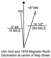 |
| Figure 1. Declination. |
 |
| Figure 2. Reproduced section of U.S.G.S. quad "Firth, Idaho." Site locations will typically emphasize topographic landmarks and permanent features like maintained roads, wells, streams, and telephone lines. |
Often the field crew will use a hand-held compass or Brunton for laying out site datums, reference lines, and maps.
-The archaeological site must be plotted on a U.S.G.S. quad sheet and the legal description (T-R or UTM) noted. Location should include a brief description of site locale, emphasizing easily recognizable landmarks (topography, streams, roads) and describing access to the site area.
-The crew will have to decide if reference is to magnetic north or true north, adjusting for declination as indicated on the U.S.G.S. quadrangle (quad sheet).
-The crew uses the Brunton to shoot a cardinal reference line (N-S or E-W). A stake marks the datum to be established and another marks the end of the line. If this baseline is to be used for a test trench, the crew may run a metric tape from stake to stake, marking off one meter excavation units or squares.
-The grid should be numbered within the NE quadrant, assuming a reference datum set well off the site surface to the SW. Usually, the grid datum is set as 100N 100E. This convention will allow for expansion back to the SW if necessary and ensures consistency by allowing only grid references drawn within the quadrant defined by the North and East axes.
-(Figure 2) A sketch map should be made of the site prior to excavation. This sketch map should indicate major artifact concentrations, locations of stream channels and roads or other features, and the layout of the cardinal grid line.
-It is very important at this juncture that the field crew note all surface evidence that might pertain to the nature of site disturbance.
-If testing is required, grid units should now be selected for excavation. Generally, any testing should try to randomize the distribution of excavation units. This proviso should also be intepreted, however, with common sense. If cultural features are visible on the surface or in stream erosion banks, or if artifact distributions show obvious clustering, the sample should be stratified and encompass arbitrary placement of excavation units.
Site Recording Procedures: Keeping Control
The key to successful excavation is maintaining accurate measurements or provenience information throughout the exercise. Two reference systems must be slavishly adhered to:
-All horizontal and vertical measurements must be taken from the primary or secondary site datums.
-All excavation squares and excavation levels must be labeled within the establish quadrant of one meter grid squares.
 |
| Figure 3. The site grid reference system. |
Concern for adequate CONTROL must also dictate excavation strategy:
Mundane but very important: Make sure that the excavation unit is absolutely square (an error at the beginning is a fatal flaw in the analysis and publication). Excavators should use two metric tapes and the concept of a 3-4-5 triangle to square unit corners.
Mundane but equally important: Make sure that all excavation units are designated by their southwest corner referenced within the NE site grid system. A common mistake is to confuse excavation unit coordinates as excavation progresses.
Mundane again, but oh so common a mistake: Make sure that the strings on the stakes are crossed on the inside so that excavation margins do not prematurely remove the stakes.
If level readings are being taken from the SW corner of the excavation unit, be sure to notch the corner stake rather than letting the level string slide down as the site surface erodes. This string elevation will be shot relative to the primary datum elevation.
Excavation will normally proceed in arbitrary 5 cm or 10 cm horizontal levels within the excavation units. As excavation expands into adjacent units, arbitrary levels will generally be abandoned for natural or cultural levels. A this point, elevations will be taken on the surfaces of the naturally sloping and diving strata.
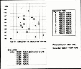
 |
| Figure 4. Plotting the position of artifacts on the floor of an excavation unit. |
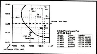
Figure 4 indicates how control is kept on accurate measurement of the vertical and horizontal provenience of artifacts within the excavation units. A number of artifacts are plotted on the north and east axes of unit 100N 100E. Each artifact has been given a specimen number (FS 160) unique to the unit and stratum. Feature boundaries (F16) are roughed in as indicated.
As excavation proceeds, the crew is recording tactics and observations in the feature system forms. Done correctly, this record supplies the information that will be sought by analysts, report writers, and other researchers.
Rigor is essential. Remember that excavation is destruction, and is only justified if the utmost care is taken to record all relevant information.
Recommended References
Barker, Philip 1993 Techniques of archaeological excavation. London: Batson.
Hester, Thomas, Harry J. Shafer and Kenneth L. Feder (eds.) 1997 Field methods in archaeology. 7th ed. Mountain View: Mayfield.
Jaukowsky, Martha 1980 A complete manual of field archaeology. Englewood Cliffs: Prentice Hall.
Recording will require drawing a stratigraphic profile. Inevitably, real life distinctions will be simplified, and the lines will only grossly represent significant features and strata.
Excavators will construct their profile excavation unit wall by excavation unit wall. Ideally, the stratigraphic sections will record points of intersection and the angle of repose across the full extent of the unit. Figure 1 presents an idealization of stratigraphic profiling procedures (horizontal and vertical reference lines).
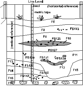 |
| Figure 1. A schematic stratigraphic profile showing drawing and recording conventions. |
As shown, a great deal of information can be presented in a properly drawn strat profile. A line level sets the horizontal reference line, which is marked off in 10cm units and vertical reference lines are established along which measurements are taken with a metric tape. Points are established that mark the uppermost, lowermost, and horizontal extent of all cultural and natural features. FS numbers assigned are shown on the profile as symbols indicative of diagnostic artifacts or radiocarbon samples. The profile should supply all information that the excavator or analyst needs to maintain control of the excavation and subsequent analysis. The depiction of key reference points is simplified by conventions like vegetation drawn on the surface and diagonal lines drawn through stones in the sterile level.
Each profile page should have a key to symbols and an descriptions of important features and field specimen lots. Notes should be indexable and usable for subsequent analysts. For example, radiocarbon samples with high potential should be identified on the strat and on the accompanying notes section. Similarly, diagnostic artifacts should be located on the strat and listed by their field specimen number.
Profiles are generally drawn on Continuation Sheets to a 1:10 scale consistent with that used in Field recording form #2. This form is used for drawing plan maps of feature extent, surfaces or excavation levels. Use of a consistent scale is key since we want to be able to scan these records into our computer data base and later draw profiles and plan maps depicting broad sections of site stratigraphy and activity surfaces.
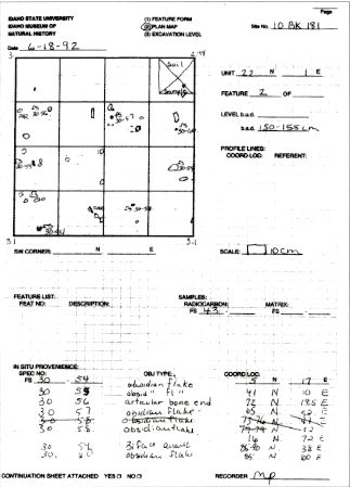 |
| Figure 2. Filled-out Form 2 from excavations at the Indian Rocks site, 1992. |
Figure 2 shows an example of a completed Form #2 from excavation at Indian Rocks in 1992. The excavator has recorded the location of diagnostic specimens plotted for level 150-155cm b.s.d. in unit 22N1E. Artifacts were recovered as FS 30. A radiocarbon sample was recorded as FS 43. Note that a soil sample was removed from the northeastern corner, that no feature numbers were defined in this level plan, and that no profiles were drawn recording the surface since the level was arbitrary and cut level with the site datum. A continuation sheet was attached to the Feature 2 as a complete listing of all FS lots.
List of Recommended References
Boggs, Sam 1995 Principles of sedimentology and stratigraphy. Englewood Cliffs: Prentice Hall.
Courty, Marie A., Paul Goldberg and Richard Macphail 1989 Soils and micromorphology in archaeology. New York: Cambridge University Press.
Hassan, Fekri 1978 Sediments in archaeology: Methods and implications for paleoenvironmental and cultural analysis. Journal of Field Archaeology 5:197-213.
Keeley, Helen and Richard Macphail 1981 A soil handbook for archaeologists. Bulletin 18. Institute of Archaeology, London.
Stein, Julie 1988 Interpeting sediments in cultural settings. In Julie K. Stein and William Ferrand (eds.), Archaeological sediments in context. Orono: Center for the Study of Early Man.
Culture History of Idaho
![]()

| Projectile Points | Pottery | Ground Stone |
| Other Stone Tools | Bone Tools |
Material Culture is that whole domain of things made and used by human beings. Culture History is defining the material culture in temporal (time) and spatial frameworks.
Temporal-Chronological Frameworks- By E.S. Lohse
Originally published in Tebiwa 25(1) as part of the article "Northern Intermountain West Projectile Point Chronology"
Willey and Phillips (1958:11-18) declared that the overriding first step for archaeological research in a region was the development of a regional chronology. Basic building blocks were to be the phase or cultural period of defined temporal and spatial extent, the stage or larger temporal and spatial unit defined as a perceived level of societal complexity, the tradition or postulated historical connection between cultures, and the horizon or postulated historical connection across space usually defined as a shared style. This heuristic scheme, adopted whole or in modified form, has become the organizing framework for culture-historical reconstructions throughout North America. In practice, separate research areas or regions can be correlated in the form of a chronological chart that shows the temporal and spatial distnbution of artifact types and styles. Willey and Phillips' scheme has served its purpose: the careful layout of temporal and regional differences in the distribution of artifact types, styles, and cultures. However, they suggested this only as an initial step in areal and regional syntheses, and it may be argued that research has stunted its development by continuing to correlate archaeological types and postulated cultures rather than employ more effective measurement techniques that might better address contemporary research issues. Basic chronological frameworks using the Willey and Phillips (1958) scheme have been worked out and summarized for the Northern Intermountain West and Northwestern Plains (e.g., B. Fagan 1991a; Frison 1991; Jennings 1986,1989; Leonhardy and Rice 1970; Reeves 1970). Most researchers will agree in principle with Jennings' (1989:11) schematic representation of correlating archaeological traits and cultures for chronology building, and his definition of Paleoindian, Archaic and Formative stages for the North American continent. Squabbles break out over proper correlation or interfingering of regional and areal sequences, recognition of the best diagnostic types, any correctness of assigned dates, but the goal of broad regional comparison and synthesis holds. The clearest imposition of this standard culture-historical framework for the Intermountain West is Jennings' (1986:Fig. 2) chronological sequence for the Great Basin inclusive of the Upper Snake and Salmon River area. Here Jennings defines a Pre-Archaic or Paleoindian stage, and an Early, Middle and Late Archaic stage for all of the Great Basin, which subsume various phases and periods for six different areas defined by distinctive research histories. Jennings (1986: Figs. 3 and 4) correlates significant projectile point types with these stages and chronometric dates. Cultures are mentioned throughout, loosely and implicitly correlate with archaeological types, traits and site assemblages. Chronology building is certainly a necessary first step for broad scale synthesis but it cannot be the only goal for archaeological research, nor can we assume that the classes, styles and types defined are fully refined measures or the best measures that might be applied. The culture-historical review that follows outlines regional sequences and projectile point types defined for the Columbia Plateau and Great Basin of the
Western Snake River Prehistory
Daniel S. Meatte
(taken from the Prehistory of the Western Snake River Basin (1990) pp.63-70)
THE ETHNOGRAPHIC MODEL
The random descriptions of Native American peoples in the study area recorded in historic journals of western fur traders and explorers (Fremont 1970; Ogden 1950, 1961, 1971; Stuart 1935; Talbot 1931; Wyeth 1851) and more comprehensive, systematic descriptions made by ethnographers after the turn of the century (Liljeblad 1957; Lowie 1909; Murphy and Murphy 1960; Stewart1941) have cumulatively formed a rich and varied ethnographic record. Archaeologists have attempted to use this ethnographic record, by way of analogy, as a comparative model for aboriginal lifeways that might strengthen a variety of archaeological inquiries (Chang 1967; Fowler and Jennings 1982:121).
The ethnographic record has also served archaeologists as an ethnographic datum from which cultural and material affiliations can be traced backward in time, using the Direct Historical Approach (Steward 1941; Strong 1935). Using Steward's model of Shoshone lifeways, Jesse Jennings conceived of a generalized adaptive model, the Desert Culture Concept, of prehistoric peoples occupying the arid lands of the Great Basin region (Jennings 1957). Similarly, most archaeologists working in the study area have implicitly operated with the Steward model and the Jennings Desert Culture Concept when interpreting archaeological assemblages (Butler 1978b; Plew 1976a; Swanson 1965; Tuohy 1963).
A more critical test of Steward's model was applied by Plew with data from the Owyhee Uplands region of southwestern Idaho (1980a:80). Plew found that some, but not all, aspects of the Steward model pertinent to the region could be archaeologically demonstrated (1980a:80).
Ames has recently suggested that any "confirmation of Steward is inevitable and perhaps trivial" (1982a:86). He bases this critique in the belief "that the patterns described ethnographically for the area are generally those of any mid-latitude foragers" (Ames 1982a:86). Ames suggests that if we are to assess the applicability of Steward's model to the archaeological record we must build and employ explicit tests and/or build settlement models "without reference to the ethnographic record" for comparison (Ames 1982a:86).
Clearly, with only one critical test available, any judgment about the relevance of Steward's model is premature at this time. A need for comparative testing of the Steward model in most of the principal ecological settings of the study area (i.e., riverine settings, high intermontane prairies, and lowland deserts) exists, and future researchers should pursue such endeavors (for examples see Bettinger 1977; C. Fowler 1982; Janetski 1983; Thomas 1973).
REGIONAL TRADE AND EXCHANGE SYSTEMS
While traversing the Snake River Plain in the early 1800s, fur traders and early explorers observed and documented the existence of two major trading centers in the study area. The first was in the vicinity of Camas Prairie, near Fairfield, Idaho, and the second was along the lower reaches of the Weiser and Payette rivers on the Idaho-Oregon border. Later ethnographic surveys confirmed the presence of these trade centers and provided more detailed accounts of the type of goods traded, the nature of the trading activities, and the cultural affiliations of those people present (Liljeblad 1957; Murphy and Murphy 1960; Steward 1938, 1941; Stewart 1941).
Much of what we know about the regional trade and exchange systems is restricted to information extracted from these historical narratives and a few ethnographic surveys. This information indicates the Weiser area and Camas Prairie trade centers were successfully articulated with other regional trade centers (Griswold 1954; Hughes and Brennyhoff 1986; Walker 1967) that together operated as a "continental network" (Wood 1972:155). The Weiser area and Camas Prairie centers served as geographic focal points where foodstuffs, raw materials, manufactured goods, and environmental information could be exchanged (Liljeblad 1957). Further, they provided a social forum for gambling, dancing, intermarriages, social intercourse, and affirmation of social ties (Liljeblad 1957; Wood 1972).
Archaeologists have recently begun to document the antiquity of these trade centers, establishing that one of these centers, the Weiser area, operated as early as 4,500 years B.P. (Pavesic 1985). The use of x-ray diffraction to identify volcanic glasses, such as obsidian and ignimbrite, indicates the routes and the spatial extent of these exchange systems (McDonald 1985, 1986; Sappington 1981a, 1981b, 1984). A "Blue Mountain north-south trade axis" transmitted obsidian from Timber Butte in southeastern Idaho as far north as the Clearwater River and to the Pacific Coast, via the Columbia Plateau, while Ollivella shell beads were traded southward to the Weiser area (Pavesic 1985:82).
Available archaeological evidence clearly demonstrates a temporal co-occurance of these trade centers with regional developments of sedentism, increasing social complexity, and the use of cemeteries in the study area (Pavesic 1985:81-82). Just how and why these changes manifested themselves is not clear.
THE FREMONT CULTURE
Interest has been recently renewed in the nature and presence of the Fremont Culture in southern Idaho. This interest has manifested itself as a heated debate over conflicting interpretations of diagnostic artifacts, such as pottery sherds, basketry, and projectile points. The artifacts in question purportedly represent either an influx of Fremont peoples (Butler 1979c), or an influx of goods and technology (Plew 1979d), into southern Idaho. This debate stems from three papers published in 1979, one by Mark Plew (1979d) and two by B. Robert Butler (1979a, 1979c). In the first paper, Plew found the designation Shoshoni Ware far too inclusive of a pottery type for southern Idaho. He proposed a new pottery type, Southern Idaho Plain, "be recognized to distinguish a more finely made pottery than the classic thick-walled, flat-bottomed vessels characteristically referred to as Shoshoni Ware." (Plew 1979d:329). Further, Plew suggested that Southern Idaho Plain may have its origins or at least affinities with the Fremont culture of northern Utah (Plew 1979d:332-334).
Butler similarly concluded that "two distinct wares, each exhibiting considerable variation in form and decoration" could be discerned for this region. He labeled one type Intermountam Ware and a speculated second type was associated with the Fremont pottery traditions of Northern Utah (Butler 1979a:9). In a second paper, Butler elaborated on his thoughts by proposing that "the northern frontier of the Fremont culture extended as far north as the Snake River Plain in the Middle and late Archaic periods and that this culture contributed to the make-up of Northern Shoshoni culture in late prehistoric and early historic times." (Butler 1979c:8).
The importance of these three papers is readily apparent. Both authors agreed that a discernible variation was present within the existing pottery type called Shoshoni ware (or Intermountain Ware, or Southern Idaho Plain). Each author presented laudable means of classifying that variation. Particularly significant is that both authors drew similar conclusions from significantly different sets of data which only partially overlap in the south-central portion of the state. Plew focused on pottery collections recovered from southwestern Idaho while Butler utilized pottery collections from southeastern Idaho. Their agreement that the Fremont Culture of Utah somehow contributed to the variation that they were documenting, either directly, or indirectly, cannot be overlooked.
Regrettably, these two authors spurred a series of comments and rebuttals which questioned the methodology, data, and at times, character of each other (Butler 1980d, 1981b; Plew 1980d, 1980e, 1981d). And, these rebuttals drew additional comments from others as well (Adovasio et al. 1982; Harrison and Hanson 1980).
A related shortcoming of this debate has been the recent reinterpretation of important taxonomic phases in the late archaic sequences of southern Idaho based upon spurious claims (Butler 1980b, 1981a; 1983b). This reinterpretation is based on the direct linkage of scattered finds of pottery sherds recovered from southern Idaho to stylistically similar types from known Fremont sites in Utah. This linkage, once established, is then used to redefine artifact assemblages associated with the newly defined Fremont pottery. An example is Butler's reanalysis of the pottery sherds from Wilson Butte Cave [The first paragraph below is from a memo written by Frank Hull to Jesse Jennings, dated June 13, 1980, and quoted by Butler. The following paragraph is text by B. Robert Butler].
Rex Madsen examined under a microscope nine of the sherds that Dr. (sic) Butler sent down for identification from Wilson Butte Cave. Without question, Rex identified the sherds as Great Salt Lake Gray. Temper is rounded sand with quite a lot of mica. Some of the sherds have the characteristic light orange-brown color. The exterior of some of the sherds has striation but generally the vessels were smoothed and scraped, typical of Great Salt Lake Gray. The incised rim decoration is also typical. Sherds 10382, 10053 and 10003 are "type quality" Great Salt Lake Gray.
Thus,certain crucial material culture items characteristic of the Dietrich phase in southcentral Idaho now have been determined to be, on the basis of independent study and extensive reanalysis, definitely Fremont, rather than Shoshonean [Butler 1981c:2-3].
Ironically, Butler has committed the same mistake that he charges other authors of making in this same article.
Using the mere occurrence of so-called "Shoshonean" pottery at certain southern Idaho sites as an indicator of Shoshonean presence (e.g., Madsen 1975; Wright 1978) is obviously a mistake; we will need to have both pottery and basketry, in combination with a range of other material, well analyzed before a case can be made for either a Shoshonean presence at any particular prehistoric site in southern Idaho or for its purported interaction with Fremont inhabitants of this region [Butler 1981c:3] [Emphasis added].
Of further concern is the unquestioning acceptance, at face value, of these interpretations. Aikens and Wither-spoon have recently incorporated Butler's purported documentation into their hypothesis on Numic prehistory (1986). They extend the territorial range of the Fremont into all of southern Idaho (Aikens and Witherspoon 1986:Figure 3).
Though mildly entertaining, this rather caustic, misguided debate has obscured the original contributions of Butler and Plew with a massive bulk of diatribe. The result, of course, is an important archaeological topic brought to a state of utter confusion. Less now is understood about Fremont relationships, if any exist, on the Snake River Plain, than ever before.
At the heart of this debate are differences of opinion with respect to the interpretation of pottery types, largely recovered as isolated finds and in few archaeological contexts. If these interpretations are to be resolved, they will require a comprehensive analysis of existing pottery collections, a large set of radiocarbon dates clearly associated with the various pottery types from excavated contexts, and finally, a more constructive dialogue geared to a common endeavor (see Pailes 1981:468, for some pertinent observations on the character of recent archaeological debates). Is there a Fremont presence in southern Idaho? At present, no. While Butler has presented a long, tenuous, inventory of "Fremont pottery from southern Idaho, he has not presented any evidence which would support a contention that these sherds and/or basketry fragments show temporal and areal relationships with demonstrable patterning that can be called Fremont. Nevertheless, a recent and extremely insightful, functional analysis of Shoshone pottery by Butler (1987), has demonstrated some of the fruitful avenues of inquiry that can be pursued. Hopefully, future pottery studies in the region will pursue more of this type of work.
THE MIDVALE COMPLEX
The Midvale Complex was first defined by Warren, Wilkinson and Pavesic based on excavations conducted at a series of sites near Midvale, Idaho (Warren et al. (1971). The sites displayed a range of activities that included the quarrying of basalt nodules for stone tool production, and manufacturing, hunting, and root and seed processing (Bucy 1971b, 1974; Warren et al. 1971:50). The Midvale Complex was defined on the basis of a distinct artifact assemblage bearing perceptible areal and temporal relationships (Warren et al. 1971:39). The assemblage contained large side-notched points (Bitterroot), Cascade points, leaf-shaped points with side notches that form an expanding stem, scrapers, choppers, edge-ground cobbles, elongate scrapers, and a variety of unifacial and bifacial blanks or roughouts (Bucy 1971b, 1974; Ruebleman 1973; Warren et al. 1971:51). Also present in this assemblage are pestles, manos, milling stones, two forms of mortars, gravers, drills, pitted pebbles and possibly edge-ground cobbles (Warren et al. 1971:51). Age assignments for this complex are placed at 4,500 to 2,000 years B.P. based on typological cross-dating (Warren et al. 1971:52).
At the time of writing (1971), only one other site was known to contain a similar assemblage of artifactual materials, the Stockoff Quarry near LaGrande, Oregon (Bryan and Tuohy 1960). Since then, the temporal and spatial definitions of the Midvale Complex have been greatly refined. The assemblage has been documented at a variety of sites throughout eastern Oregon and southwestern Idaho (Arnold 1984; Brauner 1985; T. Green et al. 1986; Mead 1975; McPherson et al. 1981; Pavesic 1979, 1985; Pavesic and Meatte 1981; Plew 1977c; Ruebleman 1973; Wonfack 1975,1977; Wylie 1984).
Currently, the geographic distribution of this complex now includes most of the Blue Mountains region in eastern Oregon, Hells Canyon along the Idaho-Oregon border, and much of southeastern Idaho. The temporal span of this complex appears focused between 4,500 to 2,500 years B.P. (2,500 B.C. to 500 B.C.) but subsistence and settlement characteristics of this complex remain poorly documented (Warren et al. 1971:53). Recently, the Midvale Complex has been linked to the newly defined Western Idaho Archaic Burial Complex found in southeastern Idaho (Pavesic 1985). This linkage has added valuable information to the Midvale Complex about obviously complex social dimensions in burial practices at this time interval.
Though not completely understood, it appears the Midvale Complex marks the coalescence, by 4,500 years B.P., of a regional subsistence and settlement pattern focused on regional exchange (Pavesic 1985:81). Among its characteristics are the simultaneous appearance of large pit house structures (T. Green 1982a), an array of highly stylized point types (Ruebleman 1973; Warren et al. 1971), diversification of ground stone tools (T. Green 1982a; Warren et al. 1971), and cemeteries containing elaborate burials with a wealth of burial furniture (T. Green et al. 1986; Pavesic 1979, 1985). The development of this pattern is contemporaneous with a broader pattern noted for most of the Columbia Plateau (Ames and Marshall 1980-81; Bense 1972; Ruebleman 1973; Schalk 1980; Sehalk and Cleveland 1983). This pattern is characterized by increased residential sedentism associated-with intensified resource exploitation, primarily salmon and root crops (Ames and Marshall 1980-81; Schalk 1980; Schalk and Cleveland 1983).
WESTERN IDAHO ARCHAIC BURIAL COMPLEX
Clearly associated with the Midvale complex is a remarkable burial complex recently defined by Pavesic (1985). The pattern dates:
between 4,500 and 4,000 B.P., with possible extensions until 3,500 B.P. Identified cultural attributes include massive turkey-tail and cache blades, caches or obsidian blank/ preforms, large side-notched projectile points, flexed or seminexed inhumations, possible cremation, and canid skull interments. Additional characteristics include use of red ochre, Ohvella shell, pipes, and specular hematite crystals. Human burials are placed in unmarked cemeteries with a preference for high sandy knolls along river terraces. Natural interment features have not been culturally modified, and no tombs or chambers of any type are known to exist. This complex is presumably related to workshops/camps in the Weiser Basin, since there are no excavated village occupations in the immediate region (1985:80-81).
The association of these specialized burial features within the Midvale Complex is based on a number of shared traits including large side-notched projectile points, Cascade and other bipointed projectile point varieties, turkey-tail points and corner-notched points. Also recovered are large numbers of bifacial and unifacial worked basalt production forms plus a variety of tools recognized as scrapers, choppers, cores, and "elongates." (p. 38).
This mortuary complex is strongly expressed at archaeological sites found in and around Weiser, Idaho. A recent discovery of a large burial site near New Meadows, Idaho, has effectively increased the areal extent of the complex and provided effective linkages with similar archaic burials on the southern Columbia Plateau, specifically Marmes Rockshelter (T. Green, Pavesic et al. 1986). An age assessment of 5,965 ± 60 years B.P. (WSU #3426), and the typological composition of the artifact assemblage at the DeMoss site, suggests an earlier assemblage of the elaborate mortuary ceremonialism recognized in the near-by Weiser area (T. Green et al. 1986:38-40).
Just how this mortuary complex developed and was dispersed is unknown. Similar, contemporaneous mortuary complexes are increasingly being recognized across much of North America (King 1970; Sanger 1968; Tuck 1971, 1978). The idea of a pan-continental mortuary network is a provocative and compelling notion worth further enumeration (Max Pavesic, personal communication 1987).
ANADROMOUS FISHERIES
Julian Steward's ethnographic model of Great Basin Shoshone (1938) is frequently used in conjunction with Jesse Jenning's (1957) archaeological model of a Desert Culture concept to frame the archaeological record in southern Idaho (Butler 1968; J. Green 1972; Plew 1976a; Webster 1978). The borrowing of these concepts is a natural assumption based on the known presence of Numic populations in southern Idaho at contact times (Kroeber 1939; Steward 1938; Stewart 1970), and the recognition that material culture from excavated sites in southern Idaho exhibited many similarities to archaeological assemblages in the Great Basin (Butler 1968).
This has resulted in a deeply imbedded perception by archaeologists that anadromous fisheries occupied a minor role in the prehistoric diet (see Pavesic 1978b for discussion of this problem). Only recently has attention been focused on the identification and examination of evidence for fishing in the study area (Meatte 1982, 1983, 1986a, 1987; Pavesic 1978b, 1986a; Pavesic et al. 1987; Plew 1980f, 1981c, 1983c, 1987a). Summaries of recovered fish remains and fishing equipment from southern Idaho are documented by Plew (1983c) and Pavesic (1986a). Currently, anadromous fish remains identified at excavated sites include the Clover Creek Site, 10-EL-22, (Butler 1983a:4); Three Island Crossing 10-EL-294, (Meyer and Gould 1987:4); Givens Hot Springs, 10-OE-1689, (Thomas Green, personal communication 1988); Nahas Cave, 10-OE-1674, (Plew 1980f, 1986b:97, 1987a), the Bliss site, 10-GG-1 and 10-TF-352 (Huelsbeck 1981:270-284); Cave #1, 10-OE-240 (Schelibach 1967; Pavesic et al. 1987); Deer Creek Cave, 26-EL-25, (Follett 1963:31-32); and Pence-Duerig Cave, 10-JE-4, (Randall Schalk, personal communication 1988). A single vertebrae recovered from Dry Creek Rockshelter, 1 0-AA-67, (Webster 1978:18), may also be salmonid, but identification is indeterminate.
Non-anadromous fish remains identified from excavated sites include: Lydle Gulch site, 10-AA-72, (Brown 1981:238); Kanaka Rapids locality, 10-GG-273, 278, (Butler and Murphey 1983:42); Dirty Shame Rockshelter, 35-ML-65, (Hall 1977:7); Bliss site, 10-GG-1 and 10-TF-352 (Huelsbeck 1981:270-275); and the Crutchfield site (Murphey and Crutchfield 1985:149).
Additional fish remains have been recovered from several other sites, but these remains have not been identified. They include Swan Falls Dam site 10-AA-17 (Ames 1983:27); 10-TF-129 (Bucy 1971a:8); the Braden site, 10-WN-1 17 (Harten 1975:48); and Hagerman National Fish Hatchery (Pavesic and Meatte 1980:4 1).
What is known about fishing in the study area? The ethnographic record for the region clearly documents the use of anadromous and non-anadromous fishes by most groups occupying the region (Liljeblad 1957, 1959; Murphy and Murphy 1960, 1986; Steward 1938, 1941, 1943; Stewart 1941). This documentation also includes several ethnographic groups from outside the region (Northern Paiute, Ft. Hall Shoshone) that traveled to the area with the specific intent of harvesting fish resources (Hultkrantz 1956:20-21; Liljeblad 1957:63, 84-85). The inventory of fishing equipment included a vast array of gear such as fish hooks, bipointed and barbed spears, harpoons with detachable composite points, dip nets, lifting nets, seine nets equipped with floats, weirs, basket traps, and fixed platforms (Hewes 1947; Liljeblad 1957; Murphy and Murphy 1960; Rostlund 1952; Steward 1938; Stewart 1941). Equipment associated with the processing of fish included drying racks, split roasting sticks, fish skin bags, deep bowl mortars, cache pits and framed storage sheds attached to house structures (Liljeblad 1957; Murphy and Murphy 1960; Steward 1938; Stewart 1941). This equipage together with first-hand observations made by early travelers in the region, evidence an efficient, well-defined adaptive pattern of fish exploration (Pavesic 1986a).
Verifying the time depth of this pattern (or any other) in the archaeological record has proven to be a difficult task (Pavesic 1986a). Despite the perishable nature of fish remains and the material culture associated with it, the absence of fish remains and tackle in the archaeological record is understandably deemed negative evidence of fishing activities. A more heightened awareness of fishing activities on the part of archaeologists working in the region (Pavesic 1978b; Plew 19801) has led many to employ more refined collection strategies at excavations (Ames 1983; T. Green 1982a; Plew 1981c) as well as more innovative ways of examining the archaeological record (Meatte 1982; Pavesic 1986a).
Faunal information recovered from dated contexts indicate the use of chinook salmon (Oncorhynchus tshaHytscha) as a food resource by 4,200 years B.P. at the Givens Hot Springs locality on the main stem of the Snake River (F. Green 1982a; Tom Green, personal communication 1987). This date can probably be extended to ca. 7,000 years B.P. based on the recovery of chinook salmon at Bernard Creek Rockshelter in Hells Canyon along the Idaho-Oregon border (Casteel 1977; Randolph and Dahlstrom 1977). A large sample of chinook (Oncorhynchus tshawytscha) remains were recovered there with two radiocarbon dates of 7,250 ± 80 years B.P. and 7,190 ± 135 years B.P. (Sheppard 1977:96). Though Bernard Creek Rockshelter is downstream from the study area, it would seem safe to speculate chinook salmon were able to ascend the remaining portion of the Snake River up to the natural barrier at Shoshone Falls at those times (Pavesic 1986a).
Steelhead trout (Salmo gairdnerii) were available in the area by 2,920 ± 70 years B.P. as evidenced by their recovery from excavated contexts at Nahas Cave (Plew 1987a:19). Plew's assertion that the steelhead trout remains date between 2,920 and 4,990 years B.P. is, however, misleading (Plew 1987a:19). Plew indicates that Steelbead trout (Salmo gairdnerii) remains were recovered from arbitrary level 50-60 cm (1987a:19). A radiocarbon date from a hearth in this arbitrary level is dated at 2,920 ± 70 (TX 3637) years B.P. (Plew 1986b:29, 1987a:19). No fish remains of Steethead trout (Salmo gairdnerii) are reported by Plew for the remaining nine intervening 10 cm arbitrary levels (Plew 1986b, 1987a). In arbitrary level 150-160 cm, Plew reports a radiocarbon date of 5,990 ± 170 years B.P., but no Steelhead trout (Salmo gairdnerii) are documented for this level (Plew 1986b, 1987a:19). Clearly, there is no documented evidence at Nahas Cave to suggest the age of steelhead trout (Salmo gairdnerii) extends or ranges to 5,990 ± 170 years B.P.
Understanding the overall relationship between the local anadromous fishery and the indigenous subsistence system(s) means we must draw from a larger faunal record that is well secured in time with radiocarbon dates. We should remember the Western Snake River Basin represents the upstream limits of the Columbia River anadromous fishery in the southern Plateau. Efforts to understand the importance of this anadromous fishery to prehistoric lifeways are hindered by the borrowing of conceptual frameworks from Great Basin archaeology (Jennings 1957; Steward 1938). To understand the local prehistoric subsistence system(s) linked to this anadromous fishery, we must examine other prehistoric subsistence systems linked to this same anadromous fishery. This means the archaeological record found along the upstream edge of the Columbia River watershed will be of considerable importance to interpreting the archaeological record in the Western Snake River Basin (Swanson 1965). At present, the prehistoric record in the Western Snake River Basin is too steeped in definitions and conceptual frameworks borrowed from the Great Basin. Until this record is understood as a regional system, linked to the Columbia Plateau by way of subsistence, it will not provide us with an accurate measure of the archaeological record (Pavesic 1978b).
A DEVELOPMENTAL MODEL FOR THE WESTERN SNAKE RIVER BASIN
The archaeological sequence described in the preceding chapter is collapsed into a three-stage developmental model of settlement and subsistence systems as first proposed by Randall Schalk for the southern Plateau (1980:25-41), and later applied to most of the Columbia Plateau (Schalk and Cleveland 1983:23-44). The model is formulated to identify the basic evolutionary changes of adaptive systems as evidenced in the archaeological record (Schalk and Cleveland 1983:44-45).
This is accomplished by identifying relatively homogeneous subsistence and settlement patterns over broad geographic areas (Schalk and Cleveland 1983:45). For the Columbia Plateau, Schalk and Cleveland identified three major adaptive systems: (1) Broad Spectrum Foraging (11,500-4,200 years B.P.), characterized by mobile foragers who used simple tool inventories and exploited a wide variety of food resources; (2) Semisedentary Foraging (4,200-250 years H.P.), characterized by foragers who were able to extend residential stays during the winter months by storing foods. Archaeological evidence of these extended residential stays is characterized by the presence of housepits, storage facilities, diverse artifact assemblages, cemeteries, and increased reliance upon fish resources; (3) Equestrian Foraging (250-100 years H.P.), characterized by heavy reliance on horses as an efficient transportation method which permitted either fall and winter hunting in the upland ranges or the formation of large coordinated horse-mounted groups that pursued bison outside the local foraging range for extended periods of time (Schalk and Cleveland 1983:23-39).
Schalk and Cleveland have cautioned that this model is "imposed" on the archaeological record, causing some distortion of "long-term trends and processes" (1983:44). They further note that it (the model) does not imply complete regional uniformity; it simply focuses on homogeneous qualities discernible over wide geographic areas (Schalk and Cleveland 1983:45). This model was selected over numerous others (Butler 1986; Cressman et al. 1960; Jennings 1957; Madsen 1982; Nelson 1969, 1973; Sanger 1967; Thomas 1982; Zilverberg 1983) because it is designed for a specific regional system, the Columbia-Frasier Plateau, which includes the western Snake River Basin. In applying this model to the study area, all three adaptive systems were easily distinguished in the archaeological record. Further, the temporal developments of these adaptive systems were relatively synchronic with those described by Schalk and Cleveland for the Columbia Plateau.
BROAD SPECTRUM FORAGING (11,500-4,204) YEARS B.P. OR 9,550-2,250 B.C.)
Evidence for the arrival and subsequent "settling in" of the first inhabitants in the study area is difficult to characterize because of the sample size. The archaeological evidence itself is often subject to highly variable definitions and interpretations. Conservative and liberal interpretations of the archaeological evidence are commonly seen. The conservative interpretation is best exemplified by the work of C. Vance Haynes, who strongly argues for a minimal set of criteria by which all potential early man sites must be judged (Haynes 1969). When measured against these criteria, Haynes has found no evidence for man's presence in North America dating earlier than 11,500 years H.P. (Haynes 1980). In contrast, a number of proponents have marshalled evidence for man's presence in North America ranging from 19,000 years H.P. at Meadoweroft Rockshelter in southwestern Pennsylvania (Adovasio et al. 1983) to over 100,000 years B.P. for such sites as Calico in southern California (Simpson 1978).
A conservative interpretation of the cultural materials associated with the two early dates from Wilson Butte Cave would find the assemblage not acceptable as firm evidence of early peoples' presence in the study area at ca. 14,500 years H.P. The paucity of the artifactual remains, the pooling of the bone collection for a radiocarbon date, together with the difficulty in reconciling a temporal gap of nearly 4,000 years between the two early dates at Wilson Butte Cave (ca. 14,500 and 15,000 years B.P.) and the next oldest radiocarbon dates in the study area (ca. 10,000 years B.P. at Deer Creek Cave and 9,500 years H.P. at Dirty Shame Rockshelter), challenge the early age assessment. And comparing other early dated sites from the surrounding region (Fort Rock Cave ca. 13,000 years B.P.; Wasden Site ca. 10,000 to 12,000 years B.P. and Jaguar Cave ca. 11,580 ± 250 years B.P.) still leaves a significant temporal gap to explain.
The assemblage from Wilson Butte Cave simply does not present a strong case for man's presence in the study area at such an early time. Until further evidence from other sites in the region dating ca. 14,000 to 15,000 years H.P. can be brought forth, together with evidence for the later intervening temporal gap (14,000 to 10,000 years H.P.), the early age assessments at Wilson Butte Cave will remain unfounded.
In general, this period is marked by an increasing diversity of diagnostic point styles through time: Clovis, Folsom, Windust, Haskett, Cascade, and Northern Side-notched. There are temporal overlaps and variable degrees of persistence in several of the styles, but at present, the archaeological chronology is too coarse to precisely stipulate the temporal arrangements of these point styles. Whether each style persists briefly and then gives way to another or there are a synchronic plurality of styles is not clear at this time.
Equally meager is our understanding of regional settlement and subsistence systems. It is assumed that peoples responsible for the manufacture of the distinctive Clovis, Folsom, Windust, and Haskett type points pursued a highly mobile lifestyle while procuring an assortment of food resources. The hunting of big-game animals such as elephant (Mammuthus sp), bison (Bison antiquus), mountain sheep (Ovis sp), elk (Cervus sp), camel (Camelops sp), horse (Equus sp), and deer (Odocoileus sp), could presumably have been complimented by a variety of small game animals, roots, tubers, and berries. These assumptions are based upon evidence from adjoining regions where similar cultural assemblages are better documented (Butler 1978b, 1986; Dort and Miller 1977; Frison 1978, 1983; Miller 1982, 1983).
More detailed evidence for the remaining portion of this time period is available from Dirty Shame Rockshelter, in southeastern Oregon. The rockshelter is situated at an elevation of 1,433 m asl in an arid, steppe-like upland setting characterized by expansive tablelands heavily dissected by deep, stream-cut canyons (Kittleman 1977:1-2). The early occupational record documents a time range from 9,500 to 5,900 years H.P. which attests to a light, but steadily increasing occupational use of the rockshelter. A generalized pattern of exploiting a broad range of locally available plant and animal food resources is evident. Mountain sheep, (Ovis canadensis), antelope (Antilopcapra americana), deer (Odocoileus cf hemionus), rabbits (Sylvilagus idahoensis and nuttallii), crayfish (Astacus), mussels (?), sagebrush (Artemisia tridenta), wild rose (Rosa fendleri), and wild cherry (Prunus emarginata) are just a few of the food stuffs that were consumed at this site (Hall 1977).
The inhabitants of Dirty Shame Rockshelter used a simple assemblage of tool types, including projectile points, bifaces, and various flaked tools (Richard Hanes, personal communication 1987). Ground stone milling slabs are added to the assemblage inventory at approximately 7,500 years B.P. Residential features are absent until 6,800 years B.P., when shallow grass-lined pits first appear. Contents of these lined pits indicates their use for caching of personal articles and tools, presumably for later reuse, and the building of latrines. Evidence of bulk food storage or differentiated processing or cooking areas is not present. The occupational record at Dirty Shame Rockshelter ceases at ca. 5,900 years B.P., when an occupational hiatus of 3,200 years occurred, and resumes at ca. 2,700 years B.P. (Aikens et al. 1977:21).
A similar assemblage composition for this time period is found at Wilson Butte Cave (Gruhn 1961a:4-6). The Wilson Butte II assemblage, estimated to date at approximately 8,000 years H.P., is composed of several lanceolate points, a number of simple flaked tools, and one groundstone mano (Gruhn 1961a:l18-119). Occupational density is light with no cultural features present (Gruhn l96la:118-119). Faunal remains are sparse and indicate bison (Bison bison), and camel (?) were the utilized food resources (Gruhn 1961a:127).
SEMISEDENTARY FORAGING (4,200 B.P. - 250 YEARS B.P. OR 2,250 B.C.-A.D. 1700)
The earliest evidence for the emergence of Semisedentary Foraging can be seen in a distinct artifactual assemblage termed the Midvale Complex (Warren et al. 1971), found throughout the northern portion of the study area. This complex, which is dated at 4,500 to 2,500 years H.P., displays a diversified artifactual assemblage profoundly different from the generalized artifact assemblages seen in the Broad Spectrum Foraging period. The assemblage is characterized by a broad array of functionally discreet tools, which are employed in a variety of specialized site types including quarries, workshops, hunting stations, campsites, and plant processing sites (Warren et al. 1971). Just a few of the diagnostic artifacts that typify this diversified artifactual assemblage include: large side-notched points, an assortment of scrapers including the distinctive, unifacial "elongate" scraper; drills; punches; gravers; conical mortars; elliptical mortars; cylindrical pestles; manos; awl sharpening stones, and edge-ground cobbles (Ruebleman 1973; Warren, et al. 1971;). An impressive mortuary complex termed the Western Idaho Archaic Burial Complex (Pavesic 1985) was recently added to the Midvale Complex. This complex attests to the use of large burial cemeteries in which enormous amounts of exotic material wealth (burial furniture) were placed (Pavesic 1985).
At the Givens Hot Springs locality (10-OE-1689), a large pithouse (House #2) dates well within the temporal span of the Midvale Complex at 4,200 years H.P. (F. Green 1982a:41, 1988:Table 1). The pithouse measures six and one half meters in diameter, has steep side walls, a central roof support, a central hearth, and is associated with hopper-mortar bases, Northern Side-notch, and Humbolt series points (T. Green 1982a:41). Green also reports the presence, at the Givens Hot Springs locality, of several other pithouses of similar size and configuration dating at 2,200 years H.P. (10-OE-1689:House #4); 1,270 years H.P. (l0-OE-60:House #3); 1,150 years B.P. (10-OE-60:House #1) and 1,100 years H.P. (10-OE-1691 :no house # reported) demonstrating the persistence of this style until relatively recent times (Davis and Green 1988; T. Green 1982a:41-43, 1988:Table 1). Similar house forms have been found at Montour Valley (10-GM-61) and date to approximately 3,118 years B.P. (Artz 1983:110).
Other house forms from the study area are documented from this time span as well. At the Givens Hot Springs locality, Green also found circular, saucer-shaped house floors dated at 4,300 years B.P., and post 2,400 years B.P. (T. Green 1982a:42-43). Similar house forms dating to the past 1,500 years B.P. have been reported at the Swan Falls site (Ames 1982b, 1983), Bancroft Springs site (Butler and Murphey 1982b; 1983), Three Island Crossing (Meyer and Gould 1987), Crutchfield site (Murphey and Crutchfield 1985), Hagerman National Fish Hatchery (Pavesic and Meatte 1980), and at Big Foot Bar (Plew 1980c). In general, these houses do not have excavated floors (just shallow, saucer-shaped profiles), lack a central roof support, and exhibit lighter weight construction.
EQUESTRIAN FORAGERS (250-100 YEARS B.P OR A.D. 1700-1850)
The introduction of the horse to the Snake River Plain at approximately A.D. 1700 (Haines 1938) marks the advent of the final stage of the developmental model described here. Horse mounted Shoshone and Northern Paiute families were better able to extend their foraging range in pursuit of food and material resources. As Symmes Oliver has correctly noted, "The introduction of the horse created a different ecological situation which required new sociological arrangements" (Oliver 1974 :304).
These "arrangements" are best characterized as new sociocultural arrangements manifested themselves in the formation of composite bands of equestrian groups. Often ranging in size from 20 to more than 100 members these bands undertook communal hunting trips in pursuit of bison (Liljeblad 1957:40-43; Liljeblad 1972:14-15; Steward 1938:235). Long trips, in excess of a year, to the more productive grasslands on the eastern flanks of the Rocky Mountains were common. The communal hunts also allowed the bands to obtain and accumulate large quantities of material wealth. The greatly expanded foraging range, facilitated by the use of horses, enabled individuals to accumulate or trade for a broad spectrum of food and material goods. By the early 1800s, wide-ranging predatory bands were preying on unmounted families and the less protected Euroamericans (Layton 1978:135; Malouf and Findlay 1986:514; Shimkin 1986:519-520). Regional trade centers assumed a more dynamic appearance, allowing extensive trade of food and material resources (Anastasio 1972; Layton 1978, 1981; Sven Liljeblad, personal communication 1985).
Historic narratives and ethnographic surveys have provided a wealth of descriptive information about this time period. But archaeological evidence for the Equestrian Foragers within the study area is relatively rare, with very few sites dated to this period (Bonnichsen 1964; Crabtree 1968; Plew and Meyer 1987; Webster and Peterson 1974). Characteristic of these archaeological assemblages are artifacts of Euroamerican manufacture.
SUMMARY
Six major research concerns relevant to the study area were briefly examined in light of available data. These topics reflect a developing understanding of the basic characteristics of the archaeological record within the study area.
A three-stage evolutionary model is proposed for organizing the archaeological record from the Western Snake River Basin. This model was originally developed for the Columbia Plateau to identify basic evolutionary changes in adaptive subsistence and settlement systems (Schalk and Cleveland 1983). This model is applied to the study area with only minor alterations of temporal chronology. The three major adaptive systems are: (1) Broad Spectrum Foraging (11,500-4,200 years B.P.) characterized by mobile foragers who used simple tool inventories and exploited a wide variety of food resources; (2) Semisedentary Foraging (4,200-250 years B.P.) characterized by foragers who were able to extend residential stays during the winter months by storing foods. The extended duration of residential stays facilitated by use of stored foods is evidenced in the archaeological record by the presence of housepits, storage facilities, diverse artifact assemblages, presence of cemeteries, and increased reliance upon fish resources; (3) Equestrian Foragers (250- 100 years B.P.), characterized by an increase in mobility facilitated by the introduction of the horse which permitted the formation of large coordinated horse-mounted groups that pursued bison outside the local foraging range for extended periods of time.
In applying this model to the study area, all three adaptive systems were easily distinguished in the archaeological record, subsuming previously recognized patterns in the region such as the Midvale Complex (Warren et al. 1971), the Western Idaho Archaic Burial Complex (Pavesic 1985), the South Hills culture (Swanson 1974), the phase sequence for the Owyhee Uplands (Flew 1979b), and for Southern Idaho (Butler 1986). Further, the temporal developments of these adaptive systems were relatively synchronic with those described by Schalk and Cleveland for the Columbia Plateau.
Southeastern Idaho Native American Prehistory and History
by E.S. Lohse
Taken from Manual for Archaeological Analysis: Field and Laboratory Analysis Procedures. Department of Anthropology Miscellaneous Paper No. 92-1 (revised). Idaho Museum of Natural History, Pocatello, Idaho 1993.
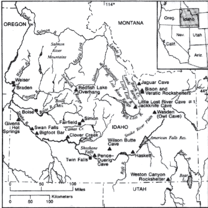 |
|
Figure 1. Map of Idaho region showing significant archaeological sites. Butler 1986:fig.1 |
Systematic archaeological research in southeastern Idaho began in 1958 with the advent of Earl Swanson's archaeological program at Idaho State University. At that time, highly stratified cave and rockshelter sites were selected for examination because they had potential for yielding a broad range of geological and biogeographical data essential for understanding human ecology on the Snake River Plain and in bordering upland regions. Other overriding concerns of this early work involved determining the antiquity of the Northern Shoshone in this area, clarifying the relationships between this region and the surrounding Great Basin, Plains, and Plateau cultural areas, and setting up a regional cultural sequence.
Swanson (1972) defined a series of local cultural phases marked by distinctive projectile point types, associations of faunal remains, and changes in natural deposition in stratified sites. Butler (1986) has grouped these phases into three broad cultural periods labeled Early Big Game Hunting, Archaic, and Late. This cultural sequence spans the last 14,000 years.
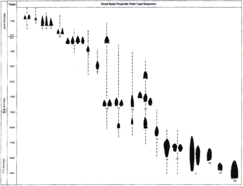 |
| Figure 2. Schematic of projectile point types. Jennings 1986:Fig.1. Click on the image for a larger version |
Early Big Game Hunting Period, ca. 14,000-7,800 B.P.
Cultural adaptations during this period are marked by a focus on hunting large game animals that became extinct during the terminal phase of Late
Pleistocene or in the early Holocene. Species taken included Mammuthus, B. Antiquus, Camelops, Equus, Ovis, Cervus, and Odocoileus. It is assumed that these peoples' diet also included plants and small game. Butler (1986:128) subdivides this period into three divisions based on the presence of distinctive projectile point types: Clovis, Folsom, Plano.
Clovis Subperiod, ca. 12,000-11,000 B.P.
Evidence of this period in the Upper Snake and Salmon River country is largely confined to surface sites lacking good stratified deposits. Some stratified sites like Jaguar Cave in southcentral Idaho have deposits radiocarbon dated to this period but lack diagnostic artifacts (Sadek-Kooros 1966). In general, surface finds have been without any associated patterning in cultural remains. Butler (1963) reported a unique Clovis find at the Simon Site northwest of Wilson Butte Cave. A number of Clovis points were found with 26-30 bifaces in this cache. Butler (1986:128) reports that Clovis materials were found during construction of fish ponds on the Snake River below Twin Falls.
Folsom Subperiod, ca. 11,000-10,600 B.P.
This period is found in one excavated stratified site and abundant widespread surface finds. Owl Cave (the Wasden Site) is a deeply stratified lava tube on the Snake River Plain (Butler 1978; Miller 1982). Radiocarbon dates on bone from a Folsom component ranged from about 12,850-10,920 B.P. Parts of four Folsom points were found in association with elephant, bison and camel remains. Isolated surface finds of Folsom points are common in this region.
Plano Subperiod, ca. 10,600-7,800 B.P.
This period is the most abundantly represented in this region, and is found in excavated contexts as well as surface finds. There is a fairly wide diversity of generalized lanceolate projectile point forms. Prehistoric economy seems to have been geared toward hunting bison at lower elevations, and mountain sheep in higher zones (Swanson 1972: Table 18). Remarkable Late Plano period kills of B. antiquus ca. 8000 B.P. were preserved at Owl Cave. These include the skeletons of more than 70 bulls, cows, and calves of different ages (Butler, Gildersleeve and Sommers 1971). It seems that two separate kills were involved: one before calving season and one just after. Butler (1978) reports that a single bison nasal bone flesher and about 30 projectile points comprise the recovered tool kit. Two of the points were reworked bases of Birch Creek series lanceolate points, indicative of the earliest occupations at Veratic Rockshelter in the Birch Creek Valley (Butler 1978; Swanson 1972)
Archaic Period, ca. 7800-1300 B.P.
Shortly after about 8000 B.P., the lanceolate point types characteristic of the preceding Plano Period were replaced by Bitterroot or Northern Side-notched points and stemmed-indented base points. As defined by Willey and Phillips (1958), the Archaic Period is the stage in North American prehistory characterised by generalized hunting-and-gathering economies in physical environments basically similar to those of today. Hunters took modern forms of bison, mountain sheep, deer, and small game. Plant resources were an important, dominant part of the diet. It is assumed that the atlatl and dart weapon system enters the archaeological record during the Archaic Period, and that this is reflected in the smaller and more variable types of projectile point types.
The stemmed-indented base point type appears to be older than the Northern Side-notched. It is found in deposits immediately overlying the Late Plano occupation at Owl Cave (the Wasden Site), and radiocarbon dated at about 7750 B.P. Stemmed-indented base points were also recovered from occupations at Wilson Butte Cave radiocarbon dated at 6890 B.P. Northern Side-notched points enter the sequence at Wilson Butte Cave in deposits dated about 6500 B.P. (Gruhn 1961). At Veratic Rockshelter in the Birch Creek Valley, Northern Side-notched points are found in strata thought to have dated about 8200 B.P. and continue on in the record to about 3450 B.P. (Swanson 1972). An excellent stratigraphic context is preserved for Northern Side-notched points at the Jimmy Olsen Rockshelter, where characteristic Northern Side-notched points were found in multiple activity surfaces lying just above redeposited layers of what is thought to be Mazama Ash. The bottom two strata have been radiocarbon dated at about 5420 B.P. and 5300 B.P. (Lohse 1991; Beta Analytic 43627 and 43626). Similar sequences have been recorded at Weston Canyon Rockshelter, southern Idaho, where stemmed-indented base points mark the earliest occupation dated about 8000 B.P., are replaced later by Northern Side-notched points from about 7800-5500 B.P., and then Humboldt Concave Base points after 5500 B.P. (Miller 1972).
The "Western Idaho Burial Complex" is distinctive pattern of burial marking the Archaic Period (Pavesic 1983). The best known site is the Braden burial site near Weiser, ID (Butler 1980; Harten 1980). Large bifaces, some of the "Turkey-tail type" with very low side notches, large corner-notched points, large side-notched points, obsidian preforms, and red ochre were found as characteristic burial associations. This complex is thought to date about 6000-4000 B.P. Similar point types have been found in southeastern Idaho, but without the obvious burial context.
The earliest use of subterranean dwellings is found at the Givens Hot Springs site on the Snake River in southwestern Idaho, dated at least 4300 B.P. (Green 1982). The houses are 6-8 meters in diameter, have floors over 1 meter in depth, and multiple roof support posts. Northern Side-notched and Humboldt Concave base projectile points were found in association with hopper mortar bases on the house floors. Later house floors have Elko point types in association with hopper mortar bases. Occupations appear to have been during the winter months, and the inhabitants ate deer, rabbits, and river mussels (Gonidea angulata). Dwelling sites appear to have been small during this time, consisting of two or three houses at locations scattered up and down the Snake River and its tributaries.
Reed et al. (1986) have divided the Archaic Period into three subperiods: an Early Archaic (7500-500 B.P.), marked by use of Northern Side-notched type projectile points and the large bifurcate or stemmed-indented base projectile points also labeled Pinto series; a Middle Archaic period (5000-3500 B.P.), marked by a proliferation of projectile point types rather than any one point type but including McKean like lanceolate and stemmed points, Elko series points, and Humboldt series points; and a Late Archaic (3500-1300 B.P.), marked by a number of projectile point types including Pelican Lake points, Besant points, and Elko series points.
The Archaic is characterised by an Altithermal climatic shift toward warmer and drier conditions, which Reed et al. (1986:110) suggest prompted bison hunting populations of the Plains to enter the upper Snake River Basin and begin hunting mountain sheep as well as bison. Certainly, as defined by Willey and Phillips (1958), the Archaic in this region documents a highly diversified subsistence. Butler (1978) argues that as the Altithermal reached its maximum about 3800 B.P., grasses essential to large bison herds began to fail, and bison hunting populations must have experienced some dietary stress than could be expected to prompt changes in subsistence strategy. As documented by Green's (1982) work at the Givens Hot Spring site our earliest evidence of the use of housepits is roughly coincident with the proposed Altithermal maximum as well, and is fully characteristic of significant changes in human adaptive strategy emerging during the Archaic period on the Snake River drainage.
Late Period, ca. 1300-150 B.P.
The Late Period is better known than any of the preceding periods in regional prehistory, and most likely represents prehistoric and protohistoric Shoshoneans occupying the Upper Snake and Salmon River country. Two cultural hallmarks are indicative of this period: Shoshonean Intermountain Ware pottery tradition and use of the bow and arrow.
A radiocarbon date from Dagger Falls on the middle fork of the Salmon River for Intermountain Ware pottery fragments places the earliest known use of pottery at about 2010 B.P. (Torgler n.d.). The temper of these sherds is crushed andesite, basalt, and quartzite in composition, most like sherd profiles for Thomas Shelter, Sudden Shelter, and Danger Cave in Utah (Dean 1988, 1991a, 1991b). Fremont pot sherds were also found in these same levels. Distinctions between Shoshonean and Fremont pottery traditions have been difficult to draw in the past. Butler (1983, 1986) has argued that pottery found in southeastern Idaho has often been misidentified as Shoshonean when in fact it is Fremont. It now appears that Fremont pottery types are rarely found in our region, and that the finer Shoshonean wares are similar to Fremont types in surface finish, temper, and rim curvature.
The Late Prehistoric Period is marked by a range of small triangular projectile point types. Corner-notched Rosegate series points extend throughout the period, as do Desert Side-notched series, and Cottonwood triangular points.
Ahvish Phase: The "Ahvish" Phase has deen defined for demonstrably Numic or Shoshonean occupation at the Wahmuza site at Cedar Butte, on the Fort Hall Indian Reservation (Holmer 1986). "Ahvish" was chosen by the excavators because it translates in Shoshone as "people from long ago" (Jimenez 1986:227). The phase is suggested to range from about A.D.1300 to 1850 or the arrival of European trade goods in the archaeological record.
Cultural diagnostics include Desert Side-notched and Rosegate series projectile points and grey-ware pottery. Two vessel forms have been identified: a crude flat-bottomed conical pot with coarse surface finish and coarse temper typical of the Shoshonean or Intermountain Ware Tradition, and finely finished globular bowls with fine temper.
Comparable Shoshonean cultural materials have been found in the Dietrich Phase occupation at Wilson Butte Cave, a lava blister on the Snake River Plain in northeast Jerome County, ID (Gruhn 1961). Dietrich Phase materials comprise the uppermost stratigraphic layer radiocarbon dated to about A.D. 1535. Projectile point types included Rosegate series, Desert Side-notched and Cottonwood triangular. Twelve pottery sherds were termed "Wilson Butte Plain Ware" by Gruhn, and are now considered to be representative of Shoshonean Intermountain Ware (Jimenez 1986:229).
Diagnostic Shoshonean materials were also identified in the Lemhi Phase defined by Swanson et al. (1964) for the Birch Creek Valley of eastern Idaho. This was described as part of the Bitterroot Cultural pattern, and based largely on excavation at Bison Rockshelter. The phase is dated at about A.D. 1250-1850. Diagnostic projectile point types are Desert Side-notched and Cottonwood triangular. Grey ware sherds were found at another rockshelter in the Birch Creek Valley, 10-CL-100, and are considered diagnostic of the Lemhi Phase.
Other excavated sites with late Shoshonean components include Polly's Place (10-LH-44), a rockshelter in Meadow Canyon, Birch Creek Valley (Ranere 1971); Jackknife Cave (10-BT-46), southern end of the Lemhi Range overlooking the Snake River Plain (Swanson and Sneed 1971); Meadow Creek (10-BV-22) and Willow Creek (10-BV-32) rockshelters in the Willow Creek Canyon of southeastern Idaho (Powers 1969); Poison Creek (10-BM-50), a large open site on Wilson Creek at the north end of Blackfoot Reservoir (Miss 1974); the Meacham Site, a rockshelter burial in the Snake Rive Canyon above Shoshone Falls; Pence-Duerig Cave (10-JE-4), a large deep alcove in the basalt rim of the Snake River Canyon northeast of Twin Falls (Gruhn 1961); site 10-AA-15, a rockshelter in the Snake River Canyon below Swan Falls Dam in southwestern Idaho (Tuohy and Swanson 1960); the Monida Pass Tipi Ring Site (10-CL-85), an open site on a terrace overlooking the conlfuence of Beaver, Stoddard and Daisy Creeks south of the Continental Divide in eastern Idaho (Ranere et al. 1969); the Challis Bison Jump (10-CR-196), a multicomponent site at the base of the Salmon River Mountains overlooking the Salmon River south of Challis (Butler 1971); and Aviators' Cave (10-BT-1582), a collapsed lava tube on the Snake River Plain, National Engineering Laboratory, southeastern Idaho (Lohse 1990; Lohse 1991).
Aviators' Cave is a unique site with phenomenal preservation of perishable materials. Analysis has not been completed, but stratified deposits reveal an upper activity surface with Desert Side-notched Sierra subtype, general Desert Side-notched, and Cottonwood triangular projectile point types, and finely finished, fine-tempered grey ware pottery of the Shoshonean Intermountain Ware Tradition. The artifact inventory is typical of the Ahvish Phase, and includes feathers, hair, fur, hide, and seed and other plant parts absent from the Wahmuza site. Identification of these items to species level should supply dramatic insights into Shoshonean subsistence strategies in southeastern Idaho in the late prehistoric or protohistoric period.
Protohistoric and Historic Shoshone Period
The transition from protohistoric to historic Shoshonean groups, which hinges on finding European trade goods in association with aboriginal materials, has not been well demonstrated in the archaeological record of this region. Some time after about 300 B.P. or during the Ahvish Phase horses came to the Shoshone and other Plateau tribes. At about the same time, trade goods of metal and glass were passing north in trade from the Spanish Southwest. To date, no professionally excavated stratified site with early European trade goods in definitive association with aboriginal Shoshonean assemblages has been recorded.
The boundary between protohistoric and historic periods for Shoshone has been arbitrarily set at the year 1805, when the first written records of the Upper Snake River Basin were produced by Lewis and Clark (Reed et al. 1986:114).
Prehistoric Site Types
Reed et al. (1986) have identified classes of archaeological site types for the Idaho National Engineering Laboratory grounds.
Residential bases.
These sites contain artifacts indicative of processing of multiple natural resources and stays of fairly long duration. They may contain evidence of dwellings, storage facilities, hearths, and a broad artifact inventory including non-portable items like heavy grinding stones and pottery, and variable small tool types from projectile points to simple utilized flakes. Site stratigraphy can be predicted to be patterned and relatively complex in both vertical and horizontal dimensions. These sites should be situated within short distance of multiple overlapping resource arrays including access to water, firewood, sheltered location, and high density clusters of plant and animal resources.
Field camps.
These sites may or may not contain smaller scale artifact assemblages comparable to those predicted for residential bases. Field camps are defined as being on a smaller scale than the residential bases, as having fewer people involved generally and perhaps reflecting more specialized activities. These sites will most often reflect extraction of single rather than multiple resources. They will include hunting camps where game was butchered and lightly processed, seed-gathering camps where plant parts were reduced and processed for easy transport, and good fishing locations where fish might be filleted and dried for hauling back to a residential base. Field camps will have less patterned site structure with fewer instances of elaborate cultural features beyond simple hearths. Recurrent visits will tend to make occupations difficult to define, and will result in dense artifact concentrations with little pronounced clustering reflecting temporal or functional differences in the assemblage. These sites should be situated within fairly direct proximity to the resources being tapped, often with less concern for access of water, firewood, or sheltered location.
Procurement locations.
These sites will contain evidence of focused extraction of a single important resource, and should not reflect stays of any duration. There will be no evidence of processing beyond that required for immediate extraction and transport to a field camp, and no evidence of camping activity reflected in features like hearths. Quarry areas for procurement of stone to work into tools and hunting sites exemplified in broken projectile points and light contained scatters of simple expedient tools like utilized flakes will dominate this site type. It is expected that plant extraction sites and fishing sites will be hard to recognize simply because the artifact inventory to procure these resources is highly perishable and suffers little loss in the extractive process. These sites should be located on the resource being extracted with no concern at all for water, firewood, or shelter, except as these may coincide with the distribution of natural resource arrays.
Caches.
Cache sites are defined as isolated storage locales for significant raw and finished resources. They may not be in direct association with any other site type. These sites may consist of patterned cultural features like prepared holes or cists, or they may be simply natural features like crevices or small overhangs in rock walls. Cultural context supplied in the limited overt patterning of these sites can be invaluable, since it represents discrete prehistoric or historic activity with cultural materials preserved in meaningful temporal and functional association. Artifact assemblages will characteristically show little variability within each cache, but the range across cache sites could show a broad range of economic and social or ideological activities. Encounter of these sites can be judged to be infrequent given their small size and prehistoric and historic efforts to obscure their location. Eroded banks along the reservoir and rock faces or areas of large tumbled stone should be routinely scoured for these types of features.
Stations.
These sites are defined as information gathering and information transmittal locations like vantage points, cairns, or rock art faces. Portable artifacts may be found and some evidence of camping might be observed, but in general, these sites will be lightly marked by artifact associations and will tend to have obvious correlates with landscape characteristics.
All of these site types may be encountered in archaeological surveys in southeastern Idaho.
Most sites in the residential base or field camp category would have been located where multiple resource arrays emerged. Sources of water, firewood, and sheltered locations will tend to cluster where rivers and streams bend, slow, widen out, or where small to large side streams or drainages feed into main channels, or where constrictions or geological features have altered the river and stream courses. The variables described above would also have enticed historic European activities to overlap with Native American activities. Often, sites selected for homesteads, towns, fishing, grazing, or hunting are those selected for in the past by prehistoric peoples.
To date, there has been little effective, systematic archaeological survey of any significant topographic features on or near the Snake River Plain other than intensive survey work done on the Idaho National Engineering Laboratory. The natural environment on the INEL consists of a relatively flat, unbroken volcanic landscape overlain by dunes and flanked by high buttes. Collapsed lava tubes and restricted riparian zones associated with seasonally inundated playas dot the landscape. Prehistoric human activity was channeled by the natural landscape, and therefore limited in scale and scope.
Other major productive resource zones on or associated with the Snake River Plain include the major river drainages and the surrounding mountain masses. Neither major topographic feature has been systematically surveyed for archaeological resources. Swanson's (1972) work in the Birch Creek Valley was limited to understanding geological deposition, environmental change, and cultural chronology. Holmer's (1986) work at Wahmuza in the Fort Hall Bottoms along the Snake River, is invaluable because it sampled a resource environment heretofore untapped, but the work was seriously limited by restrictions put on survey of larger sections of the bottoms along the river and dunes and terraces away from the river or drainages flowing into the Snake.
Any major riverine resource area should produce a variety of prehistoric hunting, fishing, plant gathering, and residential sites of some scale and complexity. The prehistoric record for southeastern Idaho is a relative uknown in this regard simply due to the selective restrictions of past research. The ethnohistoric and ethnographic records offer some tantalizing clues on how Shoshonean peoples used the river or related to it, but to date we have had little opportunity to explore these relationships in any detail. The historical record of early exploration and contact offers some very biased yet invaluable descriptions of Shoshoneans using the riverine environments, describing large camps down on the Snake River, with Shoshone taking fish, gathering plants, and hunting (Clark 1986). The record of early trappers and explorers has also created the opportunity for historical archaeology focused on finding sites of this early historic activity. We know that the Astorians were the first to traverse the Snake River, and that they had multiple accidents, canoe turn-overs, and camp sites along the river. Later trappers were known to have exploited resources along the Snake, and immigrants travelling down the Oregon Trail touched upon the river environments. Still later, early farms and ranches were placed in sheltered, watered locations on the river. So, the riverine environments were an attraction for both prehistoric and historic populations.
Historical Record
The first written description of Shoshone peoples resident in Idaho appears in the journals of Lewis and Clark (1805-1806), with their encounter of Shoshone on the Lemhi River in northeastern Idaho. Fur companies lost little time in exploiting the region. In 1808-1810, Canadian fur trader David Thompson visited the Kutenai, Pend d'Oreille, and Coeur d'Alene of northern Idaho. Washington Irving compiled records of the Astoria party who travelled down the Snake River in 1811-1812. The journals of Peter Skene Ogden, chief trader of the Hudson's Bay Company, for 1825-1828, describe lives of Shoshone on the Snake River. Captain Bonneville's journal for this expedition in 1832-1834 supplies insight into the lives of the Indians of the region. Other accounts include written records of fur traders Nathaniel Wyeth and Osborne Russell, and clergyman Samuel Parker..
Fur Trade Period, ca. 1808-1842.
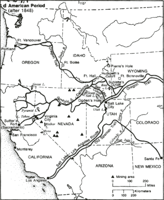 |
| Figure 3. Historical map of the Northern Intermountain West. Malouf and Findlay 1986:Fig.1d. Click on the image for a larger version |
Direct impact on aboriginal societies during this early phase of contact in this area was slight, but developments were taking place that would have dramatic impacts on Shoshonean and other Idaho groups (Lohse 1991). The first permanent fur trading establishment was Fort Henry, built by the Missouri Fur Company on the North Fork of the Snake River in the fall of 1810. In the fall of 1811, the Wilson Price Hunt Expedition or "Overland Astorians" encountered a Shoshone camp near the confluence of the Portneuf and Snake Rivers or near the present day "bottoms" on the Fort Hall Indian Reservation. This same expedition continued down the Snake River, making a successful portage at American Falls. Travel down the river beyond that point was dangerous, and there are numerous accounts of goods lost in capsizings of canoes. Finally, some distance down from "Devil's Scuttle Hole" the party broke up, leaving behind sixteen caches of goods (Beal and Welles 1959:101). The Hunt party was to reach Astoria, and then return back along the route they had pioneered. In fact, the route discovered and explored by the Overland and Returning Astorians was to become the Oregon Trail, a travel route for tens of thousands of American settlers headed for California and Oregon Territory.
Although the Astorians' venture had proven abortive, and their post at Astoria on the mouth of the Columbia River was sold to the Canadian North West Fur Company on November 12, 1813, they had established a link for the Upper Snake and Salmon River country to the Columbia River drainage and the Pacific Northwest that was never broken. Early American fur companies in this region had difficulty maintaining the extenuated lines of supply that came up the Missouri River system into the Intermountain West. Canadian and British companies on the other hand, began to establish posts on the Columbia River system that were to dominate trade in this region for the next half-century.
Donald Mackenzie was assigned to head the newly created North West Company's interior department of the Columbia in June, 1816. An unusual leader, full of energy, and knowledgable of Indian societies, Mackenzie was to dominate the trade in the Snake River country in ensuing years. It was his expressed goal to expand North West Company fur trading operations up the Snake River drainage into what is now Idaho. Staging operations out of Fort George (Astoria), Mackenzie led fur brigades up the Snake River in 1816-1817 and up the lower Snake in 1817-1818. Fort Nez Perce, established in July, 1818, became the staging point for Mackenzies' Snake brigades. The expedition of 1818-1819 brought Mackenzie and a large brigade across the Blue Mountains, down the Snake River on to the Bear River, and to the headwaters of the Snake. On his return, he came back to the Boise, and described how rich the region was in furs. He was prompted to establish a navigable route up the Snake RIver from Fort Nez Perce to the Boise area in 1819. Mackenzie did succeed in ascending in a boat from the Columbia through the Grand Canyon of the Snake past Hells Canyon, though he concluded that land transport was probably safest.
Mackenzie held the first rendezvous in the region on the Boise River in 1819. William Kittson was dispatched up the Columbia with a large party and supplies to outfit the Snake country fur brigades. Kittson then hauled the Snake brigades furs back to Fort Nez Perce, and reported success of the expeditions at Fort George. Shoshone hostility, however, ruled out construction of the fur trading post Mackenzie envisioned on the Boise. Mackenzie spent the winter of 1819-1820 on the Little Lost River.
On April 6, 1821, the North West Company joined with the Hudson's Bay Company. Donald Mackenzie was appointed chief factor and left the Snake River country for the Red River in Canada. The furs of the Snake River country were never taken in quantity again, and it seems that the Hudson's Bay Company viewed the Columbia River and Snake RIver drainages of the Pacific Northwest largely as a buffer against Russian and American expansion. They intended to hold on to the Oregon country as long as possible and ensure continued control of the profitable New Caledonia or British Columbia trading area.
Two St. Louis fur companies sent expeditions to the Rocky Mountains in 1822 that attracted Hudson's Bay Company attention. The Ashley-Henry Rocky Mountain expedition reached this region in 1824, and prompted Alexander Kennedy at Spokane House to revitalize the Snake brigade. Two Snake brigade expeditions traveled past Flathead House and the Bitterroot to the upper Missouri, returning south by way of the Lemhi to Henry's Fork, the Blackfoot, and down the Green or Bear River in one instance. Hostilities with Blackfoot bands were marked, and in all, trapping and trade were not intensely profitable for the British or American companies. Several years brought relative peace for the HBC brigades in working their way through Indian territory, but by 1824, Rocky Mountain Fur Company trappers were on the Salmon. This marked the date of contest between British and American companies for the furs of the Snake country.
President James Monroe's doctrine initiated in his message to Congress in 1823 had clearly indicated the United States' interest in expanding into the Oregon country. The London directors of the Hudson's Bay Company instructed Governor George Simpson to control the Snake country as an effective boundary to American economic encroachment. It was the expressed interest of the company to extract furs as quickly as possible, and that the resources of the Snake country which probably could not be kept by the HBC should not be conserved.
Rocky Mountain Fur Company expeditions were on the Portneuf and Bear Rivers in 1824. Perceived American threat on the Snake country led to Peter Skene Ogden's appointment to head the Snake brigades. Establishment of Fort Vancouver on the lower Columbia River and replacement of Spokane House by Fort Colville near Kettle Falls were HBC attempts to create greater self-sufficiency for the Columbia River operations. It was Ogden's explicit object to leave the Snake country barren of fur and unattractive to American fur companies. Ogden's fur brigade left Spokane House in December of 1824 in cooperation with Jedediah Smith and his Rocky Mountain Fur Company trappers. These men trapped southeastern Idaho with fair success throughout 1825. Ogden was to find his brigade unreliable and willing to go over to American interests. Jedediah Smith reported that his 1824 and 1826 expeditions had shown profitable resources still left in the Snake country. Review of Ogden's work was less favorable, and the HBC concluded that little fur was left south of the Snake River.
Agreement between the United States and Great Britain on August 6, 1827, to continue the Oregon boundary convention of 1818 for an indefinite period left exploitation of the Oregon country by Americans open. By his fourth expedition in 1827, Ogden found American trappers throughout the country surrounding Boise. Fur quantities were down, but American and British contingents continued to worked the country. Ogden spent the winter of 1827 on the Portneuf. Fur hunts of 1828 faced increased depredations by Blackfoot and Shoshone, increasingly disatisfied with European presence in their territories. When Ogden left the area in 1828, work by British and American companies had seriously diminished the fur resources of the Snake country.
By 1830, neither the HBC nor the American companies were in control of the Snake country. Depredations by Blackfoot and Shoshone and low returns on furs discouraged further intensive work. Yet, an American Fur Company expedition and another Snake brigade under the direction of John Work were in the region again in the fall of 1830. Work's brigade scoured the Weiser, Payette, and Boise country thoroughly. Work went up the Lost River to the Salmon, and over to the Blackfoot and onto the Portneuf to winter. Throughout, the brigade extracted little fur. Work's men worked the mountainous country of central Idaho, and scoured the fur devastated country for what little might remain.
American companies continued to work around and in the Snake country. Expeditions led by Walker and Bonneville met in 1834, and concluded that British domination of what little remained in the Snake country was secure. The Rocky Mountain Fur Company dissolved in 1834, and the American Fur Company was left in control of the St. Louis based trade. In 1834, Nathaniel Wyeth, disatisified with his fur trade venture, established Fort Hall to dispose of goods rejected at the 1834 rendezvous. As the fur trade was unprofitable, Wyeth thought he might trade with the Indians and recover some of his expenses.
The original Fort Hall was located on the south bank of the Snake River above the mouth of the Portneuf. It was sixty feet square with ten foot high walls and interior rooms of poles thatched with brush and covered with clay. Shortly after the fort was established, it was visited by a large band of Shoshone and Bannock numbering at least 250 lodges. One July 27, 1834, a group of Nez Perce and Cayuse attended Methodist minister Jason Lee's services at the fort with a Hudson's Bay Company fur brigade. The fort continued to be a focus for Shoshone-Bannock tribes over the next twenty-three years.
Trade at the fort worried Hudson's Bay Company officials enough that brigade leader Thomas McKay established Fort Boise near the mouth of the Boise River in 1836. The HBC hoped that Fort Boise would stop any flow of furs from tribes further northwest down to Fort Hall. In 1837, the HBC solved any competition problem by buying Fort Hall. HBC Fort Hall dominated fur traffic in Rocky Mountains for the next twenty years. It also became a primary stopover and supply point for immigrants on the Oregon Trail. The California Gold Rush of 1849 brought thousands of settlers past the fort. Its location above the split off between trails to Oregon and California made the fort a focus of promoters trying to attract settlers to one region or the other. The Hudson's Bay Company closed Fort Hall with the onset of hostilities in the Yakima country in 1855 that closed Fort Walla Walla and threatened lines of supply to the Snake country.
Oregon Trail and Westward Migration, ca. 1842.
Organized migrations to the Oregon Territory began by 1842, prompted in no small part by earlier missions that had set up small agricultural communities in the Pacific Northwest. Oregon missionaries actively encouraged colonization by United States citizens to offset British interests in the region. In 1846, a treaty between the United States and Britain gave all the land west of the Rocky Mountains to the Pacific Coast and between the 42nd and 49th parallels to the United States, with exceptions of holdings of the Hudson's Bay Company and the Puget Sound Agricultural Company which might be purchased at some future date. These holdings were purchased by the United States in 1863.
Immigrants began using the Oregon trail in large numbers in 1842, when Dr. Elijah White led an expedition of over one hundred people over the rough wagon road to Oregon's Willamette Valley. In 1843, a thousand emigrants crossed the trail in Applegate's wagon train. The trail had received U.S. government recognition with Charles C. Fremont's survey of 1842-43, which demonstrated that the Columbia River drainage provided the only practicable route across the Rocky Mountains to the Pacific Ocean. A dramatic increase in immigrant use of the trail occurred starting in 1848 and 1849. Many were headed for the gold fields in California, many to the rich arable land of the interior valleys of Oregon. This was the period of greatest impact on the Indian societies of the region. Permanent settlements in Idaho would be relatively rare for several decades yet, but effects of fur trading activities and contact with migrating settlers were dramatic.
Effects of European Contact on Shoshone and Bannock Tribes.
The Shoshone or "Snake" were, of course, known outside of present-day Idaho prior to Lewis and Clark's exploration. Thompson (1916) records the Snake as a populous and powerful foe on the Western Plains. Their might in the early 18th century inhibited the expansion of Siouan groups which were being forced west by European advance. Earlier, probably sometime in the 16th century, Shoshoneans had expanded well down into Texas and New Mexico. These Utes and Comanches were Plains tribes dependent upon buffalo for their existence (Forbes 1959; Tyler 1951; Shimkin 1986). In pre-gun times, the early 18th century, it seems that the Shoshone were using a sizable portion of the western Plains. Teit (1930:303-305) relates Flathead and Nez Perce traditions that place large Shoshone bands on the Upper Yellowstone River east of the Bighorn Mountains and along the Upper Missouri River. Apparently, it was smallpox in the late 1700s that first threw the balance of power to the Shoshone's enemies. These epidemics resulted in dramatic population losses, and combined with better armed adversaries expanding onto the western Plains, effectively pushed the Shoshone back into the Rockies (Thwaites 1904-1905, 2: 373). By 1804, when visited by Lewis and Clark, the Shoshoneans were only cautiously venturing out onto the Plains to hunt buffalo. Even their territories in the Rocky Mountain area were not entirely safe, however, and incursions by Blackfeet and others were common.
Shoshone fighting to retain control of their territories was a constant theme throughout the early 19th century. Better armed Blackfeet and Siouan adversaries were constantly encroaching on Shoshone land. Flathead and other Salishan groups to the north often found common cause with the Shoshone, and it was not uncommon to find mixed bands of buffalo hunters or trading parties made up of members of these mountain groups.
Buffalo were not the only lure for Shoshone to continue using the Plains. Long-time trading relationships had been established between Shoshone and other horse breeding tribes of the Rocky Mountains and the Siouan agriculturalists along the lower Missouri River in present-day Nebraska and South Dakota. Trading fairs were held annually between Shoshone and Crow and Hidatsa and Mandan at the latters' villages on the Missouri. Larocque (Burpee 1910:22-37) found Shoshone and Crow at the Mandan villages in 1805. Shoshonean horses formed the basis of a trade conduit that brought hides and other mountain products to the Missouri villagers in exchange for garden produce and other goods. Shoshone were also on the Southern Plains for trade. Jacob Fowler found Shoshones with Comanches at a large trading rendezvous on the upper Arkansas in 1826 (Coues 1898:51-54).
By the late 18th and early 19th centuries, this access to trade was imperiled by encursions of populous non-agricultural Sioux, and Shoshone and other mountain groups found it increasingly dangerous to travel on the Plains except in large groups. The Crow became middlemen and maintained trading relationships with the Hidatsa and Mandan villages, until these too were destroyed by epidemics and relentless Sioux pressure.
European politics and economics obviously conditioned this ebb and flow of Native American interaction in the 18th and 19th centuries. It was European advance that forced the Siouan groups out onto the Plains from the western Woodlands around the Great Lakes. It was industrial age European technology that brought firearms in large numbers to Siouan and Athapascan adversaries of the Shoshone. It was economic interest in furs that initially brought the European market economy out onto the western Plains and Rocky Mountain regions looking for Native American producers and consumers.
The colorful era of the fur trade was expansion of the European market economy (Lohse 1988). Native American groups became suppliers for European entrepeneurs opening new markets predicated on furs. Other elements were traded, such as horses, hides, women, and children, but furs can be seen as the primary motivating force attracting so much European attention in the mid-19th century and before.
The Shoshoneans and the Crow were friendly partners for the European fur traders. This was not a philosophical position so much as a purely pragmatic one. The Crow and Shoshone by the 19th century were in a besieged, marginal position. They had horses but they needed firearms to duel successfully with Blackfeet, Arapaho, Cheyenne and Sioux. It was important for them to form trading alliances with representatives of Industrial Age European societies. The Blackfeet and Sioux had proved troublesome for American traders, and they welcomed the relatively warm reception provided by the Crow, Shoshone, and other mountain tribes. The British too found the mountain tribes hospitable, and the Hudson Bay Company fur brigades operating in the Pacific Northwest worked in relative peace. The Shoshone, like the Flathead and Nez Perce, did not gather many furs. These tribes provided horses and supplies to the HBC brigades. They also supplied some measure of protection by standing between potentially hostile Athapascan and Siouan tribes and the European economic markets. The mountain tribes needed firearms and support from European traders and in return gave support and a covering umbrella of protection for trading operations.
Competition between fur companies resulted in removal of the beaver from the watershed. European hunting parties not only depleted the sought after furs but also eliminated aboriginal food resources. Charles Preuss, cartographer for John C. Fremont, in 1843 observed that "the white people have ruined the country of the Snake Indians and therefore should treat them well. Almost all the natives are now obliged to live on roots, game can scarcely be seen any more" (Gudde and Gudde 1958:86).
By 1840, the fur trade and the buffalo were all but gone from the Shoshone and Bannock country. Interaction with the traders throughout the early 19th century had produced a number of changes in Shoshonean society. Rendezvous or trading fairs, just as in aboriginal times, brought together large numbers of people representing many different mountain tribes as well as Europeans and their allies. An encampment would contain Shoshone, Bannock, Flathead, and Nez Perce, as well as British, French and American traders, and Iroquois and other Native Americans working with the fur brigades. Out of these associations, came marriages between Europeans and Shoshone, and Shoshone and other tribes. Often, these were economic arrangements as well as affairs of the heart. Marriage of a daughter to a trader brought access to European goods. It also brought security since in times of stress a trader could be counted on to support his Shoshone family. Working with the traders also produced sought after firearms, as well as other seductive items of European manufacture like metal pots and pans to replace baskets and pottery, glass beads to replace bone and shell ornaments, metal sewing awls to replace bone splinters, thread and cloth to replace sinew and hide clothing. Brigham Madsen (1980:23, 25) argues that limited Northern Shoshone contact with fur traders brought about a short-lived "cultural golden age" by adding new elements to their way of life, without seriously disrupting their traditional patterns.
Close association with Europeans also produced disasterous changes: disease that decimated aboriginal populations that had no immunity; prostitution of women for access to goods and security; breakdown of traditional tribal sociopolitical organization as intermarriage and economic pressures disrupted old systems. Shoshonean interest in interaction with Europeans was partly pragmatic, a desire to introduce security against hostile encroachments by more populous better armed tribes. Industrial Age technology was an attraction in itself: metal is more durable than stone or pottery; cloth offers more possibilities for clothing than hide; dyes and glass and other esthetic productions offer greater varieties of artistic expression than limited selections of natural dyes and other unmodified products of nature.
It was in areas of the landscape where aboriginal populations concentrated, and where European economic interests coincided, that Native Americans suffered most. Anglo-American attention to "desert oases," well-watered riverine environments, undermined the fragile desert ecology and disrupted aboriginal economies. Native Americans in these areas often responded by stealing traps and raiding herds of livestock. The Fort Hall Bottoms were just such a sensitive riverine resource zone, rich in vegetation and animal species of utmost importance to Shoshone and Bannock economy.
Fort Hall was founded in this period of social and political flux for Shoshonean societies. The post was established in the river bottoms, now referred to as the Fort Hall bottoms. The bottoms held marshes with attendant wildlife, deer, and feed for the large Shoshone horse herds. They were the scene of winter camps and get-togethers. Placing the fort in the bottoms simply amplified the importance of the area, and intensified Anglo-American and Shoshone-Bannock interaction.
The name was carried over with the U.S. Army's construction of a fort on Lincoln Creek in 1870, some twenty miles to the northeast of the original Fort Hall site. This military post was abandoned shortly thereafter, and the name Fort Hall became applied to the Shoshone-Bannock Indian Reservation that encompassed the original "Fort Hall Bottoms" on the east side of the Snake River.
The end of autonomous life for the Shoshone and Bannock is found in the 1860s, with the disappearance of the buffalo and the beginnings of Mormon settlement in the Bear River Valley. Throughout the 1860s, settlers encroached on Shoshone and Bannock territory. Settlers entered the Boise River Valley. Gold miners entered the mountains. Increasing conflicts between Anglo-Americans and Native Americans led the United States government to pursue a policy of treaty making. Pacts were made at Fort Bridger, Box Elder and Soda Springs in 1863, and at Fort Boise in 1864.
The Fort Hall Reservation was established in 1867 for the Boise River and Bruneau River bands. In 1868, the Fort Bridger Treaty located the Fort Hall Shoshone and Bannock on the same reservation In 1907, the Lemhi and Sheepeater bands were removed to the Fort Hall Reservation as well.
The rich Fort Hall Bottoms had originally attracted Shoshone and Bannock bands. Construction of Fort Hall further concentrated both Native American and Anglo-American interest on the bottoms. The fur trade eventually dissipated, but Fort Hall continued to be used as a supply point for the thousands of settlers that passed through Idaho from the 1840s to the 1860s. Fort Hall and the bottoms then became the heart of the Fort Hall Indian Reservation. A rich panoply of Idaho history, recording the interaction of Indian and White societies, centers on Fort Hall and the surrounding bottoms, a story that is still not fully understood.
List of References
Beale, M.D. and M.W. Wells
1959 History of Idaho. New York: Lewis Historical Publishing Company, Inc. 2 volumes.
Burpee, L.J. (ed.)
1910 Journal of Larocque from the Assiniboine to the Yellowstone, 1805. Publication of the Canadian Archives No.3. Ottawa.
Butler, B.R.
1963 An early man site at Big Camas Prairie, south-central Idaho. Tebiwa 6:22-33.
Butler, B.R.
1971 A bison jump in the upper Salmon River valley of eastern Idaho. Tebiwa 14:4-32.
Butler, B.R.
1978 A guide to understanding Idaho archaeology. Upper Snake and Salmon River country. Special publication of the Idaho Museum of Natural History. Pocatello.
Butler, B.R.
1983 The quest for the historic Fremont and a guide to the prehistoric potterv of southern Idaho. Occasional Papers of the Idaho Museum of Natural History No.33.
Butler, B.R.
1986 Prehistory of the Snake and Salmon River Area. In "Great Basin," Warren L. d'Azevedo (ed.), pp.127-134. Handbook of North American Indians Vol.11, William C. Sturtevant (gen. ed.). Washington, D.C.: Smithsonian Institution.
Coues, E. (ed.)
1898 Jacob Fowler, narrating The ioumal of an adventure from Arkansas through the Indian territory ... 1821-22. New York: F.P. Harper.
Green, T.J.
1982 House form and variability at Givens Hot Springs, southwest Idaho. Idaho Archaeologist 6:33-44.
Gruhn, R.
1961 T'he archaeologv of Wilson Butte Cave, south central Idaho. Occasional Papers of the Idaho State College Museum No.6.
Gudde, E.G. and E.K. Gudde (eds. and trans.)
1958 Exploring with Fremont: The private diaries of Charles Preuss, cartographer for John C. Fremont on his first, second and fourth expeditions to the Far West. Norman: University of Oklahoma Press.
Holmer, R.N.
1986 Shoshone-Bannock culture history. Swanson/Crabtree Anthropological Research Laboratory, Reports of Investigations 85-16.
Jimenez, J.
1996 The Ahvish Phase at Wahmuza and the Numic Affiliation of the Dietrich and Lemhi phases of southern Idaho. Unpublished Master's thesis, Department of Anthropology, Idaho State University.
Lohse, E.S.
1990 Aviators' Cave. Idaho Archaeologist 12:23-28.
Lohse, E.S.
1991 Fort Hall and the Shoshone-Bannock. In Fort Hall and the Shoshone-Bannock in the pages of history, E.S. Lohse (ed.), pp.7-20. Rendezvous 26.
Lohse, E.S.
1994 The southeastern Idaho prehistoric sequence. Northwest Anthropological Research Notes 28(2):135-156.
Madsen, B.
1980 The Northern Shoshone. Caldwell: Caxton Printers.
Miss, C.J.
1974 Final report on the archaeology of the Blackfoot Reservoir, southeastern Idaho.
Pavesic, M.G.
1983 The Idaho burial complex; Abstracts of the papers, pp.34-36. Paper presented at the Thirty-sixth Annual Northwest Anthropological Conference, Boise, ID.
Powers, W.R.
1969 Archaeological excavations in Willow Creek Canyon, southeastern Idaho, 1966. Occasional Papers of the Idaho State University Museum No.25.
Ranere, A.J.
1971 Stratigraphv and tools from Meadow Canyon, southeastern Idaho. Occasional Papers of the Idaho State University Museum No.27.
Ranere, A.J. et al.
1969 The Monida Pass tipi ring site. Tebiwa 12: 39-46.
Reed, W.G. et al.
1986 Archaeological investigations on the Idaho National Engineering Laboratory, 1984-1985. Report to EG&G, Idaho, Earth and Life Sciences Division, Idaho Falls, Idaho.Swanson/Crabtree Anthropological Research Laboratory, Report of Investigations 86.
Sadek-Kooros, H.
1966 Jaguar Cave: An early man site in the Beaverhead Mountains of Idaho. Unpublished PhD dissertation, Harvard University.
Swanson, E.H.
1972 Birch Creek: Human ecology in the cool desert of the northern Rocky Mountains, 9000 B.C.-A.D. 1850. Pocatello: Idaho State University Press.
Swanson, E.H. and P.G. Sneed
1971 Jackknife Cave. Tebiwa 14:33-69.
Teit, J.A.
1930 The Salishan tribes of the western Plateau. In Franz Boas (ed.), 45th Annual Report of the Bureau of American Ethnology for the Years 19271928, pp.23-396. Washington, D.C.
Thompson, D.
1916 David Thompson's narrative of his explorations in western North America, 1784-1812. Joseph B. Tyrell (ed.). Publication of the Champlain Society 12.
Thwaites, Reuben Gold
1904 Original journals of the Lewis and Clark expedition, 1804-1806. 8 volumes. New York: Dodd, Mead and Company.
Willey, Gordon R. and Philip Phillips
1958 Method and theory in American archaeology. Chicago: University of Chicago Press.
The Wasden Site
The excavation at the Wasden site started in 1965 by the Upper Snake River Prehistoric Society (USRPS) under the direction of B. Robert Butler of the Idaho State College Museum, now the Idaho Museum of Natural History (Butler 1968b). The Wasden site proper consists of three proximal caves created by collapsed lava tubes. In the published literature "Wasden" is used interchangeably with Owl Cave to discuss the work done there. Of the three caves, Owl Cave (10BV30), Coyote Cave (10BV31), and Dry Cat Cave(10BV32), only Owl Cave has been extensively excavated. Coyote Cave received preliminary work, but because of heavy rock fall was never fully excavated. Dry cat cave received only initial testing. Starting late in 1965 work at Wasden consisted of limited pedestrian survey of the landscape surrounding Owl, Coyote, and Dry Cat caves. The amateur USRPS was the principal labor for the project, and as such most of the work could only occur on the weekends. Test excavations in Owl Cave were also started late in 1965. The excavations were carried out by the USRPS until 1971. Excavations were taken up by Idaho State University in 1974 under Susanne Miller. This work was the focus of a National Science Foundation grant (SOC75-10340) that was awarded to Earl Swanson, director of the Idaho State University Museum (now the Idaho Museum of Natural History). Later the analysis of the Wasden material continued with the funding of a further NSF grant (SOC77-16157), awarded to Wakefield Dort and Susanne Miller. The excavations of the site were continued in 1975, until 1977, under Susanne Miller and carried out by an Idaho State University field school with members of the Upper Snake River Prehistoric Society.
| Figure 5. Owl Cave opening looking into the cave. | 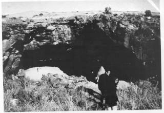 |
Figure 6. Owl Cave opening looking out of the cave. | 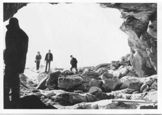 |
Owl cave consists of sporadic human occupations, however these sporadic occupations seem to consist of unique, discrete events that allow for greater understanding of prehistoric hunter-gather ecology. The events that received attention from early excavators were a dense bison bone bed, having over 6000 faunal elements, which has been roughly bracketed by radiocarbon dates between 7800 and 8200 BP (Butler 1968a, 1968b, 1971a, 1971b, 1974, 1975, 1978, 1986). Secondly, a mammoth kill, with a fluted point association, described as a workshop with extensively broken and modified bones from mammoth, bison, and camel (Miller 1982,1989; Butler 1986). Because of lack of funding or time, or perhaps because of the cultural-historical bent of the archaeology of the time, the artifacts were bagged and no analyses were carried out. Artifacts received cursory examination and were placed in a cultural-historical sequence for the two published layers.
Of the two published occupations at Owl Cave there are very limited artifactual assemblages. The Bison bone bed had 62 artifacts, including flakes, organic material, projectile points, and worked bone. Butler (1968b:12) describes most of the projectile points being similar Agate Basin points (c.f. Sharrock 1966:52), which are included in the Plano series (Lohse 1995:20-21). The mammoth kill layer has a fluted point association. These points, based on the time of the occupation, are assumed to be folsom (Miller 1982). However of the approximately 1600 artifacts recovered from Owl Cave, nearly the entire culture-historical sequence from Idaho has been found. The material culture of the past has specific biographies to be explored to tell us more about the past, or more accurately the specific way in which particular things were used in the past (Kopytoff 1986).
| Figure 7. Excavation of layer 17, "the Bison Bone Bed", from Butler 1968b, figure 10. | 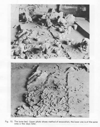 |
In the excavation at Wasden in 1965 the grid system was set up using two-meter excavation test units, with a North-South axis and an East-West axis. As such the grid system was labeled with a three character name, eastern side of the site carrying an "E" designation, western side of the site carrying a "W", followed by a number (x-axis) and a letter (y-axis). Most of the excavation took place in the eastern section of Owl Cave, at five centimeter arbitrary excavation levels. Although the unit that was selected for the recovery of microfauna, due to its location under ledge assumed to be used as a prehistoric owl roost (Guilday 1969:47), was screened in 10 centimeter arbitrary levels. The excavation used 3/8" screen. Later excavations used the same grid system, but using varied excavation levels and screen. The western part of the cave went unexcavated due to heavy rockfall uncovered less than meter below site surface (Butler 1968b:7).
| Figure 8. Excavation unit at Wasden. | 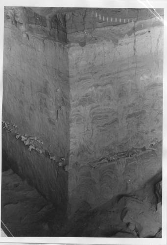 |
| Figure 7. Excavation of layer 17, "the Bison Bone Bed", from Butler 1968b, figure 10. | |
| Figure 34. Wasden grid, Butler 1968b figure 6. | 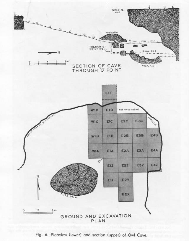 |
The stratigraphy of the Wasden site exceed six meters in depth, and are made up of finely stratified, hortizontally bedded loessial sediments (Butler 1968b:7). The strata held abundant microfauna, bird, and large faunal remains. Deposition consisted of fine laminae of wind blown and water deposited sediments broken up by periodic episodes of rock-fall caused by frost weathering of the laminar basalts constituting the walls and overhang.
| Figure 9. Stratigraphy of the Wasden Site, from Butler 1968b, figure 7. | 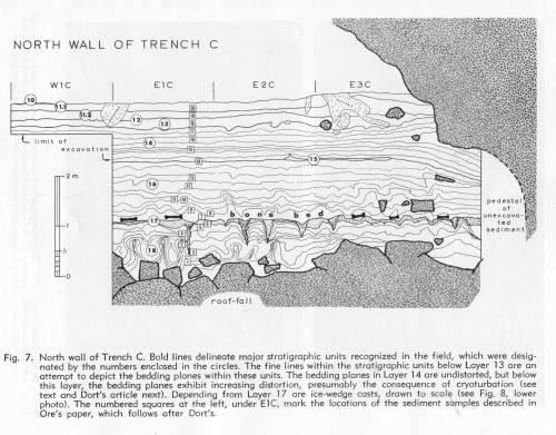 |
| Figure 10. The "c-trench" from the Wasden site, from Butler 1968b, figure 8. | 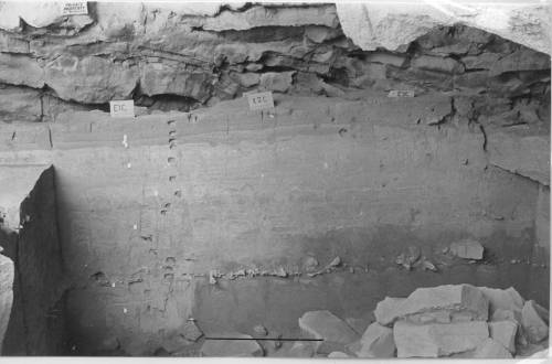 |
The Wasden site has been dated using thirteen radiocarbon, fourteen obsidian hydration, and the inclusion of redeposited Mt. Mazama ash (Butler 1968b:7). The Mazama ash gives a date of 6900 B.P. for layer 15 in the Owl Cave stratigraphy, which is roughly a meter below the surface of the site. Layer 17, the bison bone layer is from two to two and half meters below the surface. Radiocarbon dates bracket the layer between 7800 and 8200 B.P. (Butler 1968b:8, Dort 1968b:34). A series of radiocarbon (N=7) and obsidian hydration (N=14) dates frame the temporal sequence for the lower levels, from four and half to five and half meters, which Miller worked. The dates range from 10,000 to 12,000 B.P. (Plew and Pavesic 1982, Miller 1989, Dort and Miller 1977, Butler 1972).
Figure 11. Table of Radiocarbon and Obsidian Hydration dates from the Wasden site.
| Lab and #, or specimen # | Date | Material | Feature | Reference |
| WSU-561 | 3340±575 | Charcoal | Layer 13 | Butler 1968b: 7 |
| WSU-680 | "modern" | Unknown | Layer 14, Layer15 | Butler 1968b: 7 |
| WSU-641 | 7750±219 | Charcoal | Layer 16 | Butler 1968b: 8 |
| M-1853 | 7100±350 | Bone | Layer 16 | Butler 1968b: 8 |
| WSU-560 | 8160±260 | Bone, burned | Layer 18 | Butler 1968b: 8 |
| WSU-758 | *8000± | Bone | Layer 18 | Butler 1968b: 8 |
| WSU-2485 | 10145±170 | Bone | 4.52-4.54 m b.o.d. | Plew and Pavesic 1982 |
| WSU-2484 | 10470±100 | Bone | 4.70-4.80 m b.o.d. | Plew and Pavesic 1982 |
| 76465 | 11627±375 | Obsidian | 4.72-4.82 m b.o.d. | Miller 1989 |
| WSU-1259 | 12250±200 | Bone | 4.80-5.10 m b.o.d. | Butler 1971 |
| 76439 | 11938±499 | Obsidian | 5.05 m b.o.d. | Miller 1989 |
| 76439a | 11587±422 | Obsidian | 5.05 m b.o.d. | Miller 1989 |
| 76439b | 11657±494 | Obsidian | 5.05 m b.o.d. | Miller 1989 |
| WSU-2483 | *9735±115 | Bone | 5.10 m b.o.d. | Plew and Pavesic 1982 |
| WSU-1786 | 10910±150 | Bone | 5.09-5.14 m b.o.d. | Dort and Miller 1977 |
| 76438 | 11733±431 | Obsidian | 5.09 m b.o.d. | Miller 1989 |
| 76436 | 11424±206 | Obsidian | 5.12 m b.o.d. | Miller 1989 |
| D4 | 11206±315 | Obsidian | WS | Miller 1989 |
| D2 | 11627±267 | Obsidian | WS | Miller 1989 |
| 76394 | 12008±285 | Obsidian | 4.80 m b.o.d. | Miller 1989 |
| 76437 | 12293±435 | Obsidian | 5.19 m b.o.d. | Miller 1989 |
| D3 | 12078±215 | Obsidian | WS | Miller 1989 |
| D5 | 12151±431 | Obsidian | WS | Miller 1989 |
| D1 | 12654±589 | Obsidian | WS | Miller 1989 |
| 76464 | 11587±564 | Obsidian | 5.22-5.32 m b.o.d. | Miller 1989 |
| WSU-1281 | 12850±150 | Bone | 5.20 m b.o.d. | Butler 1972 |
| AA-6833 | 10640±85 | Charcoal | 5.2-5.4 m b.o.d. | Miller unpublished m.s. |
Redeposited Mazama Ash Layer 15 (c.6900 B.P.)
B. Robert Butler's primary concern with the Wasden Site was the paleoclimatic implications that the site represented (Butler 1971a, 1972,1973). Butler's analysis focused on the bison bone bed (layer 17) as an indicator of what he saw as a changing environment. The faunal remains of the bison population captured in the site are representative of a population in flux. The bison represent the change of the population from relatively larger Bison antiquus to the smaller modern form Bison bison at 8000BP(Butler 1968a, 1978). Also captured at Wasden was shift in population from pocket gophers (Thomomys) to rabbits (Sylvilagus)(Butler 1972). This is significant because Sylvilagus thrives in sagebrush areas, which are representitive of the modern environment surrounding the Wasden site. Thomomys is more common in wetter environments, along streams, feeding on roots and stems of grasses. Butler (1972), based on the analysis that Guilday (1969) performed on the Wasden material, states that at 7000 BP, within the ratio of Thomomys and Sylivilagus, the Thomomys population declines and the Sylivilagus population increases based on raw bone counts taken from samples at Wasden. Overall both the populations decline at Wasden at this time period. Butler's interpretation of these data is that at the Wasden site at about 8000-7000 BP the wetter climate was changing to a dryer climate as evidenced by shifts in the representative faunal populations in the area and in the evolving bison population. Further Butler states that such a shift has major implications for the human populations changing the economy of the population from big game hunting to more generalized hunting and gathering (Butler 1972). Guilday (1969) takes a less radical view and states that the decline in Thomomys population is indicative of small changes in the overall vegetative cover. The composition of the vegetative cover does not change, but the ratio of the various plants change in respect to each other. The palynology analysis performed by Charles Schweger of the University of Alberta, on a sample from the lower mammoth layer, gave the following results: Artemesia (sagebrush), 88.6%; Granineae (grasses) 5.0%; Compositae (weeds), 3.6%; Chenopodiaceae, 1.4%; Pinus (pine), 0.7%; Ranunculus Type, 0.7% (Miller 1982:93). This vegetative composition is similar to the current composition of the landscape surrounding the Wasden site giving credence to Guilday's interpretation of the Wasden, and calling into question whether the shifting environment was a major or minor factor.
In the early analysis of the large faunal material was identified, to species and skeletal element, by members of the amateur society and B. Robert Butler. Microfauna was identified by John Guilday of the Carnegie Museum at the University of Pittsburgh, resulting in a count, by mandible, of 7248 individual small mammals (Guilday 1969:47). During the later investigation of the Wasden site, Miller analyzed the large faunal remains. Miller's primary concern with the Wasden site was in the early mammoth layer as a prehistoric workshop representing bone modification (Miller 1982, 1989). She framed her analysis in the paleonotological question of how humans act as modifiers of the found faunal remains, or more accurately the differentiation of those features of bone alteration caused by humans from other agencies or processes (Miller 1989:381).
Miller states that a reduction sequence is identified for the material recovered from Owl Cave, which shows that human agency is responsible for the patterns on the bone (Miller 1982:91). The patterning suggesting that bone was reduced for marrow extraction and used as raw material for bone artifact production (Miller 1989:381). Mammoth long bones have their epiphyseal and diaphsis removed by direct percussion and leverage. Percussion fracturing, evidenced by radiating spiral fractures, was identified. Isolated bone flakes were recovered, illustrating morphological features, platform angles, bulb of percussion, a lip produced on the ventral surface, and the concavity of the dorsal surface. A bone core was identified with the scars of three overlapping flake removals. Even the bone that was found in this layer of Owl Cave is indicative of human behavior. The selected skeletal elements were dense cortical bone, which is indicative of selective removal from the initial kill location (Miller 1989:391). These dense cortical bones were ideal for the "bone-knapping" that occurred in this occupation of the Wasden site.
The original excavation at Wasden sets the context for the data reclamation that the Wasden Project performed. How the site was excavated, the analyses used influences the type, quantity and quality of the information that is available. The accurate term would be that a meta-archaeology of the Wasden site was conducted. The Wasden documentation was excavated to reconstruct the excavation and to draw out new information. New analyses were used. The new analyses do not contradict the original interpretation of the site, they merely augment the interpretation of the site. The original interpretation of the site was about the site as a paleoclimatic indicator as change occurred from the Pleistocene to the Holocene. The interpretation in this paper is about the site as it pertains to human behavior.
The Wasden site, overwhelmingly, consists of faunal remains, and as such those take the primary role in influencing the interpretation of the site. The Wasden site is a predominately a natural animal trap that was used by activity groups for differing purposes over the past 11, 000 years. The earlier use is that of a short term campsite in which modification of proboscidean bone occurred (Miller 1982, 1989). A later use, the bison drive, was that of butchering episodes, with out any evidence that people stayed within the cave for any length of time (Butler 1978). Found in the archaeological record for this occupation of the Wasden site is the disarticulated remains of over 70 bison, estimated (Butler 1986:129). Along with these disarticulated, and arguably arranged, remains, are 62 artifacts. These artifacts appear to be expedient tools used for the butcher of the bison. Most of the tools are formed projectile points, which appear to be the tools that were used for the butchering process. They were the only tools present and even though they are not ideal for butchering are functional for that purpose. The only tool that Butler (1968:12-13) identifies as being useful for the butcher of the bison is a flesher (specimen 76271) made from the nasal bone of a bison. Butler (1968b:13) does not propose the possibility that the projectile points could have been used for the butcher of the bison. However, the only tools present are these tools. It is the expedient use of those tools that were at hand for the butcher of the bison.
| Figure 32. Specimen 76269. |  |
 |
| Figure 14. Specimen 75478. | 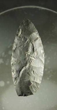 |
Figure 15. Specimen 75478 close up of polish. | 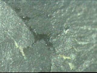 |
| Figure 16. Specimen 76305. | 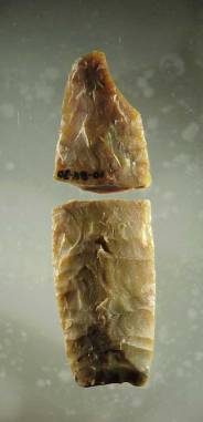 |
Figure 17. Specimen 76305 close up of grinding. | 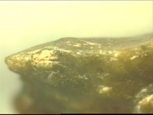 |
| Figure 18. Specimen 76276. | 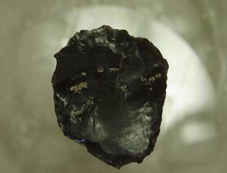 |
Figure 19. 76276 close up of striation. |  |
Wasden is the reconstruction of specific behaviors and event centered history, but in so far as that may be all that can be said of the site at this time. The archaeological record for the surrounding area lacks the documentation for this time period to articulate the Wasden site with into a larger construction. In Idaho, few of the published reports of sites have the time depth of Wasden and most of these lack the material recovered at Wasden. Wilson Butte Cave, by example, in the Wilson Butte II assemblage has only a few points (N=5) that have been described as Plano, but have almost no faunal association (Gruhn 1961:118-119, Plew 2000:37). The only faunal associated with Wilson Butte Assemblage II is a fragment of a grooved bird bone (Gruhn 1961:119). Bison and Veratic Caves (Swanson 1972) also have Plano material, but once again are without faunal association. Only at the Haskett site (Butler 1965), where Haskett was recovered along with fragments of enamel from bison teeth, is there any indication of faunal remains in association with similar artifactual materials. This leaves the Wasden site as the only dated site, for the time period, in which there is a possibility of recovering human behavior. The Wasden site is thus a reconstruction of specific behaviors, until more information is introduced for the region allowing some level of synthesis.
The significance of the Wasden site cannot be overstated. The two published layers represent unique events in the archaeological record. The archaeological record often consists of secondary or tertiary refuse (artifacts discarded away from their primary use location) and as such losing much of their direct behavioral information (Schiffer 1985). The Wasden site, in contrast, presents primary behavioral information in the remains recovered from layer 17. The two published layers are unique discrete events, and are important in understanding hunter-gatherer ecology on the Snake River Plain. The spatial analysis of the Wasden site based on the patterning of meat procurement. The Wasden site offers an interesting glimpse into paleoindian hunting and gathering economy. The bison bone bed contains over 70 bison (Butler 1986:129). It would seem to have evidence that would point to bison procurement (entrapment, disposal), butchering practices, and further it should have implications to what are culturally preferred eating practices in meat preference.
Layer 17 is a dense bison bone bed. These occur from between 200 and 250 centimeters in depth, within the Wasden Site. These remains have been reported to be the results of two separate drive occurrences. As has already been noted above, the site itself, has 7757 large faunal remains recovered, numbered, and in the master Wasden database. The database includes faunal remains identified to be camel, mammoth, bison, and various carnivore species, bear, coyote as well as badger. From this larger group those remains from layer 17 represent 6113 of the total. Most of the faunal remains from the entire site are from layer 17. Layer 17 is overwhelmingly bison remains. Of the 6113 remains only 29 are identified as being other than bison, 14 called carnivore, 9 called canine, 2 coyote, 1 badger, 1 marmot, 1 dog, and 1 bird. This leaves 6084 faunal bison remains in a layer that is between 20 and 50 centimeters thick, an extraordinary amount of material in a small space. Of these 1882 are identified as being in grid units E4D and E4E, and 1827 in the four grid units E1B, E1C, E2Cand E3C, giving a total of 3709 faunal remains in six grid units. These six units, E4D and E4E, and E1B, E1C, E2C, and E3C, are indicative of the bone piling mentioned by Butler (1986:129).
Wasden is a site unlike any in the archaeological literature. It represents quite clearly the contingent nature of the archaeological record. The Wasden site represents what appears to be a natural animal trap. The animals needed little or no inducement to enter the cave. The hunters at Wasden drove the bison into Owl Cave in two separate events. These events occurred closely in time, as no visible separation between the two events is present in the site stratigraphy. The two separate drives were reported by Butler (1986:129) to represent :
[T]wo different kills were involved, one just before the onset of the calving season and one just after. . .a well-planned and coordinated undertaking in which herds of 30 or more Bison antiquus were induced or driven into the cave, dispatched with spear thrust into the body cavity and then systematically butchered.
Butler states (1986:129, citing a 1978 personal communication with George Frison) that this is similar to a pattern found in the northwestern plains in sites of similar age, based on material remains. This is similar to the pattern found by Speth (1983:163), which indicates that female bison would have been preferred during the early winter, due to fat concentrations being higher in females during the early winter than that of males, with the reciprocal being true in the early summer. The two different kills are evidenced by the inclusion of fetal bone material, indicating a late winter to early spring (Miller 1989:383), and a late spring or early summer, evidenced by the inclusion of material deemed to be juvenile. The evidence of the separation is in the presence of fetal and juvenile bison in the recovered remains. Each drive has the remains of roughly thirty bison. Parts of the bison were removed and taken away from the site, either because of cultural preference or because they represent discrete food packages, that are easy to take to residential site.
| Figure 30. Provenience of fetal bones recovered from the Wasden site. | 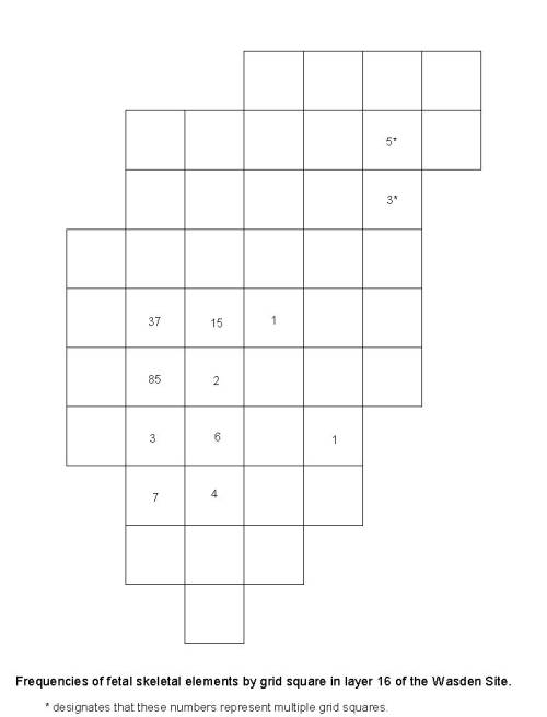 |
The separation of the two drives is in where fetal material is recovered. The activity group probably drove the bison in this layer into cave, given the numbers of bison recovered from the layer. They butchered the bison, and utilized the bison over a few months in the case of the winter kill, and the fact that some of the bone seems to have been utilized for marrow extraction. Some part of the bison was removed from the site.
The Wasden site is the convergence of contingent factors. It is a natural animal trap, allowing Paleoindian groups to gather a large amount of animal flesh in a short period of time. In the site the butchering practices seem to reflect the fact that with a large amount of available food the most desirable pieces would be removed and consumed first, and possibly at all. Some of the faunal material was broken indicative of marrow extraction. Due to the quickly perishable nature of marrow it may be that these were broken at the time of butcher and the marrow consumed. Metacarpals, metatarsals, and phalanges were removed and placed into the waste piles. Each of the tests that were run, as well as observations of the data itself yield, more of the data to build the narrative of what happened at the Wasden site over a short period of time around 8000 years ago.
Butler (1986:129) noted that the faunal remains in the bison bone bed at the Wasden site seem to have been piled. The rational explanation seems to be that these remains were separated and piled by the people who were butchering the bison in the cave. Therefore these piles seem to represent primary context for human behavior. As people were butchering an excess of meat, the Wasden site represents the remains of over 70 butchered bison (Butler 1986), they were selecting those parts that were deemed culturally acceptable, or those that returned the greatest investment for time invested in transport given the variables of distance, meat utility, and weight. These parts were processed and some, such as the ribs, which were recovered in much lower numbers than the other elements, were removed from the site. There were only 60 rib fragments recovered in the over 6000 skeletal fragments recovered at the site. The ribs seem to have been removed from the site as a preferred food item. There is an analogous reference in the archaeological literature that could explain the lack of ribs recovered from the Wasden site. Both Binford (1978) and Friesen (2001) use indices to calculate which portions of an animal will be selected for the purpose of drying meat, based on proportion of meat to marrow and fat. The Meat Drying Index (Friesen 2001), a simplification of the Drying Utility Index (Binford 1978), for caribou usage among the Nunamiut, finds that ribs were ideal for the purpose of dried meat given a normed score of 100 in a scale of 100 (Friesen 2001:321, Figure 2). Speth (1983) does not calculate a Drying Index for Bison, but uses Modified General Utility Index to determine the use of other elements within the Garnsey Site in New Mexico. The ribs do not score well in the Modified General Utility Index, based probably on the fact that they do score well in the Meat Utility Index, which calculates the amount of useful flesh to be harvested from particular skeletal elements. Speth (1983:86 Fig. 28) does, however, show that only 18.7% of the ribs given a minimum number of individuals of 35, were recovered from the Garnsey site. At Wasden only 3% given a minimum number of individuals of 70, were recovered from the site.
| Figure 31. Provenience of ribs recovered from the Wasden site. | 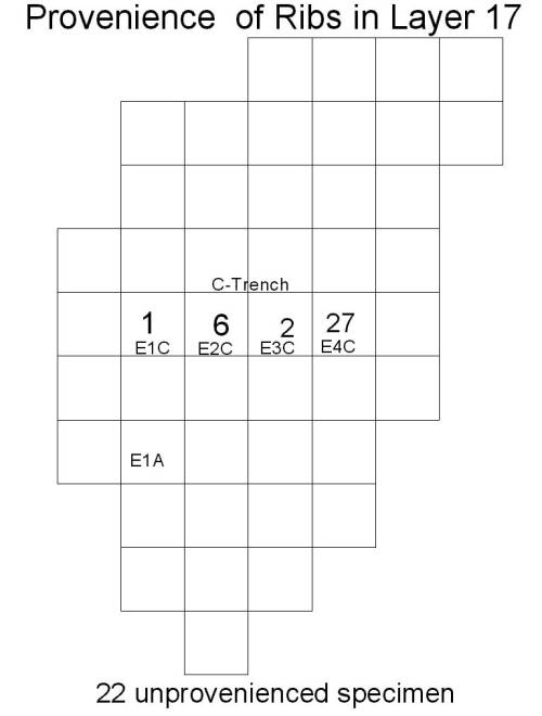 |
Using the indices as a measure of possible use for the Wasden material, it becomes apparent that the Wasden material is follows the general trends that the indices seem to bear out. Metacarpals, Metatarsals, and phalanges, occur in large numbers in the large bone piles that may have been used as waste piles during the butchering process. These elements score extremely low in the indices, and given the large numbers of bison harvested by the activity group at Wasden, it appears that these would have been discarded with minimal use accounting for the high recovery rate.
The discard pattern of the bison remains represent the contingent choices of an over abundance of meat. Those pieces that have less value were discarded. Fetal remains were basically unused and discarded immediately. Speth (1983:114-115) suggests that perhaps due to low levels of subcutaneous, intermuscular, intramuscular, and marrow fat, immature bison were not utilized by processing groups. Those bones outside of the large piles received additional modification, only 32.6% are complete. These bones were broken apart either for marrow extraction or to be used for the creation of bone tools. The site itself represents the cultural patterning of individuals in the archaeological record.
An alternate explanation that could be advanced is that of Wasden as the site of processing, not that of a bison drive. In Bunn and Kroll (1986:434 citing Lartet and Christy 1865-75, and popularized by Perkins and Daly 1968 as the "schlepp effect") the "less nutritional and heavier axial skeletal elements tend to be left at the site of death or butcher and the more nutritious and lighter elements are moved to consumption and processing sites. The "schlepp effect" is used to distinguish between camp sites and kill or butchery sites (Bunn and Kroll 1986:434). At Wasden the axial skeletal elements are under represented, in ribs and skull elements, and perhaps in vertebrae. Which indicates that at Wasden the site was used as for processing of large numbers of bison, but not as a drive site for the bison themselves. This assumes that parts of an estimated seventy bison were moved into the cave at Wasden for processing away from the primary kill site. This does seem unlikely.
Taphonomic processes have influenced the material remains at the Wasden site to an unknown degree. Decay and fluvial sorting seem not to have played a major role at the Wasden site. The site seems to have had excellent preservation of the accumulated faunal remains. Carnivore damage is found in the material remains, but no qualification nor quantification of the extent of damage has been made. However, based on discussions of taphonomic processes, specifically carinvore damage (e.g. Marean et al.1990, 1991;Orloff and Marean 1990; Marean and Spencer 1991), in which carnivores tended to preferentially destroy vertebrae, ribs and pelves, the fact that the pelves and vertebrae were recovered in higher numbers than the ribs may point to the fact that indeed the carnivore damage is low, probably confined to some superficial puncture and gnawing damage.
More work needs to be done in the area around the Wasden site. The site itself is the only archaeological work that has been done in the section and in some of the contiguous sections. If the elements were removed from the site for the purpose of drying else where, that site may be closely associated in an as of yet uncovered location. It would be this site that explains how those removed portions were ultimately utilized. If the Wasden site is that of processing then the kill site may be in adjacent to the site. In either event Wasden would explicate more about the hunter-gatherer economy in Southeastern Idaho at 8000 BP.
HISTORY OF ARCHAEOLOGICAL RESEARCH
Daniel S. Meatte
(Taken from Prehistory of the Western Snake River Basin (1990) pp.21-38)
INTRODUCTION
This review describes the events and ideas that have shaped the study of archaeology in the Western Snake River Basin. The history of archaeological inquiry in the study area can be separated into three time periods based on trends in the published literature. These time periods are best understood as reflecting the concerns of archaeologists working in the region and are set within the broader context of evolving trends in American archaeology. These periods are: Discovery and Description 1889-1957, Classification and Chronology 1957-1969, and Cultural Resource Management: 1969-Present.
DISCOVERY AND DESCRIPTION 1889-1957
From 1889 to 1957, archaeological work was largely a patchwork of individual efforts aimed at exploring and describing the archaeological manifestations in the study area. The first archaeological inquiry in the study area began in 1889 in Nampa, Idaho, under controversial conditions when workmen drilling an artesian well discovered a small clay figurine in sediments brought from 76 cm below the surface (Bird 1976:11). The figure, later called the "Nampa Image," measured 48 mm long. It was modeled in the shape of a human with a visible head, arms and legs (F. Wright 1890). The figure soon became the center of considerable academic debate as to its authenticity and antiquity (American Antiquarian 1890; Henshaw 1890; Holmes 1910, 1919; Idaho Historical Society 1966; Larrabee 1890; Popular Science Monthly 1890; Powell 1893; Putnam 1899; Scientific American 1889; F.W. Wright 1890, 1899; G. F. Wright 1889, 1890, 1891). Supporters such as Professor Frederic W. Putnam, President of the Boston Society of Natural History and Curator of the Peabody Museum, and H. W. Haynes were confident in the antiquity of the figurine, with Haynes claiming it to be the "most important evidence of the great antiquity of man in America" (quoted in Bird 1976:25), while skeptics such as Major John W. Powell considered the figurine a hoax (Powell 1893). Interest in the find eventually waned as the figurine and the circumstances of its discovery became a historical curiosity (T. Green 1982b).
Formal archaeological research in the study area began in 1929 when the Museum of the American Indian, Heye Foundation, sponsored Louis Schellbach's archaeological reconnaissance of southern Idaho (Schellbach 1930). The purpose of this reconnaissance was to locate dry caves suitable for excavation and recover archaeological materials in the "hope of extending the known non-agricultural and Basketmaker area of Nevada and Utah northward" (Schellbach 1930:122). Schellbach selected a dry cave, Cave #1 (10-OE-240), in the southern rimrock overlooking the Snake River Canyon near Melba, Idaho, for excavation (Figure 16). Though materials from this excavation were never formally analyzed or reported, Earl H. Swanson, Jr. arranged for Schellbach's field notes to be published (Schellbach 1967). It is largely due to Swanson's efforts to edit and publish Schellbach's field notes that the significance of Schellbach's efforts are known.
Schellbach's work at Cave #1 (1O-OE-240) represented the first directed excavation in southern Idaho. His recovery of a well preserved collection of perishable artifacts and faunal remains, including a large cache of fishing equipment and paraphernalia, led Schellbach to conclude that "the cave may have been a seasonal fishing station" (Schellbach 1967 :69). The archaeological evidence recovered from Cave #1 was somewhat disappointing for Schellbach in light of his stated purpose. The fishing gear, together with the presence of numerous fish remains throughout the excavated deposits, clearly attested to a more riverine-oriented subsistence rather than the modest, non-agricultural subsistence equipment typical of Nevada and Utah archaeological sites (for a description of anadromous fish remains from Cave #1 see Pavesic et al. 1987).
Perhaps most important of all was that Scheilbach's work at Cave #1 drew attention to the potential wealth of information that could be derived from archaeological sites in the Snake River Plain region of southern Idaho.
The following year, 1930, the Idaho State Historical Society devoted a major part of its Twelfth Biennial Report of the Board of Trustees to Richard P. Erwin's field notes and interpretations of Indian rock art in Idaho (Erwin 1930). This report remains one of the few descriptive surveys of aboriginal rock art in the study area (see also Boreson 1975, 1976a, 1976b; Loring and Loring 1982, 1984; Rees 1928).
At the same time (1930), Matthew Stirling, then chief of the Bureau of American Ethnology conducted a brief survey of archaeological sites in northern Nevada, and test excavated one site (26-EK-7) (Stirling 1931:173). However, a final report on the results of this survey and excavation was never published.
In 1937, the Museum of the American Indian, Heye Foundation, sponsored Godfrey J. Olsen to conduct a survey of southwestern Idaho, concentrating on the Bruneau River. Unfortunately, like Schellbach, Olsen never formally analyzed or reported the results of his survey. Thus, the only information available are his miscellaneous notes (Olsen 1940).
The same year, Dr. Charlton G. Laird, then director of the Historical Museum at the Southern Branch of the University of Idaho (now Idaho State University), excavated Pence-Duerig Cave (10-JE-4), a dry cave in the north rim of the Snake River Canyon, north of Twin Falls, Idaho (Figure 17). The excavations were part of a broader program to build the museum's regional archaeological collections (Butler 1978b:6). Although the excavations were never formally reported, Ruth Gruhn published a brief descriptive report of diagnostic artifactual materials (Gruhn 1961b; Butler 1985a).
Also in 1937, Luther S. Cressman published a detailed report documenting his statewide survey of Indian rock art in Oregon (Cressman 1937). Two years later (1939), Douglas Osborne accompanied Anne M. Cooke and Alden Hayes on an ethnographic survey of "Basin Indians" in Nevada and Utah (Osborne 1941:189). During the course of this survey, Osborne had the opportunity to investigate several archaeological sites and test excavate a cave site (26-EK-6) south of the town of Owyhee, Nevada. Like Stirling's work, final descriptive reports on the materials excavated by Osborne have never been published.
In 1945, a national archaeological survey and salvage program called the Inter-Agency Archaeological Salvage Program (River Basin Surveys) was created through a cooperative agreement between the National Park Service, Smithsonian Institution, the Bureau of Reclamation and the Corps of Army Engineers (Jennings 1985:282). The purpose of this program was to locate, assess and salvage archaeological materials from proposed reservoir construction sites throughout the United States (Jennings 1985:282-283). From 1945 to 1953, ten proposed reservoirs within the study area were surveyed as part of a larger survey project conducted within the Columbia River watershed.
In southwestern Idaho, eight proposed reservoirs were surveyed: Anderson Ranch Reservoir (Daugherty and Riddell 1947), Cascade Reservoir, Smith's Ferry Reservoir, Scriver Creek Reservoir and Garden Valley Reservoir (Drucker 1948), Lucky Peak Reservoir (Osborne 1948a), Lost Valley Reservoir and Horse Flat Reservoir (Osborne 1948b). In southeastern Oregon, one proposed reservoir was surveyed, Bully Creek Reservoir (Osborne 194&). The final survey was of the proposed Hells Canyon Reservoir (Shiner 1951; see Caldwell and Mallory 1967 for a report on salvage excavations; see also Caywood 1948 for a description of an isolated find from this area) bordering Idaho and Oregon.
The results of these surveys are somewhat mixed. A substantial body of site distribution information was generated by the surveys, providing an important regional data base for local investigators. Unfortunately, use of this information was severely limited by the lack of a local chronological sequence. And, while all the surveys were completed and final reports were issued, the data bases they contained was of limited value and has seen minimal use and citation by archaeologists.
The River Basin Surveys program continued as a joint effort between the National Park Service and various state colleges and universities until 1969 when the program was taken over by the National Park Service (Jennings 1985:284).
CLASSIFICATION AND CHRONOLOGY BUILDING: 1957-1969
Up to 1957, archaeological research conducted in the study area represented efforts to survey and assess the characteristics of a region that was, in an archaeological sense, largely unexplored. Most of these efforts brought forth tantalizing evidence of the archaeological potential of the region, but they did not develop a regional, chronological framework.
In 1957, Dr. Earl H. Swanson, Jr. was appointed director of the Idaho State College Museum at Pocatello. There, Swanson began what was to become a life-long commitment to regional archaeology on the Snake River Plain. Swanson initiated an ambitious program aimed at systematically delineating the regional prehistory. This effort began with the creation of two publications, a quarterly entitled Museum Notes and News, which was soon changed to its familiar name, Tebiwa, and a monograph series, the Occasional Papers of the Idaho State College Museum (Butler 1978b:8). Swanson developed and published in 1958 the first Occasional Papers of the Idaho State College Museum, The Archaeological Survey System of the Museum (Swanson 1958b), which served as the organizing system for the recording of archaeological sites within the state of Idaho.
In 1958 and 1959, with support from the National Park Service and a grant from the American Philosophical Society, Swanson undertook regional archaeological surveys of central and southern Idaho (Swanson 1958, 1965; Swanson et al. 1959; Swanson et al. 1964). Included among these surveys were numerous proposed reservoirs scattered in southwestern Idaho. These surveys included the Little Wood River Extension (Bryan 1958a), Spangler Reservoir (Tuohy 1958a), Guffy Reservoir (Tuohy 1958b), Garden Valley Reservoir (Tuohy 1958c), and Long Tom Reservoir (Tuohy 1958d). Also, a small, 22 unnamed rockshelter (1O-AA-15) within the backwater area of the proposed Guffy Reservoir was selected for test excavation (Tuohy and Swanson 1960:20; see also Swanson 1965 for plan map and soil profiles from lO-AA-15).
The cumulative results of these surveys permitted Swanson to "ascertain the archaeological character of southwestern Idaho and attempt a definition of a prehistoric boundary zone between the Plateau and the Great Basin" (Swanson 1965:24). They also afforded Swanson an enormous artifactual data base with which to begin the process of developing a model of the regional culture history.
The efforts to build such a model began in 1958 when Swanson and Alan Bryan assisted Ruth Gruhn, a doctoral candidate from Harvard University, in examining several archaeological sites recorded earlier that summer during the southern Idaho survey (Gruhn 1961a:9; Swanson et al. 1959). Gruhn was looking for a site containing deeply stratified deposits with a long cultural sequence to build a tentative culture history for the region. Gruhn selected Wilson Butte Cave (10-JE-6), a large cave formed in a lava blister perched on a slight basaltic ridge, approximately 13 km south of Dietrich, Idaho (Figure 18). Gruhn directed excavations at Wilson Butte Cave during the summers of 1959 and 1960 as a joint Idaho State College Museum-Peabody Museum of Harvard University project (Gruhn 1959, 1960a, 1961a 1965).
Gruhn's work at Wilson Butte Cave resulted in the delineation of six artifactual assemblages, which initially spanned a human occupational record of nearly 12,000 years (Gruhn 1961a), but was later extended to nearly 15,000 years (1965). Gruhn noted that the content of these six assemblages indicated a number of cultural affiliations with material culture assemblages common to the Great Basin and the Plains region to the east. She also noted that discernible changes in these affiliations were "in conjunction with major changes in environmental conditions in southern Idaho" (Gruhn 1961a:155).
The significance of Gruhn's excavations at Wilson Butte Cave is readily apparent. With this single excavation, Gruhn provided the first working chronology supported by radiocarbon dates for application to a region (Snake River Plain) that was lacking chronological order. This landmark sequence served as the initial anchor point upon which subsequent excavated materials could be compared and chronologically arranged. Gruhn had also extended back, by several thousand years, the known age estimates for man's presence in North America to nearly 15,000 years B.P. Gruhn's recovery of artifactual remains of such great antiquity clearly demonstrated the potential wealth of archaeological information to be found in southern Idaho.
During her brief stay at Idaho State University, Gruhn also undertook two small excavation projects in southwestern Idaho and wrote descriptive reports on excavated materials from this same area. She excavated an isolated burial in the north rim of the Snake River Canyon (Figure 19), overlooking Shoshone Falls, just north of Twin Falls, Idaho (Gruhn 1960b). The burial contained a single individual, probably male, and an assortment of grave goods, both local and exotic (Gruhn 1960b).
In 1961, Ruth Gruhn and B. Robert Butler undertook test excavations of two sites (10-OE-128 and 129) near Squaw Creek, a tributary of the Snake River in southwestern Idaho (Gruhn 1964). They recovered evidence of two single component sites, one dominated by large side-notched points, the other dominated by lanceolate forms with indented bases.
Gruhn also examined two artifact collections in the Idaho State College Museum (now Idaho Museum of Natural History) that were recovered from sites in southwestern Idaho. The first collection consisted of artifacts recovered by Dr. Charleton G. Laird in 1937 from Pence Duerig Cave (10-JE-4) (Gruhn 1961b). A second, smaller collection described by Gruhn consisted of a burial recovered from the base of an exposed rimrock overlooking the Snake River, 5 km southwest of Melba, Idaho (Gruhn 1961 c).
At this same time, other investigators were contributing interesting data from various excavations in the surrounding region. Alfred W. Bowers, from the University of Idaho, began test excavations in 1957 at the Dean site, a stratified campsite at the headwaters of Cedar Creek, just southwest of Rogerson, Idaho (Figure 20). Additional excavations were conducted in the summer of 1958, and culminated in 1959 with a major excavation of the site, jointly financed by the University of Idaho and the National Science Foundation (Bowers and Savage 1962:2; Barnes 1964). Results of these investigations revealed a long, but undated sequence of human occupation, estimated to date from 10,000 years B.P. to historic times (Bowers and Savage 1962).
John E. Wells, then a graduate student of the University of Oregon, undertook excavations in 1958 of a small cave on the north bank of the Malheur River, approximately 5 km downstream from the town of Juntura, in eastern Oregon along the Idaho border. Though lacking radiocarbon dates, Wells did establish a relative chronology for the site, based upon the identification of three stratigraphically distinct occupational levels (J. Wells 1959:9, Profile II).
Robson Bonnichsen excavated a small overhang in Rattlesnake Canyon, overlooking the Snake River, south of Mountain Home, Idaho, (Bonnichsen 1964) in 1960. Bonnichsen recovered evidence of early historic cremation burials. The burials consisted of a large pit containing two separate layers of cremated remains. In the upper layer, the remains of at least five individuals were found. In the lower layer, only one partially burned individual was found (Bonnichsen 1964:28). The site represented the only known historic, cremation burials from the region.
In Nevada, Mary E. and Dr. Richard Shutler, under sponsorship from the Nevada State Museum, excavated a small dry cave located on the north bank of Deer Creek, a tributary to the Jarbidge River in the extreme northeastern corner of Nevada (Shutler and Shutler 1963). The cave contained a deep, stratified sequence of occupational surfaces spanning the past 10,000 years. Like Wilson Butte Cave, the assemblage from Deer Creek Cave provided western archaeologists with an additional linkage of chronologically ordered material culture from a region that was vastly unexplored.
The eastern Snake River Plain region quickly became the focus for archaeological investigations during the 1960s as Earl H. Swanson, Jr. continued to actively build the academic program in anthropology at Idaho State University (Butler 1966, 1968:15; W. Davis 1975:10; Swanson 1972:5-8). The First Conference of Western Archaeologists on Problems of Point Typology was held at the Idaho State College Museum in March of 1962. This conference served as a forum for western archaeologists "to examine concepts of typology and to review existing situations in the typology of points important in Western prehistory" (Swanson and Butler 1962:5). Contracting programs with state and federal agencies, long-term research programs such as the Birch Creek Project, and a developing anthropology curriculum all contributed to this growing research and academic base. The western Snake River Plain region saw increased archaeological activity during the 1960s, but the studies were largely salvage-oriented with limited research constraints. In the fall of 1961, Mr. and Mrs. W.A. Simon of Fairfield, Idaho, discovered a cache of artifacts on their farm while grading a road (Figure 21). The cache consisted of 29 specimens and a single unworked spall (for a total of 30 recovered items); six Clovis lanceolate points, 17 oval points (bifaces), six undescribed implements, and a spall fragment (Butler 1963:44; Butler and Fitzwater 1965). In 1967, 1968 and 1969, Earl H. Swanson Jr. undertook additional reconnaissance and exploratory excavations at the Simon site to establish more accurately the geologic association and age of the Clovis artifacts (Swanson et al. n.d.:3-4). Despite an extensive search of the site locale, only three additional pieces were recovered, two of which were recovered in situ (Swanson et al. n.d.:5 and figure 12).
Also in 1961, an amateur archaeologist, Mr. Lawrence Olsen of Sterling, Idaho, along with several friends, excavated Columbet Creek Rockshelter in the Jarbidge Mountains of southwestern Idaho along the Idaho-Nevada border (Lynch and Olsen 1964). The archaeological value of this site was severely reduced by the lack of stratigraphic controls and proper recording procedures. However, the rich assortment of artifacts and perishable goods recovered from this deeply stratified rockshelter, including an ochre-filled pouch, burned matting, vegetable fiber twine, and human hair, attest to the variety of material goods to be found in the regional archaeological record (Lynch and Olsen 1964:8-9).
In 1962, Claude Warren, acting Highway Archaeologist for the State of Idaho, began salvage excavations at the Midvale locality (Figure 22), where a group of ten sites was to be affected by a proposed realignment of State Highway 95, near Midvale, Idaho (Bucy 1974; Dort 1964; Warren et al. 1971). The salvage excavations focused on a basalt quarry area and led to the definition of an important regional phase, termed the Midvale Complex (Warren et al. 1971:51).
Alfred Bowers of the University of Idaho contracted with the National Park Service to survey the proposed Spangler Reservoir at Mann Creek, near Weiser, Idaho, (Bowers 1967) in 1964. Bowers returned the following year to direct salvage excavations of several sites in the proposed pool area and directed a county-wide survey (Adams County) which ran concurrently with the excavations at Spangler Reservoir (Bowers 1967:15).
Boise State College (now Boise State University), conducted its first archaeological field school program under the direction of anthropology instructor T. Virginia Cox. The field school was conducted at the Braden Site (10-WN-1 17), an early Archaic cemetery situated on a low terrace overlooking the Snake River near Weiser, Idaho (Figure 23). The next year (1968), Idaho State University joined with Boise State College under the supervision of B. Robert Butler to continue the field school and excavations at the Braden site (Butler 1980a).
Also in 1967, Max Pavesic, of Idaho State University (Pavesic 1967), contracted with the Bureau of Reclamation to conduct archaeological surveys of two proposed reservoir development projects in southwestern Idaho. The same year, the Explorers Club of New York City sponsored a project led by Larry Agenbroad to survey and map a purported bison jump complex in the Owyhee Uplands of southwestern Idaho (Agenbroad 1976, 1978). Agenbroad later returned in 1969 to conduct additional mapping of the site complex (Agenbroad 1976, 1978).
By 1969, archaeologists had undertaken numerous regional surveys, conducted major excavations and possessed a firm understanding of the regional culture history in the study area. The excavation of caves and rockshelters containing deeply stratified deposits established a number of temporal anchor points (i.e., Wilson Butte Cave and Deer Creek Cave) which provided a means of building a broader regional chronology (Butler 1968). Research problems generated by these activities provided the impetus to develop and further refine this chronology, as well as seek broader theoretical explanations for the regional archaeological manifestations. These research problems included such questions as: understanding the age and character of early man sites (Butler 1963; Butler and Fitzwater 1965, Gruhn 1961a); establishing geographical limits of major culture areas such as the Great Basin, the Plains, and the Plateau (Swanson 1960, 1965); the documentation of late Pleistocene-Holocene environmental changes and their correlation with culture change (Gruhn 1961a; Swanson 1961), the antecedents of the ethnographic pattern (Swanson 1966b); and the origins of Shoshone pottery (Coale 1963; Tuohy 1956).
CULTURAL RESOURCE MANAGEMENT: 1969-PRESENT
The addition of new federal preservation laws beginning with the 1969 National Environmental Policy Act (U.S. Code 83 Stat. 852) dramatically changed archaeology as a profession, both at the national and state levels. The creation of a federal hierarchy of archaeological positions charged with inventory and evaluation of cultural resources on federal lands shifted personnel and research interests into new domains. The compliance work generated by the federal agencies, primarily the Bureau of Land Management and Forest Service, created a flood of projects, which, in turn, generated a wealth of literature, some good and some bad.
During this decade (1970s), archaeological investigations in southern Idaho, eastern Oregon and northern Nevada were dominated by the federal compliance work, although many research projects were undertaken during this time as well. Regrettably, it is impossible to describe here all of the literature pertaining to the study area (summaries can be found in Gaston 1982, 1983, 1984, 1985, 1986; Wylie 1978; Wylie and Flynn 1977). The sheer volume of this literature is simply overwhelming. Unpublished reports, manuscripts, and letter reports have increasingly become the standard "currency" of federal and state compliance work. While much of this literature documents the absence of archaeological resources in a prescribed location, it nevertheless represents archaeological data. To a given researcher, absence of archaeological sites within a prescribed area is as important as presence. The need for published bibliographic inventories of federal- and state-generated literature, trivial and substantial, is desperately needed.
Due to the sizable volume of literature, only the more significant reports have been reviewed here. The weighing of this literature as to what is relevant and/or significant was somewhat arbitrary considering the variety of research and management interests that exist. This review focused on excavations and survey projects that contain data relevant to chronology building, subsistence and settlement reconstruction, and or processual explanations. A complete listing of archaeological surveys and excavations conducted within the study area are shown in Appendices I and II.
The first major archaeological excavation to be conducted in the study area under the newly created federal legislation was in 1970. Salvage excavations within a Forest Service road right-of-way were conducted at the Rock Creek site (1O-CA-33), an open camp and workshop site in Cassia Mountains of southcentral Idaho (J. Green 1972; Pavesic and Green 1971). Archaeological work at the Rock Creek site revealed five occupation periods spanning some 8,000 years from approximately 10,500 years B.P. to 2,000 years B.P. (J. Green 1972).
Later, in 1978, unauthorized construction activities in previously disturbed portions of the site area, necessitated an assessment of the damage (Bousman, et al. 1979). Exploratory test excavations, coupled with extensive post-hole augering, were conducted primarily in areas outside the original right-of-way impact area examined by Pavesic and Green (Bousman et al. 1979).
In 1971, Jason W. Smith joined the faculty at Boise State College and initiated a research program focused on southern Idaho archaeology (Smith and Smith 1971). The program began with the creation of the Idaho Archaeological Society, a non-profit association of amateur and professional archaeologists whose purpose was "to provide an organization dedicated to the preservation and interpretation of the cultural heritage of Idaho through the mediums of anthropology and archaeology" (Idaho Archaeological Society Charter). The Idaho Archaeological Society initially served as a forum for group meetings, field trips, and classroom instruction in archaeological field and laboratory methods. Since its inception, the organization has grown steadily in membership and assumed a large role in Idaho archaeology, sponsoring an annual professional conference and publishing a quarterly journal, the Idaho Archaeologist.
In the spring of 1972, Smith organized a regional conference, The 1st International Cordilleran Conference (March 4-5, 1972), at Boise State College to provide a forum for the presentation of current archaeological research from the intermontane west. Sponsored jointly by Boise State College and the Idaho Archaeological Society, the conference filled an important void in the local archaeology by providing an accessible forum for the growing population of archaeologists in southern Idaho and eastern Oregon. While the conference was successful in format and content, its intended goal of annual meetings was never realized.
The Idaho State Highway Archaeology program was relocated from Idaho State University to Boise State College in 1973 in an effort to centralize the administrative offices of the Idaho State Highway Department (now Idaho Department of Transportation). Max G. Pavesic, Program Director, integrated the contracting program with educational facilities at Boise State College to provide students with practical job experience working on various surveys and salvage projects across the state. Kenneth Ames directed the program from 1975 until 1978, when the program was absorbed by the Idaho Department of Transportation and an in-house archaeologist, Jenna Gaston, was appointed.
After implementing the Highway Salvage program at Boise State College, Pavesic then focused on establishing research objectives to develop local archaeological resources (Pavesic 1978a). These goals included the formation of a statewide archaeological conference in conjunction with the Idaho Archaeological Society, the development and refinement of the local chronological sequences (Webster 1978; Webster and Peterson 1974, 1975), intensive site survey programs of poorly studied areas (Metzler 1976a, 1976b, 1977a; Pavesic and Meatte 1981; Plew1976a, 1978a), the delineation of an early Archaic burial pattern indigenous to western Idaho (Pavesic 1979, 1985), the reconstruction of aboriginal anadromous fisheries (Meatte 1982, 1983; Pavesic 1986a; Pavesic et al. 1987; Plew 1980f, 1983c), and studies of Shoshone ethnohistory (Meatte 1986b; Pavesic 1978b). Pavesic also implemented an archaeological monograph series entitled Boise State University, Archaeological Reports that continues today. Published on an irregular basis, the series presents "field and laboratory investigation results with either basic or applied research objectives" (Editors' preface).
At Boise State University, the first research project attempted to develop a local chronological sequence. The project was the excavation of Dry Creek Rockshelter (10-AA-68), a small sheltered overhang in the foothills north of Boise, Idaho, (Figure 24). The excavation was conducted in 1975 by Gary Webster, under the direction of Max G. Pavesic (Webster and Peterson 1975; Webster 1978). Webster documented a long, dated sequence of cultural occupations, the first from southwestern Idaho, ranging from 4,100 years B.P. to 1,300 years B.P. The sequence contained a significant collection of material culture and two human burials (Webster 1978:9). Just prior to the excavations at Dry Creek Rockshelter, a small rockshelter (10-AA-67) in the same vicinity was test excavated, but with minimal results (Webster and Peterson 1974).
In a cooperative effort between Boise State University and Indiana University Museum, Mark G. Plew conducted an inventory survey of federal lands along the Camas Creek drainage basin in the Owyhee Uplands of southwestern Idaho (Plew 1976a, 1985). A nearly identical effort was underway some 80 km away. This time, in a cooperative effort between Boise State University and Washington State University, Sharon Metzler conducted an inventory survey of federal lands along the Brown Creek drainage basin in the Owyhee Uplands of southwestern Idaho (Metzler 1976b). These two projects marked the first intensive surveys of the Owyhee Uplands region.
In 1978, Pavesic undertook an inventory survey of a large tract of private land east of Weiser, Idaho (Pavesic and Meatte 1981). In conjunction with this survey, test excavations were resumed at the Braden Burial site (10-WN-1 17), also near Weiser, Idaho. The excavations were intended to relocate and salvage existing cultural materials which were to be affected by a proposed sewer and drainage field (Pavesic 1979:7). These excavations indicated that portions of the site area were still intact as evidenced by the discovery of a possible burial pit containing a cache of large "turkey-tailed" bifaces (Pavesic 1979:9).
In 1979, Pavesic conducted archaeological test excavations at the Hagerman National Fish Hatchery (Figure 25), near Hagerman, Idaho, under contract with the U.S. Corps of Engineers. The investigations assessed the impact of a proposed expansion of hatchery facilities upon archaeological resources within the existing hatchery complex (Pavesic and Meatte 1980:1). Results of the test excavations indicated a significant site area (l0-GG-176) containing buried cultural features, including occupational surfaces, cache pits and several saucer-shaped features judged to be house structures (Pavesic and Meatte 1980:75-79). Age estimates suggested the site was occupied somewhere between 500 to 1,100 years B.P. (Pavesic and Meatte 1980:79). Additional test excavations at Hager-man National Fish Hatchery (lO-GG-176) were conducted by Eastern Washington University, Cheney, Washington, (Landis and Lothson 1983; Lothson and Virga 1981) and Western Heritage, Olympia, Washington, (Daugherty and Welch 1985) to further assess the impact of proposed construction activities upon existing cultural resources. Results of these testing activities reaffirmed the earlier conclusions and interpretations of Pavesic and Meatte (1980), and, in one case, were nullified by the fact that provisions for laboratory analysis were not a requirement of the contract (Lothson and Virga 1982).
As a result of mitigation needs, Kenneth Ames of Boise State University conducted salvage excavations of The Narrows Site (10-EL-296), an open campsite along the Snake River near Glenns Ferry, Idaho, (Ames 1976). The salvage excavations recovered no definable features and a rather small collection of artifactual material. Based on the presence of diagnostic artifacts, Ames estimated the site was sporadically occupied over the past 5,000 years (Ames 1976:10).
Downstream from The Narrows Site, near Swan Falls Dam, Kenneth Ames conducted test excavations at the Swan Falls Dam site (10-AA-17) for the Idaho Power Company (Ames 1982b). These test excavations (Figure 26) exposed a well-preserved, late prehistoric wickiup approximately three meters in diameter and covered with a thick mat of rye grass (Ames 1983:22). Radiocarbon dates obtained from the rye grass matting were contradictory, but Ames postulated a probable age of 600 to 800 years B.P. (1983:29).
Along the South Fork of the Payette River in west-central Idaho, Ames conducted test excavations of several sites recorded earlier during a survey of a proposed highway corridor between Garden Valley and Lowmen, Idaho, (Ames 1982a; Moore and Ames 1979). Results of these testing activities were relatively meager with low artifact densities and few time-sensitive artifacts recovered (Ames 1982a).
Ames also conducted test excavations at a series of sites within a proposed transmission line route running southward from the North Fork Hydroelectric Project along Squaw Creek to Montour, Idaho, and a site at the proposed Hydroelectric Project on the North Fork of the Payette River (Ames 1980, 1982a). These test excavations produced a limited amount of diagnostic artifacts suggesting sporadic occupation in the region for possibly the past 5,000 years (Ames 1982a:77).
Ames and Plew co-directed test excavations at the Silver Bridge Site (10-BO-1) on the North Fork of the Payette River north of Banks, Idaho. Data recovered from the test excavations revealed uniform sediments containing a small assemblage of diagnostic artifacts (Plew et al. 1984:66-67, 97). An age range of 2,000 to 5,000 years B.P. was estimated for the occupations based on point typology, obsidian hydration dates and a single radiometric date (1984:51).
In 1986 and 1987, Mark Plew directed the Boise State University field school at a late prehistoric campsite along the Snake River, near Glenns Ferry, Idaho. Excavations at Three Island Crossing (10-EL-294) revealed the presence of a small house structure (wickiup?), two living surfaces, and a large collection of pottery and anadromous fish remains (Meyer and Gould 1987). Three radiometric dates placed the age of the house structure at approximately 900 years B.P. (Mark Plew, personal communication 1988).
Also, Plew and members of the Idaho Archaeological Society conducted test excavations at Nahas Cave (10-OE-1674) on Pole Creek in Owyhee County, Idaho (Figure 27). The excavation was undertaken to recover a long, dated occupation sequence for the Owyhee Uplands region (Plew 1980f, g, 1981a, 1986b, 1987a; Plew and Woods 1985b). Results of the excavations indicated that Nahas Cave had been sporadically occupied for the past 6,000 years (Plew 1986b:98). The Nahas Cave chronology appears to substantiate an earlier four-phase chronology for the Owyhee Uplands developed by Plew (1979b).
Thomas Green of the Idaho State Historic Preservation Office, in conjunction with the Idaho Archaeological Society, undertook a long-term research project to describe and assess the culture history along the Snake River region in southwestern Idaho (T. Green 1982a; Moe 1978). This project focused on a series of sites at Givens Hot Springs, along the Snake River in southwestern Idaho (Figure 28). Beginning in the summer of 1979, excavations revealed a large number of house pit features associated with a wealth of artifactual debris ('I'. Green 1982a:41). Age assessments for the various house structures and their associated features range from 700 years B.P. to 4,000 years B.P. (T. Green 1982a:42). The house features range in size from small, saucer shaped basins (3.75 m in diameter), to large, steep-sided pit houses (6.75 m in diameter) containing internal roof posts (Green 1988). Additional work has been conducted by Green at a nearby site, Mud Springs (1O-OE-2614), revealing similar house structures (Figure 29) (Davis and Green 1988).
Idaho State University continued to conduct archaeological investigations in the study area primarily in the context of state and federal compliance work (Butler 1976, 1977, 1978a, 1982a, 1984; Butler and Murphey 1982a, 1982b, 1983; Butler and Waite 1978a, 1978b; Cinadr 1976; Polk 1974; Struthers 1976a, b; see Appendices I and II).
Archaeological investigations in the study area by the University of Idaho are limited to several cultural resource surveys (Knudson and Pfaff 1980; Moe et al. 1980; Murphey 1977a, b), and a salvage excavation of a prehistoric campsite (Figure 30) situated within a proposed spillway addition to the existing Lucky Peak Dam, near Boise, Idaho, (Knudson 1977; Sappington 1982). Salvage excavations were conducted by Lee Sappington in 1977 at the Lydle Gulch site (10-AA-72) after initial test excavations indicated a sizable site area existed within the proposed construction area (Sappington 1982:1-2). Sappington documented six natural stratigraphic units containing two cultural components (Sappington 1982:iii). Radiocarbon dates placed the age of the upper component at 800-1,200 years B.P., but no absolute age assessment was determined for the lower component (Sappington 1982:177).
Idaho Archaeological Consultants, Boise, Idaho, performed test excavations in several localities along the Snake River in southwestern Idaho. At the Snake River Birds of Prey Natural Area, in southwestern Idaho, seven sites (10-AA-28, 29, 30, 31, 32, 33, and 166) were test excavated for the Idaho Nature Conservancy (Plew 1980c). These excavations indicated the presence of a possible house structure in association with an assemblage of late period diagnostic artifacts dating to approximately 700 years B.P. (Plew 1980c:40).
Upstream, near Bliss, Idaho, Idaho Archaeological Consultants undertook extensive test excavations at four prehistoric sites (10-GG-1, 1O-TF-352, 354, and 350) within a proposed reservoir pool area (Figure 31). These test excavations produced a wealth of cultural material representing three distinct temporal components spanning some 4,000 to 5,000 years (Plew 1981c:167).
B. Robert Butler Associates, Pocatello, Idaho, undertook a resurvey of the proposed Dike Hydroelectric project along the Snake River near King Hill, Idaho, (Butler and Murphey 1982b). During this survey, test excavations were performed at an unnamed site (10-EL-216) near Bancroft Springs. These excavations revealed a housepit associated with late archaic artifactual materials that were interpreted as "probably Fremont in origin" (Butler and Murphey 1982b:12). The following year, test excavations by B. Robert Butler Associates at the Kanaka Rapids locality (10-GG-273, 275, 278, 1O-TF-320, 529, 531), some 56 km upstream from Bancroft Springs, recovered a small but varied collection of cultural material including projectile points, pottery, ground stone artifacts, faunal remains and a house structure (Butler and Murphey 1983:32-36).
Members of the Hagerman Valley Historical Society, under the direction of Kelley Murphey, Castleford, Idaho, conducted salvage excavations at the Crutchfield Site (10-00-191), along Billingsley Creek north of Hager-man, Idaho (Murphey and Crutchfield 1986). These excavations revealed four possible house features together with an assortment of diagnostic artifacts and faunal remains. Age assessments based on four radiometric dates indicated the site was occupied intermittently from 4,600 to 600 years B.P. (Murphey and Crutchfield 1986:92-95).
The Museum of Anthropology, University of Kansas, conducted an assessment of archaeological resources in the Montour Wildlife/Recreation Area in Gem County, Idaho (Artz 1983). The investigations centered on the assessment of six prehistoric sites (10-GM-SO, 55, 56, 59, 60, and 61) recorded during a previous archaeological inventory of the project area (Hart et al 1975). Results indicated a number of buried components dating from the past 5,300 years B.P. (Artz 1983:146). Of particular interest was the presence of a buried house pit at one of the sites (10-GM-61), dating approximately 3,000 years B.P. (Artz 1983:110).
In Oregon, John Fagan of the University of Oregon, conducted dissertation research in 1970 to assess the nature of Altithermal occupations in spring localities throughout the arid highlands of southeastern Oregon (Fagan 1974:5). Though most of the reconnaissance and test excavations were conducted within the confines of the Great Basin drainage area, five sites (35-AM-24, 25, 26, 30, and 33) within the Snake River drainage, along the upper tributaries of the Owyhee River were examined (Fagan 1974:7). Based on the results of test excavations at these and other sites in the area, Fagan concluded that the region was not completely abandoned during Altithermal times (7,000-5,000 years B.P.). Instead, he proposed that localized conditions and resources were far more important determinants of habitation patterns (Fagan 1974:105).
In 1973, Dave Cole and C. Melvin Aikens, of the University of Oregon, undertook a large-scale excavation at Dirty Shame Rockshelter (35-ML-65) in southeastern Oregon to recover a long chronological sequence. Their excavations revealed a deeply stratified rockshelter containing a wealth of perishable and artifactual materials (Figure 32). Well-preserved house structures, storage pits, floral and faunal remains, and dietary information recovered from human coprolites, provided a detailed information about the shelters' aboriginal occupants. Divisible into six cultural zones, the deposits evidenced human occupations spanning the past 9,500 years with the exception of a hiatus from 5,900 to 2,700 years B.P. (Aikens et al. 1977).
Richard Pettigrew, Oregon State Museum of Anthropology, University of Oregon, conducted salvage excavations at ten sites straddling Stinkingwater Pass, near Buchanan, Oregon, (Pettigrew 1979). Seven of the sites excavated by Pettigrew lie within the Snake River drainage basin (35-HA-69, 70, 71, 72, 74, 75, and 76). Results of these excavations indicated that intensive use of the Stinkingwater Pass area began approximately 4,500 years B.P. and lasted until historic times (1979:59).
Ted Long, of Treasure Valley Community College, conducted excavations at the Moore Ranch site (35-ML-66) near Vale, Oregon (Long 1974, McNeill 1978b). Excavations at the open campsite revealed at least two discreet occupation areas containing a variety of lithic debris and late period projectile points (Long 1974; McNeill 1978b). A small test excavation was conducted by Patrick McNeill of the Bureau of Land Management, Vale District, at the Butler II Site next to Rhinehart Butte, at the confluence of the Malbeur River and Bully Creek, near Vale, Oregon, (McNeil 1978a). The test excavations produced a limited assemblage of cultural material with few or no diagnostic artifacts (McNeill 1978a:1).
In northern Nevada, archaeological test excavations were conducted at the Twin Valley Springs Shelter (26-HU-1075) to assess the context of a possible Pleistocene mountain sheep skull recovered during construction activities at Twin Valley Spring (Madsen 1979). Though results of excavations could not substantiate the Pleistocene age assignment for the mountain sheep skull (Webb and Miller 1979:18-19), they indicated the site was occupied between 8,500 to 2,500 years B.P., and served as a "short-term hunting camp" (Madsen 1979:13).
Most archaeological activities conducted within the study area in the 1970s were cultural resource inventories and assessments of developmental impacts. Due to their somewhat more random distribution over the landscape, these studies were productive in providing archaeologists with new insights into geographic settings previously considered unproductive or marginal. The rapid growth of cultural resource assessments in the 1970s continued into the early 1980s, as a shift toward documenting eligibility of recorded sites was undertaken, usually in the form of exploratory test excavations or of mitigation oriented excavation. The advent of the U. S. economic recession in 1982, however, signaled a decline in state and federally sponsored cultural resource management projects. By 1985 the number of impact studies was reduced significantly to the pre-cultural resource levels of the 1960s.
With the growth of the regional data base during the 1970s, a more refined chronology emerged (T. Green 1982a; Plew 1981c, 1982b; Webster 1978). Commensurate with these developments was a perceptible shift toward formulating regional research designs and developing specific research questions (Ames 1982c). Long-term research programs designed to describe areal settlement patterns were undertaken in the Owyhee Uplands (Plew 1976a, 1978a, 1979b, 1980a; Moe 1978; Murphey 1 985a) and along the South Fork of the Payette River (Ames 1982a; Plew et al. 1984). More specialized analyses involving problem-specific or trait-specific questions have examined archaic burial patterns, such as the Western Idaho Archaic Burial Complex (T. Green et al. 1986; Pavesic 1985), the evidence for fishing in the archaeological record (Meatte 1982, 1986a; Pavesic 1978b, Plew 1983c, 1987a), lithic technology (Plew and Woods 1985c; Woods 1987; Woods and Titmus 1985), and analyses of Shoshone and Fremont pottery (Butler 1979a, 1979b, 1980d, 1981b, 1981c, 1985b, 1987; Plew 1979d, 1980d, 1980e, 1981d).
SUMMARY
In review, it is apparent that until 1957, the initial activities and concerns of archaeologists working in the study area were focused on the exploration, discovery, and description of archaeological resources. Although more developed objectives such as chronology, classification, cultural affiliations, and evolutionary change existed, archaeologists hampered by limited data bases simply could not examine those issues.
The modern foundations of archaeological research in the study area began with the appointment of Earl H. Swanson, Jr. to the Idaho State College Museum in 1957. His personal commitment to understanding the prehistory of Idaho led to the establishment of systematic recording procedures, large areal surveys, the establishment of a tentative regional chronology, and the formulation of well-defined research problems.
With the creation of federal laws governing the protection of archaeological resources and a new hierarchy of state and federal personnel to administer these laws, archaeological advances the past 20 years have been tremendous. Significant headway has been made within the study area to define a regional cultural chronology, and undoubtedly will continue as new sites are excavated and radiometric data are added. Efforts to reconstruct subsistence and settlement patterns, though rare, are becoming increasingly numerous. Few archaeologists have attempted to investigate the underlying processes which explain the archaeological record. No doubt those who undertake more syntheses of archaeological data, improved standardization of techniques and terminology, and synchronic linkages of archaeological and faunal assemblages will lead the way toward explaining these processes.