
About The Profession
Surveying
Surveying is the technique of determining the relative terrestrial or three-dimensional position of different features on, above or beneath the surface of the earth by means of direct or indirect measurements.
These measurement are often used to establish maps and boundaries for ownership, locations, such as building corners or the surface location of subsurface features, or other purposes required by government or civil law, such as property sales.
Surveyors work with elements of geometry, trigonometry, regression analysis, physics, engineering, metrology, programming languages, and the law.
Geomatics
Geomatics is concerned with the collection, distribution, storage, analysis, processing, presentation of geographic data or geographic information. It consists of products, services and tools involved in the collection, integration and management of geographic data.
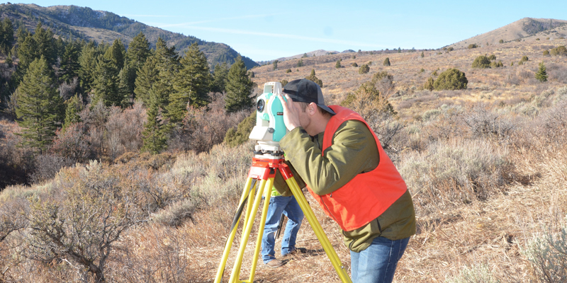
Surveyors/Geomatics Professionals
Surveyors make precise measurements to determine property boundaries. They provide data relevant to the shape and contour of the Earth’s surface for engineering, mapmaking, and construction projects.
Surveyors typically do the following:
- Measure distances and angles between points on, above, and below the Earth’s surface
- Travel to locations and use known reference points to determine the exact location of important features
- Research land records, survey records, and land titles
- Look for evidence of previous boundaries to determine where boundary lines are located
- Record the results of surveying and verify the accuracy of data
- Prepare plots, maps, and reports
- Present findings to clients and government agencies
- Establish official land and water boundaries for deeds, leases, and other legal documents and testify in court regarding survey work
Surveyors mark and document the location of legal property lines. For example, when a house or commercial building is bought or sold, surveyors may mark property boundaries to prevent or resolve disputes.
They use a variety of measuring equipment depending upon the type of survey such as total stations, robotic total stations, theodolites, GNSS receivers, retroreflectors, 3D scanners, radios, clinometer, handheld tablets, digital levels, subsurface locators, drones, GIS, and surveying software.
Surveyors then interpret and verify the results on a computer.
Surveyors work with civil engineers, landscape architects, cartographers and photogrammetrists, and urban and regional planners to develop comprehensive design documents. Surveyors also work with attorneys in the areas of boundary law and legal descriptions.
Survey Technicians
Surveying technicians help surveyors in the field on teams known as survey parties. A typical survey party has a party chief and one or more surveying technicians. The party chief, either a surveyor or a senior surveying technician, leads day-to-day work activities. After data is collected by the survey party, surveying technicians help process the data by entering the data into computers.
Surveying and mapping technicians collect data and make maps of the Earth’s surface. Surveying technicians visit sites to take measurements of the land. Mapping technicians use geographic data to create maps. They both assist surveys and cartographers and photogrammetrists.
The person in charge of the crew, known as the party chief, may be either a surveyor or a senior surveying technician. The party chief leads day-to-day work activities.
Types of surveyors:
Boundary or land surveyors determine the legal property lines and help determine the exact locations of real estate and construction projects.
Engineering or construction surveyors determine the precise location of roads or buildings and proper depths for building foundations. They show changes to the property line and indicate potential restrictions on the property, such as what can be built on it and how large the structure can be. They also may survey the grade and topography of roads.
Forensic surveyors survey and record accident scenes for potential landscape effects.
Geodetic surveyors use high-accuracy technology, including aerial and satellite observations, to measure large areas of the Earth’s surface.
Marine or hydrographic surveyors survey harbors, rivers, and other bodies of water to determine shorelines, the topography of the floor, water depth, and other features.
Mine surveyors survey and map the tunnels in an underground mine. They survey surface mines to determine the volume of materials mined