
Idaho State University MILES grant researchers provide accessible digital history to Portneuf River users
December 10, 2014
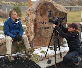
Idaho State University researchers have created a variety of websites and easy-to-use digital web tools aimed at helping the public and all stakeholders understand the history and dynamics of the Portneuf River ecosystem.
“What we are trying to do is create a better public understanding of how the river has been managed in the past, to contribute to community involvement in deciding how the river should be managed in the future,” said Kevin Marsh, ISU history professor and chair, “because providing historical and science-based data on how to manage water in Pocatello is one of the goals of the MILES research project.”
 Marsh is one of the many researchers at ISU participating in the National Science Foundation’s Managing Idaho’s Landscapes for Ecosystems Services (MILES) project that encompasses large regions of Idaho, focusing on the Portneuf, Boise and Coeur d’Alene River watersheds. This project is receiving input for researchers from a variety of academic disciplines from ISU, Boise State University and the University of Idaho. The five-year, $20 million grant is funded by the NSF’s Experimental Program to Stimulate Competitive Research (EPSCoR).
The goal of the MILES is to advance the understanding of feedbacks between social and ecological systems and the services ecosystems provide, such as clean water, water for irrigation or recreation.
Among the new web tools that are created is a digital timeline “Pocatello Flooding History” (at http://miles.isu.edu/Timeline/Overview) created by Marsh and ISU history master’s student Josh Eppley that documents the construction of the Portneuf River cement channel and levies built in Pocatello.
“We’ve created a digital timelines where someone can go through and trace the story through pictures and explanations about how the river was channelized, who did it, when and why,” Marsh said. “It includes local politics, federal government actions and background about the law.”
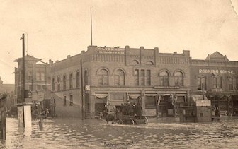 The site traces the decision-making process that led to the final construction of the existing concrete channel in the 1960s, and documents the various proposals for flood control of the Portneuf River.
MILES researchers at ISU have created an assortment of other digital tools for understanding the river, all accessible via links on the web at http://miles.isu.edu/visualizations.shtml, including a “Compare Pocatello 1959 and 2013” site where users can compare a 1959 aerial image of Pocatello to a 2013 aerial image, and see how the Portneuf River channel was changed by activities in the 1960s. This tool was created by ISU geosciences Assistant Research Professor Donna Delparte and a geosciences graduate student W. Joel Johansen. Users can click on a 1959 photo, drag across and see what the same area looked like in 2013.
The ISU researcher emphasize that their tools have been created to be used by the public and stakeholders such as the City of Pocatello and groups like the Portneuf Watershed Partnership, which is a coalition of stakeholders seeking to improve surface and ground water resources in the greater Portneuf Watershed through partnership, outreach, research, monitoring and restoration activities.
“The Portneuf River Flooding timeline and other visual tools recently developed are pertinent to the community and timely as the City of Pocatello works with the U.S. Corps of Engineers in maintaining flood control and the levee system,” said Dave Rodgers, associate dean of the ISU College of Science and Engineering, and ISU’s lead on the MILES project.
“The MILES Portneuf River flooding history website is amazing and has been designed to get community input,” said Hannah Sanger, Science and Environment Division Manager for the City of Pocatello.
She noted that the City of Pocatello is looking at options for the concrete channel on the Portneuf River and how to take it out and maintain flood control. The City has applied for funding for a grant to do a master plan for the Portneuf River.
“We’d like to get community input for what they’d like to see within the flood control channel, and the MILES project is doing all this research and outreach related to it,” Sanger said.
The ISU MILES team will continue to create more visual tools, including 3-D digital models depicting past, current and future scenarios of the river’s uses.
“We have some 3-D virtual representation now and we are building that up,” Delparte said. “We will show them what is there in this virtual world and turn around and show them what could be, based on their input.”
For more information of MILES grant activities based out of Idaho State University, visit www.idahoecosystems.org/research/pocatello.
Categories: